Satellite
In May 1946, Project RAND released Preliminary Design of an Experimental World-Circling Spaceship, which stated, "A satellite vehicle with appropriate instrumentation can be expected to be one of the most potent scientific tools of the Twentieth Century. The achievement of a satellite craft would produce repercussions comparable to the explosion of the atomic bomb." In 1947, Arthur C. Clarke (well known for his science fiction, particularly 2001: A Space Odyssey) presented a paper to the scientific community in which he suggested that if we explored orbits in higher elevations above the earth, we might achieve an orbit at which a satellite would be able to serve as a communications broadcast tool. Until that point, we were beginning early explorations of satellites, but they were what we today would call low-earth-orbit satellites, which means they were at relatively low altitudes over the earth and revolved around the earth much faster than the earth rotates on its own axis. Clarke theorized that if we sent a satellite into a higher orbit, it would encounter a geosynchronous orbit, meaning that the satellite would rotate around the earth at exactly the same rate at which the earth rotates on its axis; the orbiting device would appear to hang stationary over a given point on earth. Clarke's hypotheses were supported and thus began the development of the communications sector for the space industry.
The first artificial satellite was Sputnik 1, launched by the Soviet Union on October 4, 1957. In the United States, NASA launched the first experimental communications satellite in 1963. The first commercial communications satellite was launched two years later, so 1965 marked the beginning of the use of satellite communications to support public telephony as well as television, particularly international television. Since then, large numbers of satellites have been launched. At this point, there are more than 250 communications-based satellites in space, as well as hundreds of other specialized satellites used for meteorological purposes, defense, remote sensing, geological exploration, and so on, for a total of more than 700 satellites orbiting the earth. And it seems that many more satellites will be launched in the future.
There are still approximately 3 billion people on the planet who are not served by even basic communications services, and we can't possibly deploy enough wireline facilities in a short enough time frame to equalize the situation worldwide. Therefore, satellites are very important in bringing infrastructure into areas of the world that have previously not enjoyed that luxury.
In descriptions of satellite services, three abbreviations relate to the applications that are supported:
- FSS Fixed satellite services, the conventional fixed services, are offered in both the C-band and the Ku-band allocations.
- BSS Broadcast satellite services include standard television and direct broadcast. These largely operate in the Ku-band, at 18GHz. Because the general application of television so far has been one way, 18GHz shows just the downlink frequency allocation. As we begin to move toward interactive TV, we'll start to see the use of two different bands in BSS.
- MSS Mobile satellite services accommodate mobility (i.e., mobile users). They make use of either Ka-band or L-band satellites.
A satellite's footprint refers to the area of earth that the satellite's beams cover. Much of the progress in satellite developments has been in new generations of antennas that can provide more spot beams that can deliver higher-quality service to targeted areas rather than simply one big beam, with which users at the fringes of the footprint begin to see a degradation in service.
Another thing that's very important about and unique to satellites is the broadcast property. After you send data uplink to a satellite, it comes back downlink over the entire footprint. So a satellite can achieve point-to-multipoint communications very cost-effectively. This had a dramatic impact on the media business. Consider a big newspaper that has seven regional printing presses within the United States. Before satellites, the paper would have had to send a separate transmission to each of those printing locations so local ads could be inserted and such, but with a satellite, you beam it up once, and when it comes down, it rains over the entire footprint of the United States. If each of the printing presses has a satellite station properly focused on the satellite and knows what frequency to receive on, it will get the information instantaneously.
An interesting design parameter associated with satellites is that as the number of locations increases, the economic benefit of using satellites increases. With leased lines, the more locations and the greater the distances between them, the more expensive the network. But when using satellite technology, the more locations that are sharing the hub station and transponder, the less expensive the network becomes for all concerned. Thus, satellite technology presents a very attractive networking solution for many customers.
Remember that there are 700 or so satellites in space. On top of those 700 satellites, there are about 250,000 pieces of debris that have been cataloged by the space agencies. Furthermore, we are seeing an increase in comet and solar flare activity. A solar flare can decommission a satellite in one pulse, and a little speck of comet dust can put a baseball-sized crater into a solar panel. Because of these types of hazards, strategies must be put in place to protect existing satellites.
We often don't recognize what great capabilities satellite can provide. But if we set our sights on more than just the planet earth and realize that there is a great frontier to explore, we realize that although fiber may be the best solution on the planet, when we want to advance in space, satellite communication is extremely important.
Frequency Allocations of Satellite
The frequency spectrum in which most satellites operate is the microwave frequency spectrum. (GPS runs at VHF frequencies and is a very important application.) Therefore, microwave and satellite signals are really the same thing. The difference is that with satellite, the repeaters for augmenting the signals are placed on platforms that reside in high orbit rather than on terrestrial towers. Of course, this means that the power levels associated with satellite communications are greater than those of terrestrial microwave networks. The actual power required depends on the orbit the satellite operates in (geosynchronous-orbit satellites require the most power, and low-earth-orbit satellites require the least), as well as the size of the dish on the ground. If the satellite has a lot of power, you don't need as big a dish on the ground. This is particularly important for satellite TV, where the dish size should be 2 feet (0.6 m) or smaller. A number of factors are involved in the bandwidth availability of satellite: what spectrum the regulatory agencies have allocated for use within the nation, the portion of the frequency spectrum in which you're actually operating, and the number of transponders you have on the satellite. The transponder is the key communications component in satellite. It accepts the signal coming from the earth station and then shifts that signal to another frequency. When the signal is on the new frequency, it is amplified and rebroadcast downlink.
In satellite communications, the frequency allocations always specify two different bands: One is used for the uplink from earth station to satellite and one for the downlink from satellite to earth station. Many different bands are specified in the various satellite standards, but the most dominant frequency bands used for communications are C-band, Ku-band, Ka-band, and L-band.
C-Band
C-band transmits uplink around the 6GHz range and downlink around the 4GHz range. The advantage of C-band, as compared to other bands, is that because it operates in the lower frequency bands, it is fairly tolerant of adverse weather conditions. It has larger waveforms, so it doesn't suffer as much disturbance as do smaller waveforms in the presence of precipitation, for instance.
The disadvantage of C-band is that its allocation of frequencies is also shared by terrestrial systems. So selecting sites can take time because you have to contend with what your neighbors have installed and are operating. Licensing can take time, as well.
Ku-Band
Ku-band was introduced in the early 1980s, and it revolutionized how we use satellite communications. First, it operates on the uplink at around 14GHz and on the downlink at around 11GHz. The key advantage of Ku-band is that this frequency band allocation is usually reserved specifically for satellite use, so there are no conflicts from terrestrial systems. Therefore, site selection and licensing can take place much more rapidly. Second, because it doesn't interfere with terrestrial systems, it offers portability. Therefore, a Ku-band dish can be placed on top of a news van or inside a briefcase, and a news reporter can go to a story as it is breaking to broadcast it live and without conflict from surrounding systems.
The disadvantage of Ku-band is that it is a slightly higher frequency allocation than C-band, so it can experience distortions under bad climactic conditions (e.g., humidity, fog, rain).
Ka-Band
The new generation of satellitethe broadband satellitesoperates in the Ka-band. The key advantage of Ka-band is that it offers a wide frequency band: about 30GHz uplink and about 20GHz downlink. The difference between 20GHz and 30GHz for Ka-band is much greater than the difference between 4GHz and 6GHz for C-band. This expanded bandwidth means that Ka-band satellites are better prepared than satellites operating at other bands to accommodate telemedicine, tele-education, telesurveillance, and networked interactive games.
A disadvantage of Ka-band is that it's even higher in the frequency band than the other bands, so rain fade (i.e., degradation of signal because of rain) can be a more severe issue. Thus, more intelligent technologies have to be embedded at the terminal points to cost-effectively deal with error detection and correction.
L-Band
L-band operates in the 390MHz to 1,550MHz range, supporting various mobile and fixed applications. Because L-band operates in the lower frequencies, L-band systems are more tolerant of adverse weather conditions than are other systems. It is largely used to support very-small-aperture terminal (VSAT) networks and mobile communications, including handheld terminals (such as PDAs), vehicular devices, and maritime applications.
Satellite Network Segments
Satellite networks have three major segments:
- Space segment The space segment is the actual design of the satellite and the orbit in which it operates. Most satellites have one of two designs: a barrel-shaped satellite, normally used to accommodate standard communications, or a satellite with a very wide wingspan, generally used for television. Satellites are launched into specific orbits to cover the parts of the earth for which coverage is desired.
- Control segment The control segment defines the frequency spectrum over which satellites operate and the types of signaling techniques used between the ground station and the satellite to control those communications.
- Ground segment The ground segment is the earth stationthe antenna designs and the access techniques used to enable multiple conversations to share the links up to the satellite. The ground segment of satellites continues to change as new technologies are introduced.
Satellite Orbits
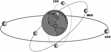
Another important factor that affects the use and application of satellites is the orbits in which they operate. As shown in Figure 2.6, there are three major orbits: geosynchronous orbit (GEO), middle earth orbit (MEO), and low earth orbit (LEO). The majority of communications satellites in use are GEOs.
Figure 2.6. Satellite orbits
GEO Satellites
A GEO satellite is launched to 22,300 miles (36,000 km) above the equator. A signal from such a satellite must travel quite a distance; as a result, there is a delay of 0.25 seconds in each direction, so from the time you say, "Hello, how are you?" to the time that you hear the person's response, "Fine," there is a 0.5-second delay, which results in somewhat of a stilted conversation. Many data applications, especially those that involve entertainment, such as games, cannot perform with a delay this great.
GEO satellites have the benefit of providing the largest footprint of the satellite types. Just three GEO satellites can cover the entire world, but the delay factor in getting to that orbit inhibits its use with the continuously growing range of real-time applications that are very sensitive to delay.
The fact that it is launched at such a high orbit also means that a GEO satellite requires the most power of all the satellite systems. And because the trend in satellites has been to deliver more data as well as interactive services (which are very delay sensitive) directly to the user, more satellites are now being launched at the lower orbits.
We are beginning to see data rates of up to 155Mbps with GEO systems, particularly in the Ka-band. That data rate is not commonly available today, but it is feasible with the new generation of broadband satellites. Going to higher data rates, however, necessitates larger antennas, more so for GEO systems than for satellites in other orbits. Parabolic satellite antennas 33 feet (10 m) in diameter can now be built, and it should soon be possible to extend them to 66 feet (20 m) or 100 feet (30 m).
The main applications of GEO systems are one-way broadcast, VSAT systems, and point-to-multipoint links. There are no delay factors to worry about with one-way broadcasts from GEO systems. As a result, international television is largely distributed over these satellite networks today.
VSATs
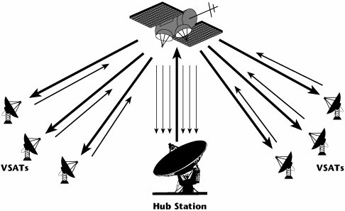
Business enterprises use VSAT networks as a means of private networking, essentially setting up point-to-point links or connections between two locales. A VSAT station is so compact that it can be put outside a window in an office environment. VSATs are commonly deployed to reduce the costs associated with leased lines, and depending on how large the network is, they can reduce those costs by as much as 50%. Most users of VSATs are enterprises that have 100 or more nodes or locations (e.g., banks that have many branches, gas stations that have many locations, convenience stores). VSATs elegantly and economically help these types of enterprises do things such as transport information relevant to a sale made from a remote location to a central point, remotely process information, and process reservations and transactions. (See Figure 2.7.)
Figure 2.7. A VSAT system
Another use for VSATs is business video. Before about 1994, the only way to do point-to-multipoint video was by satellite. No terrestrial conference bridges would allow it. So, if you wanted to have a CEO provide a state-of-the-company address to all employees at different locations, the easiest way to get that footprint was by satellite.
Because you can set up a VSAT system very quickly, VSATs offer valuable help in the event of a major disaster, when land-based facilities are disabled.
VSATs are also useful in vehicle-tracking systems, to communicate with drivers, arrange for payload drop-offs and pickups, and handle standard messaging without disrupting drivers' transportation schedules.
An emerging application for VSAT is broadband Internet access. Products such as Hughes DIRECWAY (www.hns.com) provide Internet downloads at up to 1Mbps. Similarly, intranets (i.e., site-to-site connections between company locations) can be based on VSATs.
The following are the key advantages of VSATs:
- Easy access to remote locations Where it would be difficult to facilitate a wireline arrangement, such as on an oil rig, a VSAT can easily be set up.
- Rapid deployment A VSAT system can be installed in two to four hours (as long as you have already secured the license to operate within an allocated spectrum).
- Scalable A VSAT system can grow to facilitate more bandwidth with the addition of more interfaces.
- Platform agnostic A VSAT can support a variety of data networking protocols.
- Insensitive to distance-related transmission costs The transmission cost is the same whether your locations are 100 miles (150 km) apart or 3,000 miles (5,000 km) apart. As long as the locations are within the footprint of the satellite, the costs are distance insensitive. (This does not necessarily translate to distance-insensitive pricing.)
- Cost reductions via shared-hub facilities The more you share the system, the more your costs are reduced.
- Flexible network configuration You can be flexible with your network configurations. As with a microwave system, you can pick it up and move it.
Disadvantages of VSATs include the following:
- Transmission quality subject to weather conditions Stormy weather can cause disruptions. Most large users of VSAT networks have some leased lines available to use as backup when disruptions occur.
- Potentially high startup costs for small installations A small company may face a high startup cost if it does not have many nodes. (If VSAT is the only available recourseif there is no way to communicate without itthen the installation cost is a moot point.)
MEO Satellites
MEO satellites orbit at an elevation of about 6,200 to 9,400 miles (10,000 to 15,000 km). MEO satellites are closer to the earth than GEO satellites, so they move across the sky much more rapidlyin about one to two hours. As a result, to get global coverage, you need more satellites (about five times more) than with GEO systems. But because the altitude is lower, the delay is also reduced, so instead of a 0.5-second delay, you see a 0.1-second delay.
The main applications for MEOs are in regional networks, to support mobile voice and low-speed data, in the range of 9.6Kbps to 38Kbps. The companies that use MEOs tend to have their movement within a region rather than over the entire globe, so they want a larger footprint over, for example, the Asia-Pacific region, to support mobility of mainly voice communications.
LEO Satellites
LEOs are a lot like cellular networks, except that in the case of LEOs, the cells as well as the users are moving. Because LEOs are in such low orbits, they greatly reduce the transit times, so the delays are comparable to what you'd experience on the PSTN, and therefore delay-sensitive applications can survive. Their low orbits also mean that power consumption is much lower than with a higher-orbiting satellite, so you can direct their transmissions into a user's handheld. Also, LEOs offer greatly increased network capacity overall on a global basis.
LEOs orbit at about 400 to 1,000 miles (640 to 1,600 km). LEOs can be used with smaller terminals than can the other satellites because they are much closer to the earth (40 times closer). But, again, because they are closer, you need many more LEOs than other satellites to get the same coverage (about 20 times more LEOs than GEOs and 5 times more LEOs than MEOs). A user must always be able to see at least one LEO satellite that is well clear of the horizon.
As mentioned earlier, the very first satellites rotated around the earth so fast that we couldn't use them for communications. But LEO satellite platforms include switching, so as a LEO satellite begins to go out of view, a call is switchedthat is, handed overto the next satellite coming in. This works very much like the cellular system, where a caller is handed off to different frequencies during a conversation while transiting between cells. Of course, a benefit of being lower in the sky means that the delay with LEOs is reducedto only about 0.05 secondsand this makes LEOs very appealing for interactive services.
The key applications for LEOs are support for mobile voice, low-speed data, and high-speed data. There are three categories of LEOs, and each category is optimized for certain applications:
- Little LEOs Little LEOs offer 2.4Kbps to 300Kbps and operate in the 800MHz range. They are ideal for delivering messaging, paging, and vehicle location services.
- Big LEOs Big LEOs offer 2.4Kbps to 9.6Kbps and operate in the 2GHz range. They have rather low data rates and are largely designed to provide voice services to areas that aren't currently served by any form of terrestrial or cellular architecture.
- Broadband LEOs Broadband LEOs offer 16Kbps to 155Mbps. They operate in the Ka-band, at 20GHz to 30GHz, and they support data and multimedia files at up to 155Mbps.
Applications of Satellite
The traditional applications for satellites have been to serve remote areas where terrestrial facilities were not available; to provide the capability for point-to-multipoint communications for cost-efficiencies; to provide disaster-recovery support; to provide remote monitoring and control; to facilitate two-way data messaging, vehicle tracking, mobile communications, and maritime and air navigation; to distribute TV, video, and multimedia; and to provide for defense communications.
Two recent applications of new consumer satellite services are automotive navigation and digital audio radio, such as the SIRIUS system, with which you can receive more than 100 radio stations throughout the footprint of the satellite. Not only do you receive the music or programming you want, but you can immediately determine who the artist is and what CD it is from, and you can even compile a customized version for yourself. By now everyone is at least aware of the benefits of automotive systems like GM's OnStar, which not only provide navigational assistance but also support vital emergency services, with the potential to make the difference between life and death.
Satellite is being used in a number of other applications. Use of satellite in Internet backbones is another emerging application because of the huge growth in traffic levels. Terrestrial facilities can't handle all this traffic alone, so we have to rely on some satellite backbones, especially to reach into places such as Africa, Antarctica, and Latin America. Additional emerging applications include Internet access, data caching, and multimedia. The farther you are from the point at which an application resides, the worse the experience you have. If we put applications on a satellite, everybody within the footprint is always only one hop away, thereby greatly reducing the latencies, or delays, encountered in ultimately drawing on the content. Again, what may make a difference here is whether it's an interactive application and what orbit that satellite is in, but this is one application that merges the ISP and satellite industries. Other emerging applications of satellites include telemedicine, distance learning, remote imaging, and weather information.
Satellites have seen a number of innovations and are facing yet more in the future. The most significant change in the coming years is that satellites will increasingly deliver information directly to the consumer rather than to a commercial data hub. This might mean that aerospace corporations become major competitors of traditional telecom carriers.
Another key innovation is phased-array antennas. A phased-array antenna consists of multiple transmitting elements, arranged in a fixed geometric array. These small, flat antennas are steered electronically, and they provide great agility and fast tracking. Phased-array antennas, as well as other new designs in antennas, are discussed in Chapter 13.
Key challenges for satellites today are related to power and mobile services. Because the small antennas now used in portable transceivers intercept only a tiny fraction of the satellite signal, satellites must have a lot of power and sensitivity; a typical solar array on a GEO satellite increased in power from 2kW to more than 10kW in just several years. Another innovation involves moving further up the frequency spectrum, to make use of extremely high frequencies (EHF). The highest-frequency satellite systems today use wavelengths comparable to the size of a raindrop. Consequently, a raindrop can act as a lens, bending the waves and distorting the signals. But these ill effects can be mitigated by using error correction techniques, by applying more power when necessary, or by using more ground terminals so data can follow diverse paths. When wavelengths are smaller than a millimeter, there are yet more obstacles. Infrared and optical beams are easily absorbed in the atmosphere. So, in the near future, they may very well be restricted to use within buildings; however, there have been some new developments in virtual fiber, which is discussed in Chapter 15.
Advantages and Disadvantages of Satellite
The advantages of satellite include the following:
- Access to remote areas
- Coverage of large geographical areas
- Insensitivity to topology
- Distance-insensitive costs
- High bandwidth
The disadvantages of satellite include the following:
- High initial cost
- Propagation delay with GEO systems
- Environmental interference problems
- Licensing requirements
- Regulatory constraints in some regions
- Danger posed by space debris, solar flare activity, and meteor showers
Fiber Optics |
Part I: Communications Fundamentals
Telecommunications Technology Fundamentals
- Telecommunications Technology Fundamentals
- Transmission Lines
- Types of Network Connections
- The Electromagnetic Spectrum and Bandwidth
- Analog and Digital Transmission
- Multiplexing
- Political and Regulatory Forces in Telecommunications
Traditional Transmission Media
Establishing Communications Channels
- Establishing Communications Channels
- Establishing Connections: Networking Modes and Switching Modes
- The PSTN Versus the Internet
The PSTN
- The PSTN
- The PSTN Infrastructure
- The Transport Network Infrastructure
- Signaling Systems
- Intelligent Networks
- SS7 and Next-Generation Networks
Part II: Data Networking and the Internet
Data Communications Basics
- Data Communications Basics
- The Evolution of Data Communications
- Data Flow
- The OSI Reference Model and the TCP/IP Reference Model
Local Area Networking
Wide Area Networking
The Internet and IP Infrastructures
- The Internet and IP Infrastructures
- Internet Basics
- Internet Addressing and Address Resolution
- The Organization of the Internet
- IP QoS
- Whats Next on the Internet
Part III: The New Generation of Networks
IP Services
Next-Generation Networks
- Next-Generation Networks
- The Broadband Evolution
- Multimedia Networking Requirements
- The Broadband Infrastructure
- Next-Generation Networks and Convergence
- The Next-Generation Network Infrastructure
Optical Networking
- Optical Networking
- Optical Networking Today and Tomorrow
- End-to-End Optical Networking
- The Optical Edge
- The Optical Core: Overlay Versus Peer-to-Peer Networking Models
- The IP+Optical Control Plane
- The Migration to Optical Networking
Broadband Access Alternatives
- Broadband Access Alternatives
- Drivers of Broadband Access
- DSL Technology
- Cable TV Networks
- Fiber Solutions
- Wireless Broadband
- Broadband PLT
- HANs
Part IV: Wireless Communications
Wireless Communications Basics
- Wireless Communications Basics
- A Brief History of Wireless Telecommunications
- Wireless Communications Regulations Issues
- Wireless Impairments
- Antennas
- Wireless Bandwidth
- Wireless Signal Modulation
- Spectrum Utilization
Wireless WANs
- Wireless WANs
- 1G: Analog Transmission
- 2G: Digital Cellular Radio
- 5G: Enhanced Data Services
- 3G: Moving Toward Broadband Wireless
- Beyond 3G
- 4G: Wireless Broadband
- 5G: Intelligent Technologies
WMANs, WLANs, and WPANs
Emerging Wireless Applications
- Emerging Wireless Applications
- The Handset Revolution
- Mobile IP
- The IP Multimedia Subsystem
- Mobile Gaming
- Mobile Video
- Mobile TV
- Mobile Content
Glossary
EAN: 2147483647
Pages: 160
