Hack 34. Publish Your Own Hiking Trail Maps


Tell your own stories with a mix of social software and cartography.
We've all found ourselves climbing through hillside brambles on a hot sunny day thinking, "That's the last time I trust that trailhead pamphlet." Or worse, wanting to show a friend a special place you found on a hike a few months ago but now can't quite place.
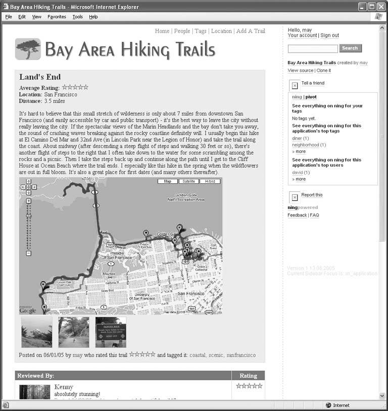
If you're a hiker, mountain biker, rock climber, weekend warrior, amateur geologist, scout troop leader, endorphin junkie, equestrian, pedestrian, rock climber, birder, or simple romantic, then have we got a hack for you! The site, which lives at http://BayAreaHikingTrails.ning.com, looks like Figure 4-17.
Bay Area Hiking Trails (BAHT), written by Saumi Mehta and May Woo, allows you to capture and publish your trail maps with comments, GPS tracklogs, and photos. Even better, you can easily overlay your GPS tracklogs on Google Maps via the API and provide a visual representation of your hike, bike, or ride alongside all these other goodies. But that's only the start. You can also offer these annotated trail maps to friends or strangers for rating and reviewing. You can even look for new hiking friends and fellow enthusiasts. How's that for social?
Figure 4-17. Bay Area Hiking Trails
All right, so that may not be enough. Let's take it one step further. No single social map can cover all scenarios of what you might want to do with it. With just a little bit of PHP knowledge, BAHT enables you to easily change or extend the user input forms so that you can record your own specialized data: birds seen, bikers met, geocaches planted, or geocaches found. You can also go further and change the HTML layout, add new features, or introduce new kinds of objects for your users to edit. Perhaps you are employed by a local parks service to identify invasive plant species and want a new kind of form input to describe those. Or you're a mountain biker who wants to have a slightly specialized social mapping application to document the rockiness, steepness, or exposure of certain trails.
BAHT is extensible for such uses because it is built on the Ning Playground, which is a free online system that enables you to clone, mix, and run fullblown social web apps like BAHT without worrying about a bunch of pesky details. The Ning Playground handles user account management, system administration, hosting, and bandwidth nightmares, not to mention the tedium of performance and scalability issues.
If you don't know PHP, you can still do a lot with BAHT or any social application running on Ning. If you want to copy BAHT to create Malibu Hiking Trails, Bay Area Rock Climbs, Yosemite Mountaineering Routes, or Sonoma Bike Rides, just select the application and choose Clone It on the righthand sidebar to instantly create your own running version of the application, with an exact copy of the code behind the copied application, ready to be customized. You just change the title to apply the app to the place, interest, or activity you want. Now you're all set to start adding your own relevant trails, rocks, mountains, rides, or romantic spots, and invite your friends and neighbors to do the same.
If you know PHP, then it gets even better. You can go under the hood of the app by clicking on "view source," and, with those PHP skills, change the user input forms, add or delete features, or make the app anything you want.
BAHT combines the benefits of gadgets, data, and the real world experience of you and others to help you find and share the perfect place. You can compare your trips against your friends' tripsor blend different trips together to get a composite view of some new trip you've never thought of before.
BAHT helps you return to your favorite places over and over and easily find new favorites. It dissolves boundaries between the professional and the amateur by letting you create your own maps and your own mapping services. Ultimately, perhaps its most powerful role is that it helps you and your friends more easily share something valuable and important: this hugely complex and beautiful natural world we live in. I look forward to seeing what kinds of new projects you invent based on this starting point.
Anselm Hook
You Are Here: Introducing Google Maps
- Hacks 19: Introduction
- Hack 1. Get Around http://maps.google.com
- Hack 2. Find Yourself (and Others) on Google Maps
- Hack 3. Navigate the World in Your Web Browser
- Hack 4. Get the Birds-Eye View
- Hack 5. Driven to a Better User Interface
- Hack 6. Share Google Maps
- Hack 7. Inside Google Maps URLs
- Hack 8. Generate Links to Google Maps in a Spreadsheet
- Hack 9. Use del.icio.us to Keep Up with Google Maps
Introducing the Google Maps API
- Hacks 1016: Introduction
- Hack 10. Add a Google Map to Your Web Site
- Hack 11. Where Did the User Click?
- Hack 12. How Far Is That? Go Beyond Driving Directions
- Hack 13. Create a Route with a Click (or Two)
- Hack 14. Create Custom Map Markers
- Hack 15. Map a Slideshow of Your Travels
- Hack 16. How Big Is the World?
Mashing Up Google Maps
- Hacks 1728: Introduction
- Hack 17. Map the News
- Hack 18. Examine Patterns of Criminal Activity
- Hack 19. Map Local Weather Conditions
- Hack 20. Track Official Storm Reporting
- Hack 21. Track the International Space Station
- Hack 22. Witness the Effects of a Nuclear Explosion
- Hack 23. Find a Place to Live
- Hack 24. Search for Events by Location
- Hack 25. Track Your UPS Packages
- Hack 26. Follow Your Packets Across the Internet
- Hack 27. Add Google Maps to Any Web Site
- Hack 28. How Big Is That, Exactly?
On the Road with Google Maps
- Hacks 2941: Introduction
- Hack 29. Find the Best Gasoline Prices
- Hack 30. Stay Out of Traffic Jams
- Hack 31. Navigate Public Transportation
- Hack 32. Locate a Phone Number
- Hack 33. Why Your Cell Phone Doesnt Work There
- Hack 34. Publish Your Own Hiking Trail Maps
- Hack 35. Load Driving Directions into Your GPS
- Hack 36. Get Driving Directions for More Than Two Locations
- Hack 37. View Your GPS Tracklogs in Google Maps
- Hack 38. Map Your Wardriving Expeditions
- Hack 39. Track Your Every Move with Google Earth
- Hack 40. The Ghost in Google Ride Finder
- Hack 41. How Google Maps Got Me Out of a Traffic Ticket
Google Maps in Words and Pictures
- Hacks 4250: Introduction
- Hack 42. Get More out of What You Read
- Hack 43. Dont Believe Everything You Read on a Map
- Hack 44. You Got Your A9 Local in My Google Maps!
- Hack 45. Share Pictures with Your Community
- Hack 46. Browse Photography by Shooting Location
- Hack 47. Geotag Your Own Photos on Flickr
- Hack 48. Tell Your Communitys Story
- Hack 49. Generate Geocoded RSS from Any Google Map
- Hack 50. Geoblog with Google Maps in Thingster
API Tips and Tricks
- Hacks 5161: Introduction
- Hack 51. Make a Fullscreen Map the Right Way
- Hack 52. Put a Map and HTML into Your Info Windows
- Hack 53. Add Flash Applets to Your Google Maps
- Hack 54. Add a Nicer Info Window to Your Map with TLabel
- Hack 55. Put Photographs on Your Google Maps
- Hack 56. Pin Your Own Maps to Google Maps with TPhoto
- Hack 57. Do a Local Zoom with GxMagnifier
- Hack 58. Find the Right Zoom Level
- Hack 59. Show Lots of StuffQuickly
- Hack 60. Make Things Happen When the Map Moves
- Hack 61. Use the Right Developers Key Automatically
Extreme Google Maps Hacks
- Hacks 6270: Introduction
- Hack 62. Find the Latitude and Longitude of a Street Address
- Hack 63. Read and Write Markers from a MySQL Database
- Hack 64. Build Custom Icons on the Fly
- Hack 65. Add More Imagery with a WMS Interface
- Hack 66. Add Your Own Custom Map
- Hack 67. Serve Custom Map Imagery
- Hack 68. Automatically Cut and Name Custom Map Tiles
- Hack 69. Cluster Markers at High Zoom Levels
- Hack 70. Will the Kids Barf? (and Other Cool Ways to Use Google Maps)
EAN: 2147483647
Pages: 131
