Hack 11. Where Did the User Click?


Find the location of a click on a map and display it on your web page.
Google Maps makes it easy to put an interactive map on your web page. At http://www.naffis.com/maphacks/latandlon.html you can click on a map and have the corresponding latitude and longitude displayed in a Google Maps info box.
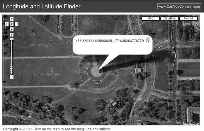
In Figure 2-4 you can see the location of the Washington Monument.
Figure 2-4. The Washington Monument at 38.88941 N, 77.03517 W
This site solves the common problem of figuring out the coordinates of a location from a map view and is an example of the sort of quick hack that Google Maps has made possible. This page illustrates one way to get the latitude and longitude from a click on a map and display results in an info box. So how can you do it? At http://mappinghacks.com/projects/gmaps/click.html there is a simplified example of updating a form from the coordinates of a click on a map.
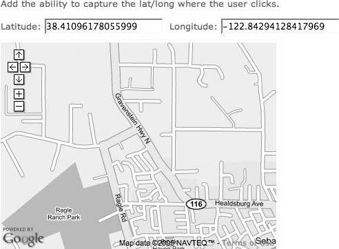
This is the Hello World map with three changes. An HTML form has been added to receive the latitude and longitude from the click event:
Latitude: Longitude:
In the script, the latitude and longitude used to set the initial map location with centerAndZoom( ) now comes from these form elements. This code defaults to starting at 38.4094 N, 122.8290 W. Change those values to change the initial focus of the map. The important change to the script is the addition of a GEvent.addListener. This code and the above form can be pasted into the body of your HTML page. Change the developer's key and you can capture clicks on a map:
This code adds a listener to the GMap object named map. If you click on the map, the code in the event handler will be run. The code is given both an overlay (a marker) and a point. If you click on a marker, the overlay will be set. If you don't click on a marker, then a GPoint object is given to the code.
These two lines are standard JavaScript. They ask the document for the value of the elements click_lat and click_long. The only elements with those names are the form elements. point.x and point.y are the longitude and latitude of the GPoint object that marks where you clicked.
	document.getElementById('click_lat').value = point.y;
	document.getElementById('click_long').value = point.x;
The end result is shown in Figure 2-5.
Figure 2-5. The click is back
The next steps are to add markers to the map from the click, populate a map from an external data source, and update an external data source based on the map.
You Are Here: Introducing Google Maps
- Hacks 19: Introduction
- Hack 1. Get Around http://maps.google.com
- Hack 2. Find Yourself (and Others) on Google Maps
- Hack 3. Navigate the World in Your Web Browser
- Hack 4. Get the Birds-Eye View
- Hack 5. Driven to a Better User Interface
- Hack 6. Share Google Maps
- Hack 7. Inside Google Maps URLs
- Hack 8. Generate Links to Google Maps in a Spreadsheet
- Hack 9. Use del.icio.us to Keep Up with Google Maps
Introducing the Google Maps API
- Hacks 1016: Introduction
- Hack 10. Add a Google Map to Your Web Site
- Hack 11. Where Did the User Click?
- Hack 12. How Far Is That? Go Beyond Driving Directions
- Hack 13. Create a Route with a Click (or Two)
- Hack 14. Create Custom Map Markers
- Hack 15. Map a Slideshow of Your Travels
- Hack 16. How Big Is the World?
Mashing Up Google Maps
- Hacks 1728: Introduction
- Hack 17. Map the News
- Hack 18. Examine Patterns of Criminal Activity
- Hack 19. Map Local Weather Conditions
- Hack 20. Track Official Storm Reporting
- Hack 21. Track the International Space Station
- Hack 22. Witness the Effects of a Nuclear Explosion
- Hack 23. Find a Place to Live
- Hack 24. Search for Events by Location
- Hack 25. Track Your UPS Packages
- Hack 26. Follow Your Packets Across the Internet
- Hack 27. Add Google Maps to Any Web Site
- Hack 28. How Big Is That, Exactly?
On the Road with Google Maps
- Hacks 2941: Introduction
- Hack 29. Find the Best Gasoline Prices
- Hack 30. Stay Out of Traffic Jams
- Hack 31. Navigate Public Transportation
- Hack 32. Locate a Phone Number
- Hack 33. Why Your Cell Phone Doesnt Work There
- Hack 34. Publish Your Own Hiking Trail Maps
- Hack 35. Load Driving Directions into Your GPS
- Hack 36. Get Driving Directions for More Than Two Locations
- Hack 37. View Your GPS Tracklogs in Google Maps
- Hack 38. Map Your Wardriving Expeditions
- Hack 39. Track Your Every Move with Google Earth
- Hack 40. The Ghost in Google Ride Finder
- Hack 41. How Google Maps Got Me Out of a Traffic Ticket
Google Maps in Words and Pictures
- Hacks 4250: Introduction
- Hack 42. Get More out of What You Read
- Hack 43. Dont Believe Everything You Read on a Map
- Hack 44. You Got Your A9 Local in My Google Maps!
- Hack 45. Share Pictures with Your Community
- Hack 46. Browse Photography by Shooting Location
- Hack 47. Geotag Your Own Photos on Flickr
- Hack 48. Tell Your Communitys Story
- Hack 49. Generate Geocoded RSS from Any Google Map
- Hack 50. Geoblog with Google Maps in Thingster
API Tips and Tricks
- Hacks 5161: Introduction
- Hack 51. Make a Fullscreen Map the Right Way
- Hack 52. Put a Map and HTML into Your Info Windows
- Hack 53. Add Flash Applets to Your Google Maps
- Hack 54. Add a Nicer Info Window to Your Map with TLabel
- Hack 55. Put Photographs on Your Google Maps
- Hack 56. Pin Your Own Maps to Google Maps with TPhoto
- Hack 57. Do a Local Zoom with GxMagnifier
- Hack 58. Find the Right Zoom Level
- Hack 59. Show Lots of StuffQuickly
- Hack 60. Make Things Happen When the Map Moves
- Hack 61. Use the Right Developers Key Automatically
Extreme Google Maps Hacks
- Hacks 6270: Introduction
- Hack 62. Find the Latitude and Longitude of a Street Address
- Hack 63. Read and Write Markers from a MySQL Database
- Hack 64. Build Custom Icons on the Fly
- Hack 65. Add More Imagery with a WMS Interface
- Hack 66. Add Your Own Custom Map
- Hack 67. Serve Custom Map Imagery
- Hack 68. Automatically Cut and Name Custom Map Tiles
- Hack 69. Cluster Markers at High Zoom Levels
- Hack 70. Will the Kids Barf? (and Other Cool Ways to Use Google Maps)
EAN: 2147483647
Pages: 131
