Hack 63. Read and Write Markers from a MySQL Database


Keep track of almost anything with Google Maps and a relational database.
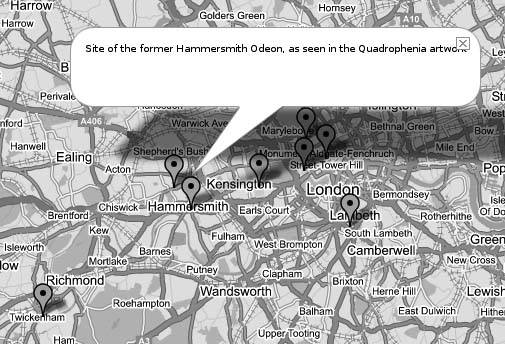
Adding a map of something new to Google Maps is good fun, but there is a lot of data already in SQL databases that is just begging to be mapped. This tutorial describes the way the Subfinder application, at http://www.map-server.com/googlemaps/subfinder.php, is integrated with a MySQL database using PHP. The Subfinder is itself an extension of the Who Locations site at http://www.map-server.com/googlemaps/wholocations2.php, which is described in a tutorial at http://www.map-server.com/googlemaps/tutorial.html. Figure 7-2 shows a map of the sites that any fan of The Who must know about.
There are easier ways to get points on a Google Map, but to integrate with a MySQL database you will need:
- An Apache web server running PHP and MySQL. (Other web server software with PHP and MySQL will probably do as well.)
- A table in your database with lat, long, and description columns.
- Some basic HTML and PHP knowledge.
We are going to use PHP to dynamically create an HTML document with the appropriate Google Maps JavaScript code. One of the functions shown in this sample is the option for users to add their own locations, with additional attributes, into the database. The value of one of the attribute determines the type of marker placed.
Figure 7-2. A map for Who fans
7.3.1. Structuring Your Database
The database can be recreated with this snippet of SQL:
	CREATE TABLE subfinder (
	 id int(11) NOT NULL auto_increment,
	 lat decimal(10,6) NOT NULL default '0.000000',
	 lon decimal(10,6) NOT NULL default '0.000000',
	 desc varchar(255) NOT NULL default '',
	 url varchar(255) NOT NULL default '',
	 marker char(1) NOT NULL default '',
	 PRIMARY KEY (id)
	) TYPE=MyISAM;
If you save this into the file create_subfinder.sql, you can create a new database and this table with the following commands:
	$ mysqladmin create sub_db
	$ mysql sub_db < create_subfinder.sql
As you can see, there are fields for the latitude and longitude values, a description, URL (which will of course be displayed as a link), and a marker field. The value of the marker field will determine the type of marker placed. This application, which lists submarines visible on the Google Maps photos, makes a distinction between submarines that are in active duty (A), museum ships (M), places where submarines have sunk (S), and places where important events have taken place (E). The appropriate letter is displayed in the marker.
7.3.2. The Code
This system uses two PHP files to do its work. The main file, subfinder.php, is used to read the data from the database and display it on the map. The second file, subfinder_load_db.php, is called by the first to write data into the database. A standard HTML form is used for this.
The subfinder.php file imports the Google Maps API, and sets up the map in the usual way. The following bit of JavaScript creates the custom markers:
subfinder.php: setting up the custom markers
The block that contains all the HTML is generated when the user clicks somewhere on the map to add a location, which sets up a form to allow the user to add more information. This form is stored in output.innerHTML. The point.x and point.y variables are being supplied by the listener.
The PHP file that gets called by the form in subfinder.php is a lot simpler. The code, stored in subfinder_load_db.php, is just your basic "take the parameters and stuff them in the database" code:
"; echo "
"; echo "Lat: " . $new_lat . "
"; echo "Lon: " . $new_lon . "
"; echo "Text: " . $new_desc . "
"; echo "URL: " . $new_url . "
"; echo "Marker: " . $new_marker . "
"; echo "Will now be added to the database…"; $new_desc = addslashes($new_desc); $link = mysql_connect($dbserver, $username, $password) or die("Could not connect: " . mysql_error()); mysql_select_db("dbmapserver",$link) or die ("Can't use dbmapserver : " . mysql_error()); $sql = "INSERT INTO subfinder "; $sql = $sql . "VALUES('','" .$new_lat."','".$new_lon."','".$new_desc."','".$new_url."','" .$new_marker ."')"; $result = mysql_query($sql ,$link); if (!$result) { echo "
Due to an error (" . mysql_error() . ")
, your entry could " . "not be loaded into the database. Please return to " . "<a href="">Subfinder</a>."; } else { echo "
Your entry has been loaded into the database. " . "Please return to <a href="">SubFinder</a>."; } echo ""; ?>
Once again, the conf.php with the access variables is read. One important thing to note here is the addslashes() function. As we mentioned earlier, JavaScript can be quite fussy about quotes and special characters. If there are any of those characters in the texts you want to display in the info windows, it may result in either the map not being drawn at all, or just your markers not being drawn. The addslashes() function properly escapes those characters before putting the text into the database so that your users don't have to worry about that themselves.
7.3.3. See Also
- Red Geographics Map-Server page: http://www.map-server.com/
Hans van der Maarel
You Are Here: Introducing Google Maps
- Hacks 19: Introduction
- Hack 1. Get Around http://maps.google.com
- Hack 2. Find Yourself (and Others) on Google Maps
- Hack 3. Navigate the World in Your Web Browser
- Hack 4. Get the Birds-Eye View
- Hack 5. Driven to a Better User Interface
- Hack 6. Share Google Maps
- Hack 7. Inside Google Maps URLs
- Hack 8. Generate Links to Google Maps in a Spreadsheet
- Hack 9. Use del.icio.us to Keep Up with Google Maps
Introducing the Google Maps API
- Hacks 1016: Introduction
- Hack 10. Add a Google Map to Your Web Site
- Hack 11. Where Did the User Click?
- Hack 12. How Far Is That? Go Beyond Driving Directions
- Hack 13. Create a Route with a Click (or Two)
- Hack 14. Create Custom Map Markers
- Hack 15. Map a Slideshow of Your Travels
- Hack 16. How Big Is the World?
Mashing Up Google Maps
- Hacks 1728: Introduction
- Hack 17. Map the News
- Hack 18. Examine Patterns of Criminal Activity
- Hack 19. Map Local Weather Conditions
- Hack 20. Track Official Storm Reporting
- Hack 21. Track the International Space Station
- Hack 22. Witness the Effects of a Nuclear Explosion
- Hack 23. Find a Place to Live
- Hack 24. Search for Events by Location
- Hack 25. Track Your UPS Packages
- Hack 26. Follow Your Packets Across the Internet
- Hack 27. Add Google Maps to Any Web Site
- Hack 28. How Big Is That, Exactly?
On the Road with Google Maps
- Hacks 2941: Introduction
- Hack 29. Find the Best Gasoline Prices
- Hack 30. Stay Out of Traffic Jams
- Hack 31. Navigate Public Transportation
- Hack 32. Locate a Phone Number
- Hack 33. Why Your Cell Phone Doesnt Work There
- Hack 34. Publish Your Own Hiking Trail Maps
- Hack 35. Load Driving Directions into Your GPS
- Hack 36. Get Driving Directions for More Than Two Locations
- Hack 37. View Your GPS Tracklogs in Google Maps
- Hack 38. Map Your Wardriving Expeditions
- Hack 39. Track Your Every Move with Google Earth
- Hack 40. The Ghost in Google Ride Finder
- Hack 41. How Google Maps Got Me Out of a Traffic Ticket
Google Maps in Words and Pictures
- Hacks 4250: Introduction
- Hack 42. Get More out of What You Read
- Hack 43. Dont Believe Everything You Read on a Map
- Hack 44. You Got Your A9 Local in My Google Maps!
- Hack 45. Share Pictures with Your Community
- Hack 46. Browse Photography by Shooting Location
- Hack 47. Geotag Your Own Photos on Flickr
- Hack 48. Tell Your Communitys Story
- Hack 49. Generate Geocoded RSS from Any Google Map
- Hack 50. Geoblog with Google Maps in Thingster
API Tips and Tricks
- Hacks 5161: Introduction
- Hack 51. Make a Fullscreen Map the Right Way
- Hack 52. Put a Map and HTML into Your Info Windows
- Hack 53. Add Flash Applets to Your Google Maps
- Hack 54. Add a Nicer Info Window to Your Map with TLabel
- Hack 55. Put Photographs on Your Google Maps
- Hack 56. Pin Your Own Maps to Google Maps with TPhoto
- Hack 57. Do a Local Zoom with GxMagnifier
- Hack 58. Find the Right Zoom Level
- Hack 59. Show Lots of StuffQuickly
- Hack 60. Make Things Happen When the Map Moves
- Hack 61. Use the Right Developers Key Automatically
Extreme Google Maps Hacks
- Hacks 6270: Introduction
- Hack 62. Find the Latitude and Longitude of a Street Address
- Hack 63. Read and Write Markers from a MySQL Database
- Hack 64. Build Custom Icons on the Fly
- Hack 65. Add More Imagery with a WMS Interface
- Hack 66. Add Your Own Custom Map
- Hack 67. Serve Custom Map Imagery
- Hack 68. Automatically Cut and Name Custom Map Tiles
- Hack 69. Cluster Markers at High Zoom Levels
- Hack 70. Will the Kids Barf? (and Other Cool Ways to Use Google Maps)
EAN: 2147483647
Pages: 131
- Structures, Processes and Relational Mechanisms for IT Governance
- Linking the IT Balanced Scorecard to the Business Objectives at a Major Canadian Financial Group
- Measuring and Managing E-Business Initiatives Through the Balanced Scorecard
- Governance in IT Outsourcing Partnerships
- Governance Structures for IT in the Health Care Industry
