Hack 60. Make Things Happen When the Map Moves


You can make your maps more interactive by responding to user-initiated events.
Balancing what to show and what not to show on a Google Map can be tricky. On one hand, for performanc reasons, you want to restrict the overlays displayed on the map to just the ones that would appear within the current view. On the other, if the user should pan or zoom the map, you might want the map's contents to change in response. Fortunately, the Google Maps API offers a way to make this happen automatically.
6.11.1. The Hack
Poor Clio's Side-by-Side Google Maps at http://jamesedmunds.com/poorclio/googlemap11.cfm offers a terrific example of how Google Maps hacks can respond to user actions. The site, built by James Edmunds, shows two Google Maps of the same location side by side. On the left, the regular map mode is shown, while the map on the right shows the same map in satellite mode. Figure 6-20 shows the side-by-side view of the area around 30th Street Station in Philadelphia, with the rail yards extending away to the north.
Figure 6-20. Two views of Philadelphia's 30th Street Station, side by side
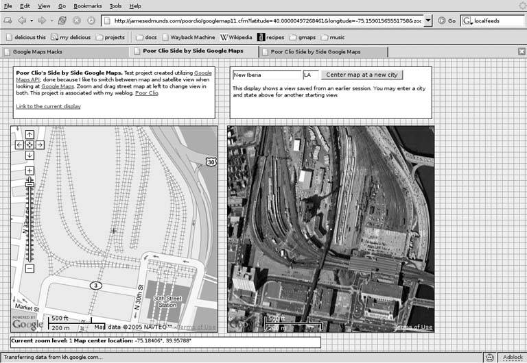
What's novel about this site is that if you drag the map on the left with your mouse, double-click to recenter it, or zoom in or out, the satellite view on the right recenters and zooms to match. Until Google introduced hybrid mode maps, this was effectively one of the only ways to compare the satellite and map views. The secret to how it works lies in the Google Maps Event API.
6.11.2. The Code
If you've written or looked at JavaScript code that uses the Google Maps API to cause info windows to pop up when the user clicks on a marker, then you've probably seen a method call that looks like this:
	GEvent.addListener(marker, "click", function( ) {
	 marker.openInfoWindowHtml(html);
	});
This method uses the GEvent class to register a click event on a marker object. When the marker is clicked, the anonymous function gets called, and the info window is opened. As it happens, the Google Maps API offers several other events for tracking and responding to user interactions.
Here's a snippet of code from the Poor Clio's Side-by-Side page:
	function onMapMove( ) {
	 smap.centerAndZoom(map.getCenterLatLng( ), smap.getZoomLevel( ));
	 updateStatus( );
	}

	function onMapZoom(oldZoom, newZoom) {
	 smap.centerAndZoom(map.getCenterLatLng( ), newZoom);
	 updateStatus( );
	}

	GEvent.addListener(map, 'move', onMapMove);
	GEvent.addListener(map, 'zoom', onMapZoom);
	updateStatus( );
These dozen or so lines of JavaScript code handle virtually all of the user interactions needed to keep the two maps in sync. The first thing to note about this code is that, unlike most Google Maps API examples, you'll see two GMap objects in this code, one called map in the JavaScript, and the other called smap. Well, why not?
The first of the two functions shown above, onMapMove( ), takes the GPoint object representing the latitude and longitude of the center of the regular map, and the integer representing the current zoom level of the regular map, and passes them to the centerAndZoom( ) method of the satellite map. When this happens, the satellite map automatically zooms and recenters to match the center point and zoom level of the regular map. The onMapZoom( ) function does basically the same thing, but it takes two arguments, representing the old and new zoom levels of the regular map, and uses the new zoom level of the regular map as the new zoom level of the satellite map. The two calls to GEvent.addListener( ) hook these functions into the move and zoom events on the regular map, respectively, so that when the user changes the view of the regular map, the satellite map follows.
The calls to updateStatus( ) interspersed through the code above cause the latitude, longitude, and zoom level display below the two maps to keep in sync as well. The code looks like this:
	function updateStatus()
	{
	 var point = map.getCenterLatLng();
	 var status =
	 "Current zoom level: " + map.getZoomLevel() +
	 " Map center location: " +
	 Math.round(point.x * 100000) / 100000 + "°, " +
	 Math.round(point.y * 100000) / 100000 + "°";
	 document.getElementById("status").innerHTML = status;
	}
The use of Math.round(), coupled with multiplication and division by a constant power of ten, is a standard trick for rounding a floating-point number to a given number of decimal places. The call to document.getElementById( ) fetches the HTML Document Object Model element containing the status message, and the assignment to the innerHTML property updates the HTML inside with the latest center point and zoom.
This same kind of technique can hypothetically be used to have a "Link to this View" URL track the current view, although Poor Clio's doesn't do it that way. Assuming that you had an HTML element with an id attribute set to linkHere, you could do something like the following to update the URL in the HRef attribute:
	document.getElementById("linkHere").setAttribute( "href",
	 "http://some.server.net/gmaps?ll
	 =" + point.x + "+" + point.y + "&z=" + zoom );
There's one other trick that the Poor Clio's site uses to keep the maps in sync. Because the satellite half of this page doesn't have zoom and pan controls, the only way to move the satellite map independently is to drag it with the mouse. The site uses this line of JavaScript to keep such a thing from happening.
smap.disableDragging();
The other way to solve the problem of the maps potentially getting out of sync, of course, would be to make the event handlers a bit more generic and then add two more calls to addEventListener( ) to make the regular map follow movements on the satellite map as well.
6.11.3. The GEvent API
The key thing to note about the GEvent API is that all its methods are static, which is to say that they're called on the class itself, and not on an instance of the class. This means you say:
GEvent.addListener( … ); // RIGHT
…as opposed to the following, which you should definitely not use:
	var event = new GEvent(); // WRONG
	event.addListener( … ); // WRONG
We mention this because it may run contrary to your expectations, as most of the other classes in the Google Maps API require you to instantiate an object of that class before calling methods on it.
The GEvent API shouldn't be mistaken for the JavaScript event API, which works rather similarly, with its onClick, onMouseOver, onChange methods, and so on. In general, you'll want to use GEvent handlers for Google Maps API objects, and continue to use JavaScript event handlers for everything else. In particular, as of this writing, there isn't anything like an onMouseOver event for Google Maps marker objects, and more's the pity. Perhaps Google will fix this in a future version of its API.
6.11.4. Hacking the Hack
Most Google Maps hacks out there rely on an Update Map button (or the equivalent) to update the overlays on a map after the user zooms or pans. This definitely works, but it's not the most elegant solution for refreshing the map's contents, because it relies on the user to do something that could be done automatically in JavaScript.
However, before you run out and add event handlers to your Google Map, consider the following: the Google Maps API doesn't guarantee exactly when the registered event handlers will be called, just that they will be called at some point. If you try dragging the regular map around on the Poor Clio's site, you'll notice that there's sometimes a bit of lag, but (assuming you don't drag too quickly) the satellite map otherwise follows along pretty faithfully. This means that the move event on the regular map is getting triggered every so many seconds or milliseconds throughout the drag.
If your intention is to have one map track another, this is definitely what you want to have happen. On the other hand, if you're using the event handler to trigger a download of fresh data off the network, you probably don't want to have multiple overlapping data requests slowing everything down while the user is still trying to drag the map.
First, this means you want to use the moveend event with the GMap object, and not the move event. However, if you really want to be on the safe side, you might do well to combine this with a semaphore and a delay, in case the user does a bit of fine adjustment to recenter or zoom the map to exactly what they want to see. Here's what the code might look like:
	var updateRequested = 0;

	GEvent.addListener( map, "moveend", function() {
	 updateRequested++;
	 window.setTimeout( beginUpdate, 2500 )
	});

	function beginUpdate () {
	 if (--updateRequested > 0) return;
	 // *now* check map.getCenterLatLng() etc.
	 // then launch a new GXmlHttp request
	 // and do the update handling when the request is complete
	}
The use of the global updateRequested variable acts as a semaphore to keep multiple events from triggering multiple network updates that would then stomp all over each other. When a moveend event is triggered, updateRequested is incremented from zero to one, and the network update is scheduled to begin 2,500 milliseconds (i.e., 2.5 seconds) later. In the meantime, further moveend events will increment updateRequested by 1 each time. When beginUpdate( ) gets called 2.5 seconds after the first moveend event, it will decrement updateRequested by 1, and then check to see if the semaphore is still greater than zero. If it is, then subsequent movements of the map must have occurred in the meantime, and the update is therefore deferred.
Finally, the last beginUpdate( ) will trigger 2.5 seconds after last moveend event, at which point the user has stopped moving the map around, the updateRequested semaphore will be decremented back to zero and, then and only then, the update will occur. Choosing the right delay so that network updates are smooth and non-overlapping, but so that the user experience isn't too terribly degraded, is probably a matter that merits some experimentation.
You Are Here: Introducing Google Maps
- Hacks 19: Introduction
- Hack 1. Get Around http://maps.google.com
- Hack 2. Find Yourself (and Others) on Google Maps
- Hack 3. Navigate the World in Your Web Browser
- Hack 4. Get the Birds-Eye View
- Hack 5. Driven to a Better User Interface
- Hack 6. Share Google Maps
- Hack 7. Inside Google Maps URLs
- Hack 8. Generate Links to Google Maps in a Spreadsheet
- Hack 9. Use del.icio.us to Keep Up with Google Maps
Introducing the Google Maps API
- Hacks 1016: Introduction
- Hack 10. Add a Google Map to Your Web Site
- Hack 11. Where Did the User Click?
- Hack 12. How Far Is That? Go Beyond Driving Directions
- Hack 13. Create a Route with a Click (or Two)
- Hack 14. Create Custom Map Markers
- Hack 15. Map a Slideshow of Your Travels
- Hack 16. How Big Is the World?
Mashing Up Google Maps
- Hacks 1728: Introduction
- Hack 17. Map the News
- Hack 18. Examine Patterns of Criminal Activity
- Hack 19. Map Local Weather Conditions
- Hack 20. Track Official Storm Reporting
- Hack 21. Track the International Space Station
- Hack 22. Witness the Effects of a Nuclear Explosion
- Hack 23. Find a Place to Live
- Hack 24. Search for Events by Location
- Hack 25. Track Your UPS Packages
- Hack 26. Follow Your Packets Across the Internet
- Hack 27. Add Google Maps to Any Web Site
- Hack 28. How Big Is That, Exactly?
On the Road with Google Maps
- Hacks 2941: Introduction
- Hack 29. Find the Best Gasoline Prices
- Hack 30. Stay Out of Traffic Jams
- Hack 31. Navigate Public Transportation
- Hack 32. Locate a Phone Number
- Hack 33. Why Your Cell Phone Doesnt Work There
- Hack 34. Publish Your Own Hiking Trail Maps
- Hack 35. Load Driving Directions into Your GPS
- Hack 36. Get Driving Directions for More Than Two Locations
- Hack 37. View Your GPS Tracklogs in Google Maps
- Hack 38. Map Your Wardriving Expeditions
- Hack 39. Track Your Every Move with Google Earth
- Hack 40. The Ghost in Google Ride Finder
- Hack 41. How Google Maps Got Me Out of a Traffic Ticket
Google Maps in Words and Pictures
- Hacks 4250: Introduction
- Hack 42. Get More out of What You Read
- Hack 43. Dont Believe Everything You Read on a Map
- Hack 44. You Got Your A9 Local in My Google Maps!
- Hack 45. Share Pictures with Your Community
- Hack 46. Browse Photography by Shooting Location
- Hack 47. Geotag Your Own Photos on Flickr
- Hack 48. Tell Your Communitys Story
- Hack 49. Generate Geocoded RSS from Any Google Map
- Hack 50. Geoblog with Google Maps in Thingster
API Tips and Tricks
- Hacks 5161: Introduction
- Hack 51. Make a Fullscreen Map the Right Way
- Hack 52. Put a Map and HTML into Your Info Windows
- Hack 53. Add Flash Applets to Your Google Maps
- Hack 54. Add a Nicer Info Window to Your Map with TLabel
- Hack 55. Put Photographs on Your Google Maps
- Hack 56. Pin Your Own Maps to Google Maps with TPhoto
- Hack 57. Do a Local Zoom with GxMagnifier
- Hack 58. Find the Right Zoom Level
- Hack 59. Show Lots of StuffQuickly
- Hack 60. Make Things Happen When the Map Moves
- Hack 61. Use the Right Developers Key Automatically
Extreme Google Maps Hacks
- Hacks 6270: Introduction
- Hack 62. Find the Latitude and Longitude of a Street Address
- Hack 63. Read and Write Markers from a MySQL Database
- Hack 64. Build Custom Icons on the Fly
- Hack 65. Add More Imagery with a WMS Interface
- Hack 66. Add Your Own Custom Map
- Hack 67. Serve Custom Map Imagery
- Hack 68. Automatically Cut and Name Custom Map Tiles
- Hack 69. Cluster Markers at High Zoom Levels
- Hack 70. Will the Kids Barf? (and Other Cool Ways to Use Google Maps)
EAN: 2147483647
Pages: 131
