Hack 21. Track the International Space Station


Track the International Space Station and the Space Shuttle in near-real time.
You can track anything on Google Mapsall you need is a source of data. Tom Mangan created his own site to track the Space Shuttle and International Space Station (ISS) at http://gmaps.tommangan.us/spacecraft_tracking.html.
The site tracks the location of the ISS and, when it is in orbit, the Space Shuttle, as shown in Figure 3-11. The excitement can come from being able to spot the Shuttle and ISS from the ground, and in watching on the map as they rendevous. When you first load the page you should get one or two markers, depending on whether the Shuttle is in orbit. If you leave the page open the markers leave a trail of where the ISS and Shuttle have been. Over the course of about 90 minutes (actually, 91.55 minutes for the ISS, according to the Wikipedia page at http://en.wikipedia.org/wiki/International_Space_Station), the characteristic sine wave shape of low Earth orbits appears. No, objects in space don't bounce around like tennis balls; this represents the effects of representing a three dimensional orbit onto a flat map. The first rule of cartography is that you always distort something!
Figure 3-11. Shuttle and ISS tracking, with an amusing note
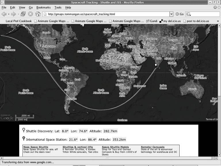
Google's AdSense ads are often the funniest part of a page. Here we have a link to "NASA Space Shuttle for sale. Check out the deals now!" I don't think I want to buy an affordable spacecraft on eBay! Maybe in a few years.
3.6.1. How It Works
Most of the work happens in the JavaScript in the site's autoUpdate( ) function. autoUpdate( ) is called as soon as the page loads.
The autoUpdate function uses the GXmlHttp class from Google Maps to fetch the iss.js file from the server. You can take a look at the file at http://gmaps.tommangan.us/iss.js.
-48.6;-11.7;369.8;-51.6;-31.9;291.1
This shows the latitude and longitude of the ISS first, and then that of the shuttle. The code reads the file, then splits the results into the array coords with the split method. The rest of the method is housekeeping to do a sanity check on the returned result, then adds the points to the current arrays of results for the Shuttle and ISS.
	function autoUpdate() {
	 var request = GXmlHttp.create();
	 request.open("GET", "iss.js", true);
	 request.onreadystatechange = function() {
	 if (request.readyState == 4) {
	 var response = request.responseText;
	 coords = response.split(';');
	 var valid = (coords[0]&&coords[1]&&coords[3]&&coords[4]
	 &&coords[0]>-90&&coords[0]<90&&coords[1]>-180
	 &&coords[1]<180&&coords[3]>-90&&coords[3]<90
	 &&coords[4]>-180&&coords[4]<180);

	 if (valid) {
	 map.clearOverlays();
	 var sPoint = new GPoint (coords[4],coords[3]);
	 var sMarker = new GMarker (sPoint,pinWhite);
	 if (coords[4] < -174) { sTrack=[]; }
	 sTrack.push (sPoint);
	 map.addOverlay(sMarker);

	 var issPoint = new GPoint (coords[1],coords[0]);
	 var issMarker = new GMarker (issPoint,pinRed);
	 if (coords[1] < -174) { issTrack=[]; }
	 issTrack.push (issPoint);
	 map.addOverlay(issMarker);

	 refreshCoords();
	 drawTrack();
	 }
	 }
	 }
	 request.send(null);
	 window.setTimeout ('autoUpdate()', 60000);
	}
The final trick is the last line of autoUpdate():
window.setTimeout ('autoUpdate()', 60000);
This tells the window to timeout after 60,000 milliseconds, i.e., one minute. When it times out it calls autoUpdate() and starts the cycle again.
There is a script running on the server that queries the NASA site for the current position of the Shuttle and ISS, and then writes that out the iss.js file. You can use these same techniques to do dynamic updating of your own maps.
If you are the sort of person who goes in for space shuttle tracking, you'll like a couple of Tom's other projects at http://gmaps.tommangan.us/. He has a map that shows the current known locations of all of the SR 71 Blackbirds and aerial photos of Area 51. Both projects use his TPhoto extension to the Google Maps API, which lets you embed your own images within Google Maps [Hack #55].
3.6.2. See Also
- NASA's Satellite Tracking Page, which includes applications to track many different satellites, although not with Google Maps: http://science.nasa.gov/realtime/.
You Are Here: Introducing Google Maps
- Hacks 19: Introduction
- Hack 1. Get Around http://maps.google.com
- Hack 2. Find Yourself (and Others) on Google Maps
- Hack 3. Navigate the World in Your Web Browser
- Hack 4. Get the Birds-Eye View
- Hack 5. Driven to a Better User Interface
- Hack 6. Share Google Maps
- Hack 7. Inside Google Maps URLs
- Hack 8. Generate Links to Google Maps in a Spreadsheet
- Hack 9. Use del.icio.us to Keep Up with Google Maps
Introducing the Google Maps API
- Hacks 1016: Introduction
- Hack 10. Add a Google Map to Your Web Site
- Hack 11. Where Did the User Click?
- Hack 12. How Far Is That? Go Beyond Driving Directions
- Hack 13. Create a Route with a Click (or Two)
- Hack 14. Create Custom Map Markers
- Hack 15. Map a Slideshow of Your Travels
- Hack 16. How Big Is the World?
Mashing Up Google Maps
- Hacks 1728: Introduction
- Hack 17. Map the News
- Hack 18. Examine Patterns of Criminal Activity
- Hack 19. Map Local Weather Conditions
- Hack 20. Track Official Storm Reporting
- Hack 21. Track the International Space Station
- Hack 22. Witness the Effects of a Nuclear Explosion
- Hack 23. Find a Place to Live
- Hack 24. Search for Events by Location
- Hack 25. Track Your UPS Packages
- Hack 26. Follow Your Packets Across the Internet
- Hack 27. Add Google Maps to Any Web Site
- Hack 28. How Big Is That, Exactly?
On the Road with Google Maps
- Hacks 2941: Introduction
- Hack 29. Find the Best Gasoline Prices
- Hack 30. Stay Out of Traffic Jams
- Hack 31. Navigate Public Transportation
- Hack 32. Locate a Phone Number
- Hack 33. Why Your Cell Phone Doesnt Work There
- Hack 34. Publish Your Own Hiking Trail Maps
- Hack 35. Load Driving Directions into Your GPS
- Hack 36. Get Driving Directions for More Than Two Locations
- Hack 37. View Your GPS Tracklogs in Google Maps
- Hack 38. Map Your Wardriving Expeditions
- Hack 39. Track Your Every Move with Google Earth
- Hack 40. The Ghost in Google Ride Finder
- Hack 41. How Google Maps Got Me Out of a Traffic Ticket
Google Maps in Words and Pictures
- Hacks 4250: Introduction
- Hack 42. Get More out of What You Read
- Hack 43. Dont Believe Everything You Read on a Map
- Hack 44. You Got Your A9 Local in My Google Maps!
- Hack 45. Share Pictures with Your Community
- Hack 46. Browse Photography by Shooting Location
- Hack 47. Geotag Your Own Photos on Flickr
- Hack 48. Tell Your Communitys Story
- Hack 49. Generate Geocoded RSS from Any Google Map
- Hack 50. Geoblog with Google Maps in Thingster
API Tips and Tricks
- Hacks 5161: Introduction
- Hack 51. Make a Fullscreen Map the Right Way
- Hack 52. Put a Map and HTML into Your Info Windows
- Hack 53. Add Flash Applets to Your Google Maps
- Hack 54. Add a Nicer Info Window to Your Map with TLabel
- Hack 55. Put Photographs on Your Google Maps
- Hack 56. Pin Your Own Maps to Google Maps with TPhoto
- Hack 57. Do a Local Zoom with GxMagnifier
- Hack 58. Find the Right Zoom Level
- Hack 59. Show Lots of StuffQuickly
- Hack 60. Make Things Happen When the Map Moves
- Hack 61. Use the Right Developers Key Automatically
Extreme Google Maps Hacks
- Hacks 6270: Introduction
- Hack 62. Find the Latitude and Longitude of a Street Address
- Hack 63. Read and Write Markers from a MySQL Database
- Hack 64. Build Custom Icons on the Fly
- Hack 65. Add More Imagery with a WMS Interface
- Hack 66. Add Your Own Custom Map
- Hack 67. Serve Custom Map Imagery
- Hack 68. Automatically Cut and Name Custom Map Tiles
- Hack 69. Cluster Markers at High Zoom Levels
- Hack 70. Will the Kids Barf? (and Other Cool Ways to Use Google Maps)
EAN: 2147483647
Pages: 131
- Challenging the Unpredictable: Changeable Order Management Systems
- The Second Wave ERP Market: An Australian Viewpoint
- Enterprise Application Integration: New Solutions for a Solved Problem or a Challenging Research Field?
- Distributed Data Warehouse for Geo-spatial Services
- Healthcare Information: From Administrative to Practice Databases
