Hack 12. How Far Is That? Go Beyond Driving Directions


Draw routes and calculate distances on your own Google Maps.
How far is it? That's a basic question we often ask of maps. Google Maps' driving directions answer that question, but driving directions are not (yet) accessible to the developer's API. More importantly, they simply give driving distances assuming the optimal route, where optimal is defined as getting there as quickly as possible in an automobile. They are not optimized for "scenic drive" or "safest bicycle route" or "quiet stroll" or "jog around the park."
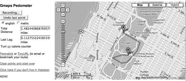
There are at least two sites that allow you to create routes and calculate distances by clicking on maps. The Gmaps Pedometer at http://www.sueandpaul.com/gmapPedometer/ shown in Figure 2-6 estimates cumulative distanceand even includes a calorie counter.
Use the standard map controls to zoom into your area of interest, and then click Start Recording. When you double-click a point on the map, it will recenter to that spot and add a marker there. The second time you click, the map will recenter to your new point, the marker will be moved, and a line will be drawn from the last point clicked to this one. Each time you do this, the Total Distance and Last Leg Distance fields will be updated.
Figure 2-6. Sue and Paul's Gmaps Pedometer
Handling double clicks is a bit awkward and browser dependent. Sue and Paul are doing browser detection and then setting the appropriate event handler based on the browser:
	if (navigator.appName == 'Microsoft Internet Explorer'){
	 document.ondblclick = handleDblClick;
	 bIsIE = true;

	 } else {
	 window.ondblclick = handleDblClick;
	 bIsIE = false;
	 }
Do you see the difference between the two ondblclick events? It is a difference in how they implement the Document Object Model. Internet Explorer handles double-clicks at the document level, hence document.ondblclick and everyone else (well, everyone else according to this code) uses the window object, so window.ondblclick. In both cases when there is a double-click the variable bDoubleClickHappened is set to true.
This will become important in a bit. You can't add a double-click listener with the Google Maps API, so the map does not directly capture the double-click event, but rather the moveend event, which according to the API documentation is "Triggered at the end of a discrete or continuous map movement. This event is triggered once at the end of a continuous pan."
This means that when there is a double-click event, Sue and Paul's handleDblClick function is called to set the bDoubleClickHappened variable. Next the Google Maps equivalent of handleDblClick is called.
Once Google Maps has finished the move or pan, the moveend event is triggered, the function set to listen for moveend events is called, and the anonymous function set in this code is called:
	GEvent.addListener(map, "moveend", function() {
	 if (bDoubleClickHappened){
	 addLeg(map.getCenterLatLng().x, map.getCenterLatLng().y);
	 drawPolyLine(gPointArray);
	 }
	 bDoubleClickHappened = false;
	});
I love this code! It is an example of not always getting what you want, but finding a way to get what you need. We don't want to add a leg to our route on every move, just the ones that were initiated by a double-click. When the double-click handler was called, the bDoubleClickHappened variable was set. This code is called any time the map is moved, and if the map was double-clicked the addLeg and drawPolyLine functions are called.
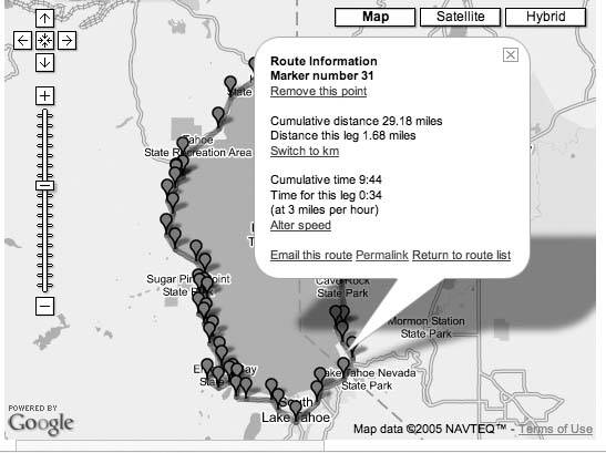
Walk Jog Run, shown in Figure 2-7, works in similar ways, but it captures single clicks. If you click on the map it asks if you want to start a new route. If you say yes, it captures each click, adds a marker, and draws a line connecting all of the points you've clicked.
Figure 2-7. Walk Jog Run
If this is the first click, the route will be empty, so startRoute() is called; otherwise, this is the continuation of a route, so this point is added to the list.
	GEvent.addListener(map, 'click', function(overlay, point) {
	 if (overlay) {
	 /* do nothing */
	 } else if (point) {
	 if (route.length == 0) {
	 startRoute(point);
	 } else if (route[route.length-1].x != point.x ||
	 route[route.length-1].y != point.y) {
	 route.push(point);
	 currentRouteId = null;
	 drawRoute(route);
	 }
	 }
	 });
The prototype for a click event handler accepts an overlay and point parameter. The overlay parameter is set when the user clicks on an overlay (that is, a line or marker). Most of the time we handle click events on markers by setting a listener when the marker is created. The drawRoute method is called when a new point is added and then goes through the list of points in the route, setting up the text for the marker overlays and calling this createMarker code to draw them, and then drawing the polyline of the route.
	function createMarker(point, mtext, icon) {
	 var marker = new GMarker(point,icon);
	 var html = "Route Information
" + mtext;
	 GEvent.addListener(marker, "click", function() {
	 currentPoint = marker.point;
	 map.centerAndZoom(currentPoint, map.getZoomLevel());
	 marker.openInfoWindowHtml(html);
	 });
	 return marker;
	}
This illustrates the creation of a marker with embedded text. If you want your markers to open, add a listener for the click event of the marker. The standard choice when clicking a marker is the openInfoWindowHTML() method for the marker. This pops up the standard HTML-enabled info window, but you can do anything when a marker is called.
|

Walk Jog Run aims to be the http://del.icio.us of maps for the running community. It lets you save your own routes as well as search and comment on the shared list of routes. You can look at the information relevant to any of the intermediate points on the route. Walk Jog Run shows you an estimated time for the total route and for each segment and allows you to delete any points from a route, unlike Sue and Paul's, which will only let you undo the last point.
Lines or Points? Both services let you add points by clicking. GMaps Pedometer shows a marker for your start and most recent position and hides the markers for the intermediate points. The result is a clean path overlaid on the map. Walk Jog Run leaves the markers on the map, which lets you view statistics for each segment of a completed route. They each have advantages.
Both GMaps Pedometer and Walk Jog Run aim to be full-featured sites. As a result, the code has a lot of detail that might make it hard to understand what is going on. Our page at http://mappinghacks.com/projects/gmaps/lines.html has another example of adding markers and lines, and then calculating distances in response to click events, as shown in Figure 2-8.
Figure 2-8. Adding markers and lines
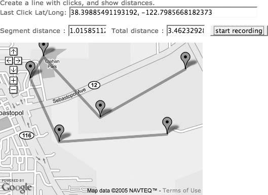
When the user clicks on the Start Recording button, the code sets up a listener to process click events and the recording_flag is set in the JavaScript. If it is set the current position is added to the arrays that hold our x and y positions (where, you'll recall x equals longitude, and y equals latitude), and the drawRoute function is called. Finally, the current latitude and longitude are shown in the form elements click_lat and click_long. Capturing clicks is described in more detail in "Where Did the User Click?" [Hack #11].
	GEvent.addListener(map, 'click',
	 function(overlay, point) {
	 if (point) {
	 if (recording_flag > 0) {
	 addPoint(point.y, point.x, keepPoint);
	 x_array.push(point.x);
	 y_array.push(point.y);
	 drawRoute();

	 document.getElementById('click_lat').value = point.y;
	 document.getElementById('click_long').value = point.x;
	 }
	 }
	 }
	 ); // end of GEvent.addListener
The drawRoute( ) function is a bit longer, but hopefully straightforward. The first trick when updating markers is to clear all the existing markers by calling clearOverlays( ). Next the code walks the array of longitudes, x_array. Distances are calculated for the segment and the running distance of the route up to this point. The segment_distance and total_distance form elements are updated to show the distances.
The point is then created and a marker added. The created point is added to the array points. Once all of the elements in the x and y arrays have been processed, the array of points is added as a new GPolyLine.
	function drawRoute() {
	 map.clearOverlays();
	 var points = [];
	 for (i = 0; i < x_array.length; i++) {
	 if (i>0) {
	 segment_distance_array[i] = calcDist(x_array[i-1], y_array[i-1],
	 x_array[i], y_array[1]);
	 total_distance_array[i] = total_distance_array[i-1] +
	 segment_distance_array[i];
	 document.getElementById('segment_distance').value =
	 segment_distance_array[i];
	 document.getElementById('total_distance').value =
	 total_distance_array[i];
	 } else {
	 // initialize the first element distances to 0
	 document.getElementById('segment_distance').value = 0;
	 document.getElementById('total_distance').value = 0;
	 total_distance_array[0] = 0;
	 segment_distance_array[0] = 0;
	 }
	 var point = new GPoint(x_array[i], y_array[i]);
	 points.push(point);
	 var marker = new GMarker(point);

	 // define the text that appears in the marker
	 var html = "location " + y_array[i] + ', ' + x_array[i] + "";
	 GEvent.addListener(marker, "click", function() {
	 marker.openInfoWindowHtml(html);
	 });
	 map.addOverlay(marker);
	 }
	 map.addOverlay(new GPolyline(points));
	}
This is not the only, or even best, way to do this! There is more than one way to do it!
Now, let's move on to calculating distances. Walk Jog Run and GMaps Pedometer use similar functions to calculate distance. I used the one from Walk Jog Run in my demo because it specifically had a Creative Commons Attribution-NonCommercial-ShareAlike license.
	/* calcDist() function is from Adam Howitt
	 Copyright Adam Howitt 2005
	 Email: adamhowitt@gmail.com
	 This work is licensed under a Creative Commons
	 Attribution-NonCommercial-ShareAlike 2.5 License.
	 http://creativecommons.org/licenses/by-nc-sa/2.5/
	*/
	function calcDist(lon1,lat1,lon2,lat2) {
	 var r = 3963.0;
	 var multiplier = 1;
	 // var multiplier = currentUnit == "miles" ? 1 : MILESASKM;
	 return multiplier * r * Math.acos(Math.sin(lat1/57.2958) *
	 Math.sin(lat2/57.2958) + Math.cos(lat1/57.2958) *
	 Math.cos(lat2/57.2958) * Math.cos(lon2/57.2958 -
	 lon1/57.2958));
	}:
Note that the variable multiplier has been commented out. In this code, I'm displaying the values only in miles. The multiplier represents the conversion factor from miles to whatever units you need. MILESASKM is Miles as Kilometers, the number of kilometers in one mile, or 1.609344. The multiplier is set using the ternary operator. If the current unit equals miles then the multiplier is 1 (as 1 mile equals 1 mile); otherwise, it is set to the number of kilometers in a mile. You don't need to understand this formula, but if you want to learn more, see "How to calculate distance in miles from latitude and longitude" at http://www.meridianworlddata.com/Distance-Calculation.asp.
The constant 3,963 is close enough to the radius of the earth in statute miles. 57.2958 is the number of statute miles (5,280 feet, as opposed to nautical miles) in one degree of latitude anywhere, or one degree of longitude at the equator. A nautical mile is defined as 1 minute of latitude (or 1 minute of longitude at the equator).
With the multiplier code commented out, you can copy this function into your own code and calculate distances between anything. Go distance crazy!
You Are Here: Introducing Google Maps
- Hacks 19: Introduction
- Hack 1. Get Around http://maps.google.com
- Hack 2. Find Yourself (and Others) on Google Maps
- Hack 3. Navigate the World in Your Web Browser
- Hack 4. Get the Birds-Eye View
- Hack 5. Driven to a Better User Interface
- Hack 6. Share Google Maps
- Hack 7. Inside Google Maps URLs
- Hack 8. Generate Links to Google Maps in a Spreadsheet
- Hack 9. Use del.icio.us to Keep Up with Google Maps
Introducing the Google Maps API
- Hacks 1016: Introduction
- Hack 10. Add a Google Map to Your Web Site
- Hack 11. Where Did the User Click?
- Hack 12. How Far Is That? Go Beyond Driving Directions
- Hack 13. Create a Route with a Click (or Two)
- Hack 14. Create Custom Map Markers
- Hack 15. Map a Slideshow of Your Travels
- Hack 16. How Big Is the World?
Mashing Up Google Maps
- Hacks 1728: Introduction
- Hack 17. Map the News
- Hack 18. Examine Patterns of Criminal Activity
- Hack 19. Map Local Weather Conditions
- Hack 20. Track Official Storm Reporting
- Hack 21. Track the International Space Station
- Hack 22. Witness the Effects of a Nuclear Explosion
- Hack 23. Find a Place to Live
- Hack 24. Search for Events by Location
- Hack 25. Track Your UPS Packages
- Hack 26. Follow Your Packets Across the Internet
- Hack 27. Add Google Maps to Any Web Site
- Hack 28. How Big Is That, Exactly?
On the Road with Google Maps
- Hacks 2941: Introduction
- Hack 29. Find the Best Gasoline Prices
- Hack 30. Stay Out of Traffic Jams
- Hack 31. Navigate Public Transportation
- Hack 32. Locate a Phone Number
- Hack 33. Why Your Cell Phone Doesnt Work There
- Hack 34. Publish Your Own Hiking Trail Maps
- Hack 35. Load Driving Directions into Your GPS
- Hack 36. Get Driving Directions for More Than Two Locations
- Hack 37. View Your GPS Tracklogs in Google Maps
- Hack 38. Map Your Wardriving Expeditions
- Hack 39. Track Your Every Move with Google Earth
- Hack 40. The Ghost in Google Ride Finder
- Hack 41. How Google Maps Got Me Out of a Traffic Ticket
Google Maps in Words and Pictures
- Hacks 4250: Introduction
- Hack 42. Get More out of What You Read
- Hack 43. Dont Believe Everything You Read on a Map
- Hack 44. You Got Your A9 Local in My Google Maps!
- Hack 45. Share Pictures with Your Community
- Hack 46. Browse Photography by Shooting Location
- Hack 47. Geotag Your Own Photos on Flickr
- Hack 48. Tell Your Communitys Story
- Hack 49. Generate Geocoded RSS from Any Google Map
- Hack 50. Geoblog with Google Maps in Thingster
API Tips and Tricks
- Hacks 5161: Introduction
- Hack 51. Make a Fullscreen Map the Right Way
- Hack 52. Put a Map and HTML into Your Info Windows
- Hack 53. Add Flash Applets to Your Google Maps
- Hack 54. Add a Nicer Info Window to Your Map with TLabel
- Hack 55. Put Photographs on Your Google Maps
- Hack 56. Pin Your Own Maps to Google Maps with TPhoto
- Hack 57. Do a Local Zoom with GxMagnifier
- Hack 58. Find the Right Zoom Level
- Hack 59. Show Lots of StuffQuickly
- Hack 60. Make Things Happen When the Map Moves
- Hack 61. Use the Right Developers Key Automatically
Extreme Google Maps Hacks
- Hacks 6270: Introduction
- Hack 62. Find the Latitude and Longitude of a Street Address
- Hack 63. Read and Write Markers from a MySQL Database
- Hack 64. Build Custom Icons on the Fly
- Hack 65. Add More Imagery with a WMS Interface
- Hack 66. Add Your Own Custom Map
- Hack 67. Serve Custom Map Imagery
- Hack 68. Automatically Cut and Name Custom Map Tiles
- Hack 69. Cluster Markers at High Zoom Levels
- Hack 70. Will the Kids Barf? (and Other Cool Ways to Use Google Maps)
EAN: 2147483647
Pages: 131
