Hack 13. Create a Route with a Click (or Two)


You can even take Google Maps where the roads don't go.
Driving directions don't always take you where you want to go, or they may take you the wrong way. You can use a little Google Maps hack to build up your own list of points that can be saved in different formats that can be loaded into a GPS or other tool that supports the GPX standard.
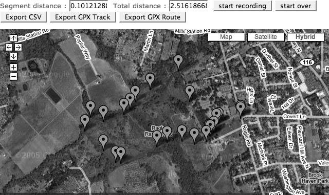
The click-to-route tool is at http://mappinghacks.com/projects/gmaps/clicktoroute.html. You click on the map to create a continuous track. An example is shown in Figure 2-9.
Figure 2-9. No roadsonly walkers, horses, and bikes here!
Once you've created your route, click on one of the Export buttons. Clicking on CSV (Comma Separated Values) generates a pure-text file with the latitude and longitude separated with commas. GPX Track makes a GPX Tracklog file. GPX Route generates a set of points that can be loaded into a GPS. Here is a sample of the route as a CSV file:
	38.4047068183193, -122.84743666648865
	38.4041771393969, -122.84764051437378
	38.403941725296505, -122.84796237945557
And here is an example of a GPX Tracklog:
Google Maps Hacks is Good
|

2.5.1. The Code
This hack is almost identical to "How Far Is That? Go Beyond Driving Directions" [Hack #12], with the addition of one function that generates the formatted list of points, and buttons to call this function. The buttons are inserted with this HTML code:
The onClick event is set to call the exportPoints function with a parameter to set the format of the exported points. This example shows the exportPoints function with the code for the GPX exports removed. The GPX format is simple XML, and that clutters up the example.
	function exportPoints(format) {
	 var export_string;
	 if (format=='csv') {
	 //csv header
	 export_string = export_string + "latitude, longitude
";
	 }

	 for (i = 0; i < x_array.length; i++) {
	 var lon = x_array[i];
	 var lat = y_array[i];
	 if (format=='csv') {

	 export_string = export_string + lat + ", " + lon + "
";
	 }
	 }

	 // write into document
	 document.getElementById("output").value=export_string;
	}
The results of your selected route will appear in a textarea below the map. You may need to scroll down to see the list. You can select the whole text area and paste it into your own document. Once you have a list of points to map back on Google Maps [Hack #37], export the points to your GPS [Hack #35], and even calculate driving directions between the points [Hack #36].
You can also use this technique to plan a trip or to explore more about a trip you took without a GPS (or a trip where the GPS didn't work because the darn satellite signals wouldn't penetrate the steel canyons of the city).
You Are Here: Introducing Google Maps
- Hacks 19: Introduction
- Hack 1. Get Around http://maps.google.com
- Hack 2. Find Yourself (and Others) on Google Maps
- Hack 3. Navigate the World in Your Web Browser
- Hack 4. Get the Birds-Eye View
- Hack 5. Driven to a Better User Interface
- Hack 6. Share Google Maps
- Hack 7. Inside Google Maps URLs
- Hack 8. Generate Links to Google Maps in a Spreadsheet
- Hack 9. Use del.icio.us to Keep Up with Google Maps
Introducing the Google Maps API
- Hacks 1016: Introduction
- Hack 10. Add a Google Map to Your Web Site
- Hack 11. Where Did the User Click?
- Hack 12. How Far Is That? Go Beyond Driving Directions
- Hack 13. Create a Route with a Click (or Two)
- Hack 14. Create Custom Map Markers
- Hack 15. Map a Slideshow of Your Travels
- Hack 16. How Big Is the World?
Mashing Up Google Maps
- Hacks 1728: Introduction
- Hack 17. Map the News
- Hack 18. Examine Patterns of Criminal Activity
- Hack 19. Map Local Weather Conditions
- Hack 20. Track Official Storm Reporting
- Hack 21. Track the International Space Station
- Hack 22. Witness the Effects of a Nuclear Explosion
- Hack 23. Find a Place to Live
- Hack 24. Search for Events by Location
- Hack 25. Track Your UPS Packages
- Hack 26. Follow Your Packets Across the Internet
- Hack 27. Add Google Maps to Any Web Site
- Hack 28. How Big Is That, Exactly?
On the Road with Google Maps
- Hacks 2941: Introduction
- Hack 29. Find the Best Gasoline Prices
- Hack 30. Stay Out of Traffic Jams
- Hack 31. Navigate Public Transportation
- Hack 32. Locate a Phone Number
- Hack 33. Why Your Cell Phone Doesnt Work There
- Hack 34. Publish Your Own Hiking Trail Maps
- Hack 35. Load Driving Directions into Your GPS
- Hack 36. Get Driving Directions for More Than Two Locations
- Hack 37. View Your GPS Tracklogs in Google Maps
- Hack 38. Map Your Wardriving Expeditions
- Hack 39. Track Your Every Move with Google Earth
- Hack 40. The Ghost in Google Ride Finder
- Hack 41. How Google Maps Got Me Out of a Traffic Ticket
Google Maps in Words and Pictures
- Hacks 4250: Introduction
- Hack 42. Get More out of What You Read
- Hack 43. Dont Believe Everything You Read on a Map
- Hack 44. You Got Your A9 Local in My Google Maps!
- Hack 45. Share Pictures with Your Community
- Hack 46. Browse Photography by Shooting Location
- Hack 47. Geotag Your Own Photos on Flickr
- Hack 48. Tell Your Communitys Story
- Hack 49. Generate Geocoded RSS from Any Google Map
- Hack 50. Geoblog with Google Maps in Thingster
API Tips and Tricks
- Hacks 5161: Introduction
- Hack 51. Make a Fullscreen Map the Right Way
- Hack 52. Put a Map and HTML into Your Info Windows
- Hack 53. Add Flash Applets to Your Google Maps
- Hack 54. Add a Nicer Info Window to Your Map with TLabel
- Hack 55. Put Photographs on Your Google Maps
- Hack 56. Pin Your Own Maps to Google Maps with TPhoto
- Hack 57. Do a Local Zoom with GxMagnifier
- Hack 58. Find the Right Zoom Level
- Hack 59. Show Lots of StuffQuickly
- Hack 60. Make Things Happen When the Map Moves
- Hack 61. Use the Right Developers Key Automatically
Extreme Google Maps Hacks
- Hacks 6270: Introduction
- Hack 62. Find the Latitude and Longitude of a Street Address
- Hack 63. Read and Write Markers from a MySQL Database
- Hack 64. Build Custom Icons on the Fly
- Hack 65. Add More Imagery with a WMS Interface
- Hack 66. Add Your Own Custom Map
- Hack 67. Serve Custom Map Imagery
- Hack 68. Automatically Cut and Name Custom Map Tiles
- Hack 69. Cluster Markers at High Zoom Levels
- Hack 70. Will the Kids Barf? (and Other Cool Ways to Use Google Maps)
EAN: 2147483647
Pages: 131
