Hack 90. Crawl the Geospatial Web with RedSpider


RedSpider provides a web-based client to view Web Map Service and Web Feature Service layersgood for testing and instant gratification!
Perhaps, after reading this far, you've decided to take the plunge into the Open Geospatial Consortium web mapping standards to share your map data and let others build on your applications. [Hack #89] shows how to set up GeoServer, the OGC equivalent of the Apache web server, to publish from your existing geographic data sources, such as a PostGIS spatial database or an existing ArcInfo resource.
Now that you've published your spatial data, you want instant gratification. This is where RedSpider comes in. RedSpider (http://redspider.us/viewer/) is a Web Map Service and Web Feature Service client that works in a web browser. It's not open source, but it's free to use and is the nicest closed-source viewer available on the Web.
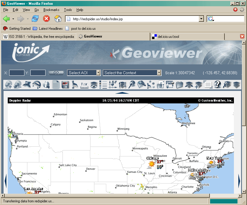
RedSpider comes preloaded with a large set of layers that represent mostly U.S.-derived global maps. There are weather reports, city names, and country outlines among the default features. However, if you just want to use RedSpider to view your own WFS/WMS published data, you probably want to turn most of these layers off. Figure 8-7 shows the U.S. feature map you see when RedSpider loads up.
Figure 8-7. A default view of RedSpider
The layer-manipulation commands on the toolbar are indicated by a stack of papers. "Manage Layers," the plain stack of paper, will allow you to inspect the vast amount of free U.S. data that RedSpider has access to.
The stack with a plus sign over it indicates "Add Layers to your Context." This is where we can add our newly published WMS or WFS data as a layer in RedSpider. Click on the "Add Layers" icon, and it will present you with an input box, where you can select a WFS or WMS to add to your view (your Context) and enter a URL.
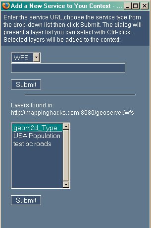
For example, we set up a simple WFS at http://mappinghacks.com:8080/wfs/geoserver that publishes a snapshot of the community wireless network in the UK, http://wirelesslondon.info. Figure 8-8 shows the list of WFS layers available from our server when we enter it into RedSpider.
Figure 8-8. RedSpider Add Layer interface
After adding a selected layer to RedSpider, hit Submit and your new data will be available in the interface. You probably won't be able to see it, though; if your data encompasses a small part of the world, the client won't be centered on it, and it may be hidden by other layers.
To recenter the view so that the bounding box, the area of space shown in the image, is the same as the bounding box of your data set, select the stack icon with two arrows protruding from it: the "Fit to Layer" option. This will recenter RedSpider's view of your data. Any new layers you've added should appear at the top of the list. Select them, and hit Submit to zoom in on your data.
The stack with an eye icon over it, "Layer Visibility," allows you to toggle on and off the layers that you want displayed on your web map. Ctrl-click to select a range of them; unselected layers will stay invisible. Again, your new layers will be at the top of the list. At the bottom of the list are layers for world countries and major cities, dating to 1998; these are always useful as a base reference.
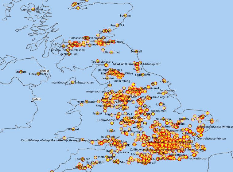
This should induce instant gratification! Figure 8-9 shows a map we were able to produce very simply with RedSpider, showing nodes on the UK community wireless network.
Figure 8-9. A map of community wireless nodes in the UK, as shown by RedSpider
WFS holds great promise in terms of being able to chain geographic data services together with no programming effort. Styled Layer Descriptor is a developing effort that will allow you to provide custom styles and symbols for map clients to display your layers with. The future is promising!
Mapping Your Life
- Hacks 1-13
- Hack 1. Put a Map on It: Mapping Arbitrary Locations with Online Services
- Hack 2. Route Planning Online
- Hack 3. Map the Places Youve Visited
- Hack 4. Find Your House on an Aerial Photograph
- Hack 5. The Road Less Traveled by in MapQuest
- Hack 6. Make Route Maps Easier to Read
- Hack 7. Will the Kids Barf?
- Hack 8. Publish Maps of Your Photos on the Web
- Hack 9. Track the Friendly Skies with Sherlock
- Hack 10. Georeference Digital Photos
- Hack 11. How Far? How Fast? Geo-Enabling Your Spreadsheet
- Hack 12. Create a Distance Grid in Excel
- Hack 13. Add Maps to Excel Spreadsheets with MapPoint
Mapping Your Neighborhood
- Hacks 14-21
- Hack 14. Make Free Maps of the United States Online
- Hack 15. Zoom Right In on Your Neighborhood
- Hack 16. Who Are the Neighbors Voting For?
- Hack 17. Map Nearby Wi-Fi Hotspots
- Hack 18. Why You Cant Watch Broadcast TV
- Hack 19. Analyze Elevation Profiles for Wireless Community Networks
- Hack 20. Make 3-D Raytraced Terrain Models
- Hack 21. Map Health Code Violations with RDFMapper
Mapping Your World
- Hacks 22-34
- Hack 22. Digging to China
- Hack 23. Explore David Rumseys Historical Maps
- Hack 24. Explore a 3-D Model of the Entire World
- Hack 25. Work with Multiple Lat/Long Formats
- Hack 26. Work with Different Coordinate Systems
- Hack 27. Calculate the Distance Between Points on the Earths Surface
- Hack 28. Experiment with Different Cartographic Projections
- Hack 29. Plot Arbitrary Points on a World Map
- Hack 30. Plot a Great Circle on a Flat Map
- Hack 31. Plot Dymaxion Maps in Perl
- Hack 32. Hack on Base Maps in Your Favorite Image Editor
- Hack 33. Georeference an Arbitrary Tourist Map
- Hack 34. Map Other Planets
Mapping (on) the Web
- Hacks 35-46
- Hack 35. Search Local, Find Global
- Hack 36. Shorten Online Map URLs
- Hack 37. Tweak the Look and Feel of Web Maps
- Hack 38. Add Location to Weblogs and RSS Feeds
- Hack 39. View Your Photo Thumbnails on a Flash Map
- Hack 40. Plot Points on a Spinning Globe Applet
- Hack 41. Plot Points on an Interactive Map Using DHTML
- Hack 42. Map Your Tracklogs on the Web
- Hack 43. Map Earthquakes in (Nearly) Real Time
- Hack 44. Plot Statistics Against Shapes
- Hack 45. Extract a Spatial Model from Wikipedia
- Hack 46. Map Global Weather Conditions
Mapping with Gadgets
- Hacks 47-63
- How GPS Works
- Hack 47. Get Maps on Your Mobile Phone
- Hack 48. Accessorize Your GPS
- Hack 49. Get Your Tracklogs in Windows or Linux
- Hack 50. The Serial Port to USB Conundrum
- Hack 51. Speak in Geotongues: GPSBabel to the Rescue
- Hack 52. Show Your Waypoints on Aerial Photos with Terrabrowser
- Hack 53. Visualize Your Tracks in Three Dimensions
- Hack 54. Create Your Own Maps for a Garmin GPS
- Hack 55. Use Your Track Memory as a GPS Base Map
- Hack 56. Animate Your Tracklogs
- Hack 57. Connect to Your GPS from Multiple Applications
- Hack 58. Dont Lose Your Tracklogs!
- Hack 59. Geocode Your Voice Recordings and Other Media
- Hack 60. Improve the Accuracy of Your GPS with Differential GPS
- Hack 61. Build a Map of Local GSM Cells
- Hack 62. Build a Car Computer
- Hack 63. Build Your Own Car Navigation System with GpsDrive
Mapping on Your Desktop
- Hacks 64-77
- Hack 64. Mapping Local Areas of Interest with Quantum GIS
- Hack 65. Extract Data from Maps with Manifold
- Hack 66. Java-Based Desktop Mapping with Openmap
- Hack 67. Seamless Data Download from the USGS
- Hack 68. Convert Geospatial Data Between Different Formats
- Hack 69. Find Your Way Around GRASS
- Hack 70. Import Your GPS Waypoints and Tracklogs into GRASS
- Hack 71. Turn Your Tracklogs into ESRI Shapefiles
- Hack 72. Add Relief to Your Topographic Maps
- Hack 73. Make Your Own Contour Maps
- Hack 74. Plot Wireless Network Viewsheds with GRASS
- Hack 75. Share Your GRASS Maps with the World
- Hack 76. Explore the Effects of Global Warming
- Conclusion
- Hack 77. Become a GRASS Ninja
Names and Places
- Hacks 78-86
- Hack 78. What to Do if Your Government Is Hoarding Geographic Data
- Hack 79. Geocode a U.S. Street Address
- Hack 80. Automatically Geocode U.S. Addresses
- Hack 81. Clean Up U.S. Addresses
- Hack 82. Find Nearby Things Using U.S. ZIP Codes
- Hack 83. Map Numerical Data the Easy Way
- Hack 84. Build a Free World Gazetteer
- Hack 85. Geocode U.S. Locations with the GNIS
- Hack 86. Track a Package Across the U.S.
Building the Geospatial Web
- Hacks 87-92
- Hack 87. Build a Spatially Indexed Data Store
- Hack 88. Load Your Waypoints into a Spatial Database
- Hack 89. Publish Your Geodata to the Web with GeoServer
- Hack 90. Crawl the Geospatial Web with RedSpider
- Hack 91. Build Interactive Web-Based Map Applications
- Hack 92. Map Wardriving (and other!) Data with MapServer
Mapping with Other People
- Hacks 93-100
- Hack 93. Node Runner
- Hack 94. Geo-Warchalking with 2-D Barcodes
- Hack 95. Model Interactive Spaces
- Hack 96. Share Geo-Photos on the Web
- Hack 97. Set Up an OpenGuide for Your Hometown
- Hack 98. Give Your Great-Great-Grandfather a GPS
- Hack 99. Map Your Friend-of-a-Friend Network
- Hack 100. Map Imaginary Places
EAN: 2147483647
Pages: 172
