Hack 55. Use Your Track Memory as a GPS Base Map


Use your own past traces to provide you with context for street navigation and low-rent GPS maps.
Newer GPS devices come with many megabytes of memory to store base maps. Companies like Garmin and MAPSource (http://mapsource.com/) sell CDs compiled from public domain data and some proprietary data to load onto your Garmin device, providing you with context for where you are: roads, names, places, and often small recommendation databases for local services.
These GPS base maps provide context and help you to navigate, but sometimes they interfere with your own story. And other times, for various reasons, there are no maps for where you are going. You can use your GPS to create your own base map out of your tracklogs and waypoints.
5.11.1. Turn Off Your Base Map to Turn On Your Own Story
Maps tell stories, and the stories that maps tell both reflect and create reality. Our experience of a place is created, or altered, through our interactions with maps. We sit surrounded by our wealth of cartographic data, and we forget ourselves and our own stories in favor of the authority of an external mapmaker.
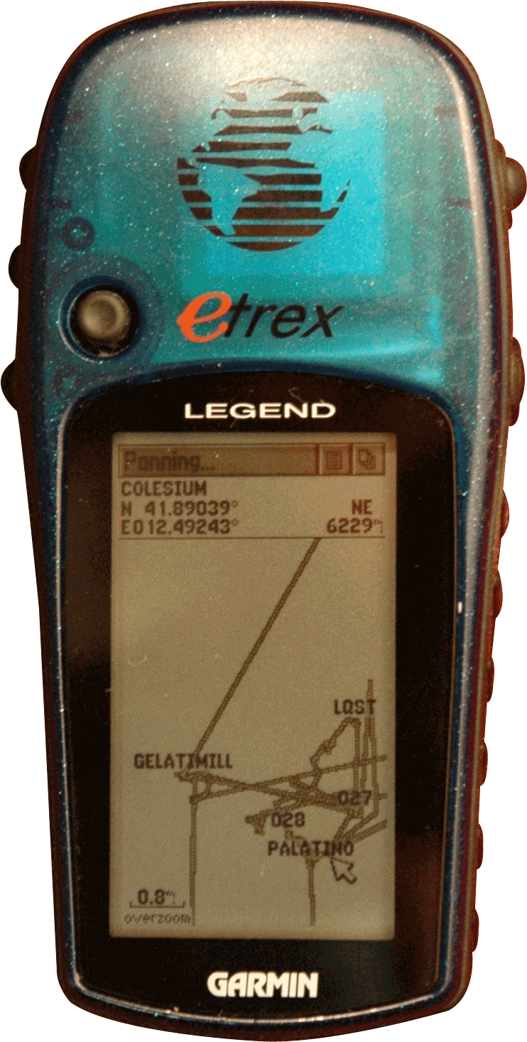
The base map in your GPS reflects (someone's) reality, but it isn't your story. You build your own story over the course of your travels. Storing tracklogs and setting waypoints provides an amazing amount of context for a mapping display. Try turning off your base maps, or setting the level of detail to the lowest setting. You are then able to fill in a huge amount of detail about the places you have been, based on your experiences and the reminders provided by your waypoints and tracklogs, as shown in Figure 5-26.
Figure 5-26. Using tracklogs as a GPS base map
We live in a phenomenal universe. This means we experience reality strictly through our senses. We don't "see" a river; rather, photons of light bounce off of the river and strike our eyes. We experience the energy of those photons, and our brains construct a reality of the river. In the same way, our experience of a place is limited to the physical phenomena that we experience: the atoms that we inhale and interpret as smells, the waves of energy we interpret as sound, the photons bouncing off of everything around us.
Since we live in a phenomenal universe, then what happens when we see a map? If that map is our first experience of a place, then our personal reality of the place is limited to what we experience from that map, plus whatever inferences we are able to make based on other contexts. For example, if you showed me a map of an "as yet unexplored by me" bit of Mexico that was near to a place I had been, I would automatically and unconsciously create an internal model of that place that included the information from the map and what I know about that part of the country from personal experience, as well as the hearsay of other travelers.
You are your own cartographer!
You might not wish to shell out for MapSource for base maps, or you might be in an area without much digital map coverage: most places outside of North America, Western Europe, and Japan. You might just enjoy the experience of trace-based map autoconstruction. This approach can be particularly fun in the places that you visit often but that are outside of your normal routine.
In the 1950s, the French Situationists realized that we tend to live our lives in ruts. In one study, they tracked the movements of a young lady in Paris over the course of a month. Her Paris was a triangle defined by her apartment, her job, and the studio of her piano teacher. In part out of reaction to this intolerable closing of mental frontiers, they created the idea of the derive as a sort of forced wandering.
Over the course of three visits to conferences in Amsterdam, I built up a comprehensive base map of street coverage of the Eastern side of Amsterdam. The experience led to serendipitous spatial exploration, too; I would decide to traverse smaller streets and take small detours so I could extend my tracklog map further in detail. In Oxford, I managed to create such a map for the center of town in a couple of afternoons. This act of forcing ourselves to engage in a task allows us to engage our goal-seeking instincts while not allowing those goal-seeking behaviors to dominate the experience. We are put into the state of forced wandering, of the derive.
On a GPS track map, especially one taken at walking or cycling pace, you find a context that is at the same level of detail as your life. Waypoints, too, provide landmarks and navigation hints, and a reassuring sense of relative distance. However, it's unusual for GPS units to store and emit timestamps with waypoints; if the temporal aspect of your travels is important to you, then you'll need to correlate your waypoints with your tracklogs after the event.
We have a friend who's collecting a "life track" for his small child, a GPS on the buggy reconstructing a narrative of where the child has been. Another friend publishes his daily life track as a geo-annotated RSS feed.
Be careful with track memory, though, if you subsequently want to download your tracks and use them to animate your journey or to geo-annotate pictures you took at the same time. When a Garmin GPS saves your track, it forgets the timestamp for each point. See [Hack #58] for the lowdown on how Garmin GPS devices store tracks, a "gotcha" that catches every GPS carrier once!
5.11.2. See Also
How can you make use of your track map outside of your own GPS? In [Hack #54], we suggest how you could make your own simple base map to load onto other Garmin devices. [Hack #51] uses the flexible GPSBabel to convert between different, custom GPS data output formats into one that different applications can work with.
Mapping Your Life
- Hacks 1-13
- Hack 1. Put a Map on It: Mapping Arbitrary Locations with Online Services
- Hack 2. Route Planning Online
- Hack 3. Map the Places Youve Visited
- Hack 4. Find Your House on an Aerial Photograph
- Hack 5. The Road Less Traveled by in MapQuest
- Hack 6. Make Route Maps Easier to Read
- Hack 7. Will the Kids Barf?
- Hack 8. Publish Maps of Your Photos on the Web
- Hack 9. Track the Friendly Skies with Sherlock
- Hack 10. Georeference Digital Photos
- Hack 11. How Far? How Fast? Geo-Enabling Your Spreadsheet
- Hack 12. Create a Distance Grid in Excel
- Hack 13. Add Maps to Excel Spreadsheets with MapPoint
Mapping Your Neighborhood
- Hacks 14-21
- Hack 14. Make Free Maps of the United States Online
- Hack 15. Zoom Right In on Your Neighborhood
- Hack 16. Who Are the Neighbors Voting For?
- Hack 17. Map Nearby Wi-Fi Hotspots
- Hack 18. Why You Cant Watch Broadcast TV
- Hack 19. Analyze Elevation Profiles for Wireless Community Networks
- Hack 20. Make 3-D Raytraced Terrain Models
- Hack 21. Map Health Code Violations with RDFMapper
Mapping Your World
- Hacks 22-34
- Hack 22. Digging to China
- Hack 23. Explore David Rumseys Historical Maps
- Hack 24. Explore a 3-D Model of the Entire World
- Hack 25. Work with Multiple Lat/Long Formats
- Hack 26. Work with Different Coordinate Systems
- Hack 27. Calculate the Distance Between Points on the Earths Surface
- Hack 28. Experiment with Different Cartographic Projections
- Hack 29. Plot Arbitrary Points on a World Map
- Hack 30. Plot a Great Circle on a Flat Map
- Hack 31. Plot Dymaxion Maps in Perl
- Hack 32. Hack on Base Maps in Your Favorite Image Editor
- Hack 33. Georeference an Arbitrary Tourist Map
- Hack 34. Map Other Planets
Mapping (on) the Web
- Hacks 35-46
- Hack 35. Search Local, Find Global
- Hack 36. Shorten Online Map URLs
- Hack 37. Tweak the Look and Feel of Web Maps
- Hack 38. Add Location to Weblogs and RSS Feeds
- Hack 39. View Your Photo Thumbnails on a Flash Map
- Hack 40. Plot Points on a Spinning Globe Applet
- Hack 41. Plot Points on an Interactive Map Using DHTML
- Hack 42. Map Your Tracklogs on the Web
- Hack 43. Map Earthquakes in (Nearly) Real Time
- Hack 44. Plot Statistics Against Shapes
- Hack 45. Extract a Spatial Model from Wikipedia
- Hack 46. Map Global Weather Conditions
Mapping with Gadgets
- Hacks 47-63
- How GPS Works
- Hack 47. Get Maps on Your Mobile Phone
- Hack 48. Accessorize Your GPS
- Hack 49. Get Your Tracklogs in Windows or Linux
- Hack 50. The Serial Port to USB Conundrum
- Hack 51. Speak in Geotongues: GPSBabel to the Rescue
- Hack 52. Show Your Waypoints on Aerial Photos with Terrabrowser
- Hack 53. Visualize Your Tracks in Three Dimensions
- Hack 54. Create Your Own Maps for a Garmin GPS
- Hack 55. Use Your Track Memory as a GPS Base Map
- Hack 56. Animate Your Tracklogs
- Hack 57. Connect to Your GPS from Multiple Applications
- Hack 58. Dont Lose Your Tracklogs!
- Hack 59. Geocode Your Voice Recordings and Other Media
- Hack 60. Improve the Accuracy of Your GPS with Differential GPS
- Hack 61. Build a Map of Local GSM Cells
- Hack 62. Build a Car Computer
- Hack 63. Build Your Own Car Navigation System with GpsDrive
Mapping on Your Desktop
- Hacks 64-77
- Hack 64. Mapping Local Areas of Interest with Quantum GIS
- Hack 65. Extract Data from Maps with Manifold
- Hack 66. Java-Based Desktop Mapping with Openmap
- Hack 67. Seamless Data Download from the USGS
- Hack 68. Convert Geospatial Data Between Different Formats
- Hack 69. Find Your Way Around GRASS
- Hack 70. Import Your GPS Waypoints and Tracklogs into GRASS
- Hack 71. Turn Your Tracklogs into ESRI Shapefiles
- Hack 72. Add Relief to Your Topographic Maps
- Hack 73. Make Your Own Contour Maps
- Hack 74. Plot Wireless Network Viewsheds with GRASS
- Hack 75. Share Your GRASS Maps with the World
- Hack 76. Explore the Effects of Global Warming
- Conclusion
- Hack 77. Become a GRASS Ninja
Names and Places
- Hacks 78-86
- Hack 78. What to Do if Your Government Is Hoarding Geographic Data
- Hack 79. Geocode a U.S. Street Address
- Hack 80. Automatically Geocode U.S. Addresses
- Hack 81. Clean Up U.S. Addresses
- Hack 82. Find Nearby Things Using U.S. ZIP Codes
- Hack 83. Map Numerical Data the Easy Way
- Hack 84. Build a Free World Gazetteer
- Hack 85. Geocode U.S. Locations with the GNIS
- Hack 86. Track a Package Across the U.S.
Building the Geospatial Web
- Hacks 87-92
- Hack 87. Build a Spatially Indexed Data Store
- Hack 88. Load Your Waypoints into a Spatial Database
- Hack 89. Publish Your Geodata to the Web with GeoServer
- Hack 90. Crawl the Geospatial Web with RedSpider
- Hack 91. Build Interactive Web-Based Map Applications
- Hack 92. Map Wardriving (and other!) Data with MapServer
Mapping with Other People
- Hacks 93-100
- Hack 93. Node Runner
- Hack 94. Geo-Warchalking with 2-D Barcodes
- Hack 95. Model Interactive Spaces
- Hack 96. Share Geo-Photos on the Web
- Hack 97. Set Up an OpenGuide for Your Hometown
- Hack 98. Give Your Great-Great-Grandfather a GPS
- Hack 99. Map Your Friend-of-a-Friend Network
- Hack 100. Map Imaginary Places
EAN: 2147483647
Pages: 172
