Hack 53. Visualize Your Tracks in Three Dimensions


With free Windows software and a little tweaking, you can make nice 3-D models of your outdoor perambulations.
Wouldn't it be nice if you could get a better feeling for the terrain you just crossed or the magnificent view you saw earlier? Wouldn't you like to be able to do something with all of those tracklog files you've been collecting?
Wissenbach Map3D is a GPL-licensed Windows application that reads tracklogs in GPX format and then plots them over aerial photos and three-dimensional terrain models. 3DEM is a Windows program that allows you to quickly explore elevation models in many different formats and to overlay images on these terrain models. You can also export views and terrain models, and create fly-by animations. One of the best parts about it is that it "just works" to open and display digital elevation model (DEM) files.
5.9.1. Loading the Example
Wissenbach Map3D is available at http://www.gpstrailmaps.com/map3d/. Download http://www.gpstrailmaps.com/map3d/SetupYosemite3D.exe to get a copy of the program with sample data from Yosemite National Park in California.
Following the instructions in the Readme file, you can open the sample GPX file by going to the File menu and selecting Yosemite.gpx. A Map Description dialog will load; you can just click OK. Wissenbach Map3D will then attempt to fetch the aerial photography for Yosemite from Microsoft's Terraserver service so you'll need to be connected to the Internet. When it's done, you should see tracklogs and waypoints from that GPX file displayed over the aerial photography. Neat, huh? You ain't seen nothing yet!
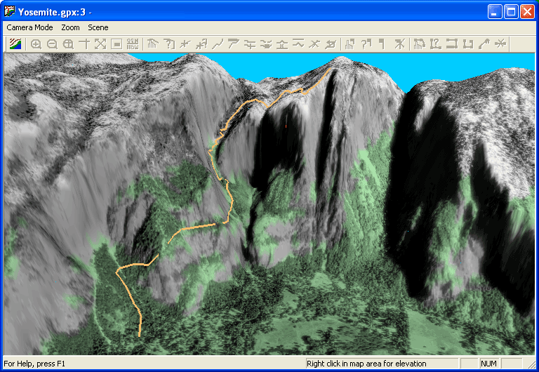
Now, click the 3DMap option from the menu bar at the top, which loads the Scene Properties dialog. Although we recommend experimenting with this on your own, for now just click OK. The program will take a minute or so to render the scene, and then it will display a 3-D model of Yosemite Valley! You can then "fly through" the Yosemite Valley by selecting Camera Mode images/ent/U2192.GIF border=0> Slide. Navigate through the valley by dragging the mouse. Figure 5-9 shows one view of the sample track snaking up the side of the valley. Speaking as one who has spent time navigating that valley on foot, using the mouse is much quicker!
Figure 5-9. The Yosemite Falls trail shown in Wissenbach Map3D
5.9.2. Loading Your Own Data
Once you tire of exploring Yosemite you can load Digital Raster Graphics (DRGs) and Digital Elevation Models (DEMs) for your own area. Since sources of data vary, you'll want to follow the instructions provided by the source's web site.
Once you start the program, you need to set an "area of interest." You can do this in one of three ways. Select View images/ent/U2192.GIF border=0> Pick Center to manually enter a point to be the center of your map. Alternatively, you can connect a GPS to your system and read points directly, or you can load a waypoint from a GPX file.
If you open a GPX file, the program will fetch aerial photos or topo maps from Terraserver and plot your tracklog over the image, once you're zoomed in close enough. You can select a USGS topographic base map (i.e., a DRG) with File images/ent/U2192.GIF border=0> JPG Topo Basemap, or an aerial photo base map with File
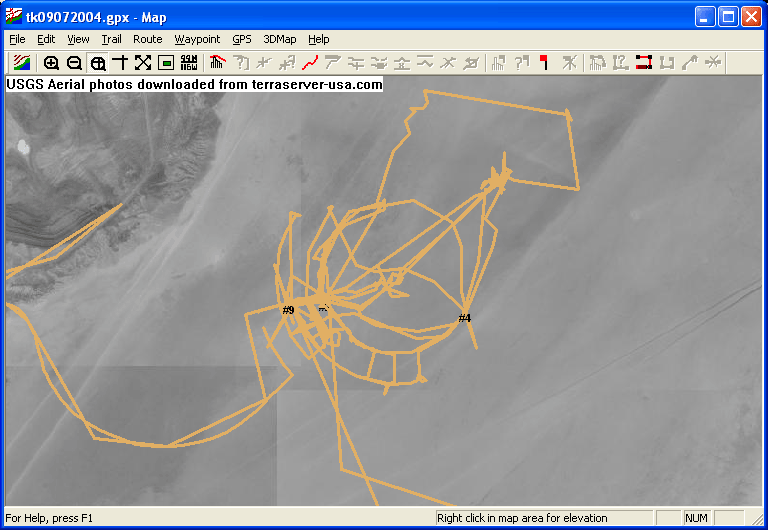
images/ent/U2192.GIF border=0> JPG Photo Basemap. Figure 5-10 shows a GPX tracklog from Black Rock City, Nevada laid over an aerial photo automatically downloaded from Terraserver.
Figure 5-10. A tracklog from Burning Man shown over an aerial photo
5.9.3. Loading New Elevation Models
Wissenbach Map3D uses USGS DEM files, each of which covers a seven-minute named quadrangle (about 8 miles by 6.5 miles) at a resolution of one arc second (~30m) or one-third arc second (~10m). The 30-meter DEMs are plenty good enough to experiment with at first, and they involve downloading a lot less data than the 10-meter DEMs. Later, if you really get into playing with digital elevation models, you can go back and get the 10-meter DEMs.
The GeoCommunity's GIS Data Depot hosts free DEM data sets for the USGS at http://data.geocomm.com/dem/demdownload.html. The DEM files are organized by state and county. To figure out exactly which quadrangles you'll need, though, you can search the USGS Geographic Names Information System (GNIS) by place name at http://geonames.usgs.gov/. Alternatively, you can search for quad names on an interactive map by visiting the USGS Geospatial Data Availability site at http://statgraph.cr.usgs.gov/. Once you find the quads you want in the GIS Data Depot download listing, you'll notice a seven-character unit code like 38122f7 in parentheses next to the quadrangle name; make a note of this, because you'll need it later.
|

At this point, you should be able to download one or more compressed DEM files from the GIS Data Depot. Unfortunately, these datafiles are in the much-reviled Spatial Data Transfer Standard (SDTS) format, so we'll have to convert them back to the USGS's native DEM format for Wissenbach Map3D to make use of them. Start by extracting the DEM from the TAR.GZ archive using WinZip, or any archive utility of your choosing. The names of the .DDF files inside will start with a four-digit number, like 8505. Make a note of this as well.
Next, fetch the sdts2dem utility from http://www.cs.arizona.edu/topovista/sdts2dem/ and simply run it from the DOS command line. You'll see a series of prompts as follows:
Enter first 4 charcters of the base SDTS file name: 8505
Enter base output file name (exclude any extension): o38122f7
Enter in the four-digit SDTS filename prefix, followed by the USGS quadrangle unit code prefixed by the letter o. You should be able to copy this into your Wissenbach DEM directory, which is defined under File images/ent/U2192.GIF border=0> DRG, DEM Directories. Wissenbach Map3D should now be able to make use of your new elevation models.
|
Wissenbach has stated plans to extend the program to use elevation data loaded from [Hack #67], which would make this process a whole lot easier, so stay tuned.
5.9.4. Adding Elevation to a Tracklog
In addition to providing nice visualizations, Wissenbach Map3D solves the tricky problem of adding elevation data to a tracklog. While many modern GPS units log elevation as you go, others do not. You can get the elevation of your track points ex post facto by using Perl, Python, or perhaps a bit of GRASS to look up the elevation of each point in a slew of DEMs, SRTM data, or GTOPO30, etc. This involves enough scripting and tedium that it almost isn't worth documentingat least now it isn't, since Wissenbach Map3D solves the problem with a nice GUI!
The program allows you to load tracklogs from GPX files, and it also allows you to create GPX files by drawing over the map in the display window. You can then add altitude to the new or loaded tracklog.
Select a "Trail" (e.g., a tracklog) with Edit images/ent/U2192.GIF border=0> Select Trail, and then click on the tracklog. Then select Trail
images/ent/U2192.GIF border=0> Trail Properties. Click on the checkbox labeled "Ground Trail to DEM Elevation," and then click OK. That is all you need to do. Assuming you have loaded the proper DEMs, the program will add elevation to your tracklog. You can now select File
images/ent/U2192.GIF border=0> Save to save this tracklog with elevation data included and use that tracklog in other programs that use elevation.
5.9.5. Hacking the Maps
Since DRGs are images in TIFF or JPEG format, you can edit the images and create your own views of the data. Download a DRG that covers your area, make a copy of it, and then load it into an image editor, such as Photoshop or the GIMP. If you save your customized image in a PNG file, you can retain the original DRG as the TIFF image. Alternatively, create a new layer, set the opacity to 50%, and use the base layer as a guide to your own creation!
5.9.6. Three-Dimensional Terrain Models in 3DEM
While Wissenbach Map3D is great at combining tracklogs and elevation models, it can be a bit of a challenge to work with if all you want to do is render 3-D scenery. For that, try 3DEM, a fantastic piece of free software for Windows.
3DEM has some features in common with Wissenbach Map3D, but Wissenbach assumes that you know where you want to explore and that you have already downloaded the relevant elevation data. This makes Wissenbach more "transparent" at letting you follow a tracklog, while 3DEM is much easier to use to explore the DEMs that you have downloaded.
3DEM can be found on the Web at http://www.visualizationsoftware.com/3dem.html. The download page includes links to digital elevation models (including DEMs of Mars!) and a helpful tutorial on finding additional DEMs on the Web.
3DEM has other features, including the ability to save virtual-reality markup language (VRML), save worlds, create fly-by animations, and it can even be used to orthorectify ground images.
Like Wissenbach Map3D, you can load tracklogs into 3DEM for display on the map. A nice feature is that if you do not have the altitude for your track points, it will be automatically added when you save the file. The downside is that 3DEM is a tad particular about the tracklog format it will accept. The 3DEM tracklog format is simple:
lat long elevation
But if you don't have an elevation you must include a 0 for your elevation field. This makes it a bit harder to load your own tracklogs. If you have gpsbabel [Hack #51] , you can convert your GPX format tracklogs to 3DEM format using this gpsbabel stylesheet. Save this as 3dem.style:
FIELD_DELIMITER WHITESPACE
RECORD_DELIMITER NEWLINE

OFIELD LAT_DECIMAL, "", "%08.5f"
OFIELD LON_DECIMAL, "", "%08.5f"
OFIELD ALT_FEET,"","%.0f"
You can then convert your GPX-format tracklogs to 3DEM format with this command, and then you can see your tracklog over an elevation model, as shown in Figure 5-11.
$ gpsbabel -t -i gpx -f yourfile.gpx -o xcsv,style=3demstyle
-F your3demfile.txt
Figure 5-11. Tracklog over an elevation model from 3Dem
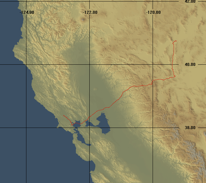
While it is a basic principle of geography that terrain shapes human behavior, it was still a surprise to me to see the image in Figure 5-11 and to again get the lesson! Transportation geography is a fascinating subject. I've spent a bit of time studying the Transport Geography page at http://www.geog.umontreal.ca/Geotrans/.
Mapping Your Life
- Hacks 1-13
- Hack 1. Put a Map on It: Mapping Arbitrary Locations with Online Services
- Hack 2. Route Planning Online
- Hack 3. Map the Places Youve Visited
- Hack 4. Find Your House on an Aerial Photograph
- Hack 5. The Road Less Traveled by in MapQuest
- Hack 6. Make Route Maps Easier to Read
- Hack 7. Will the Kids Barf?
- Hack 8. Publish Maps of Your Photos on the Web
- Hack 9. Track the Friendly Skies with Sherlock
- Hack 10. Georeference Digital Photos
- Hack 11. How Far? How Fast? Geo-Enabling Your Spreadsheet
- Hack 12. Create a Distance Grid in Excel
- Hack 13. Add Maps to Excel Spreadsheets with MapPoint
Mapping Your Neighborhood
- Hacks 14-21
- Hack 14. Make Free Maps of the United States Online
- Hack 15. Zoom Right In on Your Neighborhood
- Hack 16. Who Are the Neighbors Voting For?
- Hack 17. Map Nearby Wi-Fi Hotspots
- Hack 18. Why You Cant Watch Broadcast TV
- Hack 19. Analyze Elevation Profiles for Wireless Community Networks
- Hack 20. Make 3-D Raytraced Terrain Models
- Hack 21. Map Health Code Violations with RDFMapper
Mapping Your World
- Hacks 22-34
- Hack 22. Digging to China
- Hack 23. Explore David Rumseys Historical Maps
- Hack 24. Explore a 3-D Model of the Entire World
- Hack 25. Work with Multiple Lat/Long Formats
- Hack 26. Work with Different Coordinate Systems
- Hack 27. Calculate the Distance Between Points on the Earths Surface
- Hack 28. Experiment with Different Cartographic Projections
- Hack 29. Plot Arbitrary Points on a World Map
- Hack 30. Plot a Great Circle on a Flat Map
- Hack 31. Plot Dymaxion Maps in Perl
- Hack 32. Hack on Base Maps in Your Favorite Image Editor
- Hack 33. Georeference an Arbitrary Tourist Map
- Hack 34. Map Other Planets
Mapping (on) the Web
- Hacks 35-46
- Hack 35. Search Local, Find Global
- Hack 36. Shorten Online Map URLs
- Hack 37. Tweak the Look and Feel of Web Maps
- Hack 38. Add Location to Weblogs and RSS Feeds
- Hack 39. View Your Photo Thumbnails on a Flash Map
- Hack 40. Plot Points on a Spinning Globe Applet
- Hack 41. Plot Points on an Interactive Map Using DHTML
- Hack 42. Map Your Tracklogs on the Web
- Hack 43. Map Earthquakes in (Nearly) Real Time
- Hack 44. Plot Statistics Against Shapes
- Hack 45. Extract a Spatial Model from Wikipedia
- Hack 46. Map Global Weather Conditions
Mapping with Gadgets
- Hacks 47-63
- How GPS Works
- Hack 47. Get Maps on Your Mobile Phone
- Hack 48. Accessorize Your GPS
- Hack 49. Get Your Tracklogs in Windows or Linux
- Hack 50. The Serial Port to USB Conundrum
- Hack 51. Speak in Geotongues: GPSBabel to the Rescue
- Hack 52. Show Your Waypoints on Aerial Photos with Terrabrowser
- Hack 53. Visualize Your Tracks in Three Dimensions
- Hack 54. Create Your Own Maps for a Garmin GPS
- Hack 55. Use Your Track Memory as a GPS Base Map
- Hack 56. Animate Your Tracklogs
- Hack 57. Connect to Your GPS from Multiple Applications
- Hack 58. Dont Lose Your Tracklogs!
- Hack 59. Geocode Your Voice Recordings and Other Media
- Hack 60. Improve the Accuracy of Your GPS with Differential GPS
- Hack 61. Build a Map of Local GSM Cells
- Hack 62. Build a Car Computer
- Hack 63. Build Your Own Car Navigation System with GpsDrive
Mapping on Your Desktop
- Hacks 64-77
- Hack 64. Mapping Local Areas of Interest with Quantum GIS
- Hack 65. Extract Data from Maps with Manifold
- Hack 66. Java-Based Desktop Mapping with Openmap
- Hack 67. Seamless Data Download from the USGS
- Hack 68. Convert Geospatial Data Between Different Formats
- Hack 69. Find Your Way Around GRASS
- Hack 70. Import Your GPS Waypoints and Tracklogs into GRASS
- Hack 71. Turn Your Tracklogs into ESRI Shapefiles
- Hack 72. Add Relief to Your Topographic Maps
- Hack 73. Make Your Own Contour Maps
- Hack 74. Plot Wireless Network Viewsheds with GRASS
- Hack 75. Share Your GRASS Maps with the World
- Hack 76. Explore the Effects of Global Warming
- Conclusion
- Hack 77. Become a GRASS Ninja
Names and Places
- Hacks 78-86
- Hack 78. What to Do if Your Government Is Hoarding Geographic Data
- Hack 79. Geocode a U.S. Street Address
- Hack 80. Automatically Geocode U.S. Addresses
- Hack 81. Clean Up U.S. Addresses
- Hack 82. Find Nearby Things Using U.S. ZIP Codes
- Hack 83. Map Numerical Data the Easy Way
- Hack 84. Build a Free World Gazetteer
- Hack 85. Geocode U.S. Locations with the GNIS
- Hack 86. Track a Package Across the U.S.
Building the Geospatial Web
- Hacks 87-92
- Hack 87. Build a Spatially Indexed Data Store
- Hack 88. Load Your Waypoints into a Spatial Database
- Hack 89. Publish Your Geodata to the Web with GeoServer
- Hack 90. Crawl the Geospatial Web with RedSpider
- Hack 91. Build Interactive Web-Based Map Applications
- Hack 92. Map Wardriving (and other!) Data with MapServer
Mapping with Other People
- Hacks 93-100
- Hack 93. Node Runner
- Hack 94. Geo-Warchalking with 2-D Barcodes
- Hack 95. Model Interactive Spaces
- Hack 96. Share Geo-Photos on the Web
- Hack 97. Set Up an OpenGuide for Your Hometown
- Hack 98. Give Your Great-Great-Grandfather a GPS
- Hack 99. Map Your Friend-of-a-Friend Network
- Hack 100. Map Imaginary Places
EAN: 2147483647
Pages: 172
