Hack 98. Give Your Great-Great-Grandfather a GPS


Learn how to geocode historic documents.
Tracklogs are simply a series of points. We don't need a GPS to create a series of points. In this hack, we'll take an Oregon Trail diary and geocode it to create a series of waypoints. You can thus create tracklogs of events that predate the creation of the GPS system.
Alfred Korzybski wrote, "The map is not the territory." And nowhere is this more clear than when following the traces of your ancestors. Taking a drive along the Oregon Trail, spending a long weekend eating convenience store food and camping in the car, clambering over fences in order to stand exactly where your great-great-grandfather stood or, more likely, simply passed by with a tired sigh, is an experience of assembling an internal reality, an experience of connecting with the past. As must be the case, these connections are one-way. But does that matter? Does it matter that those particular Missouri farmers had less in common with me today (aside from a bit of genetic material) than I have with today's members of the Locative Media Lab spread around the world?
I don't think that it matters. I spent an awestruck evening on top of Independence Rock in Wyoming, feeling the rock as though it were a reliquary, whispering thanks to my great-great-grandfather for having taken the journey that he did and, by so doing, giving me a context for my own existence. Well, maybe I was giving thanks to the myth of a great-great-grandfather that I had constructed. The evening twilight winds of Wyoming have their own power.
I look upon the extract of the Park Service Oregon Trail map in Figure 9-13, and I can read what it says about Register Cliff: "Of the thousands of names carved by emigrants into the soft sandstone, several hundred are still legible. Some trail ruts, as deep as five feet, are three miles west."
Figure 9-13. Part of the Oregon Trail in Nebraska and Wyoming
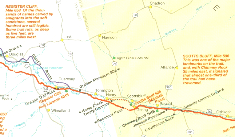
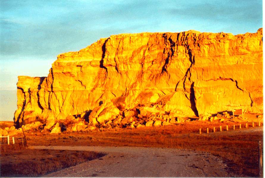
To my great-great-grandfather, Register Cliff might have been an evening's campsite and the lark of carving his family's names in the soft stone. But it is more likely that he rolled on past, driven by the endless whisper of the coming winter snows. And that map is not the territory that I traveled; yet, it is precisely the territory that I traveled. But my territory looked more like Figure 9-14 and included strange creaking sounds at night, a mix of the modern and the historic, the whispering from remote trail graves reachable only by traveling past new oil and gas pipelines, and always the wind and the sunsets.
Figure 9-14. Register Cliff in Wyoming
And all of that brings us to one particular diary of a typical journey on the Oregon Trail. Some of the entries are relatively precise, such as the entry for May 5th, 1852: "Encamped in the Missouri Bottom near Kansville." A web search of the Geographic Names Information System (GNIS) Gazetteer [Hack #85] at http://geonames.usgs.gov/gnishome.html comes up empty. A quick search on Google reveals the alternate spelling "Kanesville." The GNIS lists "Kanesville Center," and "Kanesville Tabernacle and Visitor Center," among other entries. These are all near Council Bluffs, Iowa. So geocoding this location is a simple matter of picking one at random as being "close enough."
Other entries are less clear, such as "Camped three miles east of Chimney Rock." Chimney Rock is a well-known Oregon Trail landmark. But if you didn't know that, searching for "Chimney Rock Oregon Trail" brings up many links and reveals that it is located in Nebraska. A return to the GNIS reveals "Chimney Rock National Historic Site," along with a latitude and longitude.
A good set of maps of the trail will help puzzle out where these sites are. But what is one to do with two weeks worth of entries of the form, "Made 18 miles, camped near the river" and "Made 20 miles and camped near a snow bank"?
One approach is to use maps of the trail and follow along, measuring distances. An alternative is to do the same thing within a GIS program like GRASS or QGIS. Doing a Google search for "Oregon Trail shapefiles" returns some promising links.
Another technique is to interpolate position. In [Hack #11], we learned how to add spatial extensions to Excel. You can download the sample worksheet from that hack from http://www.mappinghacks.com/geospreadsheet/geodata_sample.xls. The sheet myer_diary contains sample work on geocoding the 1853 Oregon Trail diary of Nathanial Myer.
If we simplistically assume that they traveled in a straight line for the points that we have trouble geocoding (I looked for "snow bank" in the GNIS without great success), then we can use the Bearing, newPosLat, and newPosLong functions to calculate a position based on their reported progress each day:
=Bearing(lat1, lon1, lat2, long2)
=newPostLat(la1, lon1, bearing, distance)
=newPostLon(la1, lon1, bearing, distance)
I was initially skeptical of the mileage claims in the diary, so I used the posDist(lat1, lon1, lat2, lon2) function to compare the diary-reported distances with the straight-line distance between my best guess of the positions that I was able to pin down with some confidence. Most of the mileage claims are reasonably close to the straight-line distances. I get numbers like 138 miles, when the straight-line distance is 134 miles. The distances Nathanial reported seem close enough to be usable.
A helpful hint is to see the trail points over aerial photos. If we export our points from Excel into a tab-delimited file, we can read them into Terrabrowser [Hack #52] . Terrabrowser can then save our work in GPX-format files that can be read in a wide variety of other tools.
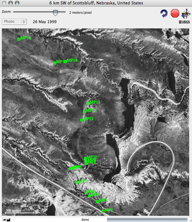
In Figure 9-15, we see a series of waypoints marking a portion of the Oregon Trail through Mitchell Pass. These came from a GPS-enabled ramble over this section of the trail, and so show a much higher level of detail than we can get from our historic documents. But even in this detailed image, we can see areas that are "obviously" part of the trail but are not marked. In Terrabrowser, we can Ctrl-click to bring up a context menu that allows us to mark or copy the location under the click. We can use this to clean up our rough geocoded and interpolated locations.
Figure 9-15. Detail of Mitchell Pass (Scott's Bluff) on the Oregon Trail
The Terrabrowser context menu also includes the "measure distance" tool. Bring up the context menu, select "measure distance," then move to another point, bring up the context menu, and select "measure distance," and the distance will be displayed in the side pane.
The possibilities are as deep as the past when geocoding historic documents. Sailing ship logs? Where you've lived in the past? Historic trails? It doesn't cost anything (except for your free time), so give a GPS to your great-great-grandfather!
9.7.1. See Also
Maps of the Oregon Trail, Gregory M. Franzwa, The Patrice Press
The Oregon Trail Revisited, Gregory M. Franswa, The Patrice Press
The Magic Mountain, Thomas Mann
Mapping Your Life
- Hacks 1-13
- Hack 1. Put a Map on It: Mapping Arbitrary Locations with Online Services
- Hack 2. Route Planning Online
- Hack 3. Map the Places Youve Visited
- Hack 4. Find Your House on an Aerial Photograph
- Hack 5. The Road Less Traveled by in MapQuest
- Hack 6. Make Route Maps Easier to Read
- Hack 7. Will the Kids Barf?
- Hack 8. Publish Maps of Your Photos on the Web
- Hack 9. Track the Friendly Skies with Sherlock
- Hack 10. Georeference Digital Photos
- Hack 11. How Far? How Fast? Geo-Enabling Your Spreadsheet
- Hack 12. Create a Distance Grid in Excel
- Hack 13. Add Maps to Excel Spreadsheets with MapPoint
Mapping Your Neighborhood
- Hacks 14-21
- Hack 14. Make Free Maps of the United States Online
- Hack 15. Zoom Right In on Your Neighborhood
- Hack 16. Who Are the Neighbors Voting For?
- Hack 17. Map Nearby Wi-Fi Hotspots
- Hack 18. Why You Cant Watch Broadcast TV
- Hack 19. Analyze Elevation Profiles for Wireless Community Networks
- Hack 20. Make 3-D Raytraced Terrain Models
- Hack 21. Map Health Code Violations with RDFMapper
Mapping Your World
- Hacks 22-34
- Hack 22. Digging to China
- Hack 23. Explore David Rumseys Historical Maps
- Hack 24. Explore a 3-D Model of the Entire World
- Hack 25. Work with Multiple Lat/Long Formats
- Hack 26. Work with Different Coordinate Systems
- Hack 27. Calculate the Distance Between Points on the Earths Surface
- Hack 28. Experiment with Different Cartographic Projections
- Hack 29. Plot Arbitrary Points on a World Map
- Hack 30. Plot a Great Circle on a Flat Map
- Hack 31. Plot Dymaxion Maps in Perl
- Hack 32. Hack on Base Maps in Your Favorite Image Editor
- Hack 33. Georeference an Arbitrary Tourist Map
- Hack 34. Map Other Planets
Mapping (on) the Web
- Hacks 35-46
- Hack 35. Search Local, Find Global
- Hack 36. Shorten Online Map URLs
- Hack 37. Tweak the Look and Feel of Web Maps
- Hack 38. Add Location to Weblogs and RSS Feeds
- Hack 39. View Your Photo Thumbnails on a Flash Map
- Hack 40. Plot Points on a Spinning Globe Applet
- Hack 41. Plot Points on an Interactive Map Using DHTML
- Hack 42. Map Your Tracklogs on the Web
- Hack 43. Map Earthquakes in (Nearly) Real Time
- Hack 44. Plot Statistics Against Shapes
- Hack 45. Extract a Spatial Model from Wikipedia
- Hack 46. Map Global Weather Conditions
Mapping with Gadgets
- Hacks 47-63
- How GPS Works
- Hack 47. Get Maps on Your Mobile Phone
- Hack 48. Accessorize Your GPS
- Hack 49. Get Your Tracklogs in Windows or Linux
- Hack 50. The Serial Port to USB Conundrum
- Hack 51. Speak in Geotongues: GPSBabel to the Rescue
- Hack 52. Show Your Waypoints on Aerial Photos with Terrabrowser
- Hack 53. Visualize Your Tracks in Three Dimensions
- Hack 54. Create Your Own Maps for a Garmin GPS
- Hack 55. Use Your Track Memory as a GPS Base Map
- Hack 56. Animate Your Tracklogs
- Hack 57. Connect to Your GPS from Multiple Applications
- Hack 58. Dont Lose Your Tracklogs!
- Hack 59. Geocode Your Voice Recordings and Other Media
- Hack 60. Improve the Accuracy of Your GPS with Differential GPS
- Hack 61. Build a Map of Local GSM Cells
- Hack 62. Build a Car Computer
- Hack 63. Build Your Own Car Navigation System with GpsDrive
Mapping on Your Desktop
- Hacks 64-77
- Hack 64. Mapping Local Areas of Interest with Quantum GIS
- Hack 65. Extract Data from Maps with Manifold
- Hack 66. Java-Based Desktop Mapping with Openmap
- Hack 67. Seamless Data Download from the USGS
- Hack 68. Convert Geospatial Data Between Different Formats
- Hack 69. Find Your Way Around GRASS
- Hack 70. Import Your GPS Waypoints and Tracklogs into GRASS
- Hack 71. Turn Your Tracklogs into ESRI Shapefiles
- Hack 72. Add Relief to Your Topographic Maps
- Hack 73. Make Your Own Contour Maps
- Hack 74. Plot Wireless Network Viewsheds with GRASS
- Hack 75. Share Your GRASS Maps with the World
- Hack 76. Explore the Effects of Global Warming
- Conclusion
- Hack 77. Become a GRASS Ninja
Names and Places
- Hacks 78-86
- Hack 78. What to Do if Your Government Is Hoarding Geographic Data
- Hack 79. Geocode a U.S. Street Address
- Hack 80. Automatically Geocode U.S. Addresses
- Hack 81. Clean Up U.S. Addresses
- Hack 82. Find Nearby Things Using U.S. ZIP Codes
- Hack 83. Map Numerical Data the Easy Way
- Hack 84. Build a Free World Gazetteer
- Hack 85. Geocode U.S. Locations with the GNIS
- Hack 86. Track a Package Across the U.S.
Building the Geospatial Web
- Hacks 87-92
- Hack 87. Build a Spatially Indexed Data Store
- Hack 88. Load Your Waypoints into a Spatial Database
- Hack 89. Publish Your Geodata to the Web with GeoServer
- Hack 90. Crawl the Geospatial Web with RedSpider
- Hack 91. Build Interactive Web-Based Map Applications
- Hack 92. Map Wardriving (and other!) Data with MapServer
Mapping with Other People
- Hacks 93-100
- Hack 93. Node Runner
- Hack 94. Geo-Warchalking with 2-D Barcodes
- Hack 95. Model Interactive Spaces
- Hack 96. Share Geo-Photos on the Web
- Hack 97. Set Up an OpenGuide for Your Hometown
- Hack 98. Give Your Great-Great-Grandfather a GPS
- Hack 99. Map Your Friend-of-a-Friend Network
- Hack 100. Map Imaginary Places
EAN: 2147483647
Pages: 172
