Hack 86. Track a Package Across the U.S.


Use free data sources to map your package's progress across the U.S.
Being able to see where a package is on its way to your door was developed as a business process-management tool. But it has turned out to be really popular with customers, too. What if you could take the next step, not only seeing a list of towns your new cell phone is visiting, but seeing them on a map! This hack presents one way of doing this.
7.10.1. Preparation
If you didn't do [Hack #66], take a quick look at it, because Openmap will be used to map our package shipment stops. In essence, you need to install a Version 1.4 or later Java Development Kit and Openmap 4.6. Make sure to copy the file openmap.properties from the program's installation directory into your home directory. After Java and Openmap are set up, you need to make a small modification to the openmap.properties file. Open openmap.properties in a text editor. Search for openmap.layers=. The second occurrence should look something like this:
openmap.layers=date dtlayer distlayer quake daynight cities test graticule demo
shapePolitical
We will be creating a new layer that we want to show up on the map, so add the word "shipment" at the front of the list, which should give you this:
openmap.layers=shipment date dtlayer distlayer quake daynight cities test graticule
demo shapePolitical
7.10.2. Getting Location Information
The first thing we have to do, obviously, is find out where the package has been. There are a variety of ways to do this, depending on the shipping company. Most, such as UPS and FedEx, have APIs for accessing the information you can get from their web site. Unfortunately, these are more difficult to get going with than, for example, the Amazon, eBay, or Google API. Working with them quickly transforms your project from a hack into a full-scale software development effort.
Instead of making use of the programming APIs of the major shippers, we'll use a much older hacking technique: copy and paste. Look up your package's tracking information in the usual way. Then create a text file listing the city and state of each location in chronological order, and save it in a file named places.txt. Your file should look something like this:
Seattle, WA
Austin, Texas
Chicago, Illinois
Boston, Massachusetts
Medford, Massachusetts
Now we're ready to map these locations. To do this, we'll need to translate our list of place names into a list of geographic coordinates, which is a job we already tackled in [Hack #85], which leverages a U.S. Geological Survey database of places for this purpose.
7.10.3. The Code
PackageTracker.java is a Java program that can be run from the command line. It knows how to read the little place-name text file we created and use the GNISCoords class [Hack #85] for geocoding the entries. It can write the new information to disk, or simply to stdout, which can be piped into other applications on Unix-ish operating systems like Mac OS X, Linux, and Solaris. For our purposes, write it to disk so that our mapping program can find it.
The program is too long to print here in full, so we've made it available online at http://mappinghacks.com/code/PackageTracker.java.
7.10.4. Running the Hack
Compile the Java file like this.
$ javac org/rajsingh/maphacks/shipment/PackageTracker.java
If you did the GNIS hack in another place, move the file GNISCoords.class to the same directory as PackageTracker.class and PackageTracker.java.
Now you can run the program. You'll have to provide three items of information on the command line:
- The full path to the file containing the place names, which we called places.txt.
- The full path for the file in which you want the geocoded information saved.
- A value of yes to signal the program to modify Openmap's properties. If you're curious about the Openmap properties file, there's plenty of information about it at http://openmap.bbn.com/cgi-bin/faqw.py?req=show&file=faq06.004.htp.
$ java -cp . org.rajsingh.maphacks.shipment.PackageTracker
   yes
7.10.5. The Results
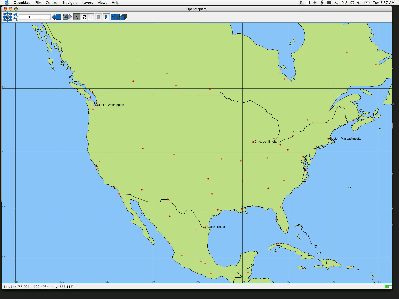
Remember that we started this hack wanting to put our package "on the map"? Well, we're finally there. Since we automatically added our data to Openmap's properties file, all we need to do is run the program. Your final result should look something like Figure 7-7.
Figure 7-7. The resting places of a random package, as it makes its way across the U.S.
See [Hack #66] to learn how to get state boundaries on your map as well.
Raj Singh
Mapping Your Life
- Hacks 1-13
- Hack 1. Put a Map on It: Mapping Arbitrary Locations with Online Services
- Hack 2. Route Planning Online
- Hack 3. Map the Places Youve Visited
- Hack 4. Find Your House on an Aerial Photograph
- Hack 5. The Road Less Traveled by in MapQuest
- Hack 6. Make Route Maps Easier to Read
- Hack 7. Will the Kids Barf?
- Hack 8. Publish Maps of Your Photos on the Web
- Hack 9. Track the Friendly Skies with Sherlock
- Hack 10. Georeference Digital Photos
- Hack 11. How Far? How Fast? Geo-Enabling Your Spreadsheet
- Hack 12. Create a Distance Grid in Excel
- Hack 13. Add Maps to Excel Spreadsheets with MapPoint
Mapping Your Neighborhood
- Hacks 14-21
- Hack 14. Make Free Maps of the United States Online
- Hack 15. Zoom Right In on Your Neighborhood
- Hack 16. Who Are the Neighbors Voting For?
- Hack 17. Map Nearby Wi-Fi Hotspots
- Hack 18. Why You Cant Watch Broadcast TV
- Hack 19. Analyze Elevation Profiles for Wireless Community Networks
- Hack 20. Make 3-D Raytraced Terrain Models
- Hack 21. Map Health Code Violations with RDFMapper
Mapping Your World
- Hacks 22-34
- Hack 22. Digging to China
- Hack 23. Explore David Rumseys Historical Maps
- Hack 24. Explore a 3-D Model of the Entire World
- Hack 25. Work with Multiple Lat/Long Formats
- Hack 26. Work with Different Coordinate Systems
- Hack 27. Calculate the Distance Between Points on the Earths Surface
- Hack 28. Experiment with Different Cartographic Projections
- Hack 29. Plot Arbitrary Points on a World Map
- Hack 30. Plot a Great Circle on a Flat Map
- Hack 31. Plot Dymaxion Maps in Perl
- Hack 32. Hack on Base Maps in Your Favorite Image Editor
- Hack 33. Georeference an Arbitrary Tourist Map
- Hack 34. Map Other Planets
Mapping (on) the Web
- Hacks 35-46
- Hack 35. Search Local, Find Global
- Hack 36. Shorten Online Map URLs
- Hack 37. Tweak the Look and Feel of Web Maps
- Hack 38. Add Location to Weblogs and RSS Feeds
- Hack 39. View Your Photo Thumbnails on a Flash Map
- Hack 40. Plot Points on a Spinning Globe Applet
- Hack 41. Plot Points on an Interactive Map Using DHTML
- Hack 42. Map Your Tracklogs on the Web
- Hack 43. Map Earthquakes in (Nearly) Real Time
- Hack 44. Plot Statistics Against Shapes
- Hack 45. Extract a Spatial Model from Wikipedia
- Hack 46. Map Global Weather Conditions
Mapping with Gadgets
- Hacks 47-63
- How GPS Works
- Hack 47. Get Maps on Your Mobile Phone
- Hack 48. Accessorize Your GPS
- Hack 49. Get Your Tracklogs in Windows or Linux
- Hack 50. The Serial Port to USB Conundrum
- Hack 51. Speak in Geotongues: GPSBabel to the Rescue
- Hack 52. Show Your Waypoints on Aerial Photos with Terrabrowser
- Hack 53. Visualize Your Tracks in Three Dimensions
- Hack 54. Create Your Own Maps for a Garmin GPS
- Hack 55. Use Your Track Memory as a GPS Base Map
- Hack 56. Animate Your Tracklogs
- Hack 57. Connect to Your GPS from Multiple Applications
- Hack 58. Dont Lose Your Tracklogs!
- Hack 59. Geocode Your Voice Recordings and Other Media
- Hack 60. Improve the Accuracy of Your GPS with Differential GPS
- Hack 61. Build a Map of Local GSM Cells
- Hack 62. Build a Car Computer
- Hack 63. Build Your Own Car Navigation System with GpsDrive
Mapping on Your Desktop
- Hacks 64-77
- Hack 64. Mapping Local Areas of Interest with Quantum GIS
- Hack 65. Extract Data from Maps with Manifold
- Hack 66. Java-Based Desktop Mapping with Openmap
- Hack 67. Seamless Data Download from the USGS
- Hack 68. Convert Geospatial Data Between Different Formats
- Hack 69. Find Your Way Around GRASS
- Hack 70. Import Your GPS Waypoints and Tracklogs into GRASS
- Hack 71. Turn Your Tracklogs into ESRI Shapefiles
- Hack 72. Add Relief to Your Topographic Maps
- Hack 73. Make Your Own Contour Maps
- Hack 74. Plot Wireless Network Viewsheds with GRASS
- Hack 75. Share Your GRASS Maps with the World
- Hack 76. Explore the Effects of Global Warming
- Conclusion
- Hack 77. Become a GRASS Ninja
Names and Places
- Hacks 78-86
- Hack 78. What to Do if Your Government Is Hoarding Geographic Data
- Hack 79. Geocode a U.S. Street Address
- Hack 80. Automatically Geocode U.S. Addresses
- Hack 81. Clean Up U.S. Addresses
- Hack 82. Find Nearby Things Using U.S. ZIP Codes
- Hack 83. Map Numerical Data the Easy Way
- Hack 84. Build a Free World Gazetteer
- Hack 85. Geocode U.S. Locations with the GNIS
- Hack 86. Track a Package Across the U.S.
Building the Geospatial Web
- Hacks 87-92
- Hack 87. Build a Spatially Indexed Data Store
- Hack 88. Load Your Waypoints into a Spatial Database
- Hack 89. Publish Your Geodata to the Web with GeoServer
- Hack 90. Crawl the Geospatial Web with RedSpider
- Hack 91. Build Interactive Web-Based Map Applications
- Hack 92. Map Wardriving (and other!) Data with MapServer
Mapping with Other People
- Hacks 93-100
- Hack 93. Node Runner
- Hack 94. Geo-Warchalking with 2-D Barcodes
- Hack 95. Model Interactive Spaces
- Hack 96. Share Geo-Photos on the Web
- Hack 97. Set Up an OpenGuide for Your Hometown
- Hack 98. Give Your Great-Great-Grandfather a GPS
- Hack 99. Map Your Friend-of-a-Friend Network
- Hack 100. Map Imaginary Places
EAN: 2147483647
Pages: 172
