Hack 14. Make Free Maps of the United States Online


The U.S. Census Bureau's TIGER Map Server isn't fast or fancy, but the maps it makes are free and entirely hackable.
Although the maps made by MapQuest, map24.com, and other commercial mapping services are nice looking, fast, and reasonably effective, their use is severely limited by their licensing terms. What's more, you can't easily map your own data on top of the digital maps these services produce. However, in the United States, we enjoy a remarkable plethora of public-domain geographic data, much of it in the form of the Census Bureau's TIGER/Line data set, which the Bureau uses as the basis for the TIGER Map Server, a free web-based mapping service, covering the entire United States. You can browse their maps manually, or programmatically generate unencumbered, public-domain maps through their service for your own purposes. We'll look at both of these uses of the TIGER Map Server.
|

2.2.1. Browsing the Web Interface
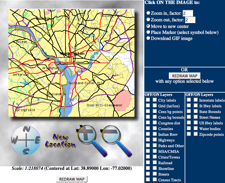
The TIGER Map Server Browser lives at http://tiger.census.gov/cgi-bin/mapsurfer. With no other options supplied to it, the Browser loads a map of Washington, DC, by default. Included are the usual web-based map interface buttons for panning and zooming, and, on the upper right, a set of radio buttons selects the action that's taken when the map is clicked on. While the zoom in, zoom out, and recenter commands are pretty standard for an online map service, that's where the similarity to other such services ends. The next two commands allow you to put a marker of your choice anywhere on the map with a click and then download a GIF image of the map you've created. Further down the right side, you can select precisely which features you want displayed on the map. Let's see you do that, MapQuest! Figure 2-1 shows the basic web interface to the TIGER Map Server.
Figure 2-1. The basic web interface to the TIGER Map Server
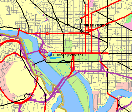
That's just for starters, though. If you scroll down the page, you'll see form elements that allow you to request a map centered at a particular latitude and longitude, or one based on a search for a particular location or ZIP code. Additionally, there's an interface that allows you to select a particular graphical marker from a lista ball, pin, or other iconand place it on the map, either by selecting the appropriate radio button at the top and then clicking on the map, or by entering latitude and longitude coordinates. There's also a form field that allows you to add a label to the marker. Figure 2-2 shows a TIGER Map Server map of downtown Washington, DC, with a blue pin identifying the Lincoln Memorial.
Figure 2-2. The Lincoln Memorial, as shown by the TIGER Map Server
Now, this may not be the finest map you've ever seen, from the standpoint of cartographic design, but it already scores over many other mapping services in two important respects. First, you can do whatever the heck you want with itthese maps are in the public domain. Second, you can plot your own stuff on it. These maps can help tell your story.
2.2.2. Mapping a List of Points
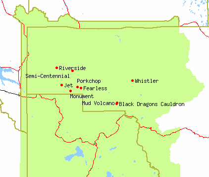
It gets even better. What if you want to display more than one marker on the map at a time? See the text field labeled Marker URL? It turns out that if you make a list of waypoints, you can put it on the Web somewhere and use the Marker URL field to tell the TIGER server to fetch it and map it. Here are the first six entries in a list of geysers in Yellowstone National Park, taken from the GNIS [Hack #85] and rendered in the TIGER Map Server's ad hoc Marker URL "format":
# Excerpted list of GNIS geyser features from Park County, WY
-110.4347,44.6203:red5:Black Dragons Cauldron
-110.6833,44.7000:red5:Fearless
-110.8167,44.7167:red5:Jet
-110.7528,44.6833:red5:Monument
-110.4333,44.6247:red5:Mud Volcano
-110.7067,44.7056:red5:Porkchop
The first line is a comment, as indicated by the hash mark (#) at the beginning of the line. For the remainder of the file, each line is a waypoint, with three colon-separated fields. The first field is longitude, latitude, separated by a comma. The next field is the marker type, which we'll get into more detail about in a minute. Finally, the last field is just the name of the waypoint. This particular file contains a total of nine entries. If we post the file at http://mappinghacks.com/data/geysers.txt, we can put that URL into the TIGER Map Server web form, set the latitude and longitude to something appropriate, and hit "Redraw Map." The result looks something like Figure 2-3.
Figure 2-3. Some Yellowstone geysers, mapped via Marker URL
|

2.2.3. Hacking the Hack
The best part about the TIGER mapping service is that you don't have to use their web interface to make maps; you can automatically generate them by crafting a custom TIGER Map Server URL that specifies the details for the map you want. The map image, which is rendered in a simple sinusoidal projection, is then returned in GIF format. The request URL takes the following basic form:
http://tiger.census.gov/cgi-bin/mapgen?param=value¶m=value&...
The types of parameters available for direct request are in essence the same as those used in the web interface. For example, this URL will generate a nice, simple map of Lower Manhattan in New York City, which is shown in Figure 2-4:
http://tiger.census.gov/cgi-bin/mapgen?lat=40.739&lon=
-73.99&wid=0.06&ht=0.08&iwd=480&iht=640
Figure 2-4. A map of Lower Manhattan generated by direct request
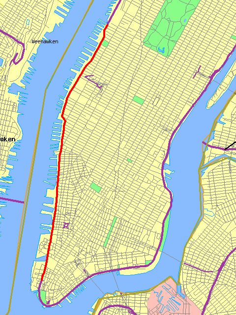
The lat and lon parameters specify latitude and longitude, respectively, in decimal degrees. The wid and ht parameters specify the width and height of the maps in decimal degrees, while iwd and iht parameters specify the width and height of the desired map in pixels. So the map in Figure 2-4 should come out 480 pixels wide by 640 pixels high. If the aspect ratio specified by iwd and iht is different from that specified by wid and htand remember that, in the continental U.S., a degree of latitude is about 1.5 times longer than a degree of longitudethen the map coverage may come out a little differently than requested, but that shouldn't ordinarily present a problem.
The TIGER Map Service supports a whole lot of other tweakable parameters. Table 2-1 lists some of them. See the TIGER Map Service instructions page at http://tiger.census.gov/instruct.html for exact details.
|
Parameter |
Description |
Notes |
|---|---|---|
|
lat |
Latitude of the map center in decimal degrees |
Values for the continental U.S. range from around -125 to -67. |
|
lon |
Longitude of map center in decimal degrees |
Values for the continental U.S. range from around 24 to 49 |
|
wid |
Width of map coverage in decimal degrees |
1º of longitude = ~55 mi at 24º N, ~40 mi at 49º N |
|
ht |
Height of map coverage in decimal degrees |
1º of latitude = ~60 mi or 100 km |
|
iwd |
Width of map image in pixels |
Defaults to 512 pixels |
|
iht |
Height of map image in pixels |
Defaults to 256 pixels |
|
legend |
Show map legend instead |
If set to on, the map legend is returned in place of the map. |
|
mark |
Map marker locations, in format lon,lat,marker;lon,lat,marker;... |
See http://tiger.census.gov/instruct.html for a complete list of marker types |
|
murl |
URL to a list of map markers to display |
See Section 2.2.2 for details about the marker file format |
|
on |
Explicitly include certain map features |
See http://tiger.census.gov/instruct.html for a complete list of map features |
|
off |
Explicitly exclude certain map features |
See http://tiger.census.gov/instruct.html for a complete list of map features |
2.2.4. Mapping Census Data
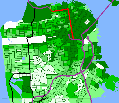
But, wait, there's more! The TIGER Map Service also offers a means for generating simple maps of the Census Bureau's demographic data, in the form of thematic statistical maps. From the web interface, you can select a demographic variable, such as median income or population density, and a level of granularity to display that variable at, from statewide all the way down to a few city blocks. For example, Figure 2-5 shows the percentage of renter-occupied housing units in San Francisco at the Census block group level.
Figure 2-5. A thematic map of renter-occupied housing units in San Francisco
These maps were the precursor to the American FactFinder, which is a web site hosted by the Census Bureau at http://factfinder.census.gov/. The American FactFinder offers an unbelievable wealth of demographic information about the United States, as well as a whole suite of interactive maps based on the TIGER/Line data. We absolutely recommend devoting some spare time to exploring their site, especially if you have a particular interest in mapping demographics. However, we elected to devote an entire hack to the older TIGER Map Service because, for our purposes, the maps it produces are a lot easier to hack than those of its somewhat flashier successor.
2.2.5. The Pros and Cons of the TIGER Map Service
Before you get excited and start building mission-critical applications based on the TIGER Map Server, there are a few things to consider about these maps. First, they are made from map data dating back to 1997, so the maps may be somewhat outdated. Second, the TIGER Map Server is sometimes inexplicably slow or doesn't respond at all. Third, the service comes with no warranty at all. To quote from their instructions page:
The Census Bureau has continued to maintain the TIGER Mapping Service because it has proved useful to the general public. It was never intended to be a robust all-purpose mapping system to meet the needs of high-volume government, business or other organizations' applications... Any application that uses our mapping service does so at the user's risk. The Census Bureau plans continue to try to maintain the TIGER Mapping Service for at least the near future at its current level, but we accept no obligation to provide special support (or timely repair) of the system so that it can meet some other governmental, commercial or organizational mission.
On the other hand, as we've seen, these maps are pretty hackableand they're free!
Mapping Your Life
- Hacks 1-13
- Hack 1. Put a Map on It: Mapping Arbitrary Locations with Online Services
- Hack 2. Route Planning Online
- Hack 3. Map the Places Youve Visited
- Hack 4. Find Your House on an Aerial Photograph
- Hack 5. The Road Less Traveled by in MapQuest
- Hack 6. Make Route Maps Easier to Read
- Hack 7. Will the Kids Barf?
- Hack 8. Publish Maps of Your Photos on the Web
- Hack 9. Track the Friendly Skies with Sherlock
- Hack 10. Georeference Digital Photos
- Hack 11. How Far? How Fast? Geo-Enabling Your Spreadsheet
- Hack 12. Create a Distance Grid in Excel
- Hack 13. Add Maps to Excel Spreadsheets with MapPoint
Mapping Your Neighborhood
- Hacks 14-21
- Hack 14. Make Free Maps of the United States Online
- Hack 15. Zoom Right In on Your Neighborhood
- Hack 16. Who Are the Neighbors Voting For?
- Hack 17. Map Nearby Wi-Fi Hotspots
- Hack 18. Why You Cant Watch Broadcast TV
- Hack 19. Analyze Elevation Profiles for Wireless Community Networks
- Hack 20. Make 3-D Raytraced Terrain Models
- Hack 21. Map Health Code Violations with RDFMapper
Mapping Your World
- Hacks 22-34
- Hack 22. Digging to China
- Hack 23. Explore David Rumseys Historical Maps
- Hack 24. Explore a 3-D Model of the Entire World
- Hack 25. Work with Multiple Lat/Long Formats
- Hack 26. Work with Different Coordinate Systems
- Hack 27. Calculate the Distance Between Points on the Earths Surface
- Hack 28. Experiment with Different Cartographic Projections
- Hack 29. Plot Arbitrary Points on a World Map
- Hack 30. Plot a Great Circle on a Flat Map
- Hack 31. Plot Dymaxion Maps in Perl
- Hack 32. Hack on Base Maps in Your Favorite Image Editor
- Hack 33. Georeference an Arbitrary Tourist Map
- Hack 34. Map Other Planets
Mapping (on) the Web
- Hacks 35-46
- Hack 35. Search Local, Find Global
- Hack 36. Shorten Online Map URLs
- Hack 37. Tweak the Look and Feel of Web Maps
- Hack 38. Add Location to Weblogs and RSS Feeds
- Hack 39. View Your Photo Thumbnails on a Flash Map
- Hack 40. Plot Points on a Spinning Globe Applet
- Hack 41. Plot Points on an Interactive Map Using DHTML
- Hack 42. Map Your Tracklogs on the Web
- Hack 43. Map Earthquakes in (Nearly) Real Time
- Hack 44. Plot Statistics Against Shapes
- Hack 45. Extract a Spatial Model from Wikipedia
- Hack 46. Map Global Weather Conditions
Mapping with Gadgets
- Hacks 47-63
- How GPS Works
- Hack 47. Get Maps on Your Mobile Phone
- Hack 48. Accessorize Your GPS
- Hack 49. Get Your Tracklogs in Windows or Linux
- Hack 50. The Serial Port to USB Conundrum
- Hack 51. Speak in Geotongues: GPSBabel to the Rescue
- Hack 52. Show Your Waypoints on Aerial Photos with Terrabrowser
- Hack 53. Visualize Your Tracks in Three Dimensions
- Hack 54. Create Your Own Maps for a Garmin GPS
- Hack 55. Use Your Track Memory as a GPS Base Map
- Hack 56. Animate Your Tracklogs
- Hack 57. Connect to Your GPS from Multiple Applications
- Hack 58. Dont Lose Your Tracklogs!
- Hack 59. Geocode Your Voice Recordings and Other Media
- Hack 60. Improve the Accuracy of Your GPS with Differential GPS
- Hack 61. Build a Map of Local GSM Cells
- Hack 62. Build a Car Computer
- Hack 63. Build Your Own Car Navigation System with GpsDrive
Mapping on Your Desktop
- Hacks 64-77
- Hack 64. Mapping Local Areas of Interest with Quantum GIS
- Hack 65. Extract Data from Maps with Manifold
- Hack 66. Java-Based Desktop Mapping with Openmap
- Hack 67. Seamless Data Download from the USGS
- Hack 68. Convert Geospatial Data Between Different Formats
- Hack 69. Find Your Way Around GRASS
- Hack 70. Import Your GPS Waypoints and Tracklogs into GRASS
- Hack 71. Turn Your Tracklogs into ESRI Shapefiles
- Hack 72. Add Relief to Your Topographic Maps
- Hack 73. Make Your Own Contour Maps
- Hack 74. Plot Wireless Network Viewsheds with GRASS
- Hack 75. Share Your GRASS Maps with the World
- Hack 76. Explore the Effects of Global Warming
- Conclusion
- Hack 77. Become a GRASS Ninja
Names and Places
- Hacks 78-86
- Hack 78. What to Do if Your Government Is Hoarding Geographic Data
- Hack 79. Geocode a U.S. Street Address
- Hack 80. Automatically Geocode U.S. Addresses
- Hack 81. Clean Up U.S. Addresses
- Hack 82. Find Nearby Things Using U.S. ZIP Codes
- Hack 83. Map Numerical Data the Easy Way
- Hack 84. Build a Free World Gazetteer
- Hack 85. Geocode U.S. Locations with the GNIS
- Hack 86. Track a Package Across the U.S.
Building the Geospatial Web
- Hacks 87-92
- Hack 87. Build a Spatially Indexed Data Store
- Hack 88. Load Your Waypoints into a Spatial Database
- Hack 89. Publish Your Geodata to the Web with GeoServer
- Hack 90. Crawl the Geospatial Web with RedSpider
- Hack 91. Build Interactive Web-Based Map Applications
- Hack 92. Map Wardriving (and other!) Data with MapServer
Mapping with Other People
- Hacks 93-100
- Hack 93. Node Runner
- Hack 94. Geo-Warchalking with 2-D Barcodes
- Hack 95. Model Interactive Spaces
- Hack 96. Share Geo-Photos on the Web
- Hack 97. Set Up an OpenGuide for Your Hometown
- Hack 98. Give Your Great-Great-Grandfather a GPS
- Hack 99. Map Your Friend-of-a-Friend Network
- Hack 100. Map Imaginary Places
EAN: 2147483647
Pages: 172
