Hack 63. Build Your Own Car Navigation System with GpsDrive


Watch your position on a map move as you move. What a novel concept!
Thomas Hargrove is right in [Hack #62] that having an in-car (or on-bike) navigation system makes you the envy of all your (geek) friends. GpsDrive is an open source Linux, FreeBSD, and Mac OS X program that connects to a GPS and displays your current position and your track on a map. GpsDrive also has an interface to aid you in downloading maps from Expedia, or you can make your own maps.
One night I tested the program's map-download function on a drive down to a hosting center in Fremont. I needed to add another hard drive to the server that hosts http://geocoder.us and http://mappinghacks.com. As I headed south, I left the area of the GpsDrive map that I had prepared in advance. If you drive off of the current map, GpsDrive stops showing your current position. So when I pulled up at a stoplight in San Francisco, I connected to a random open wireless network and downloaded a map. I repeated this pattern through most of the city: stop at a light, try to connect, download one or two maps, and then pull away.
There is something strangely compelling about seeing your track as it picks its way across a map that you just downloaded while stopped at a light.
5.19.1. Installing and Using GpsDrive
GpsDrive is available at: http://www.gpsdrive.de. Under Linux, download the appropriate RPM and then type:
$ rpm -ivh gpsdrive-2.09.i386.rpm.
Of course, you can also compile from source code. Under FreeBSD, use the ports collection:
$ cd /usr/ports/astro/gpsdrive
$ sudo make install; make clean
$ rehash
And then start GpsDrive:
$ gpsdrive
GpsDrive supports various GPS options. I connected a Garmin III plus to the serial port on a machine running Fedora Core 2. In GpsDrive, click on Preferences images/ent/U2192.GIF border=0> Settings 2. I set my GPS to communicate in NMEA mode, and so I selected "Use serial conn" to directly talk to the serial port. I set the serial port to /dev/ttyS1, and then used chmod to set the permissions on /dev/ttyS1. NMEA talks at 4800 by default, so leave that alone.
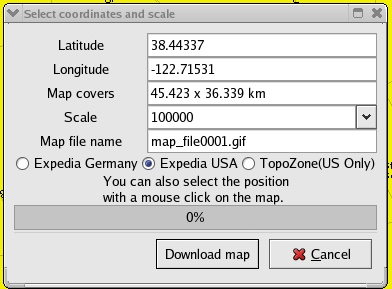
Clicking "Download map" brings up the dialog shown in Figure 5-44. You can select the source of your map and the scale. The filename is automatically incremented, so you can download as many maps as you want. The maps are stored as GIF images in the directory specified under Preferences images/ent/U2192.GIF border=0> Settings 2
images/ent/U2192.GIF border=0> Maps directory. GpsDrive uses the file map_koord.txt (can you tell it was written by Germans?) as a simple georeferencing system.
Figure 5-44. GpsDrive map download window
A sample map_koord.txt file:
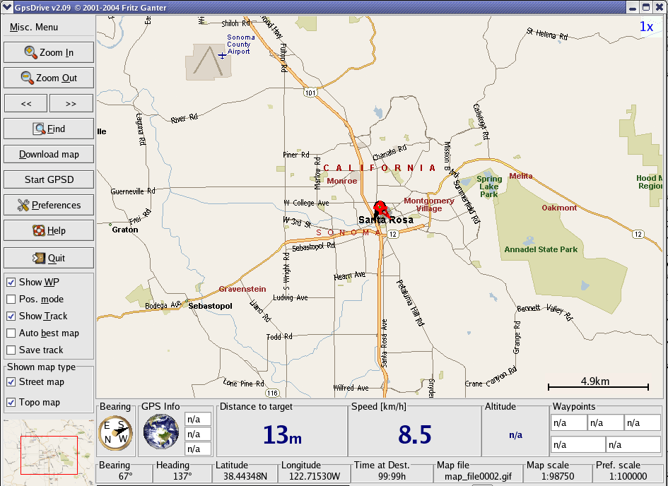
map_file0000.gif 38.44337 -122.71536 3950
map_file0001.gif 38.44346 -122.71544 98750
In this example, map_file0001.gif is centered at 38.44346, -122.71544 and will be shown when you zoom out at a scale of about 1:100,000 (Figure 5-45).
Figure 5-45. Downloaded map in GpsDrive
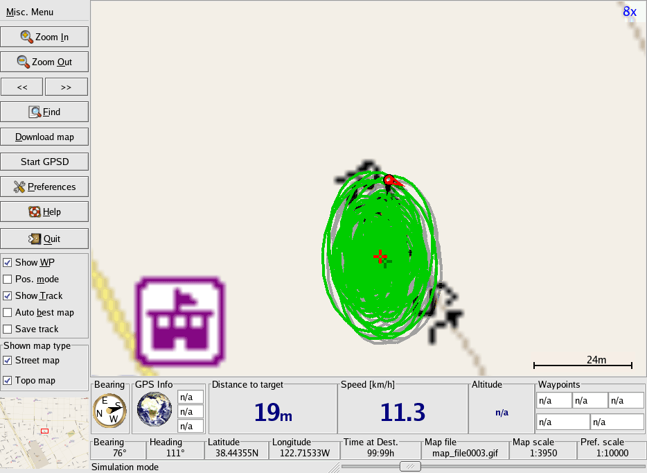
When you zoom in too far, you can see the effects of wandering GPS accuracy. In Figure 5-46, you can see a "track" I gathered while standing still.
Figure 5-46. Zooming in while sitting still shows the effects of GPS "drift"
5.19.2. Adding Your Own Maps
Since GpsDrive maps are regular images, you can create your own maps. A GpsDrive map is a 1280 1024 pixel GIF image. You can use the Misc Menu images/ent/U2192.GIF border=0> Maps
images/ent/U2192.GIF border=0> Import map tool to import a map, or you can directly edit the map_koord.txt file.
Any image named map_filennnn (where nnnn is replaced with a number) can be used as a GpsDrive map. You can also edit the maps that GpsDrive downloads from Expedia. Maps are stored in your home directory in ./gpsdrive.
Each line contains a filename, the latitude at the center of the map, and a scale. So you can customize a map by taking an existing map and adding your own annotations. If you select "Auto Best Map" from the checkboxes on the left side of the screen, GpsDrive will automatically pick the best scale for the map. You can then set the largest-scale maps to be regular photographs. It's fun to pull up at your destination and have your navigation system show you a picture.
5.19.3. Playing Nice with Others
Since GpsDrive can use gpsd [Hack #57] , you can run other GPS-aware applications in conjunction with your navigation system. For example, you can run Kismet to do network wardriving [Hack #17], and the gpslogger.pl script [Hack #58] to allow you to do real time geo-annotaion.
If you like the program as much as I do, then send Friedrich Ganter a few dollars to help with his hosting fees. The PayPal donation link is on the GpsDrive site.
Now have fun with GpsDrive, but (and you can hear this one coming, right?) please be careful while driving (and yes, I mean you, with the laptop balanced on the console, cup of coffee in one hand, cell phone in the other, fumbling with your GPS, trying to get a signal lock!).
Mapping Your Life
- Hacks 1-13
- Hack 1. Put a Map on It: Mapping Arbitrary Locations with Online Services
- Hack 2. Route Planning Online
- Hack 3. Map the Places Youve Visited
- Hack 4. Find Your House on an Aerial Photograph
- Hack 5. The Road Less Traveled by in MapQuest
- Hack 6. Make Route Maps Easier to Read
- Hack 7. Will the Kids Barf?
- Hack 8. Publish Maps of Your Photos on the Web
- Hack 9. Track the Friendly Skies with Sherlock
- Hack 10. Georeference Digital Photos
- Hack 11. How Far? How Fast? Geo-Enabling Your Spreadsheet
- Hack 12. Create a Distance Grid in Excel
- Hack 13. Add Maps to Excel Spreadsheets with MapPoint
Mapping Your Neighborhood
- Hacks 14-21
- Hack 14. Make Free Maps of the United States Online
- Hack 15. Zoom Right In on Your Neighborhood
- Hack 16. Who Are the Neighbors Voting For?
- Hack 17. Map Nearby Wi-Fi Hotspots
- Hack 18. Why You Cant Watch Broadcast TV
- Hack 19. Analyze Elevation Profiles for Wireless Community Networks
- Hack 20. Make 3-D Raytraced Terrain Models
- Hack 21. Map Health Code Violations with RDFMapper
Mapping Your World
- Hacks 22-34
- Hack 22. Digging to China
- Hack 23. Explore David Rumseys Historical Maps
- Hack 24. Explore a 3-D Model of the Entire World
- Hack 25. Work with Multiple Lat/Long Formats
- Hack 26. Work with Different Coordinate Systems
- Hack 27. Calculate the Distance Between Points on the Earths Surface
- Hack 28. Experiment with Different Cartographic Projections
- Hack 29. Plot Arbitrary Points on a World Map
- Hack 30. Plot a Great Circle on a Flat Map
- Hack 31. Plot Dymaxion Maps in Perl
- Hack 32. Hack on Base Maps in Your Favorite Image Editor
- Hack 33. Georeference an Arbitrary Tourist Map
- Hack 34. Map Other Planets
Mapping (on) the Web
- Hacks 35-46
- Hack 35. Search Local, Find Global
- Hack 36. Shorten Online Map URLs
- Hack 37. Tweak the Look and Feel of Web Maps
- Hack 38. Add Location to Weblogs and RSS Feeds
- Hack 39. View Your Photo Thumbnails on a Flash Map
- Hack 40. Plot Points on a Spinning Globe Applet
- Hack 41. Plot Points on an Interactive Map Using DHTML
- Hack 42. Map Your Tracklogs on the Web
- Hack 43. Map Earthquakes in (Nearly) Real Time
- Hack 44. Plot Statistics Against Shapes
- Hack 45. Extract a Spatial Model from Wikipedia
- Hack 46. Map Global Weather Conditions
Mapping with Gadgets
- Hacks 47-63
- How GPS Works
- Hack 47. Get Maps on Your Mobile Phone
- Hack 48. Accessorize Your GPS
- Hack 49. Get Your Tracklogs in Windows or Linux
- Hack 50. The Serial Port to USB Conundrum
- Hack 51. Speak in Geotongues: GPSBabel to the Rescue
- Hack 52. Show Your Waypoints on Aerial Photos with Terrabrowser
- Hack 53. Visualize Your Tracks in Three Dimensions
- Hack 54. Create Your Own Maps for a Garmin GPS
- Hack 55. Use Your Track Memory as a GPS Base Map
- Hack 56. Animate Your Tracklogs
- Hack 57. Connect to Your GPS from Multiple Applications
- Hack 58. Dont Lose Your Tracklogs!
- Hack 59. Geocode Your Voice Recordings and Other Media
- Hack 60. Improve the Accuracy of Your GPS with Differential GPS
- Hack 61. Build a Map of Local GSM Cells
- Hack 62. Build a Car Computer
- Hack 63. Build Your Own Car Navigation System with GpsDrive
Mapping on Your Desktop
- Hacks 64-77
- Hack 64. Mapping Local Areas of Interest with Quantum GIS
- Hack 65. Extract Data from Maps with Manifold
- Hack 66. Java-Based Desktop Mapping with Openmap
- Hack 67. Seamless Data Download from the USGS
- Hack 68. Convert Geospatial Data Between Different Formats
- Hack 69. Find Your Way Around GRASS
- Hack 70. Import Your GPS Waypoints and Tracklogs into GRASS
- Hack 71. Turn Your Tracklogs into ESRI Shapefiles
- Hack 72. Add Relief to Your Topographic Maps
- Hack 73. Make Your Own Contour Maps
- Hack 74. Plot Wireless Network Viewsheds with GRASS
- Hack 75. Share Your GRASS Maps with the World
- Hack 76. Explore the Effects of Global Warming
- Conclusion
- Hack 77. Become a GRASS Ninja
Names and Places
- Hacks 78-86
- Hack 78. What to Do if Your Government Is Hoarding Geographic Data
- Hack 79. Geocode a U.S. Street Address
- Hack 80. Automatically Geocode U.S. Addresses
- Hack 81. Clean Up U.S. Addresses
- Hack 82. Find Nearby Things Using U.S. ZIP Codes
- Hack 83. Map Numerical Data the Easy Way
- Hack 84. Build a Free World Gazetteer
- Hack 85. Geocode U.S. Locations with the GNIS
- Hack 86. Track a Package Across the U.S.
Building the Geospatial Web
- Hacks 87-92
- Hack 87. Build a Spatially Indexed Data Store
- Hack 88. Load Your Waypoints into a Spatial Database
- Hack 89. Publish Your Geodata to the Web with GeoServer
- Hack 90. Crawl the Geospatial Web with RedSpider
- Hack 91. Build Interactive Web-Based Map Applications
- Hack 92. Map Wardriving (and other!) Data with MapServer
Mapping with Other People
- Hacks 93-100
- Hack 93. Node Runner
- Hack 94. Geo-Warchalking with 2-D Barcodes
- Hack 95. Model Interactive Spaces
- Hack 96. Share Geo-Photos on the Web
- Hack 97. Set Up an OpenGuide for Your Hometown
- Hack 98. Give Your Great-Great-Grandfather a GPS
- Hack 99. Map Your Friend-of-a-Friend Network
- Hack 100. Map Imaginary Places
EAN: 2147483647
Pages: 172
