Hack 17. Map Nearby Wi-Fi Hotspots


Create interesting and useful maps of local and international Wi-Fi hotspot coverage.
Ever wonder how you can track the wireless networks in your neighborhood, or near your officeor how you can find free wireless connectivity when you're away from your home and office? I wondered the same thing, and so with the help of Eric Blevins, we created http://www.WiFiMaps.com for exactly this purpose.
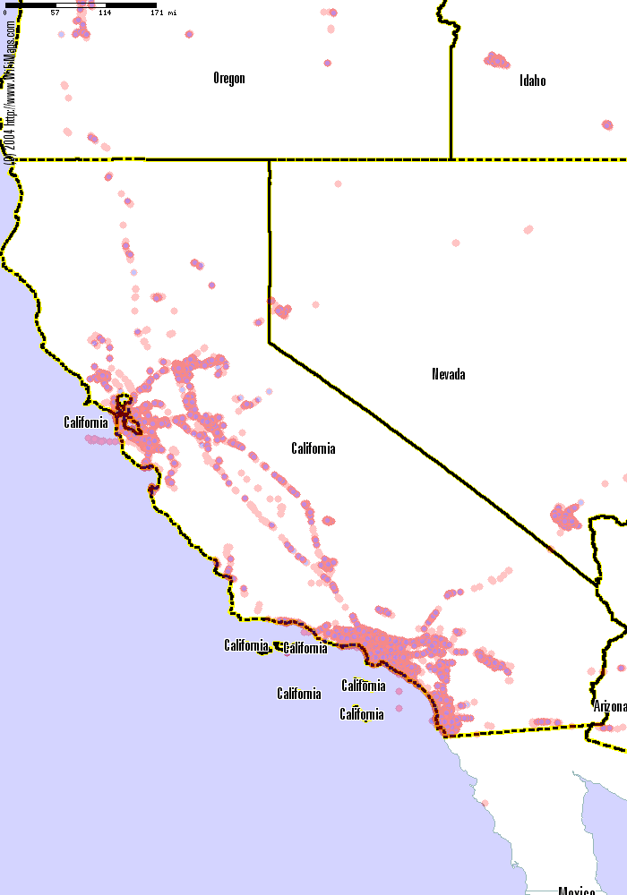
WiFiMaps.com is a web-based, interactive map of wireless networks, with detailed street-level maps. If you're looking for open Wi-Fi nodes nearby, you can use the web site to browse geographical areas, perform various types of searches, and compare location or user statistics. The wireless node data is kept up to date by users who upload their wardriving data. Figure 2-11 shows a map of some of the Wi-Fi hotspots found in California, made with data contributed to WiFiMaps.com.
Figure 2-11. Wi-Fi hotspots in California
2.5.1. The Art of Wardriving
Wardriving is the geek sport of driving about (or walking, or biking, or even flying) while searching for wireless networks. The idea is to connect a GPS and wireless card to your portable computer, hop in the car, fire up your favorite wardriving program, and go out for a drive. As you move, the GPS records your location and some of the parameters of what your wireless card hears. The software on your portable computer takes note of the GPS coordinates and signal strength, and it usually beeps when a new network is found.
|

Mapping wireless networks can reveal patterns that are not always obvious. In the Wi-Fi map of California (Figure 2-11), we see the expected concentration of networks mirroring the populated parts of the state, but we also see the string of networks down the main highways.
Wardriving works because wireless networks broadcast beacon packets to identify themselves. Listening for these beacons does not require connecting to a network, and is (probably) legal. A number of people and businesses intentionally leave their networks open for use, and it is legal to connect to these networks. For instance, down the street from me is a network called "Beehive," which corresponds to the coffee shop of the same name that has a giant sign reading "Free Wireless Internet." A network named "Go Away" is most likely private. In between these extremes lies a vast gray area, where determining which networks are intended to be open is a policy question beyond the scope of this hack.
2.5.2. Collecting Data with NetStumbler
The most popular wardriving package for Windows is called NetStumbler, and it's available from http://www.netstumbler.com/. This package supports several different wireless cards, GPS logging, and a few extra features, and it's what I use when wardriving. On Linux and BSD, you can use Kismet, available from http://www.kismetwireless.net/, which has features similar to NetStumbler'sbut you will also need to run gpsd [Hack #57] . On the Mac, try MacStumbler (http://www.macstumbler.com/) or KisMAC (http://binaervarianz.de/projekte/programmieren/kismac/).
|

WiFiMaps.com parses most of the native wardriving log formats. NetStumbler will export to WiScan format, a text-based format, or its own binary .ns1 format. Regardless of which format you save your scans in, you'll want to upload them to WiFiMaps.com.
2.5.3. Uploading Your NetStumbler Logs
After your wardrive, take your resulting files and upload them to http://WiFiMaps.com/ by selecting the "upload" link at the top of the main page. You can create an account or upload anonymously. The upload parsing script will run once every night and publish the results in the morning. From there, you can determine the number of networks and individual points you have found, and you can browse the maps to see your results.
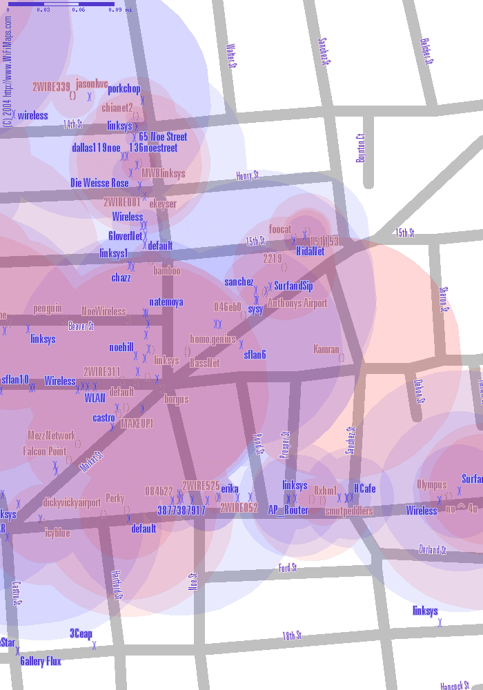
You can see from the image shown in Figure 2-12 that warchalking symbols are used to indicate the existence of security; the )( symbol shows an open network, while the ( ) stands for a closed network. The colors are also used to indicate security: red for closed, blue for open. Experiment with zooming in and out, and panning through your area.
Figure 2-12. Wi-Fi hotspots in San Francisco
|
2.5.4. Warning, Traffic Ahead!
If you don't have lots of spare time, simply wardriving your commute can show you the networks on your route. You can vary your route sometimes, in order to cover a wider distance. Even covering the same area repeatedly is useful for picking up signals that are missed the first time or are very faint.
Wardriving can become a bit of an obsession. To maximize your coverage, print out the Wi-Fi maps of your areas and take them with you. Mark the roads you travel on, and drive through populated intersections a couple of timesthis will improve the quality of your collected data. A good source for other wardriving tips and tricks can be found at http://wardrive.net/.
Please pay attention to the road, to pedestrians, and to other types of hazards! Wardriving can be loads of fun, but make sure you enjoy it in a safe and productive way.
Drew from Zhrodague
Mapping Your Life
- Hacks 1-13
- Hack 1. Put a Map on It: Mapping Arbitrary Locations with Online Services
- Hack 2. Route Planning Online
- Hack 3. Map the Places Youve Visited
- Hack 4. Find Your House on an Aerial Photograph
- Hack 5. The Road Less Traveled by in MapQuest
- Hack 6. Make Route Maps Easier to Read
- Hack 7. Will the Kids Barf?
- Hack 8. Publish Maps of Your Photos on the Web
- Hack 9. Track the Friendly Skies with Sherlock
- Hack 10. Georeference Digital Photos
- Hack 11. How Far? How Fast? Geo-Enabling Your Spreadsheet
- Hack 12. Create a Distance Grid in Excel
- Hack 13. Add Maps to Excel Spreadsheets with MapPoint
Mapping Your Neighborhood
- Hacks 14-21
- Hack 14. Make Free Maps of the United States Online
- Hack 15. Zoom Right In on Your Neighborhood
- Hack 16. Who Are the Neighbors Voting For?
- Hack 17. Map Nearby Wi-Fi Hotspots
- Hack 18. Why You Cant Watch Broadcast TV
- Hack 19. Analyze Elevation Profiles for Wireless Community Networks
- Hack 20. Make 3-D Raytraced Terrain Models
- Hack 21. Map Health Code Violations with RDFMapper
Mapping Your World
- Hacks 22-34
- Hack 22. Digging to China
- Hack 23. Explore David Rumseys Historical Maps
- Hack 24. Explore a 3-D Model of the Entire World
- Hack 25. Work with Multiple Lat/Long Formats
- Hack 26. Work with Different Coordinate Systems
- Hack 27. Calculate the Distance Between Points on the Earths Surface
- Hack 28. Experiment with Different Cartographic Projections
- Hack 29. Plot Arbitrary Points on a World Map
- Hack 30. Plot a Great Circle on a Flat Map
- Hack 31. Plot Dymaxion Maps in Perl
- Hack 32. Hack on Base Maps in Your Favorite Image Editor
- Hack 33. Georeference an Arbitrary Tourist Map
- Hack 34. Map Other Planets
Mapping (on) the Web
- Hacks 35-46
- Hack 35. Search Local, Find Global
- Hack 36. Shorten Online Map URLs
- Hack 37. Tweak the Look and Feel of Web Maps
- Hack 38. Add Location to Weblogs and RSS Feeds
- Hack 39. View Your Photo Thumbnails on a Flash Map
- Hack 40. Plot Points on a Spinning Globe Applet
- Hack 41. Plot Points on an Interactive Map Using DHTML
- Hack 42. Map Your Tracklogs on the Web
- Hack 43. Map Earthquakes in (Nearly) Real Time
- Hack 44. Plot Statistics Against Shapes
- Hack 45. Extract a Spatial Model from Wikipedia
- Hack 46. Map Global Weather Conditions
Mapping with Gadgets
- Hacks 47-63
- How GPS Works
- Hack 47. Get Maps on Your Mobile Phone
- Hack 48. Accessorize Your GPS
- Hack 49. Get Your Tracklogs in Windows or Linux
- Hack 50. The Serial Port to USB Conundrum
- Hack 51. Speak in Geotongues: GPSBabel to the Rescue
- Hack 52. Show Your Waypoints on Aerial Photos with Terrabrowser
- Hack 53. Visualize Your Tracks in Three Dimensions
- Hack 54. Create Your Own Maps for a Garmin GPS
- Hack 55. Use Your Track Memory as a GPS Base Map
- Hack 56. Animate Your Tracklogs
- Hack 57. Connect to Your GPS from Multiple Applications
- Hack 58. Dont Lose Your Tracklogs!
- Hack 59. Geocode Your Voice Recordings and Other Media
- Hack 60. Improve the Accuracy of Your GPS with Differential GPS
- Hack 61. Build a Map of Local GSM Cells
- Hack 62. Build a Car Computer
- Hack 63. Build Your Own Car Navigation System with GpsDrive
Mapping on Your Desktop
- Hacks 64-77
- Hack 64. Mapping Local Areas of Interest with Quantum GIS
- Hack 65. Extract Data from Maps with Manifold
- Hack 66. Java-Based Desktop Mapping with Openmap
- Hack 67. Seamless Data Download from the USGS
- Hack 68. Convert Geospatial Data Between Different Formats
- Hack 69. Find Your Way Around GRASS
- Hack 70. Import Your GPS Waypoints and Tracklogs into GRASS
- Hack 71. Turn Your Tracklogs into ESRI Shapefiles
- Hack 72. Add Relief to Your Topographic Maps
- Hack 73. Make Your Own Contour Maps
- Hack 74. Plot Wireless Network Viewsheds with GRASS
- Hack 75. Share Your GRASS Maps with the World
- Hack 76. Explore the Effects of Global Warming
- Conclusion
- Hack 77. Become a GRASS Ninja
Names and Places
- Hacks 78-86
- Hack 78. What to Do if Your Government Is Hoarding Geographic Data
- Hack 79. Geocode a U.S. Street Address
- Hack 80. Automatically Geocode U.S. Addresses
- Hack 81. Clean Up U.S. Addresses
- Hack 82. Find Nearby Things Using U.S. ZIP Codes
- Hack 83. Map Numerical Data the Easy Way
- Hack 84. Build a Free World Gazetteer
- Hack 85. Geocode U.S. Locations with the GNIS
- Hack 86. Track a Package Across the U.S.
Building the Geospatial Web
- Hacks 87-92
- Hack 87. Build a Spatially Indexed Data Store
- Hack 88. Load Your Waypoints into a Spatial Database
- Hack 89. Publish Your Geodata to the Web with GeoServer
- Hack 90. Crawl the Geospatial Web with RedSpider
- Hack 91. Build Interactive Web-Based Map Applications
- Hack 92. Map Wardriving (and other!) Data with MapServer
Mapping with Other People
- Hacks 93-100
- Hack 93. Node Runner
- Hack 94. Geo-Warchalking with 2-D Barcodes
- Hack 95. Model Interactive Spaces
- Hack 96. Share Geo-Photos on the Web
- Hack 97. Set Up an OpenGuide for Your Hometown
- Hack 98. Give Your Great-Great-Grandfather a GPS
- Hack 99. Map Your Friend-of-a-Friend Network
- Hack 100. Map Imaginary Places
EAN: 2147483647
Pages: 172
