Hack 23. Explore David Rumseys Historical Maps
Hack 23 Explore David Rumsey s Historical Maps


Putting older maps online opens up possibilities that would likely stun the old cartographers.
While most of the hacks in this book focus on how to create and use maps that reflect the world as it is now, there are lots of reasons to look back at older maps. Apart from the remarkable cartography and design of many of the best older maps, these maps can help us see what features of our world mapmakers considered important before the advent of superhighways, or even canals and railroads.
The David Rumsey Map Collection (http://www.davidrumsey.com), which began as a physical map collection 20 years ago, offers over 10,000 maps that visitors can explore online. Casual visitors can zoom in to appreciate fine detail, while other users can overlay these maps with more recent ones, using the combination to evaluate change over time.
|

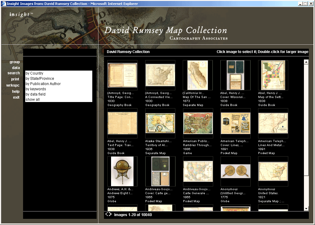
The site offers several options for browsing, from a simple in-brower viewer, to a separate Java client application, to a set of tools for integrating the maps with GIS data. One of those tools even lets you visit the map in three dimensions. For starters, the insight Browser, as shown in Figure 3-3, is probably the easiest to use, though it requires that pop-up ad blocking be turned off. (I switched browsers rather than tinker with settings.)
Figure 3-3. Opening the collection with the insight Browser
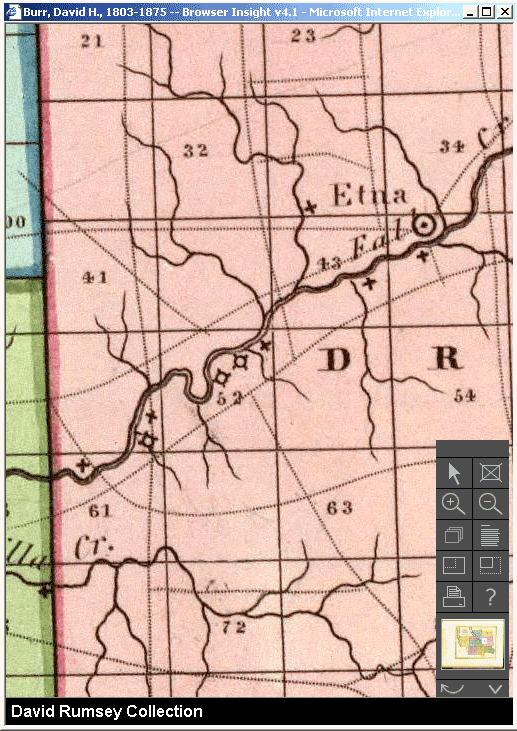
You can wander through all 10,000 maps, or you can search using the options on the lefthand side. I chose to search by State/Province, picked New York from the list, and clicked past the first 100 maps before finding the one I was looking for, in the top left corner of the selection shown in Figure 3-4. Double-clicking on the selected map brings up another window displaying the map and navigation details, as shown in Figure 3-5. Zooming in to a portion of the map where my house now stands, as shown in Figure 3-6, I can see the creek, with sawmills marked by Xs and other mills as circles on Xs, along with the beginnings of the local road system.
Figure 3-4. Maps of upstate New York from 1829
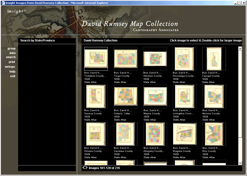
Figure 3-5. An 1829 map of Tompkins County, New York, with options for exploring it
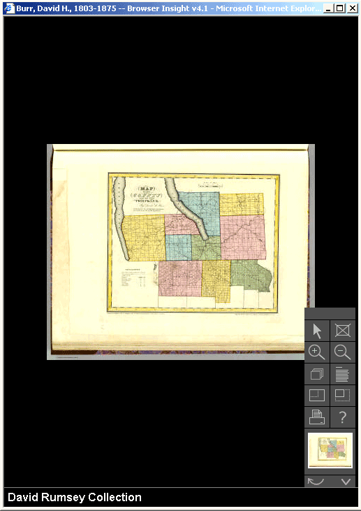
Figure 3-6. Zoomed in on an 1829 map to see the detail available
Most of what you'll want to do in this mode is zoom in and out. The printer button prints a small version of the map on ordinary paper; it's not going to let you take a full image with all the details in the map.
While you can spend hours looking over old maps, the site has a few wilder features to offer as well, notably its 3-D viewing experience at http://davidrumsey.com/GIS/3d.htm. You'll want broadband network access and a reasonably fast computer to use this feature. It crashed my old 600 MHz ThinkPad but ran fine on a 1.8 GHz eMachines with 384 MB of RAM.
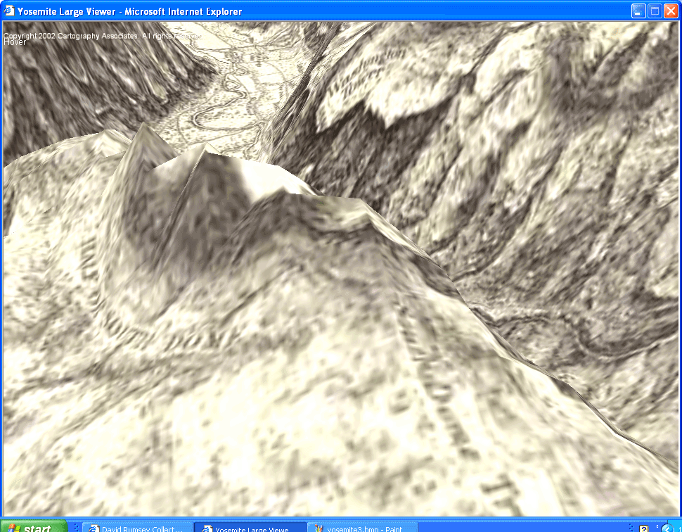
The Yosemite Valley map is the most developed of the six currently available maps, as it starts from an 1883 survey map of the valley and also permits an overlay with much more recent U.S. Geological Survey maps. Using the mouse, arrow keys, and spacebar, you can swoop through the valley, enjoying the detail of the maps, and you can also choose how much of the new map you see through the old map. It's hard to demonstrate the feeling the viewer provides in a book, but Figure 3-7 will give you some idea of what to expect as you explore the valley.
Figure 3-7. Looking over the Yosemite Valley, through a 3-D rendering of an 1883 map
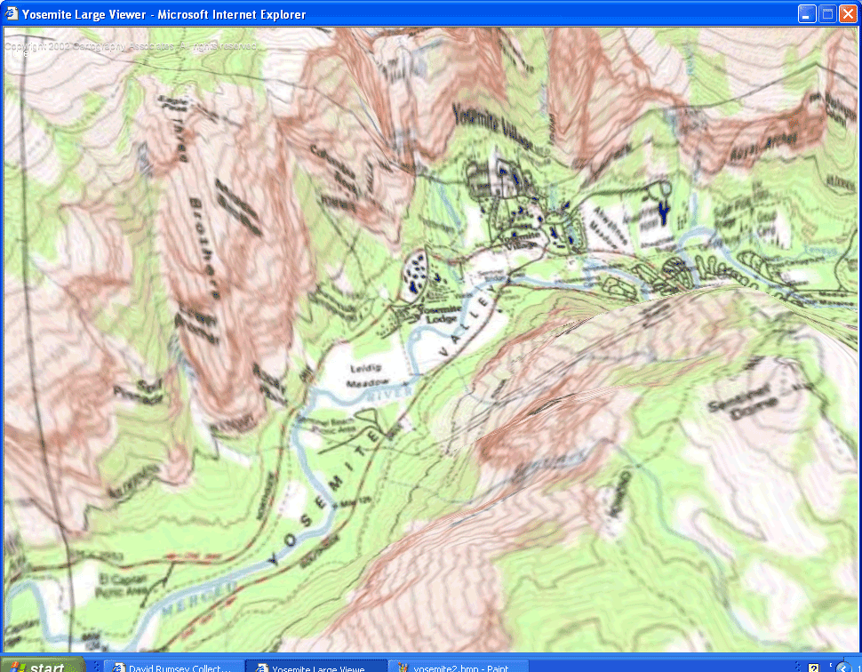
You can also change the view from 1883 to the present using the Z, X, C, V, and B keys. Figures Figure 3-8 through Figure 3-10 show a similar part of the map at different settings.
Figure 3-8. Looking over the Yosemite Valley from Sentinel Dome, using just the 1883 map
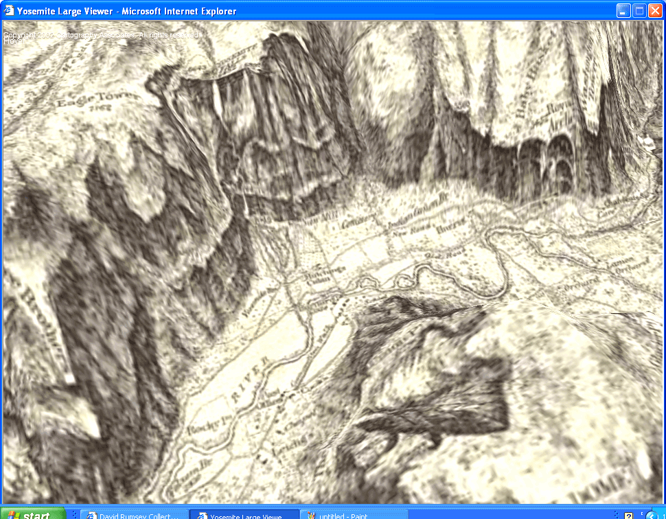
Figure 3-9. Looking over the Yosemite Valley from Sentinel Dome, using both the 1883 map and the USGS map
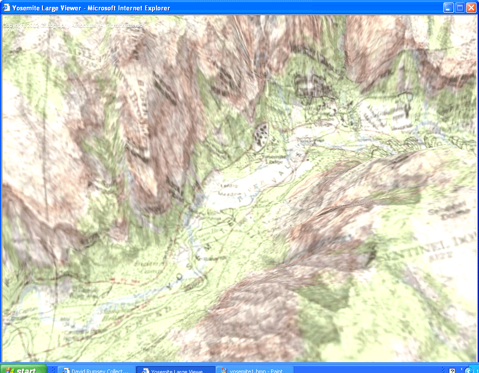
Figure 3-10. Looking over the Yosemite Valley from Sentinel Dome, using just the USGS map
While the 3-D maps are stunning, the collection also offers 2-D maps that combine historical maps with more recent ones through a GIS viewer. Whether you want to explore technical possibilities or stock your wish list with data and tools, the David Rumsey Collection is a fine place to start!
Simon St.Laurent
Mapping Your Life
- Hacks 1-13
- Hack 1. Put a Map on It: Mapping Arbitrary Locations with Online Services
- Hack 2. Route Planning Online
- Hack 3. Map the Places Youve Visited
- Hack 4. Find Your House on an Aerial Photograph
- Hack 5. The Road Less Traveled by in MapQuest
- Hack 6. Make Route Maps Easier to Read
- Hack 7. Will the Kids Barf?
- Hack 8. Publish Maps of Your Photos on the Web
- Hack 9. Track the Friendly Skies with Sherlock
- Hack 10. Georeference Digital Photos
- Hack 11. How Far? How Fast? Geo-Enabling Your Spreadsheet
- Hack 12. Create a Distance Grid in Excel
- Hack 13. Add Maps to Excel Spreadsheets with MapPoint
Mapping Your Neighborhood
- Hacks 14-21
- Hack 14. Make Free Maps of the United States Online
- Hack 15. Zoom Right In on Your Neighborhood
- Hack 16. Who Are the Neighbors Voting For?
- Hack 17. Map Nearby Wi-Fi Hotspots
- Hack 18. Why You Cant Watch Broadcast TV
- Hack 19. Analyze Elevation Profiles for Wireless Community Networks
- Hack 20. Make 3-D Raytraced Terrain Models
- Hack 21. Map Health Code Violations with RDFMapper
Mapping Your World
- Hacks 22-34
- Hack 22. Digging to China
- Hack 23. Explore David Rumseys Historical Maps
- Hack 24. Explore a 3-D Model of the Entire World
- Hack 25. Work with Multiple Lat/Long Formats
- Hack 26. Work with Different Coordinate Systems
- Hack 27. Calculate the Distance Between Points on the Earths Surface
- Hack 28. Experiment with Different Cartographic Projections
- Hack 29. Plot Arbitrary Points on a World Map
- Hack 30. Plot a Great Circle on a Flat Map
- Hack 31. Plot Dymaxion Maps in Perl
- Hack 32. Hack on Base Maps in Your Favorite Image Editor
- Hack 33. Georeference an Arbitrary Tourist Map
- Hack 34. Map Other Planets
Mapping (on) the Web
- Hacks 35-46
- Hack 35. Search Local, Find Global
- Hack 36. Shorten Online Map URLs
- Hack 37. Tweak the Look and Feel of Web Maps
- Hack 38. Add Location to Weblogs and RSS Feeds
- Hack 39. View Your Photo Thumbnails on a Flash Map
- Hack 40. Plot Points on a Spinning Globe Applet
- Hack 41. Plot Points on an Interactive Map Using DHTML
- Hack 42. Map Your Tracklogs on the Web
- Hack 43. Map Earthquakes in (Nearly) Real Time
- Hack 44. Plot Statistics Against Shapes
- Hack 45. Extract a Spatial Model from Wikipedia
- Hack 46. Map Global Weather Conditions
Mapping with Gadgets
- Hacks 47-63
- How GPS Works
- Hack 47. Get Maps on Your Mobile Phone
- Hack 48. Accessorize Your GPS
- Hack 49. Get Your Tracklogs in Windows or Linux
- Hack 50. The Serial Port to USB Conundrum
- Hack 51. Speak in Geotongues: GPSBabel to the Rescue
- Hack 52. Show Your Waypoints on Aerial Photos with Terrabrowser
- Hack 53. Visualize Your Tracks in Three Dimensions
- Hack 54. Create Your Own Maps for a Garmin GPS
- Hack 55. Use Your Track Memory as a GPS Base Map
- Hack 56. Animate Your Tracklogs
- Hack 57. Connect to Your GPS from Multiple Applications
- Hack 58. Dont Lose Your Tracklogs!
- Hack 59. Geocode Your Voice Recordings and Other Media
- Hack 60. Improve the Accuracy of Your GPS with Differential GPS
- Hack 61. Build a Map of Local GSM Cells
- Hack 62. Build a Car Computer
- Hack 63. Build Your Own Car Navigation System with GpsDrive
Mapping on Your Desktop
- Hacks 64-77
- Hack 64. Mapping Local Areas of Interest with Quantum GIS
- Hack 65. Extract Data from Maps with Manifold
- Hack 66. Java-Based Desktop Mapping with Openmap
- Hack 67. Seamless Data Download from the USGS
- Hack 68. Convert Geospatial Data Between Different Formats
- Hack 69. Find Your Way Around GRASS
- Hack 70. Import Your GPS Waypoints and Tracklogs into GRASS
- Hack 71. Turn Your Tracklogs into ESRI Shapefiles
- Hack 72. Add Relief to Your Topographic Maps
- Hack 73. Make Your Own Contour Maps
- Hack 74. Plot Wireless Network Viewsheds with GRASS
- Hack 75. Share Your GRASS Maps with the World
- Hack 76. Explore the Effects of Global Warming
- Conclusion
- Hack 77. Become a GRASS Ninja
Names and Places
- Hacks 78-86
- Hack 78. What to Do if Your Government Is Hoarding Geographic Data
- Hack 79. Geocode a U.S. Street Address
- Hack 80. Automatically Geocode U.S. Addresses
- Hack 81. Clean Up U.S. Addresses
- Hack 82. Find Nearby Things Using U.S. ZIP Codes
- Hack 83. Map Numerical Data the Easy Way
- Hack 84. Build a Free World Gazetteer
- Hack 85. Geocode U.S. Locations with the GNIS
- Hack 86. Track a Package Across the U.S.
Building the Geospatial Web
- Hacks 87-92
- Hack 87. Build a Spatially Indexed Data Store
- Hack 88. Load Your Waypoints into a Spatial Database
- Hack 89. Publish Your Geodata to the Web with GeoServer
- Hack 90. Crawl the Geospatial Web with RedSpider
- Hack 91. Build Interactive Web-Based Map Applications
- Hack 92. Map Wardriving (and other!) Data with MapServer
Mapping with Other People
- Hacks 93-100
- Hack 93. Node Runner
- Hack 94. Geo-Warchalking with 2-D Barcodes
- Hack 95. Model Interactive Spaces
- Hack 96. Share Geo-Photos on the Web
- Hack 97. Set Up an OpenGuide for Your Hometown
- Hack 98. Give Your Great-Great-Grandfather a GPS
- Hack 99. Map Your Friend-of-a-Friend Network
- Hack 100. Map Imaginary Places
EAN: 2147483647
Pages: 172
- Promoting a Slave Name Server to the Primary Master
- Preventing a Name Server from Responding to DNS Traffic from Certain Networks
- Configuring a BIND Name Server to Accommodate a Slave Running the Microsoft DNS Server
- Logging Dynamic Updates
- Configuring a Name Server to Listen for Queries on an IPv6 Interface
