Hack 57. Connect to Your GPS from Multiple Applications


In Linux, BSD, and OS X, you can get live GPS data across different processesand even different computerssimultaneously.
While almost miraculous in their basic operation, your average GPS receiver lacks much in the way of wits all on its own. Even the fanciest of them can do little more than plot your location on a map, and maybe give directions to a destination. Once combined with a computer, though, that same GPS receiver can power a wide range of new and different applications, from auto navigation systems like gpsdrive [Hack #63] to network sensing tools like Kismet and Macstumbler [Hack #17] . However, the very nature of the serial connection linking the twobe it RS-232, USB, or Bluetoothlimits the GPS to talking to one application at a time. As soon as you want to do more than one thing at a time with the data you're getting from that GPS receiver, you will find yourself in a world of sadness and regret.
Fortunately, there is a way around this tragic outcome! For salvation, you can turn to gpsd, a GPS data multiplexer, which runs as a daemon on *NIX operating systems, including OS X. gpsd handles the nitty-gritty details of listening to the GPS receiver and then rebroadcasts the information it receives to other applications over a TCP/IP socket, using a simple text-based protocol. This arrangement allows applications that know how to talk to gpsd to avoid the hassle of needing permissions to set up the serial port or dealing with the specific details of different GPS receivers. Furthermore, since gpsd uses TCP to relay GPS data, a client application can talk to it across a networkor even across the Internet!
5.13.1. Installing gpsd
You can get the source code to gpsd from http://www.pygps.org/gpsd/downloads/. The source code unpacks and builds in the usual way. Use the following commands, in which x.xx is the latest revision of gpsd:
$ tar xvfz gpsd-x.xx.tar.gz
$ cd gpsd-x.xx
$ ./configure
$ make
$ make install
You may get an error something like the following when you run make:
In file included from netlib.c:12:
.../include/varargs.h:4:2: #error "GCC no longer implements ."
.../include/varargs.h:5:2: #error "Revise your code to use ."
If this happens, it's because gpsd was written against gcc headers that your particular system no longer supports. Fortunately, this is easy to fix. Run the following bit of perl, and then run make again. Everything should build just fine:
$ perl -pi -e 's/varargs.h/stdarg.h/g' *.c
$ make
5.13.2. Running gpsd
First, you'll need to make sure your GPS receiver is on and properly connected to your computer (see [Hack #50] if your computer doesn't have a serial port). Next, you'll want to be sure your GPS receiver is configured to output NMEA-0183. Chances are good that the GPS receiver has an option for this in a setup menu, but check your owner's manual to be sure. Several new models of Garmin GPS units no longer speak NMEA. There is discussion of extending gpsd to support the proprietary Garmin protocol, but if you are in the market for a new GPS, you may want to add standards compliance to your list of purchase requirements!
|

Starting gpsd is pretty straightforward. If you've already symlinked /dev/gps to the serial device to which your GPS receiver is typically connected, just enter:
$ /usr/local/sbin/gpsd
However, if you need to explicitly set the serial port or baud rate, you can do that as well:
$ /usr/local/sbin/gpsd -p /dev/ttyS1 -s 4800
Users with a DeLorme EarthMate USB GPS receiver will need to set special options for the EarthMate:
$ /usr/local/sbin/gpsd -Te -s 9600
Once running, gpsd listens on TCP port 2947 for incoming connections. You can test it out by using telnet to type commands directly to gpsd:
$ telnet localhost 2947
Trying 127.0.0.1...
Connected to localhost.
Escape character is '^]'.
s
GPSD,S=0
s
GPSD,S=1
p
GPSD,P=37.739000 -122.419000
Commands to gpsd take the form of one or more letters, followed by a new line. Each letter is a single command. The s command, for example, requests the status of the GPS connection, returning a 1 if the GPS is connected, and a 0 if it's not. This can be useful for testing purposes, but, as you can see, gpsd doesn't always return a successful status on the first try, so give it a couple tries before deciding that you need to troubleshoot the connection. As you can see, the p command requests the current position. Another useful command for debugging is r, which requests a raw dump of the NMEA data:
r
GPSD,R=1
$GPRMC,085400,A,3744.0000,N,12225.0000,W,0.0,359.6,060804,15.1,E,A*39
$GPRMB,A,9.99,R,,Exit 192,4402.6514,N,12302.9773,W,379.131,355.9,,V,A*42
$GPGGA,085400,3744.3751,N,12225.1963,W,1,05,2.5,81.1,M,-28.1,M,,*4A
r
GPSD,R=0
Pretty ugly, huh? A second r command terminates the raw dump. Control-] followed by quit gets you out of telnet. Table 5-1 lists some other gpsd commands.
|
Command |
Description |
|---|---|
|
p |
Latitude/longitude, in decimal degrees. |
|
d |
Date/time, in MM/DD/YYYY HH:MM:SS format. |
|
a |
Altitude, in meters. |
|
v |
Current speed, in knots. |
|
s |
GPS status (0 = Disconnected; 1 = No GPS Fix; 2 = 2-D Fix; 3 = 3-D Fix) |
|
m |
Operating mode (0 = Disconnected; 1 = GPS; 2 = DGPS / WAAS) |
5.13.3. Visualizing the Output of gpsd
Another useful tool that ships with gpsd is called, simply, gps, and it's an X11 program for visualizing gpsd output. You start it by running /usr/local/bin/gps. Figure 5-29 shows a typical gps display, including the nifty satellite visibility chart.
Figure 5-29. A typical gps display
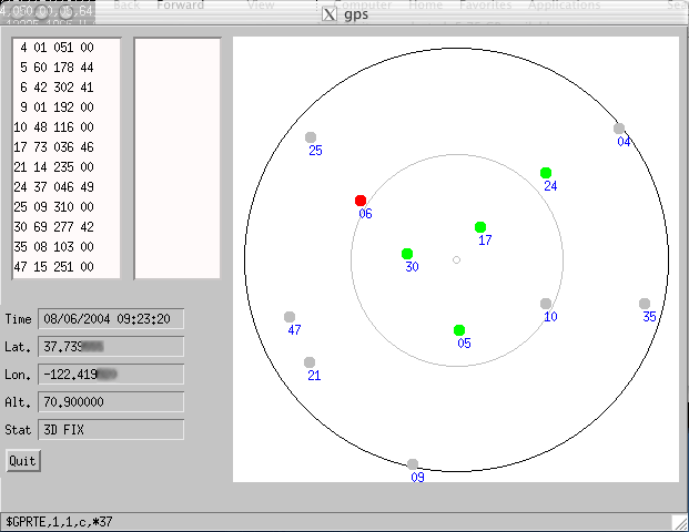
What's particularly cool about this screenshot is that it was taken on a different machine than the one the GPS was connected to; the two computers were connected via a wireless network, with gpsd running on the one with the serial link to the GPS. We then ran gps -p x.x.x.x:2947 on the other laptop, where x.x.x.x was the IP address of the gpsd machine, and voilà!
5.13.4. Hacking the Hack
At this point, you should be ready to run kismet [Hack #17] or gpsdrive [Hack #63], or kismet and gpsdrive together, or, indeed, your choice of GPS-using *NIX applications. The nice thing about gpsd is that once you've got it running, you can kind of forget about it. So we'd like to share with you just one more thing you can do with gpsd, which is to set up a little CGI application on the Web that shows your current location in real time:
#!/usr/bin/perl use CGI; use CGI::Carp 'fatalsToBrowser'; use IO::Socket::INET; use strict; my $GPSD_Server = "yourhostname.here:2947"; my $Map_Width = 0.25; # degrees my $Map_Pixels = 320; ###### my $gpsd = IO::Socket::INET->new( $GPSD_Server ) or die "Couldn't connect to GPS server. "; my $data = <$gpsd>; my ($lat, $lon) = ($data =~ /(-?d+.d+) (-?d+.d+)/gos); my $map = "http://tiger.census.gov/cgi-bin/mapgen?" . "lon=$lon&lat=$lat&wid=$Map_Width&ht=$Map_Width" . "&iht=$Map_Pixels&iwd=$Map_Pixels" . "&mark=$lon,$lat,redpin"; print CGI->header, <Where am I?
Where am I?
($lat, $lon)
End
This CGI script connects to a gpsd running on the server specified by $GPSD_Server, fetches the current latitude and longitude, and shows the location on a TIGER Map Server map [Hack #14] . If you have a *NIX laptop running gpsd, and a Net connection with some kind of dynamic DNS alias, this script could live on a web server on the Internet and connect to your laptop on demand to give others a general idea of your whereabouts. Assuming you were somewhere in the U.S. at the time, interested parties would see something like Figure 5-30.
Figure 5-30. Where am I? Live, thanks to gpsd
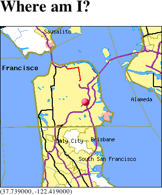
Although this example is a bit contrived (and does almost no error checking to speak of), it demonstrates the simplicity and power of gpsd. You can find out more about gpsd at http://gpsd.berlios.de.
5.13.5. See Also
- [Hack #50]
- [Hack #58]
- [Hack #14]
- [Hack #17]
- [Hack #63]
Mapping Your Life
- Hacks 1-13
- Hack 1. Put a Map on It: Mapping Arbitrary Locations with Online Services
- Hack 2. Route Planning Online
- Hack 3. Map the Places Youve Visited
- Hack 4. Find Your House on an Aerial Photograph
- Hack 5. The Road Less Traveled by in MapQuest
- Hack 6. Make Route Maps Easier to Read
- Hack 7. Will the Kids Barf?
- Hack 8. Publish Maps of Your Photos on the Web
- Hack 9. Track the Friendly Skies with Sherlock
- Hack 10. Georeference Digital Photos
- Hack 11. How Far? How Fast? Geo-Enabling Your Spreadsheet
- Hack 12. Create a Distance Grid in Excel
- Hack 13. Add Maps to Excel Spreadsheets with MapPoint
Mapping Your Neighborhood
- Hacks 14-21
- Hack 14. Make Free Maps of the United States Online
- Hack 15. Zoom Right In on Your Neighborhood
- Hack 16. Who Are the Neighbors Voting For?
- Hack 17. Map Nearby Wi-Fi Hotspots
- Hack 18. Why You Cant Watch Broadcast TV
- Hack 19. Analyze Elevation Profiles for Wireless Community Networks
- Hack 20. Make 3-D Raytraced Terrain Models
- Hack 21. Map Health Code Violations with RDFMapper
Mapping Your World
- Hacks 22-34
- Hack 22. Digging to China
- Hack 23. Explore David Rumseys Historical Maps
- Hack 24. Explore a 3-D Model of the Entire World
- Hack 25. Work with Multiple Lat/Long Formats
- Hack 26. Work with Different Coordinate Systems
- Hack 27. Calculate the Distance Between Points on the Earths Surface
- Hack 28. Experiment with Different Cartographic Projections
- Hack 29. Plot Arbitrary Points on a World Map
- Hack 30. Plot a Great Circle on a Flat Map
- Hack 31. Plot Dymaxion Maps in Perl
- Hack 32. Hack on Base Maps in Your Favorite Image Editor
- Hack 33. Georeference an Arbitrary Tourist Map
- Hack 34. Map Other Planets
Mapping (on) the Web
- Hacks 35-46
- Hack 35. Search Local, Find Global
- Hack 36. Shorten Online Map URLs
- Hack 37. Tweak the Look and Feel of Web Maps
- Hack 38. Add Location to Weblogs and RSS Feeds
- Hack 39. View Your Photo Thumbnails on a Flash Map
- Hack 40. Plot Points on a Spinning Globe Applet
- Hack 41. Plot Points on an Interactive Map Using DHTML
- Hack 42. Map Your Tracklogs on the Web
- Hack 43. Map Earthquakes in (Nearly) Real Time
- Hack 44. Plot Statistics Against Shapes
- Hack 45. Extract a Spatial Model from Wikipedia
- Hack 46. Map Global Weather Conditions
Mapping with Gadgets
- Hacks 47-63
- How GPS Works
- Hack 47. Get Maps on Your Mobile Phone
- Hack 48. Accessorize Your GPS
- Hack 49. Get Your Tracklogs in Windows or Linux
- Hack 50. The Serial Port to USB Conundrum
- Hack 51. Speak in Geotongues: GPSBabel to the Rescue
- Hack 52. Show Your Waypoints on Aerial Photos with Terrabrowser
- Hack 53. Visualize Your Tracks in Three Dimensions
- Hack 54. Create Your Own Maps for a Garmin GPS
- Hack 55. Use Your Track Memory as a GPS Base Map
- Hack 56. Animate Your Tracklogs
- Hack 57. Connect to Your GPS from Multiple Applications
- Hack 58. Dont Lose Your Tracklogs!
- Hack 59. Geocode Your Voice Recordings and Other Media
- Hack 60. Improve the Accuracy of Your GPS with Differential GPS
- Hack 61. Build a Map of Local GSM Cells
- Hack 62. Build a Car Computer
- Hack 63. Build Your Own Car Navigation System with GpsDrive
Mapping on Your Desktop
- Hacks 64-77
- Hack 64. Mapping Local Areas of Interest with Quantum GIS
- Hack 65. Extract Data from Maps with Manifold
- Hack 66. Java-Based Desktop Mapping with Openmap
- Hack 67. Seamless Data Download from the USGS
- Hack 68. Convert Geospatial Data Between Different Formats
- Hack 69. Find Your Way Around GRASS
- Hack 70. Import Your GPS Waypoints and Tracklogs into GRASS
- Hack 71. Turn Your Tracklogs into ESRI Shapefiles
- Hack 72. Add Relief to Your Topographic Maps
- Hack 73. Make Your Own Contour Maps
- Hack 74. Plot Wireless Network Viewsheds with GRASS
- Hack 75. Share Your GRASS Maps with the World
- Hack 76. Explore the Effects of Global Warming
- Conclusion
- Hack 77. Become a GRASS Ninja
Names and Places
- Hacks 78-86
- Hack 78. What to Do if Your Government Is Hoarding Geographic Data
- Hack 79. Geocode a U.S. Street Address
- Hack 80. Automatically Geocode U.S. Addresses
- Hack 81. Clean Up U.S. Addresses
- Hack 82. Find Nearby Things Using U.S. ZIP Codes
- Hack 83. Map Numerical Data the Easy Way
- Hack 84. Build a Free World Gazetteer
- Hack 85. Geocode U.S. Locations with the GNIS
- Hack 86. Track a Package Across the U.S.
Building the Geospatial Web
- Hacks 87-92
- Hack 87. Build a Spatially Indexed Data Store
- Hack 88. Load Your Waypoints into a Spatial Database
- Hack 89. Publish Your Geodata to the Web with GeoServer
- Hack 90. Crawl the Geospatial Web with RedSpider
- Hack 91. Build Interactive Web-Based Map Applications
- Hack 92. Map Wardriving (and other!) Data with MapServer
Mapping with Other People
- Hacks 93-100
- Hack 93. Node Runner
- Hack 94. Geo-Warchalking with 2-D Barcodes
- Hack 95. Model Interactive Spaces
- Hack 96. Share Geo-Photos on the Web
- Hack 97. Set Up an OpenGuide for Your Hometown
- Hack 98. Give Your Great-Great-Grandfather a GPS
- Hack 99. Map Your Friend-of-a-Friend Network
- Hack 100. Map Imaginary Places
EAN: 2147483647
Pages: 172
