Hack 19. Analyze Elevation Profiles for Wireless Community Networks


A web application and a few digital elevation models can significantly ease the pain of building wireless community networks in remote areas.
If you're trying to build wireless community networks out in the hills, like the NoCat Network has done in Sonoma County, California, the first thing you discover is that hills eat Wi-Fi signals for lunch. Modern wireless networking technologies, like 802.11b, need a line of sight to establish a connection, and any significant amount of intervening terrain, trees, or buildings between two points will quickly ruin your chances of setting up a long-distance, point-to-point wireless connection. In places where DSL and cable are unavailable, however, point-to-point community wireless links are often the only way that local residents can get high-speed Internet connectivity, so there's often a lot of motivation to find ways to work with the surrounding terrain.
Naturally, the first question a newbie asks when he shows up at a community network meeting is, "Can I get on the network?" The answer is, inevitably, "That depends. Where do you live?" Armed with the GPS coordinates of the newbie's house, you can do a certain amount of terrain analysis using digital elevation models (DEMs) in commercial software like TopoUSA or free software like GRASS. The downside to this is that, if you have 50 would-be participants in a community network, then the total number of possible links to evaluate is, apropos of nothing else, 50 x 49 2 = 1225. That's a lot of work to do by hand!
There had to be a better way. Our ambition was to create a tool that would allow a community member to get their house on the NoCat Network with nothing more than a compass and a Wi-Fi card with a high-gain antenna. We demonstrated that, using GRASS, we could extract elevations from 10-meter-resolution USGS DEMs along the line connecting two locations and use them to plot a contour profile with Perl and the GD::Graph module from the CPAN. If the elevation of the straight line in three dimensions between those two points is less than or equal to the elevation at any point along that line, then there's a hill in the way, and a link probably won't be feasible. If the elevation of the line of sight is above ground elevation along the whole distance, then a wireless connection might be possible (but see the caveats mentioned later in this hack).
We took the contour profiler from GRASS and combined it with a web-based network node database, so that any new locations would be automatically tested against all existing locations for link viability. Finally, we added a rudimentary address geocoder based on TIGER/Line for users who didn't know their GPS coordinates already. The result was NoCat Maps, which now lives at http://maps.nocat.net/.
Now, when people come to NoCat Network meetings and ask how they can get on the network, they're told to go to the web site and add themselves to the database. If they know their GPS coordinates, they can enter them there; otherwise, their address is looked up in the TIGER/Line database of Sonoma County. The application analyzes the elevation profile along the line of sight to every other possible node and then presents the user with a list of possible connections, as shown in Figure 2-16.
Figure 2-16. View likely point-to-point links at a glance
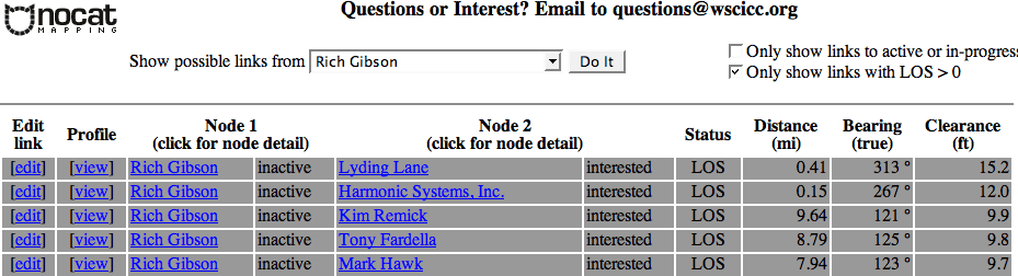
The listing of possible links comes sorted by clearance, approximately how much room a link has to spare, given the intervening terrain, ignoring Fresnel zones and so on. Antennas are assumed to be at least 5 meters off the ground, so the maximum possible clearance is about 16 feet. A negative clearance indicates the presence of a hill at least that high in the way. Additionally, since we know the latitude and longitude of both points, we can calculate the straight-line distance and true bearing for each possible link. This means that, if you know that there's a live antenna at a given node and NoCat Maps suggests that a link might be possible, you can go outside with a Wi-Fi card, your own high-gain antenna, and a compass and give it a shot, before you ever show up at a meeting.
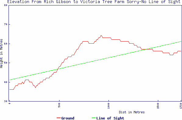
The original contour profile has been preserved, as well. If you click the "View" link next to any pair of nodes in the node listing, you get a PNG file depicting the line of sight and the elevation profile between them. Figure 2-17 shows a potentially successful link, while Figure 2-18 shows one doomed to failure.
Figure 2-17. One possible point-to-point link
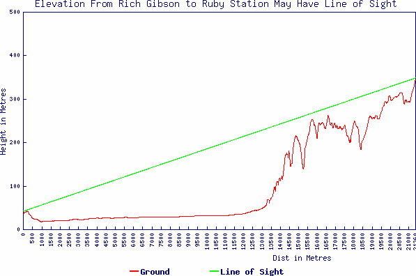
Figure 2-18. This is not the link you are looking formove along
What are the caveats of using such an application? First, the data takes no account whatsoever of ground clutteri.e., buildings, trees, etc. Realistically, it's difficult to do so, because these things change a bit from month to month and year to year. One approach, suggested by Jerritt Collord, might be to integrate the 30-meter-resolution Shuttle Radar Topography Mission (SRTM) data, which could be compared against a matching DEM to infer the presence of ground clutter.
However, even were we to correlate against SRTM data, we'd still run into the other general caveat of NoCat Maps, which is that the resolution of the DEMs isn't perfect for the task. Experience shows that 10 meters in one direction or another can easily be make-or-break for a wireless link, much less 30 meters. As a result, NoCat Maps does rate some proven, working wireless links as being impossible, and it calls some other links possible that later turn out not to be. The practical upshot is that NoCat Maps is intended to provide a rule of thumb, a starting point for planning community networks, rather than a definitive resource. If a link looks marginal, it's often worth trying anyway!
Creating an application like NoCat Maps has become much easier in the last three years. For starters, you no longer need to create your own custom geocoder to get the latitude and longitude of a particular street address; instead, you can use geocoder.us, as described in [Hack #79] and [Hack #80] . One can also lighten the load of the application quite a bit by using the Geo::GDAL Perl module from the CPAN to directly access DEM files, instead of having to integrate with GRASS. There are plans afoot to improve NoCat Maps and to publish a new version of the software under the GPL, so that anyone can download and implement a NoCat Map database for her own community network. We recommend checking http://maps.nocat.net/ for more details.
Mapping Your Life
- Hacks 1-13
- Hack 1. Put a Map on It: Mapping Arbitrary Locations with Online Services
- Hack 2. Route Planning Online
- Hack 3. Map the Places Youve Visited
- Hack 4. Find Your House on an Aerial Photograph
- Hack 5. The Road Less Traveled by in MapQuest
- Hack 6. Make Route Maps Easier to Read
- Hack 7. Will the Kids Barf?
- Hack 8. Publish Maps of Your Photos on the Web
- Hack 9. Track the Friendly Skies with Sherlock
- Hack 10. Georeference Digital Photos
- Hack 11. How Far? How Fast? Geo-Enabling Your Spreadsheet
- Hack 12. Create a Distance Grid in Excel
- Hack 13. Add Maps to Excel Spreadsheets with MapPoint
Mapping Your Neighborhood
- Hacks 14-21
- Hack 14. Make Free Maps of the United States Online
- Hack 15. Zoom Right In on Your Neighborhood
- Hack 16. Who Are the Neighbors Voting For?
- Hack 17. Map Nearby Wi-Fi Hotspots
- Hack 18. Why You Cant Watch Broadcast TV
- Hack 19. Analyze Elevation Profiles for Wireless Community Networks
- Hack 20. Make 3-D Raytraced Terrain Models
- Hack 21. Map Health Code Violations with RDFMapper
Mapping Your World
- Hacks 22-34
- Hack 22. Digging to China
- Hack 23. Explore David Rumseys Historical Maps
- Hack 24. Explore a 3-D Model of the Entire World
- Hack 25. Work with Multiple Lat/Long Formats
- Hack 26. Work with Different Coordinate Systems
- Hack 27. Calculate the Distance Between Points on the Earths Surface
- Hack 28. Experiment with Different Cartographic Projections
- Hack 29. Plot Arbitrary Points on a World Map
- Hack 30. Plot a Great Circle on a Flat Map
- Hack 31. Plot Dymaxion Maps in Perl
- Hack 32. Hack on Base Maps in Your Favorite Image Editor
- Hack 33. Georeference an Arbitrary Tourist Map
- Hack 34. Map Other Planets
Mapping (on) the Web
- Hacks 35-46
- Hack 35. Search Local, Find Global
- Hack 36. Shorten Online Map URLs
- Hack 37. Tweak the Look and Feel of Web Maps
- Hack 38. Add Location to Weblogs and RSS Feeds
- Hack 39. View Your Photo Thumbnails on a Flash Map
- Hack 40. Plot Points on a Spinning Globe Applet
- Hack 41. Plot Points on an Interactive Map Using DHTML
- Hack 42. Map Your Tracklogs on the Web
- Hack 43. Map Earthquakes in (Nearly) Real Time
- Hack 44. Plot Statistics Against Shapes
- Hack 45. Extract a Spatial Model from Wikipedia
- Hack 46. Map Global Weather Conditions
Mapping with Gadgets
- Hacks 47-63
- How GPS Works
- Hack 47. Get Maps on Your Mobile Phone
- Hack 48. Accessorize Your GPS
- Hack 49. Get Your Tracklogs in Windows or Linux
- Hack 50. The Serial Port to USB Conundrum
- Hack 51. Speak in Geotongues: GPSBabel to the Rescue
- Hack 52. Show Your Waypoints on Aerial Photos with Terrabrowser
- Hack 53. Visualize Your Tracks in Three Dimensions
- Hack 54. Create Your Own Maps for a Garmin GPS
- Hack 55. Use Your Track Memory as a GPS Base Map
- Hack 56. Animate Your Tracklogs
- Hack 57. Connect to Your GPS from Multiple Applications
- Hack 58. Dont Lose Your Tracklogs!
- Hack 59. Geocode Your Voice Recordings and Other Media
- Hack 60. Improve the Accuracy of Your GPS with Differential GPS
- Hack 61. Build a Map of Local GSM Cells
- Hack 62. Build a Car Computer
- Hack 63. Build Your Own Car Navigation System with GpsDrive
Mapping on Your Desktop
- Hacks 64-77
- Hack 64. Mapping Local Areas of Interest with Quantum GIS
- Hack 65. Extract Data from Maps with Manifold
- Hack 66. Java-Based Desktop Mapping with Openmap
- Hack 67. Seamless Data Download from the USGS
- Hack 68. Convert Geospatial Data Between Different Formats
- Hack 69. Find Your Way Around GRASS
- Hack 70. Import Your GPS Waypoints and Tracklogs into GRASS
- Hack 71. Turn Your Tracklogs into ESRI Shapefiles
- Hack 72. Add Relief to Your Topographic Maps
- Hack 73. Make Your Own Contour Maps
- Hack 74. Plot Wireless Network Viewsheds with GRASS
- Hack 75. Share Your GRASS Maps with the World
- Hack 76. Explore the Effects of Global Warming
- Conclusion
- Hack 77. Become a GRASS Ninja
Names and Places
- Hacks 78-86
- Hack 78. What to Do if Your Government Is Hoarding Geographic Data
- Hack 79. Geocode a U.S. Street Address
- Hack 80. Automatically Geocode U.S. Addresses
- Hack 81. Clean Up U.S. Addresses
- Hack 82. Find Nearby Things Using U.S. ZIP Codes
- Hack 83. Map Numerical Data the Easy Way
- Hack 84. Build a Free World Gazetteer
- Hack 85. Geocode U.S. Locations with the GNIS
- Hack 86. Track a Package Across the U.S.
Building the Geospatial Web
- Hacks 87-92
- Hack 87. Build a Spatially Indexed Data Store
- Hack 88. Load Your Waypoints into a Spatial Database
- Hack 89. Publish Your Geodata to the Web with GeoServer
- Hack 90. Crawl the Geospatial Web with RedSpider
- Hack 91. Build Interactive Web-Based Map Applications
- Hack 92. Map Wardriving (and other!) Data with MapServer
Mapping with Other People
- Hacks 93-100
- Hack 93. Node Runner
- Hack 94. Geo-Warchalking with 2-D Barcodes
- Hack 95. Model Interactive Spaces
- Hack 96. Share Geo-Photos on the Web
- Hack 97. Set Up an OpenGuide for Your Hometown
- Hack 98. Give Your Great-Great-Grandfather a GPS
- Hack 99. Map Your Friend-of-a-Friend Network
- Hack 100. Map Imaginary Places
EAN: 2147483647
Pages: 172
