Hack 24. Explore a 3-D Model of the Entire World


NASA's World Wind software lets you explore an unbelievable wealth of geospatial imagery, rendered in 3-D in real time.
World Wind is a newcomer to the world of GIS software. Similar in premise to the shiny but ultimately rather expensive Keyhole package (http://www.keyhole.com/), NASA's World Wind application allows you to explore a real-time 3-D rendering of planet Earth from orbit all the way down to ground level, using your keyboard and mouse to navigate. The package is available for freeas in both beer and speechand has access to over 20 terabytes of data, including Landsat and Terraserver imagery, USGS topo maps, and much more. World Wind loads and caches its data sets dynamically as you zoom in, so broadband and a fast graphics card are an absolute must!
3.4.1. Getting the Software
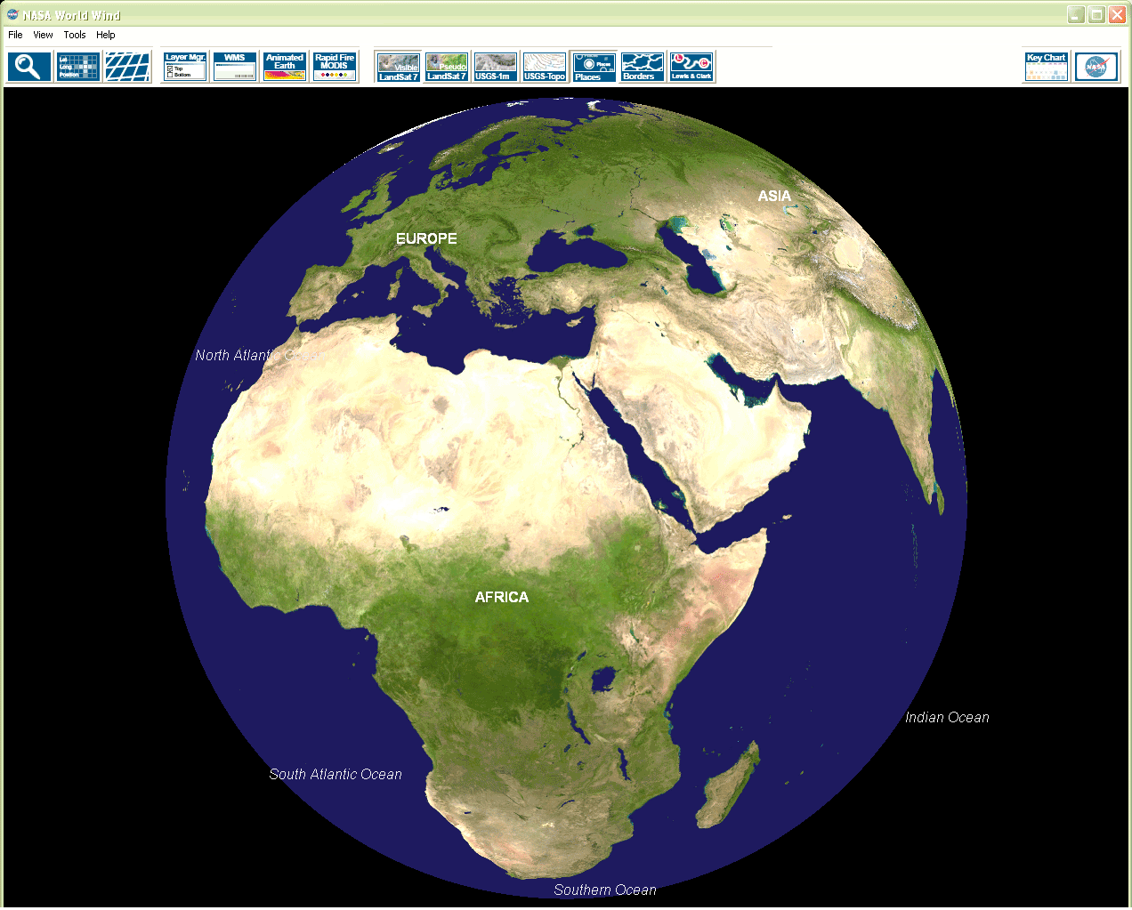
First off, go to http://learn.arc.nasa.gov/worldwind/ and grab a copy of the software. At 235 MB, it's a hefty download, but that constitutes the "starter set" of data needed by the application. Double-click on the .exe file, and it will install like any other Windows application. Make sure you pick a location on your hard drive that has plenty of space, because as you zoom around on the globe and use various features, you will begin to download and store a lot of data on your computer. If the application is installed correctly, you will be greeted with a nice Blue Marble-textured globe, as shown in Figure 3-11.
Figure 3-11. World Wind's startup view
3.4.2. Basic Navigation
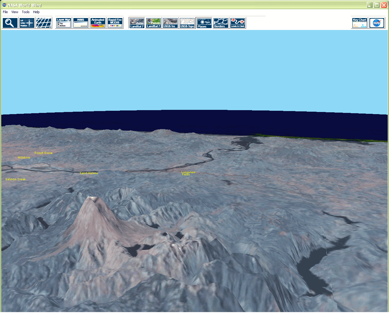
Navigation is pretty simple. Hold down the left mouse button and move the mouse to rotate the globe. You can use the scroll wheel, or hold down the left and right mouse buttons together to zoom the scene. Holding down the right mouse button alone allows you to use the mouse to tilt the scene, and if there is elevation data for the area, you will be treated to a 3-D view like Figure 3-12. If you just click on the screen, it will center your view to that point. If you click on the "Key Chart" icon in the upper right corner, you can get a list of all the keyboard navigation options as well.
Figure 3-12. Mt. St. Helens, as rendered in World Wind
Once you zoom in to a certain altitude, you will see a NASA logo in the upper right corner and a red rectangle on the map. This icon lets you know that World Wind is requesting more data over the network, so be patient.
3.4.3. Exploring the Available Data Sets
World Wind has many data sets you can play with:
Blue Marble
The textured globe you see when you start the application.
Landsat 7
The default data set when you zoom in. The resolution of Landsat 7 is 15 meters per pixel. There are two varieties, normal and "pseudo," which is a false color map produced using the infrared bands in Landsat imagery.
Shuttle Radar Topography Mission (SRTM)
Digital elevation data for a given area. If you tilt the view by holding down the right mouse button and moving the mouse, you will be able to see mountains and valleys.
USGS/Terraserver 1 meter
The Terraserver images are the highest-detail maps World Wind can use at the moment. With these, you can see cars and swimming pools.
USGS Topo
These are the traditional hand-drawn USGS contour maps of a given area.
These data sets are activated by the icons across the top of the application, as shown in Figure 3-11. They can also be manipulated by the Layer Manager, by going to Tools images/ent/U2192.GIF border=0> Layer Manager.
There are three specialty data sets that World Wind can use as well:
MODIS
NASA's MODIS satellite data is used to provide markers that point out notable meteorological and geological events happing all over the globe: storms, fires, floods, and even volcanoes. If you click on the markers, you can get high-resolution images of the events at a point in time.
Living Earth
These are various animations of phenomena on Earth produced by the Goddard Space Flight Center. Everything from hurricanes in Florida to sandstorms in China to fires in Yellowstone.
GLOBE
The GLOBE data set is primarily composed of various statistics gathered from the surface of the earth: rainfall, temperature, humidity, etc.
All these specialty sets can be explored under the Tools menu.
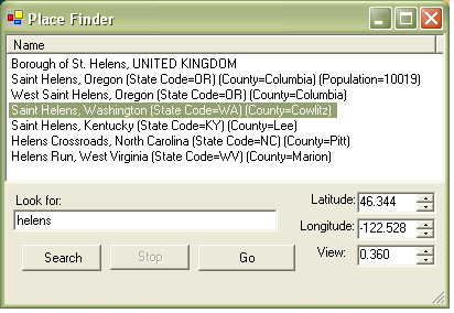
World Wind also features over four million place names and boundary lines for countries and states, which you can view by selecting the "Borders and Places" icon on the toolbar. If you click on the big magnifying glass icon or go to Tools images/ent/U2192.GIF border=0> Place Finder, you will get a dialog box where you can type in a name to be taken directly to that location, as shown in Figure 3-13.
Figure 3-13. World Wind's Place Finder dialog
3.4.4. A Sneak Peek into the Past
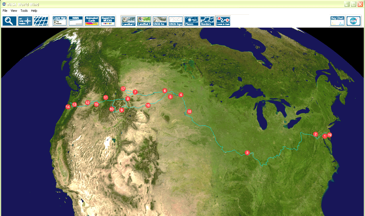
Since World Wind is part of a NASA initiative to help educators, they are providing a peek at some future features of the program. If you click on the "Lewis and Clark" icon in the toolbar, World Wind will overlay the route Lewis and Clark took on their journeys, as shown in Figure 3-14. The numbered icons are interactive, and clicking on them will open a journal entry on the Lewis and Clark web site (http://www.lewis-clark.org/).
Figure 3-14. Lewis and Clark's journey, as shown in World Wind
Currently, there are no end-user tools to build the overlay files, but since this is an open source project, hopefully the tools will be forthcoming.
3.4.5. Final Thoughts
Until now, a desktop-mapping application of this magnitude would have been a pretty ambitious project, but it seems like NASA has pulled it off with World Wind. There is no SourceForge repository for it, but there is an active community in their forums, located at http://learn.arc.nasa.gov/worldwind/forums/. Thanks to Moore's Law, we now have the ability to play this data back on the hardware on our desktop. How far we have come from vellum and quill pens!
Adam Hill
Mapping Your Life
- Hacks 1-13
- Hack 1. Put a Map on It: Mapping Arbitrary Locations with Online Services
- Hack 2. Route Planning Online
- Hack 3. Map the Places Youve Visited
- Hack 4. Find Your House on an Aerial Photograph
- Hack 5. The Road Less Traveled by in MapQuest
- Hack 6. Make Route Maps Easier to Read
- Hack 7. Will the Kids Barf?
- Hack 8. Publish Maps of Your Photos on the Web
- Hack 9. Track the Friendly Skies with Sherlock
- Hack 10. Georeference Digital Photos
- Hack 11. How Far? How Fast? Geo-Enabling Your Spreadsheet
- Hack 12. Create a Distance Grid in Excel
- Hack 13. Add Maps to Excel Spreadsheets with MapPoint
Mapping Your Neighborhood
- Hacks 14-21
- Hack 14. Make Free Maps of the United States Online
- Hack 15. Zoom Right In on Your Neighborhood
- Hack 16. Who Are the Neighbors Voting For?
- Hack 17. Map Nearby Wi-Fi Hotspots
- Hack 18. Why You Cant Watch Broadcast TV
- Hack 19. Analyze Elevation Profiles for Wireless Community Networks
- Hack 20. Make 3-D Raytraced Terrain Models
- Hack 21. Map Health Code Violations with RDFMapper
Mapping Your World
- Hacks 22-34
- Hack 22. Digging to China
- Hack 23. Explore David Rumseys Historical Maps
- Hack 24. Explore a 3-D Model of the Entire World
- Hack 25. Work with Multiple Lat/Long Formats
- Hack 26. Work with Different Coordinate Systems
- Hack 27. Calculate the Distance Between Points on the Earths Surface
- Hack 28. Experiment with Different Cartographic Projections
- Hack 29. Plot Arbitrary Points on a World Map
- Hack 30. Plot a Great Circle on a Flat Map
- Hack 31. Plot Dymaxion Maps in Perl
- Hack 32. Hack on Base Maps in Your Favorite Image Editor
- Hack 33. Georeference an Arbitrary Tourist Map
- Hack 34. Map Other Planets
Mapping (on) the Web
- Hacks 35-46
- Hack 35. Search Local, Find Global
- Hack 36. Shorten Online Map URLs
- Hack 37. Tweak the Look and Feel of Web Maps
- Hack 38. Add Location to Weblogs and RSS Feeds
- Hack 39. View Your Photo Thumbnails on a Flash Map
- Hack 40. Plot Points on a Spinning Globe Applet
- Hack 41. Plot Points on an Interactive Map Using DHTML
- Hack 42. Map Your Tracklogs on the Web
- Hack 43. Map Earthquakes in (Nearly) Real Time
- Hack 44. Plot Statistics Against Shapes
- Hack 45. Extract a Spatial Model from Wikipedia
- Hack 46. Map Global Weather Conditions
Mapping with Gadgets
- Hacks 47-63
- How GPS Works
- Hack 47. Get Maps on Your Mobile Phone
- Hack 48. Accessorize Your GPS
- Hack 49. Get Your Tracklogs in Windows or Linux
- Hack 50. The Serial Port to USB Conundrum
- Hack 51. Speak in Geotongues: GPSBabel to the Rescue
- Hack 52. Show Your Waypoints on Aerial Photos with Terrabrowser
- Hack 53. Visualize Your Tracks in Three Dimensions
- Hack 54. Create Your Own Maps for a Garmin GPS
- Hack 55. Use Your Track Memory as a GPS Base Map
- Hack 56. Animate Your Tracklogs
- Hack 57. Connect to Your GPS from Multiple Applications
- Hack 58. Dont Lose Your Tracklogs!
- Hack 59. Geocode Your Voice Recordings and Other Media
- Hack 60. Improve the Accuracy of Your GPS with Differential GPS
- Hack 61. Build a Map of Local GSM Cells
- Hack 62. Build a Car Computer
- Hack 63. Build Your Own Car Navigation System with GpsDrive
Mapping on Your Desktop
- Hacks 64-77
- Hack 64. Mapping Local Areas of Interest with Quantum GIS
- Hack 65. Extract Data from Maps with Manifold
- Hack 66. Java-Based Desktop Mapping with Openmap
- Hack 67. Seamless Data Download from the USGS
- Hack 68. Convert Geospatial Data Between Different Formats
- Hack 69. Find Your Way Around GRASS
- Hack 70. Import Your GPS Waypoints and Tracklogs into GRASS
- Hack 71. Turn Your Tracklogs into ESRI Shapefiles
- Hack 72. Add Relief to Your Topographic Maps
- Hack 73. Make Your Own Contour Maps
- Hack 74. Plot Wireless Network Viewsheds with GRASS
- Hack 75. Share Your GRASS Maps with the World
- Hack 76. Explore the Effects of Global Warming
- Conclusion
- Hack 77. Become a GRASS Ninja
Names and Places
- Hacks 78-86
- Hack 78. What to Do if Your Government Is Hoarding Geographic Data
- Hack 79. Geocode a U.S. Street Address
- Hack 80. Automatically Geocode U.S. Addresses
- Hack 81. Clean Up U.S. Addresses
- Hack 82. Find Nearby Things Using U.S. ZIP Codes
- Hack 83. Map Numerical Data the Easy Way
- Hack 84. Build a Free World Gazetteer
- Hack 85. Geocode U.S. Locations with the GNIS
- Hack 86. Track a Package Across the U.S.
Building the Geospatial Web
- Hacks 87-92
- Hack 87. Build a Spatially Indexed Data Store
- Hack 88. Load Your Waypoints into a Spatial Database
- Hack 89. Publish Your Geodata to the Web with GeoServer
- Hack 90. Crawl the Geospatial Web with RedSpider
- Hack 91. Build Interactive Web-Based Map Applications
- Hack 92. Map Wardriving (and other!) Data with MapServer
Mapping with Other People
- Hacks 93-100
- Hack 93. Node Runner
- Hack 94. Geo-Warchalking with 2-D Barcodes
- Hack 95. Model Interactive Spaces
- Hack 96. Share Geo-Photos on the Web
- Hack 97. Set Up an OpenGuide for Your Hometown
- Hack 98. Give Your Great-Great-Grandfather a GPS
- Hack 99. Map Your Friend-of-a-Friend Network
- Hack 100. Map Imaginary Places
EAN: 2147483647
Pages: 172
