Hack 52. Show Your Waypoints on Aerial Photos with Terrabrowser


Show your waypoints over aerial photos and topographic maps on your Mac.
Terrabrowser is a Mac OS X program that lets you browse satellite photos and topo maps. It can show your current position on the map, as well as allow you to load and display waypoints in the GPX format. And like most fun tools, it has a few surprises to share. You can do some of the same things under Windows with Wissenbach Map3D [Hack #53] .
You can read more about Terrabrowser and download the program on their web page (http://www.chimoosoft.com/terrabrowser.html). The new alpha version uses Cocoa and supports tracklogs. But the old version is more stable and has better GPS support. Since both versions have interesting features, this hack will be clear about which version is being discussed.
Download the Terrabrowser 1.1.0.sit file and decompress it. Like most Mac OS X apps, you can run the program from that location or copy it into your Applications folder.
5.8.1. Live Tracking in Terrabrowser Version 1.1.0
Under Version 1.1.0, you can connect a Garmin GPS to your computer and have live tracking of your position over an aerial photo.
You may need to allow the program access to your serial ports:
$ sudo chmod 777 /dev/cu*
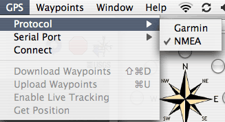
and then set your GPS to output data in NMEA format. Then in Terrabrowser, select the following menu options, as shown in Figure 5-5:
GPS->Protocol->NMEA,
GPS->Serial Port->usbserial0
GPS->Connect (figure 1)
GPS->Enable Live Tracking
Figure 5-5. The Terrabrowser GPS Connection menu
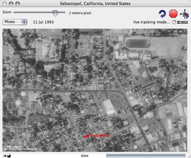
An aerial photo should pop up with your current location shown. If you happen to be visiting me in Sebastopol, California, it will look identical to Figure 5-6; otherwise, you will see a photo of your location.
Figure 5-6. Terrabrowser live tracking
The new version provides additional information on the GPS status, but live tracking is not yet bug-free.
5.8.2. Using Terrabrowser to View and Edit Waypoints
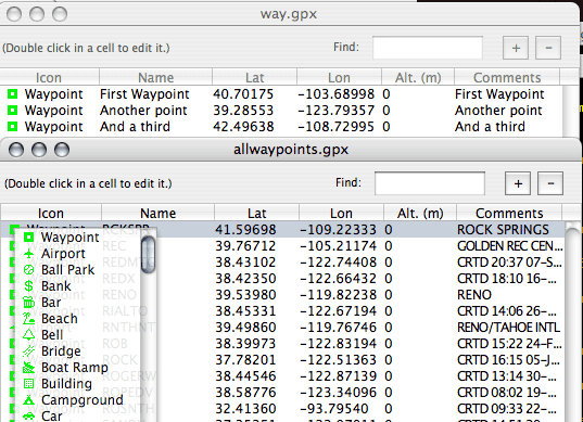
In addition to live position tracking, Terrabrowser implements a very nice multifile GPX waypoint editor and viewer, shown in Figure 5-7. You can open multiple GPX files, edit waypoints, and copy and paste between waypoint files with a nice tabular interface. The waypoint editor also allows you full access to all the waypoint features, including a nice drop-down of waypoint symbols.
Figure 5-7. Terrabrowser waypoint display and editing
Another great feature is the ability to search by ZIP Code. Select Navigate images/ent/U2192.GIF border=0> Find City (or press
 -F) and you can enter a ZIP Code. Terrabrowser then fetches the appropriate image, centered vaguely on that ZIP Code. This is an imprecise process for two reasons. First, Terraserver returns images in "tiles," so when you request the image for a lat/long, you get the tile that contains that point, but it is not centered. Also ZIP Codes are not points, so converting a ZIP Code to a single point is a tad imprecise.
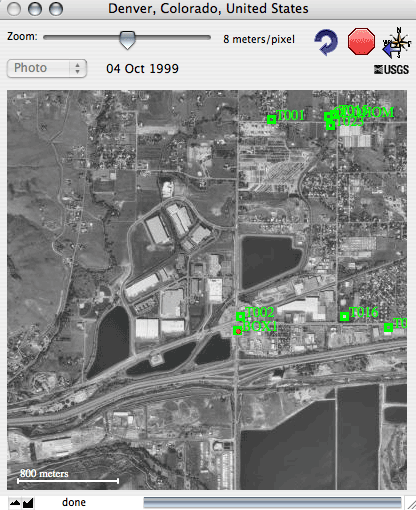
You can open a GPX-format waypoint file, and then select Waypointsimages/ent/U2192.GIF border=0>Center on Waypoint to fetch the Terraserver image, or USGS topo, for that point. In Figure 5-8, we centered on the waypoint "Box1."
Figure 5-8. Terrabrowser centered on waypoint "Box1"
Terrabrowser is shareware and well worth the $15 registration fee.
Mapping Your Life
- Hacks 1-13
- Hack 1. Put a Map on It: Mapping Arbitrary Locations with Online Services
- Hack 2. Route Planning Online
- Hack 3. Map the Places Youve Visited
- Hack 4. Find Your House on an Aerial Photograph
- Hack 5. The Road Less Traveled by in MapQuest
- Hack 6. Make Route Maps Easier to Read
- Hack 7. Will the Kids Barf?
- Hack 8. Publish Maps of Your Photos on the Web
- Hack 9. Track the Friendly Skies with Sherlock
- Hack 10. Georeference Digital Photos
- Hack 11. How Far? How Fast? Geo-Enabling Your Spreadsheet
- Hack 12. Create a Distance Grid in Excel
- Hack 13. Add Maps to Excel Spreadsheets with MapPoint
Mapping Your Neighborhood
- Hacks 14-21
- Hack 14. Make Free Maps of the United States Online
- Hack 15. Zoom Right In on Your Neighborhood
- Hack 16. Who Are the Neighbors Voting For?
- Hack 17. Map Nearby Wi-Fi Hotspots
- Hack 18. Why You Cant Watch Broadcast TV
- Hack 19. Analyze Elevation Profiles for Wireless Community Networks
- Hack 20. Make 3-D Raytraced Terrain Models
- Hack 21. Map Health Code Violations with RDFMapper
Mapping Your World
- Hacks 22-34
- Hack 22. Digging to China
- Hack 23. Explore David Rumseys Historical Maps
- Hack 24. Explore a 3-D Model of the Entire World
- Hack 25. Work with Multiple Lat/Long Formats
- Hack 26. Work with Different Coordinate Systems
- Hack 27. Calculate the Distance Between Points on the Earths Surface
- Hack 28. Experiment with Different Cartographic Projections
- Hack 29. Plot Arbitrary Points on a World Map
- Hack 30. Plot a Great Circle on a Flat Map
- Hack 31. Plot Dymaxion Maps in Perl
- Hack 32. Hack on Base Maps in Your Favorite Image Editor
- Hack 33. Georeference an Arbitrary Tourist Map
- Hack 34. Map Other Planets
Mapping (on) the Web
- Hacks 35-46
- Hack 35. Search Local, Find Global
- Hack 36. Shorten Online Map URLs
- Hack 37. Tweak the Look and Feel of Web Maps
- Hack 38. Add Location to Weblogs and RSS Feeds
- Hack 39. View Your Photo Thumbnails on a Flash Map
- Hack 40. Plot Points on a Spinning Globe Applet
- Hack 41. Plot Points on an Interactive Map Using DHTML
- Hack 42. Map Your Tracklogs on the Web
- Hack 43. Map Earthquakes in (Nearly) Real Time
- Hack 44. Plot Statistics Against Shapes
- Hack 45. Extract a Spatial Model from Wikipedia
- Hack 46. Map Global Weather Conditions
Mapping with Gadgets
- Hacks 47-63
- How GPS Works
- Hack 47. Get Maps on Your Mobile Phone
- Hack 48. Accessorize Your GPS
- Hack 49. Get Your Tracklogs in Windows or Linux
- Hack 50. The Serial Port to USB Conundrum
- Hack 51. Speak in Geotongues: GPSBabel to the Rescue
- Hack 52. Show Your Waypoints on Aerial Photos with Terrabrowser
- Hack 53. Visualize Your Tracks in Three Dimensions
- Hack 54. Create Your Own Maps for a Garmin GPS
- Hack 55. Use Your Track Memory as a GPS Base Map
- Hack 56. Animate Your Tracklogs
- Hack 57. Connect to Your GPS from Multiple Applications
- Hack 58. Dont Lose Your Tracklogs!
- Hack 59. Geocode Your Voice Recordings and Other Media
- Hack 60. Improve the Accuracy of Your GPS with Differential GPS
- Hack 61. Build a Map of Local GSM Cells
- Hack 62. Build a Car Computer
- Hack 63. Build Your Own Car Navigation System with GpsDrive
Mapping on Your Desktop
- Hacks 64-77
- Hack 64. Mapping Local Areas of Interest with Quantum GIS
- Hack 65. Extract Data from Maps with Manifold
- Hack 66. Java-Based Desktop Mapping with Openmap
- Hack 67. Seamless Data Download from the USGS
- Hack 68. Convert Geospatial Data Between Different Formats
- Hack 69. Find Your Way Around GRASS
- Hack 70. Import Your GPS Waypoints and Tracklogs into GRASS
- Hack 71. Turn Your Tracklogs into ESRI Shapefiles
- Hack 72. Add Relief to Your Topographic Maps
- Hack 73. Make Your Own Contour Maps
- Hack 74. Plot Wireless Network Viewsheds with GRASS
- Hack 75. Share Your GRASS Maps with the World
- Hack 76. Explore the Effects of Global Warming
- Conclusion
- Hack 77. Become a GRASS Ninja
Names and Places
- Hacks 78-86
- Hack 78. What to Do if Your Government Is Hoarding Geographic Data
- Hack 79. Geocode a U.S. Street Address
- Hack 80. Automatically Geocode U.S. Addresses
- Hack 81. Clean Up U.S. Addresses
- Hack 82. Find Nearby Things Using U.S. ZIP Codes
- Hack 83. Map Numerical Data the Easy Way
- Hack 84. Build a Free World Gazetteer
- Hack 85. Geocode U.S. Locations with the GNIS
- Hack 86. Track a Package Across the U.S.
Building the Geospatial Web
- Hacks 87-92
- Hack 87. Build a Spatially Indexed Data Store
- Hack 88. Load Your Waypoints into a Spatial Database
- Hack 89. Publish Your Geodata to the Web with GeoServer
- Hack 90. Crawl the Geospatial Web with RedSpider
- Hack 91. Build Interactive Web-Based Map Applications
- Hack 92. Map Wardriving (and other!) Data with MapServer
Mapping with Other People
- Hacks 93-100
- Hack 93. Node Runner
- Hack 94. Geo-Warchalking with 2-D Barcodes
- Hack 95. Model Interactive Spaces
- Hack 96. Share Geo-Photos on the Web
- Hack 97. Set Up an OpenGuide for Your Hometown
- Hack 98. Give Your Great-Great-Grandfather a GPS
- Hack 99. Map Your Friend-of-a-Friend Network
- Hack 100. Map Imaginary Places
EAN: 2147483647
Pages: 172
- Chapter I e-Search: A Conceptual Framework of Online Consumer Behavior
- Chapter II Information Search on the Internet: A Causal Model
- Chapter V Consumer Complaint Behavior in the Online Environment
- Chapter VII Objective and Perceived Complexity and Their Impacts on Internet Communication
- Chapter XVIII Web Systems Design, Litigation, and Online Consumer Behavior
