Hack 71. Turn Your Tracklogs into ESRI Shapefiles


Converting your GPS tracklogs into a standard vector format allows you to import them into any GIS or mapping application automatically.
Once you've gotten your GPS tracklogs into GRASS as site data [Hack #70], something you'll notice almost right away is that, when you zoom in close, your tracklog points appear as, well, individual points, and not as the tracks you might expect. The reason for this hardly needs explanation. Your GPS receiver's tracklog is really just a sample of your location over time, rather than a continuous stream. When you import that data into GRASS as point data, you are telling GRASS that you want to see it as a set of points, rather than as the connected arc that (approximately) describes your path through time and space. What's more, as site data in GRASS, it's relatively difficult to get that data back out and display it in a GIS browser, such as Quantum GIS or Mapserver.
One neat answer to this whole set of problems is ESRI's Shapefile format, an openly published vector data format that has become a sort of lingua franca for GIS vector data. Shapefiles offer a way of portably grouping and storing points, sets of points, arcs, and polygons. Frank Warmerdam's shapelib project offers a good, free C API for reading and writing shapefiles, so most GIS and mapping applications that speak vector data will speak ESRI's shapefile format. We'll hack up a quick fifty-line Perl script to turn your gpstrans tracklogs into shapefiles, so that they can be exported to other applications as line data, rather than as point data.
|

We'll use Geo::Shapelib, which is a thin layer of Perl wrapped around shapelib, to generate all three of these files from your tracklog.
You can get Geo::Shapelib from the CPAN using the following command as the superuser from a *NIX shell:
# perl -MCPAN -e 'install Geo::Shapelib'
In this script, which we'll call track2shp.pl, we'll also use the very handy Time::Piece module to parse the dates of the tracklog entries and do calculations with them. You can get Time::Piece from the CPAN.
Here's a sample bit of tracklog as output by gpstrans -dt:
Format: DDD UTC Offset: -8.00 hrs Datum[100]: WGS 84
T 02/07/2004 11:40:07 37.7396250 -122.4198818
T 02/07/2004 11:41:20 37.7395391 -122.4198604
T 02/07/2004 11:47:56 37.7394533 -122.4197745
T 02/07/2004 11:48:13 37.7394962 -122.4199033
T 02/07/2004 12:00:50 37.7393031 -122.4196029
T 02/07/2004 12:06:54 37.7394533 -122.4198604
As you can see, the gpstrans output format is very simple. There's a header line with some metadata, followed by several lines of data, each containing four tab-separated fields: the data type (i.e., T for tracklog), the timestamp, and a latitude/longitude pair. Obviously, the output from other GPS data download programs will look different, but the principle is the same. Extending the following code to work with the output of GARNIX and other programs is left as an exercise for the reader.
|
6.9.1. The Code
#!/usr/bin/perl

use Geo::Shapelib;
use Time::Piece;
use constant TIME_THRESHOLD => 10; # minutes
use constant TIME_FORMAT => "%m/%d/%Y %H:%M:%S";
use strict;
use warnings;

my ($in, $out) = @ARGV;
die "Usage: $0
" unless $in and $out;

my $shp = new Geo::Shapelib;
$shp->{Name} = $out;
$shp->{Shapetype} = 3; # PolyLine, according to Geo::Shapelib source
$shp->{FieldNames} = ['ID', 'Date'];
$shp->{FieldTypes} = ['Integer', 'String:16'];

open TRACK, "<", $in or die "Can't open $in: $!";

my $id = 0;
my (@vertices, $previous);

sub add_shape {
 return unless @vertices > 2;
 push @{$shp->{Shapes}}, {
 SHPType => 3, # PolyLine
 ShapeId => $id,
 NVertices => scalar @vertices,
 Vertices => [@vertices]
 };
 push @{$shp->{ShapeRecords}}, [$id++, $previous->ymd];
 @vertices = ( );
}

while ( ) {
 chomp;
 my ($type, $date, $lat, $long) = split /	/, $_, 4;
 my $now = eval { Time::Piece->strptime($date, TIME_FORMAT) };
 next unless $now;

 if (@vertices) {
 add_shape( ) if $now - $previous > TIME_THRESHOLD * 60;
 }

 push @vertices, [$long, $lat]; # note, long before lat!
 $previous = $now;
}

add_shape( );
$shp->save($out);
In its broadest outline, track2shp.pl reads each line from the given tracklog, splitting the line up into its component fields and throwing away the lines it can't parse. The script builds up a set of vertices from the tracklog points, storing them together as needed in a single PolyLine shape. (PolyLine is just ESRI's term for a series of connected line segments.) Finally, all of the accumulated PolyLines are dumped to the shapefile(s).
6.9.2. Running the Code
Assuming the script is marked as executable and is in your current directory, you can run it as follows:
$ gpstrans -dt > tracklog.txt
$ ./track2shp.pl tracklog.txt tracklog.shp
$ ls
track2shp.pl tracklog.dbf tracklog.shp tracklog.shx tracklog.txt
As you can see, you should have three new files in the same directory: the .shp file containing the shapes, the .shx index file, and the .dbf datafile.
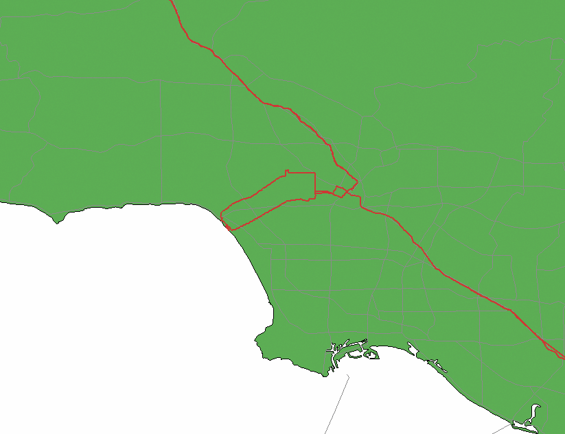
Figure 6-31 shows a sample map of a trip we made through Los Angeles, stopping off in Hollywood to pick up friends and then visiting Venice Beach, before dropping our friends off and continuing north on Interstate 5. This map was made with about five minutes of work in Quantum GIS, using the U.S. state borders and major roads layers from http://nationalatlas.gov and, of course, a GPS track processed with gpstrans and track2shp.pl.
Figure 6-31. A Shapefile made from a trip through Los Angeles
6.9.3. Understanding the Code
We have glossed over some of the details of this script. For example, what's this TIME_THRESHOLD business? Well, at first blush, we might consider it easiest to simply whack the whole tracklog together into a single PolyLine and call it done. The problem with this is that GPS reception frequently suffers dropouts of varying kinds, leading to missing data points. Sometimes dropouts are momentary, perhaps the result of your receiver simply losing its satellite lock for a minute or two as you drove past an inopportunely placed hill or building. In this case, we can probably just draw a straight line between the two known-good points on either side, and call it close enough.
But what if you lose reception for more than a few minutes, as can easily happen in urban areas? What if you shut your GPS receiver off and don't turn it back on until many days or many kilometers later? In these circumstances, it would be downright inaccurate and even misleading to simply interpolate a straight line between the two otherwise correct points on either side. This is where the TIME_THRESHOLD value comes in: track2shp.pl keeps track of how much time has elapsed between successive log entries. If the elapsed time is more than 10 minutes, then track2shp.pl assumes that a dropout (accidental or otherwise) has occurred and treats it as a signal to start a new PolyLine. In this fashion, we can tweak the TIME_THRESHOLD setting to group tracklogs of different trips together in a single shapefile, while treating them as individual features for the sake of mapping or GIS use.
There are a few other things worth mentioning about this script. First, note the TIME_FORMAT constant defined at the top. This string is passed to Time::Piece to tell it how to parse the timestamp in each tracklog entry. If you need to alter it for any reason, refer to the manual page for strptime(3) on your system for the syntax. One could make this "Do What I Mean" in more and different circumstances by replacing Time::Piece with Date::Parse from the CPAN, which would be more flexible but far less efficient.
Finally, note the use of the $shp->{ShapeRecords} array, which allows us to associate other data values with each feature in the shapefile. The data fields are defined by $shp->{FieldNames} and $shp->{FieldTypes}, about which you can read more in perldoc Geo::Shapelib. The important thing is that Geo::Shapelib stores the values from $shp->{ShapeRecords} in the resulting .dbf file, which you can read with most modern spreadsheet programs, such as Gnumeric or Excel. Load the .dbf file produced by track2shp.pl in one of these programs, and you should see two columns. The first is an arbitrary numeric identifier for each feature that track2shp.pl found in the tracklog, and the second is the date on which that feature was finally recorded, which is returned from the call to $previous->ymd. Obviously, with a little experimentation, you can add more fields and put all kinds of other stuff in here, such as the start and stop times of each individual track, the time elapsed, distance traveled, average speed, and more.
You can now import and visualize your tracklog in a plethora of mapping and GIS applications, including GRASS, Quantum GIS, Thuban, Mapserver, Manifold, and even ArcView.
6.9.4. Hacking the Hack
There is one other weak point remaining in this hack, which is the possibility of spurious data in the GPS tracklog. In one real-life example, a drive from San Francisco to Oakland on the lower deck of the Bay Bridge caused the GPS reception to cut out completely, with the exception of a single reading placed off the coast of Baja California. If we treat this point as valid, then it appears as if the automobile suddenly teleported from one end of the bridge out to the Tropic of Cancer over the Pacific Ocean and then back to the other end of the bridge, all in a matter of minutes! This effect is shown in Figure 6-32 by the two red lines shooting off to the south of the map.
Figure 6-32. A sudden, unexplained jaunt to Baja California
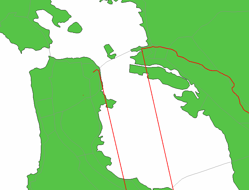
Presumably, the GPS signals bouncing around inside the steel infrastructure of the bridge resulted in an accumulation of multipath error in the receiver, causing the sudden and obviously false data point. How can we detect and eliminate these errors from our shapefiles? One way might be to calculate the mean velocity between successive tracklog points. If the calculated velocity is in excess of any speed a human being is likely to be traveling near the surface of the earthsay, the 800 km/h cruising speed of your average jet airlinerthen we can safely assume that the next data point is spurious and ought to be ignored.
In order to calculate velocity, we need measures of time, which are already in the tracklog, and distance, which for reasons described in [Hack #27] can be a bit tricky for short hops. For the sake of expediencythis is a hack, after allwe will rely on Geo::Distance, which will suffice insofar as we are not after exact distances so much as a rule of thumb with which to judge the validity of our collected position data. Geo::Distance can be obtained from the CPAN.
First, make the following additions near the top of track2shp.pl:
use Geo::Shapelib;
use Geo::Distance ':all'
use Time::Piece;
use constant SPEED_THRESHOLD => 1000; # km/h
use constant TIME_THRESHOLD => 10; # minutes
use constant TIME_FORMAT => "%m/%d/%Y %H:%M:%S";
use strict;
Next, in the main loop, add the distance calculation:
 if (@vertices) {
 my $d = distance_calc( kilometer => $vertices[-1], [$long, $lat] );
 next if $d / ($now - $previous) > SPEED_THRESHOLD / 3600;
 add_shape( ) if $now - $previous > TIME_THRESHOLD * 60;
 }
For the call to distance_calc(), we pass the units we want back, the previous point in the vertex list, and the current point we want to test. If the result divided by the time difference is greater than our threshold speed (scaled here to km/s for calculation purposes), then the next data point is assumed to be spurious and is skipped. With four extra lines of code, we have extended track2shp.pl to filter out bad data caused by intermittent GPS reception. Figure 6-33 shows the resulting shapefile.
Figure 6-33. The same shapefile, corrected
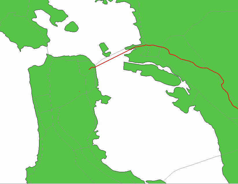
Although the line interpolated across the Bay in place of actual data doesn't quite overlap perfectly with the vector feature matching the bridge, it certainly comes a lot closer than our previous version did!
This filtering method has other potential drawbacks. Should the first data point collected be spurious and the rest valid, the script will make the mistake of assuming the subsequent points are wrong. Also, as mentioned earlier, the results returned from Geo::Distance might be inaccurate for very small distances, which could conceivably trigger false positives in exceptional circumstances. Meanwhile, track2shp.pl is starting to accumulate a few configurable settings that good software design dictates should be turned into command-line options, rather than source code constants. Of course, if we solved all of these remaining issues, we might find ourselves with something a lot closer to a software product than a simple hack!
Mapping Your Life
- Hacks 1-13
- Hack 1. Put a Map on It: Mapping Arbitrary Locations with Online Services
- Hack 2. Route Planning Online
- Hack 3. Map the Places Youve Visited
- Hack 4. Find Your House on an Aerial Photograph
- Hack 5. The Road Less Traveled by in MapQuest
- Hack 6. Make Route Maps Easier to Read
- Hack 7. Will the Kids Barf?
- Hack 8. Publish Maps of Your Photos on the Web
- Hack 9. Track the Friendly Skies with Sherlock
- Hack 10. Georeference Digital Photos
- Hack 11. How Far? How Fast? Geo-Enabling Your Spreadsheet
- Hack 12. Create a Distance Grid in Excel
- Hack 13. Add Maps to Excel Spreadsheets with MapPoint
Mapping Your Neighborhood
- Hacks 14-21
- Hack 14. Make Free Maps of the United States Online
- Hack 15. Zoom Right In on Your Neighborhood
- Hack 16. Who Are the Neighbors Voting For?
- Hack 17. Map Nearby Wi-Fi Hotspots
- Hack 18. Why You Cant Watch Broadcast TV
- Hack 19. Analyze Elevation Profiles for Wireless Community Networks
- Hack 20. Make 3-D Raytraced Terrain Models
- Hack 21. Map Health Code Violations with RDFMapper
Mapping Your World
- Hacks 22-34
- Hack 22. Digging to China
- Hack 23. Explore David Rumseys Historical Maps
- Hack 24. Explore a 3-D Model of the Entire World
- Hack 25. Work with Multiple Lat/Long Formats
- Hack 26. Work with Different Coordinate Systems
- Hack 27. Calculate the Distance Between Points on the Earths Surface
- Hack 28. Experiment with Different Cartographic Projections
- Hack 29. Plot Arbitrary Points on a World Map
- Hack 30. Plot a Great Circle on a Flat Map
- Hack 31. Plot Dymaxion Maps in Perl
- Hack 32. Hack on Base Maps in Your Favorite Image Editor
- Hack 33. Georeference an Arbitrary Tourist Map
- Hack 34. Map Other Planets
Mapping (on) the Web
- Hacks 35-46
- Hack 35. Search Local, Find Global
- Hack 36. Shorten Online Map URLs
- Hack 37. Tweak the Look and Feel of Web Maps
- Hack 38. Add Location to Weblogs and RSS Feeds
- Hack 39. View Your Photo Thumbnails on a Flash Map
- Hack 40. Plot Points on a Spinning Globe Applet
- Hack 41. Plot Points on an Interactive Map Using DHTML
- Hack 42. Map Your Tracklogs on the Web
- Hack 43. Map Earthquakes in (Nearly) Real Time
- Hack 44. Plot Statistics Against Shapes
- Hack 45. Extract a Spatial Model from Wikipedia
- Hack 46. Map Global Weather Conditions
Mapping with Gadgets
- Hacks 47-63
- How GPS Works
- Hack 47. Get Maps on Your Mobile Phone
- Hack 48. Accessorize Your GPS
- Hack 49. Get Your Tracklogs in Windows or Linux
- Hack 50. The Serial Port to USB Conundrum
- Hack 51. Speak in Geotongues: GPSBabel to the Rescue
- Hack 52. Show Your Waypoints on Aerial Photos with Terrabrowser
- Hack 53. Visualize Your Tracks in Three Dimensions
- Hack 54. Create Your Own Maps for a Garmin GPS
- Hack 55. Use Your Track Memory as a GPS Base Map
- Hack 56. Animate Your Tracklogs
- Hack 57. Connect to Your GPS from Multiple Applications
- Hack 58. Dont Lose Your Tracklogs!
- Hack 59. Geocode Your Voice Recordings and Other Media
- Hack 60. Improve the Accuracy of Your GPS with Differential GPS
- Hack 61. Build a Map of Local GSM Cells
- Hack 62. Build a Car Computer
- Hack 63. Build Your Own Car Navigation System with GpsDrive
Mapping on Your Desktop
- Hacks 64-77
- Hack 64. Mapping Local Areas of Interest with Quantum GIS
- Hack 65. Extract Data from Maps with Manifold
- Hack 66. Java-Based Desktop Mapping with Openmap
- Hack 67. Seamless Data Download from the USGS
- Hack 68. Convert Geospatial Data Between Different Formats
- Hack 69. Find Your Way Around GRASS
- Hack 70. Import Your GPS Waypoints and Tracklogs into GRASS
- Hack 71. Turn Your Tracklogs into ESRI Shapefiles
- Hack 72. Add Relief to Your Topographic Maps
- Hack 73. Make Your Own Contour Maps
- Hack 74. Plot Wireless Network Viewsheds with GRASS
- Hack 75. Share Your GRASS Maps with the World
- Hack 76. Explore the Effects of Global Warming
- Conclusion
- Hack 77. Become a GRASS Ninja
Names and Places
- Hacks 78-86
- Hack 78. What to Do if Your Government Is Hoarding Geographic Data
- Hack 79. Geocode a U.S. Street Address
- Hack 80. Automatically Geocode U.S. Addresses
- Hack 81. Clean Up U.S. Addresses
- Hack 82. Find Nearby Things Using U.S. ZIP Codes
- Hack 83. Map Numerical Data the Easy Way
- Hack 84. Build a Free World Gazetteer
- Hack 85. Geocode U.S. Locations with the GNIS
- Hack 86. Track a Package Across the U.S.
Building the Geospatial Web
- Hacks 87-92
- Hack 87. Build a Spatially Indexed Data Store
- Hack 88. Load Your Waypoints into a Spatial Database
- Hack 89. Publish Your Geodata to the Web with GeoServer
- Hack 90. Crawl the Geospatial Web with RedSpider
- Hack 91. Build Interactive Web-Based Map Applications
- Hack 92. Map Wardriving (and other!) Data with MapServer
Mapping with Other People
- Hacks 93-100
- Hack 93. Node Runner
- Hack 94. Geo-Warchalking with 2-D Barcodes
- Hack 95. Model Interactive Spaces
- Hack 96. Share Geo-Photos on the Web
- Hack 97. Set Up an OpenGuide for Your Hometown
- Hack 98. Give Your Great-Great-Grandfather a GPS
- Hack 99. Map Your Friend-of-a-Friend Network
- Hack 100. Map Imaginary Places
EAN: 2147483647
Pages: 172
