Hack 43. Map Earthquakes in (Nearly) Real Time


With an RSS feed and a bit of Flash, you can map earthquakes around the world, as they happen.
Originally, this hack was going to cover some pretty straightforward HTML screen scraping from the USGS Earthquake web site, but, lucky for us, times have changed. The happiest end for any screen-scraping application is when the screen scraper is no longer needed because the scrapee has made the data available in a machine-readable format. Yesss! In just such a case, the USGS has recently started publishing earthquake alerts in RSS 2.0, which makes mapping recent earthquakes in worldKit a snap.
The USGS's recent earthquake RSS feeds are listed at http://earthquake.usgs.gov/recenteqsww/rss.html, along with directions on how to subscribe to them with several popular RSS newsreaders. Several feeds are available, arranged by magnitude and age. For mapping applications, these RSS files make use of a couple RSS namespaces to include metadata on each quake. The latitude and longitude of each quake epicenter is included via the ICBM namespace (http://postneo.com/icbm/), and the integer value of the Richter Scale magnitude is included in the Dublin Core dc:subject element (http://dublincore.org/).
Here's an example of the format of an RSS item about an earthquake.
Loma Prieta Earthquake October 17, 1989 5:04 pmhttp://wrgis.wr.usgs.gov/dds/dds-29/
 37.04
 -121.88
 7
Mapping an RSS feed like this is easy with worldKit [Hack #39] . You can find the download, documentation, and examples at http://brainoff.com/worldkit/.
After worldKit is downloaded and installed, the next step is to configure the data feed and images in config.xml. The data feed is specified in the dataurl element, as one of two choices: you can either point the data feed directly to the USGS feed of your choice, or the RSS feed can be periodically downloaded to your server. The difference is primarily in their respective disadvantages. The first option will generate a security warning in the Flash plug-in, since, by default, the player can only make connections to the site where the SWF file is hosted. Keeping a local copy of the feed requires setting up a small cron job to download the file to your server. The entry in your crontab would look something like:
17 * * * * wget -O $HOME/public_html/quakemap/quake.rss http://earthquake.usgs.gov/
recenteqsww/eqs1day-M2.5.xml
The above command should be on one line in your crontab file. You would then point the dataurl element of config.xml at the file on your web server. The other downside of this, of course, is that your local copy of the feed will only be up to date once an hour (or however frequently you set the cron job to run).
As for imagery, the Blue Marble image packaged with worldKit will work just fine out of the box. If you're feeling inspired, you can find other Earth imagery at NASA's Earth Observatory site located at http://earthobservatory.nasa.gov/, and decent world topographic maps can be found at http://flatplanet.sourceforge.net/maps/topo.html. For that matter, any cylindrical-projection (e.g., Mercator) world map will suffice. Save the image on your server, and point worldKit to it in your config.xml file with the dayimg element; you should see something like Figure 4-14.
Figure 4-14. An excerpt from a worldKit earthquake map, showing the Western Hemisphere
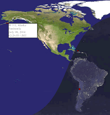
Given that the USGS includes the magnitude of each quake in the dc:subject element, you can also configure worldKit to plot the location of each quake with a different size marker relative to its rating on the Richter Scale. Figure 4-14 shows part of a worldKit map made this way. All that's needed is an additional plotsize element in config.xml, which accepts subtags with names corresponding to dc:subject values. The values of the subtags establish the corresponding marker sizes. For earthquake feeds, you can expect Richter magnitudes ranging from 1 to 10, so that's what we'll feed into worldKit:
6
 <1>2<2>4<3>6<4>8<5>10
 <6>12<7>14<8>16<9>18<10>20
The default plotsize is given by the first value (in this case, 6), to be used when an item's dc:subject is missing or otherwise unusable.
|

4.10.1. Hacking the Hack
What if you're primarily interested in quakes in your immediate neighborhood? In that case, you can specify a bounding box for your map in terms of latitude and longitude in your config.xml file. Here's an example that covers the San Francisco Bay Area:
38.20
37.30
-121.87
-123.00
If a bounding box is specified, worldKit will only display items in the feed within the bounding box. You only need to provide an image that corresponds to your location. If you don't have a map of your area handy, we can offer a couple of suggestions on how to obtain one easily.
First, you might try MapProxy (http://brainoff.com/worldkit/mapproxy/), a simple web interface to TerraServer, which can fetch U.S. topo maps or aerial photos, given a ZIP Code and distance. MapProxy generates the corresponding worldKit bounding box configuration for you, as well.
Failing that, you can take one of the world maps, and extract the area corresponding to your bounding box with Photoshop or ImageMagick. To convert the bounding box in latitude and longitude to x- and y-coordinates in the image, use the following formulas from Table 4-1.
|
Side |
Conversion formula |
|---|---|
|
Top |
(90 - north) * height / 180 |
|
Bottom |
(90 - south) * height / 180 |
|
Left |
(180 + west) * width / 360 |
|
Right |
(180 + east) * width / 360 |
Mikel Maron
Mapping Your Life
- Hacks 1-13
- Hack 1. Put a Map on It: Mapping Arbitrary Locations with Online Services
- Hack 2. Route Planning Online
- Hack 3. Map the Places Youve Visited
- Hack 4. Find Your House on an Aerial Photograph
- Hack 5. The Road Less Traveled by in MapQuest
- Hack 6. Make Route Maps Easier to Read
- Hack 7. Will the Kids Barf?
- Hack 8. Publish Maps of Your Photos on the Web
- Hack 9. Track the Friendly Skies with Sherlock
- Hack 10. Georeference Digital Photos
- Hack 11. How Far? How Fast? Geo-Enabling Your Spreadsheet
- Hack 12. Create a Distance Grid in Excel
- Hack 13. Add Maps to Excel Spreadsheets with MapPoint
Mapping Your Neighborhood
- Hacks 14-21
- Hack 14. Make Free Maps of the United States Online
- Hack 15. Zoom Right In on Your Neighborhood
- Hack 16. Who Are the Neighbors Voting For?
- Hack 17. Map Nearby Wi-Fi Hotspots
- Hack 18. Why You Cant Watch Broadcast TV
- Hack 19. Analyze Elevation Profiles for Wireless Community Networks
- Hack 20. Make 3-D Raytraced Terrain Models
- Hack 21. Map Health Code Violations with RDFMapper
Mapping Your World
- Hacks 22-34
- Hack 22. Digging to China
- Hack 23. Explore David Rumseys Historical Maps
- Hack 24. Explore a 3-D Model of the Entire World
- Hack 25. Work with Multiple Lat/Long Formats
- Hack 26. Work with Different Coordinate Systems
- Hack 27. Calculate the Distance Between Points on the Earths Surface
- Hack 28. Experiment with Different Cartographic Projections
- Hack 29. Plot Arbitrary Points on a World Map
- Hack 30. Plot a Great Circle on a Flat Map
- Hack 31. Plot Dymaxion Maps in Perl
- Hack 32. Hack on Base Maps in Your Favorite Image Editor
- Hack 33. Georeference an Arbitrary Tourist Map
- Hack 34. Map Other Planets
Mapping (on) the Web
- Hacks 35-46
- Hack 35. Search Local, Find Global
- Hack 36. Shorten Online Map URLs
- Hack 37. Tweak the Look and Feel of Web Maps
- Hack 38. Add Location to Weblogs and RSS Feeds
- Hack 39. View Your Photo Thumbnails on a Flash Map
- Hack 40. Plot Points on a Spinning Globe Applet
- Hack 41. Plot Points on an Interactive Map Using DHTML
- Hack 42. Map Your Tracklogs on the Web
- Hack 43. Map Earthquakes in (Nearly) Real Time
- Hack 44. Plot Statistics Against Shapes
- Hack 45. Extract a Spatial Model from Wikipedia
- Hack 46. Map Global Weather Conditions
Mapping with Gadgets
- Hacks 47-63
- How GPS Works
- Hack 47. Get Maps on Your Mobile Phone
- Hack 48. Accessorize Your GPS
- Hack 49. Get Your Tracklogs in Windows or Linux
- Hack 50. The Serial Port to USB Conundrum
- Hack 51. Speak in Geotongues: GPSBabel to the Rescue
- Hack 52. Show Your Waypoints on Aerial Photos with Terrabrowser
- Hack 53. Visualize Your Tracks in Three Dimensions
- Hack 54. Create Your Own Maps for a Garmin GPS
- Hack 55. Use Your Track Memory as a GPS Base Map
- Hack 56. Animate Your Tracklogs
- Hack 57. Connect to Your GPS from Multiple Applications
- Hack 58. Dont Lose Your Tracklogs!
- Hack 59. Geocode Your Voice Recordings and Other Media
- Hack 60. Improve the Accuracy of Your GPS with Differential GPS
- Hack 61. Build a Map of Local GSM Cells
- Hack 62. Build a Car Computer
- Hack 63. Build Your Own Car Navigation System with GpsDrive
Mapping on Your Desktop
- Hacks 64-77
- Hack 64. Mapping Local Areas of Interest with Quantum GIS
- Hack 65. Extract Data from Maps with Manifold
- Hack 66. Java-Based Desktop Mapping with Openmap
- Hack 67. Seamless Data Download from the USGS
- Hack 68. Convert Geospatial Data Between Different Formats
- Hack 69. Find Your Way Around GRASS
- Hack 70. Import Your GPS Waypoints and Tracklogs into GRASS
- Hack 71. Turn Your Tracklogs into ESRI Shapefiles
- Hack 72. Add Relief to Your Topographic Maps
- Hack 73. Make Your Own Contour Maps
- Hack 74. Plot Wireless Network Viewsheds with GRASS
- Hack 75. Share Your GRASS Maps with the World
- Hack 76. Explore the Effects of Global Warming
- Conclusion
- Hack 77. Become a GRASS Ninja
Names and Places
- Hacks 78-86
- Hack 78. What to Do if Your Government Is Hoarding Geographic Data
- Hack 79. Geocode a U.S. Street Address
- Hack 80. Automatically Geocode U.S. Addresses
- Hack 81. Clean Up U.S. Addresses
- Hack 82. Find Nearby Things Using U.S. ZIP Codes
- Hack 83. Map Numerical Data the Easy Way
- Hack 84. Build a Free World Gazetteer
- Hack 85. Geocode U.S. Locations with the GNIS
- Hack 86. Track a Package Across the U.S.
Building the Geospatial Web
- Hacks 87-92
- Hack 87. Build a Spatially Indexed Data Store
- Hack 88. Load Your Waypoints into a Spatial Database
- Hack 89. Publish Your Geodata to the Web with GeoServer
- Hack 90. Crawl the Geospatial Web with RedSpider
- Hack 91. Build Interactive Web-Based Map Applications
- Hack 92. Map Wardriving (and other!) Data with MapServer
Mapping with Other People
- Hacks 93-100
- Hack 93. Node Runner
- Hack 94. Geo-Warchalking with 2-D Barcodes
- Hack 95. Model Interactive Spaces
- Hack 96. Share Geo-Photos on the Web
- Hack 97. Set Up an OpenGuide for Your Hometown
- Hack 98. Give Your Great-Great-Grandfather a GPS
- Hack 99. Map Your Friend-of-a-Friend Network
- Hack 100. Map Imaginary Places
EAN: 2147483647
Pages: 172
