Hack 21. Map Health Code Violations with RDFMapper


With this simple web service, you can build interactive Flash maps from arbitrary data sources in RSS or RDF.
RDFMapper is a web service that searches an RDF file for resources with geographic locations and returns a map overlaid with dots representing the located resources. Clicking on a dot displays information about the clicked resource. Arbitrary images can be treated as maps, so the service can be used for any kind of image annotation.
One big advantage of using RDF for spatial annotation is that it allows data of different types to be mingled freely. RDF is built from a series of "vocabularies": for example, there are vocabularies for weblog posts (RSS), for personal descriptions (FOAF), for restaurants (ChefMoz), for time and events (RDFCalendar), for geometry (RDFGeom2d), and for geography (RDFIG Geo). These vocabularies can be mixed together in the same RDF documents. Any kind of RDF content can be annotated with geographical location, simply by dropping in latitude and longitude properties from the simple Geo vocabulary at http://www.w3.org/2003/01/geo/wgs84_pos#, which describes latitude and longitude in WGS84. Then, RDFMapper can be used to make instant maps of the content. The RDF approach integrates geodata into any domain where it is relevant, without requiring any changes to schemas or data models.
There are innumerable sources of RDF on the Web. Among them are weblogs whose "feeds" are in RSS 1.0 (the RDF dialect of RSS), and descriptions of people and their relationships encoded using the FOAF ("friend of a friend") namespace. Many other sources exist. (For example, the contents of the DMOZ open directory, http://dmoz.org/, are available in RDF.)
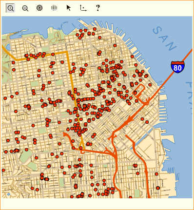
But it's easy to roll your own, as Dav Coleman chose to do when making maps of health code violations in San Francisco. On its web site, the city publishes lists of all food service providers, along with enticing details of the violations they've committed: Unsafe Food Source, Vermin, Personal Hygiene, and so on. He used a few Perl scripts to scrape the site, extract the health code details and the street addresses of the restaurants, and locate them using a geocoding service such as http://geocoder.us/ (see [Hack #79] for details on how to do this easily yourself). He published the results as an RDF file (available at http://mappinghacks.com/data/sfhealth.rdf), giving the name and location of each restaurant for which a health code violation had been reported.
The following HTML invokes RDFMapper to map the contents of this RDF file. It sends a set of key-value pairs to the web service, which returns a map in .swf (Macromedia Flash) format:
<a href="javascript:document.forms[form1].submit( );">Submit</a>
When this invisible form is submitted by clicking on the "Submit" link, it performs an HTTP POST to the RDFMapper web service. RDFMapper puts together a map and sends it back to the client.
Figure 2-22 shows the RDFMapper visualization of the RDF file of health code violations. You can view information about individual restaurants by clicking on the appropriate dot on the map. This could be a "how to lie with maps" story: the only level of metadata visually displayed is that there is a violation of some kind there; this could be one relatively innocuous citation for "Holding Temperatures" a degree or two too warm, or a string of violations including Vermin and Contaminated Equipment. On this map, they all look the same qualitatively. However, this is hopefully a good illustration of using RDF as an intermediary format. RDFMapper can also be used to map web data that is not already presented in RDF, with the help of quick conversion scripts.
Figure 2-22. The RDFMapper map of San Francisco health code violations
2.9.1. The RDFMapper Web Service in Depth
The basemap parameter passed to the RDFMapper service specifies the URL of a file in RDFMap format describing the map that is to appear in the background. This RDFMap file specifies the URL of the image and the parameters of the geographic projection that applies to the image. The image is either a JPEG or a .swf file. A catalog of maps suitable for use with RDFMapper can be found at http://www.mapbureau.com/viewer. You can also create your own base maps from existing images by encoding the relevant projection data in RDFMap format.
The content parameter specifies the URL of the RDF file to be mapped.
Most of the remaining parameters denote functions defined in the Fabl programming language, an open source language designed specifically for manipulating RDF. (Fabl is implemented within RDF as well; see http://fabl.net for more details.) Parameters naming Fabl functions may take the form:
or
#
In the former case, the function is taken from a library of utility functions for RDFMapper, available at http://www.mapbureau.com/libsrc/rdfmapper_utils-2.0.fbl. In the latter case, the function is taken from the specified Fabl code file. See the rdfmapper_utils-2.0.fbl file for documentation of the utilities used in the previous example, such as itemGen1, extractTopicLocation, and so on. If, as is often the case, the functions appearing in the library suit the purposes of an application, there is no need to develop new versions.
The extractor parameter denotes a Fabl function that, when given an RDF resource, returns a geom2d:Point representing its location, or nil. RDFMapper maps everything (that is, all resources) in the content file for which extractor returns a non-nil value. Here's a sample extractor:
geom2d:Point function extractGeoLatLong(Resource x) {
 var geom2d:Point rs;
 if ((count(x,geo:lat)>0) && (count(x,geo:long)>0))
 {
 rs = new(geom2d:Point);
 rs . geom2d:x = x.geo:long;
 rs . geom2d:y = x.geo:lat;
 return rs;
 }
 return nil ~ geom2d:Point;
}
In English, this code reads: "If geo:lat and geo:long each take on at least one value within some resource x, then extract the corresponding values, package them as a geom2d:Point, and return that Point."
Additional details about RDFMapper, including a complete description of all parameters, can be found at http://www.mapbureau.com/rdfmapper/2.0.
2.9.2. Hacking RDFMapper
Although RDFMapper is designed to plot locations from geo-annotated RSS and RDF, there are workarounds in case your hosted online journal service, such as Blogger, doesn't have the facility to let you add new tags and namespaces to your RSS feed.
RDFMapper's extractLocation function gets around this issue by scanning the content of posts for text of the form 124.12346.16. Such text can be hidden from the reader of the weblog by embedding it in a span of the form:
124.12346.16
It's not pretty, but it works! The following RDFMapper parameters will map a Blogger weblog:
name="basemap" value="http://www.mapbureau.com/basemaps/astoria.0.xml"
name="content" value="http://rdfmapperexample.blogspot.com/rss/
rdfmapperexample.xml"
name="extractor" value="extractLocation"
name="itemGen" value="itemGen0"
Using this hack, any weblog with an RSS feed can be mapped with RDFMapper. In fact, RDFMapper is a generalization of an earlier service called Blogmapper, which mapped weblogs but not other varieties of RDF. If you just want to map blog posts, then you might have a look at Blogmapper itself, at http://blogmapper.com/.
Chris Goad
Mapping Your Life
- Hacks 1-13
- Hack 1. Put a Map on It: Mapping Arbitrary Locations with Online Services
- Hack 2. Route Planning Online
- Hack 3. Map the Places Youve Visited
- Hack 4. Find Your House on an Aerial Photograph
- Hack 5. The Road Less Traveled by in MapQuest
- Hack 6. Make Route Maps Easier to Read
- Hack 7. Will the Kids Barf?
- Hack 8. Publish Maps of Your Photos on the Web
- Hack 9. Track the Friendly Skies with Sherlock
- Hack 10. Georeference Digital Photos
- Hack 11. How Far? How Fast? Geo-Enabling Your Spreadsheet
- Hack 12. Create a Distance Grid in Excel
- Hack 13. Add Maps to Excel Spreadsheets with MapPoint
Mapping Your Neighborhood
- Hacks 14-21
- Hack 14. Make Free Maps of the United States Online
- Hack 15. Zoom Right In on Your Neighborhood
- Hack 16. Who Are the Neighbors Voting For?
- Hack 17. Map Nearby Wi-Fi Hotspots
- Hack 18. Why You Cant Watch Broadcast TV
- Hack 19. Analyze Elevation Profiles for Wireless Community Networks
- Hack 20. Make 3-D Raytraced Terrain Models
- Hack 21. Map Health Code Violations with RDFMapper
Mapping Your World
- Hacks 22-34
- Hack 22. Digging to China
- Hack 23. Explore David Rumseys Historical Maps
- Hack 24. Explore a 3-D Model of the Entire World
- Hack 25. Work with Multiple Lat/Long Formats
- Hack 26. Work with Different Coordinate Systems
- Hack 27. Calculate the Distance Between Points on the Earths Surface
- Hack 28. Experiment with Different Cartographic Projections
- Hack 29. Plot Arbitrary Points on a World Map
- Hack 30. Plot a Great Circle on a Flat Map
- Hack 31. Plot Dymaxion Maps in Perl
- Hack 32. Hack on Base Maps in Your Favorite Image Editor
- Hack 33. Georeference an Arbitrary Tourist Map
- Hack 34. Map Other Planets
Mapping (on) the Web
- Hacks 35-46
- Hack 35. Search Local, Find Global
- Hack 36. Shorten Online Map URLs
- Hack 37. Tweak the Look and Feel of Web Maps
- Hack 38. Add Location to Weblogs and RSS Feeds
- Hack 39. View Your Photo Thumbnails on a Flash Map
- Hack 40. Plot Points on a Spinning Globe Applet
- Hack 41. Plot Points on an Interactive Map Using DHTML
- Hack 42. Map Your Tracklogs on the Web
- Hack 43. Map Earthquakes in (Nearly) Real Time
- Hack 44. Plot Statistics Against Shapes
- Hack 45. Extract a Spatial Model from Wikipedia
- Hack 46. Map Global Weather Conditions
Mapping with Gadgets
- Hacks 47-63
- How GPS Works
- Hack 47. Get Maps on Your Mobile Phone
- Hack 48. Accessorize Your GPS
- Hack 49. Get Your Tracklogs in Windows or Linux
- Hack 50. The Serial Port to USB Conundrum
- Hack 51. Speak in Geotongues: GPSBabel to the Rescue
- Hack 52. Show Your Waypoints on Aerial Photos with Terrabrowser
- Hack 53. Visualize Your Tracks in Three Dimensions
- Hack 54. Create Your Own Maps for a Garmin GPS
- Hack 55. Use Your Track Memory as a GPS Base Map
- Hack 56. Animate Your Tracklogs
- Hack 57. Connect to Your GPS from Multiple Applications
- Hack 58. Dont Lose Your Tracklogs!
- Hack 59. Geocode Your Voice Recordings and Other Media
- Hack 60. Improve the Accuracy of Your GPS with Differential GPS
- Hack 61. Build a Map of Local GSM Cells
- Hack 62. Build a Car Computer
- Hack 63. Build Your Own Car Navigation System with GpsDrive
Mapping on Your Desktop
- Hacks 64-77
- Hack 64. Mapping Local Areas of Interest with Quantum GIS
- Hack 65. Extract Data from Maps with Manifold
- Hack 66. Java-Based Desktop Mapping with Openmap
- Hack 67. Seamless Data Download from the USGS
- Hack 68. Convert Geospatial Data Between Different Formats
- Hack 69. Find Your Way Around GRASS
- Hack 70. Import Your GPS Waypoints and Tracklogs into GRASS
- Hack 71. Turn Your Tracklogs into ESRI Shapefiles
- Hack 72. Add Relief to Your Topographic Maps
- Hack 73. Make Your Own Contour Maps
- Hack 74. Plot Wireless Network Viewsheds with GRASS
- Hack 75. Share Your GRASS Maps with the World
- Hack 76. Explore the Effects of Global Warming
- Conclusion
- Hack 77. Become a GRASS Ninja
Names and Places
- Hacks 78-86
- Hack 78. What to Do if Your Government Is Hoarding Geographic Data
- Hack 79. Geocode a U.S. Street Address
- Hack 80. Automatically Geocode U.S. Addresses
- Hack 81. Clean Up U.S. Addresses
- Hack 82. Find Nearby Things Using U.S. ZIP Codes
- Hack 83. Map Numerical Data the Easy Way
- Hack 84. Build a Free World Gazetteer
- Hack 85. Geocode U.S. Locations with the GNIS
- Hack 86. Track a Package Across the U.S.
Building the Geospatial Web
- Hacks 87-92
- Hack 87. Build a Spatially Indexed Data Store
- Hack 88. Load Your Waypoints into a Spatial Database
- Hack 89. Publish Your Geodata to the Web with GeoServer
- Hack 90. Crawl the Geospatial Web with RedSpider
- Hack 91. Build Interactive Web-Based Map Applications
- Hack 92. Map Wardriving (and other!) Data with MapServer
Mapping with Other People
- Hacks 93-100
- Hack 93. Node Runner
- Hack 94. Geo-Warchalking with 2-D Barcodes
- Hack 95. Model Interactive Spaces
- Hack 96. Share Geo-Photos on the Web
- Hack 97. Set Up an OpenGuide for Your Hometown
- Hack 98. Give Your Great-Great-Grandfather a GPS
- Hack 99. Map Your Friend-of-a-Friend Network
- Hack 100. Map Imaginary Places
EAN: 2147483647
Pages: 172
