Hack 67. Seamless Data Download from the USGS


Finding geospatial data for your area becomes (almost) seamless with help from the USGS.
Need digital map data for some region of the United States, but don't know your FIPS codes from your NADs? Help is at hand in the USGS Seamless Data Distribution System, or SDDS. The SDDS is a web-based, DHTML interface that allows you to zoom in on a map of the U.S., select an area visually, and download the data layers of your choice, corresponding to your visual selection. This sure beats the traditional method of fetching GIS data from random FTP servers by USGS topo quadrangle name or, worse yet, some obscurely coded filename!
Start by firing up http://seamless.usgs.gov/ in your web browser. At the time of writing, the service is still in beta, and new data sources are being added regularly. Follow the links to the SDDS service.
At a minimum, you should be able to get elevation models from the Shuttle Radar Topography Mission (SRTM) data sets, at 30 m or 90 m resolution, as well as feature data including road and hydrography (i.e., water) features. A full list of what's available now is available on the right of the display, under the Download tab. Presently, it's possible to view a lot more on the display than is actually available for download.
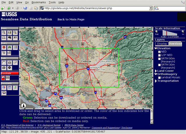
When the SDDS browser loads, you're presented with a map of the whole U.S., zoomed all the way out. The navigation options on the top left let you zoom in and out, and also let you select an area to zoom in on: click and hold, then drag the mouse to show the area you've outlined expanded in red or green.
Figure 6-25 shows a sample region selection in the SDDS, outlined in green. Whether the outline is red or green depends on whether it's possible to download data for that area directly from the SDDS, or whether you'll have to order hardcopy media. This in turn depends on how much data you want. If you select the 30 m SRTM data over a large area, which has high data density, you won't be able to download the whole set through Seamless. The SDDS also lets you zoom in directly to a state or a major city. Some local areas may have extra data available; for example, Sacramento, California, has a separate set of local orthophotos in addition to the U.S.-wide imagery.
Figure 6-25. Selecting a region to download via the SDDS
|

Once you've zoomed in to the extent you want to download data for, click the "Select Extent" icon on the lower left. Select a region as described earlier, and a Request Summary page will open, showing you the data sets available for that region, including data format and file size. Each data set is delivered as a ZIP file with an eight-digit filename, which contains all the relevant data and metadata. Download and unzip this file, and you should be able to load up the data set in a GIS browser like QGIS or GRASS right away.
The SDDS toolbar has a host of other nifty features. You can enter a lat/long pair in decimal format to zoom directly to that location. Or you can click on the map to get a lat/long coordinate for that point; unfortunately, this comes in degrees, minutes, and seconds! You can also measure distances between points and along a line that you describe by adding points. You can see elevation data for a point by clicking on the map, or you can create an elevation profile, a 2-D plot of the ground topography between the points, useful for line-of-sight evaluation for radio transmission.
The USGS Seamless Data Distribution System is an impressive example of how much can be done to alleviate data-access pain in a relatively low-tech, cross-browser fashion, with little more than JavaScript and flat images!
Mapping Your Life
- Hacks 1-13
- Hack 1. Put a Map on It: Mapping Arbitrary Locations with Online Services
- Hack 2. Route Planning Online
- Hack 3. Map the Places Youve Visited
- Hack 4. Find Your House on an Aerial Photograph
- Hack 5. The Road Less Traveled by in MapQuest
- Hack 6. Make Route Maps Easier to Read
- Hack 7. Will the Kids Barf?
- Hack 8. Publish Maps of Your Photos on the Web
- Hack 9. Track the Friendly Skies with Sherlock
- Hack 10. Georeference Digital Photos
- Hack 11. How Far? How Fast? Geo-Enabling Your Spreadsheet
- Hack 12. Create a Distance Grid in Excel
- Hack 13. Add Maps to Excel Spreadsheets with MapPoint
Mapping Your Neighborhood
- Hacks 14-21
- Hack 14. Make Free Maps of the United States Online
- Hack 15. Zoom Right In on Your Neighborhood
- Hack 16. Who Are the Neighbors Voting For?
- Hack 17. Map Nearby Wi-Fi Hotspots
- Hack 18. Why You Cant Watch Broadcast TV
- Hack 19. Analyze Elevation Profiles for Wireless Community Networks
- Hack 20. Make 3-D Raytraced Terrain Models
- Hack 21. Map Health Code Violations with RDFMapper
Mapping Your World
- Hacks 22-34
- Hack 22. Digging to China
- Hack 23. Explore David Rumseys Historical Maps
- Hack 24. Explore a 3-D Model of the Entire World
- Hack 25. Work with Multiple Lat/Long Formats
- Hack 26. Work with Different Coordinate Systems
- Hack 27. Calculate the Distance Between Points on the Earths Surface
- Hack 28. Experiment with Different Cartographic Projections
- Hack 29. Plot Arbitrary Points on a World Map
- Hack 30. Plot a Great Circle on a Flat Map
- Hack 31. Plot Dymaxion Maps in Perl
- Hack 32. Hack on Base Maps in Your Favorite Image Editor
- Hack 33. Georeference an Arbitrary Tourist Map
- Hack 34. Map Other Planets
Mapping (on) the Web
- Hacks 35-46
- Hack 35. Search Local, Find Global
- Hack 36. Shorten Online Map URLs
- Hack 37. Tweak the Look and Feel of Web Maps
- Hack 38. Add Location to Weblogs and RSS Feeds
- Hack 39. View Your Photo Thumbnails on a Flash Map
- Hack 40. Plot Points on a Spinning Globe Applet
- Hack 41. Plot Points on an Interactive Map Using DHTML
- Hack 42. Map Your Tracklogs on the Web
- Hack 43. Map Earthquakes in (Nearly) Real Time
- Hack 44. Plot Statistics Against Shapes
- Hack 45. Extract a Spatial Model from Wikipedia
- Hack 46. Map Global Weather Conditions
Mapping with Gadgets
- Hacks 47-63
- How GPS Works
- Hack 47. Get Maps on Your Mobile Phone
- Hack 48. Accessorize Your GPS
- Hack 49. Get Your Tracklogs in Windows or Linux
- Hack 50. The Serial Port to USB Conundrum
- Hack 51. Speak in Geotongues: GPSBabel to the Rescue
- Hack 52. Show Your Waypoints on Aerial Photos with Terrabrowser
- Hack 53. Visualize Your Tracks in Three Dimensions
- Hack 54. Create Your Own Maps for a Garmin GPS
- Hack 55. Use Your Track Memory as a GPS Base Map
- Hack 56. Animate Your Tracklogs
- Hack 57. Connect to Your GPS from Multiple Applications
- Hack 58. Dont Lose Your Tracklogs!
- Hack 59. Geocode Your Voice Recordings and Other Media
- Hack 60. Improve the Accuracy of Your GPS with Differential GPS
- Hack 61. Build a Map of Local GSM Cells
- Hack 62. Build a Car Computer
- Hack 63. Build Your Own Car Navigation System with GpsDrive
Mapping on Your Desktop
- Hacks 64-77
- Hack 64. Mapping Local Areas of Interest with Quantum GIS
- Hack 65. Extract Data from Maps with Manifold
- Hack 66. Java-Based Desktop Mapping with Openmap
- Hack 67. Seamless Data Download from the USGS
- Hack 68. Convert Geospatial Data Between Different Formats
- Hack 69. Find Your Way Around GRASS
- Hack 70. Import Your GPS Waypoints and Tracklogs into GRASS
- Hack 71. Turn Your Tracklogs into ESRI Shapefiles
- Hack 72. Add Relief to Your Topographic Maps
- Hack 73. Make Your Own Contour Maps
- Hack 74. Plot Wireless Network Viewsheds with GRASS
- Hack 75. Share Your GRASS Maps with the World
- Hack 76. Explore the Effects of Global Warming
- Conclusion
- Hack 77. Become a GRASS Ninja
Names and Places
- Hacks 78-86
- Hack 78. What to Do if Your Government Is Hoarding Geographic Data
- Hack 79. Geocode a U.S. Street Address
- Hack 80. Automatically Geocode U.S. Addresses
- Hack 81. Clean Up U.S. Addresses
- Hack 82. Find Nearby Things Using U.S. ZIP Codes
- Hack 83. Map Numerical Data the Easy Way
- Hack 84. Build a Free World Gazetteer
- Hack 85. Geocode U.S. Locations with the GNIS
- Hack 86. Track a Package Across the U.S.
Building the Geospatial Web
- Hacks 87-92
- Hack 87. Build a Spatially Indexed Data Store
- Hack 88. Load Your Waypoints into a Spatial Database
- Hack 89. Publish Your Geodata to the Web with GeoServer
- Hack 90. Crawl the Geospatial Web with RedSpider
- Hack 91. Build Interactive Web-Based Map Applications
- Hack 92. Map Wardriving (and other!) Data with MapServer
Mapping with Other People
- Hacks 93-100
- Hack 93. Node Runner
- Hack 94. Geo-Warchalking with 2-D Barcodes
- Hack 95. Model Interactive Spaces
- Hack 96. Share Geo-Photos on the Web
- Hack 97. Set Up an OpenGuide for Your Hometown
- Hack 98. Give Your Great-Great-Grandfather a GPS
- Hack 99. Map Your Friend-of-a-Friend Network
- Hack 100. Map Imaginary Places
EAN: 2147483647
Pages: 172
