Hack 61. Build a Map of Local GSM Cells


Use GPS to make maps of cell-tower locations and start building cheap location-based services.
Ever wanted to figure out where you are from the signals received by your mobile phone? The telecommunications companies, the emergency service providers, and, by extension, many "authorities" have access to this map of where mobile phone users are, where they have been, and where they are likely to be heading. Now you can build such a map for yourself and your friends!
From most Nokia phones, including older models, you can get the cell ID of the base tower you are connected to. Earlier models had a "monitor" mode that could scan for all available cell towers and their respective signal strengths; on later models, this has been locked down.
Fortunately, we can still get the current cell tower ID and signal strength from the phone, via Bluetooth or a serial cable, using an extended version of plain old AT modem commands! We used a Perl script to connect to the phone at intervalsevery seven seconds, though we were bicycling and could have set the interval as short as once per secondand ask it for its cell ID metadata, which includes a Location Area Code (LAC), and a Cell ID (CID). Taken together, the LAC and CID form a unique identifier for any cell in a wireless provider's national network.
The script, which we'll call cellstumbler.pl, uses an interface to the gpsd daemon to correlate mobile phone cell IDs with GPS coordinates. By running gpsd instead of connecting to the GPS directly from our script, we were able to use Kismet to talk to gpsd as well, to correlate Wi-Fi traces with GPS coordinates at the same time. See [Hack #57] for detailed instructions on running gpsd.
Also, you'll need the Device::Modem module from the CPAN to run this code. You can obtain it by running perl -MCPAN -e 'install Device::Modem' as root on your Linux system.
5.17.1. The Code
Here is the code contained in cellstumbler.pl:
#!/usr/bin/perl

use 5.6.1;
use IO::Socket;
use Device::Modem;
use Getopt::Std;
use strict;
use warnings;

BEGIN { $|++ }; # autoflush STDOUT.

# Read command line options.
my %opt;
getopt('gpr', \%opt);

# Set parameters based on command line options, with defaults.
my $GPSD = $opt{g} || "localhost:2947";
my $GSM_Port = $opt{p} || "/dev/ttyS0";
my $GSM_Baud = $opt{b} || 115_200;
my $Rate = $opt{r} || 1;

# Connect to gpsd.
my $gps = IO::Socket::INET->new($GPSD)
 or die "Can't connect to gpsd at $GPSD: $!
";

# Connect to the cell phone.
my $gsm = Device::Modem->new( port => $GSM_Port );
$gsm->connect( baudrate => $GSM_Baud )
 or die "Can't connect to modem on $GSM_Port: $!
";

# Tell the cell phone we want all the network registration data it has.
$gsm->reset;
$gsm->atsend( "AT+CREG=2
" );
die "AT+CREG not recognized by modem on $GSM_Port"
 unless $gsm->answer eq "OK";

while (1) {
 # Tell gpsd we want position, date, and status.
 $gps->print("pds
");

 # Parse out the response. If the date is blank, gpsd needs a second to catch up.
 my $location = <$gps>;
 my ($lat, $long, $date, $status) =
 ($location =~ /P=(.+?) (.+?),D=(.+?),S=(.+?)/gos);
 next unless $date;

 # Turn the date into an RFC 2445 ICal date string.
 my ($mo, $d, $y, $h, $m, $s) = split /[ /:]/o, $date;
 $date = "${y}${mo}${d}T${h}${m}${s}Z";

 # Query cell ID and location area code.
 $gsm->atsend( "AT+CREG?
" );
 my ($cid, $lac) = ($gsm->answer =~ /"([dA-F]{4})"/gios);

 # Query signal strength.
 $gsm->atsend( "AT+CSQ
" );
 my ($signal) = ($gsm->answer =~ /(d+)/gos);
 $signal = -113 + $signal * 2;

 # Print a line of data and wait.
 print join(",", $date, $status, $lat, $long,
 hex($cid), hex($lac), $signal), "
";
 sleep( $Rate );
}
5.17.2. Running the Code
As mentioned earlier, you need to have gpsd running before starting cellstumbler.pl. We used a Bluetooth RFCOMM serial connection to talk to a Nokia 3650, so we had to bind an RFCOMM port first, using the six-part Bluetooth ID of the phone. You can use hcitool scan in Linux to search for the Bluetooth ID of your phone. If your phone doesn't have Bluetooth, then you'll need a serial cable, but you can skip the whole RFCOMM bit. You may need to use a terminal program like minicom to poke around your system's serial ports to figure out which the phone is accessible on. You'll know it's working when you type AT into the terminal program, and get an OK from the phone in response.
Finally, assuming cellstumbler.pl is in the current directory and marked as executable, you can start it like this, where xx:xx etc is the Bluetooth ID of your phone:
$ rfcomm bind /dev/rfcomm0 xx:xx:xx:xx:xx:xx
$ ./cellstumbler.pl -p /dev/rfcomm0 -r 5 > cell_data.txt
In this particular case, we're telling cellstumbler.pl to talk to the phone on the /dev/rfcomm0 serial port with the -p option and to collect a sample every five seconds with the -r option. There's a -b option available in case you need to explicitly set the baud rate on the serial line to the phone, and a -g option, just in case you're running gpsd on a different port (or different machine!) than the default.
If you want to see the cell ID data go by as you collect it, you can use the very handy tee shell command:
$ ./cellstumbler.pl -p /dev/rfcomm0 | tee cell_data.txt
The standard output of cellstumbler.pl contains one sample per line, with seven comma-separated fields. In order, they are:
timestamp (in iCal format)
GPS status
latitude
longitude
CID (in hexadecimal)
LAC (in hexadecimal)
signal strength (measured in dBm)
The value in the GPS status field is returned directly from gpsd, which will be 0 if the GPS has no satellite lock, 1 if it has a satellite lock, and 2 if the location reading is differentially corrected (e,g,, via a WAAS signal).
5.17.3. Evaluating the Data
Given a set of readings of the ID of some radio frequency beacon and its signal strength, and the latitude and longitude and time at which the measurement was taken, how can we figure out where the radio antennas are? We could start with a naive interpolation technique that doesn't even make use of the signal strength data.
First, we convert the latitude and longitude from the GPS readings into UTM, to make Cartesian calculations easier. (See [Hack #26] for more details on this process.) We take the numerical average of all the GPS points collected for the same cell-ID reading, and call this the "center" of the cell. We take the distance from the center of the cell to the matching point farthest away and make that the radius of the circle. It's a quick-and-dirty technique, but it will give approximate "good-enough" measurements for many kinds of spatial navigation in urban areas: a map of a surrounding 500m radius, or interesting places less than half a mile's walk away.
We can get better results based on signal strength and by using more interesting algorithms, such as inverse distance weighting and particle filters. We also have to be aware of problems or flaws in different radio technologies. Buildings and trees block lines of sight and dampen or divert radio waves; our perfect circles are more likely to be distended blobs. Intel's PlaceLab project implements some of these more advanced techniques; you can find PlaceLab's source code at http://placelab.org.
These same techniques are equally viable for making RF frequency maps for other channels and protocols, particularly 802.11 wireless. As mentioned previously, while cellstumbling for mobile phone base stations, we also used Kismet to talk to gpsd and collect readings for 802.11 access points, including information about whether they provide open service and offer DHCP addresses.
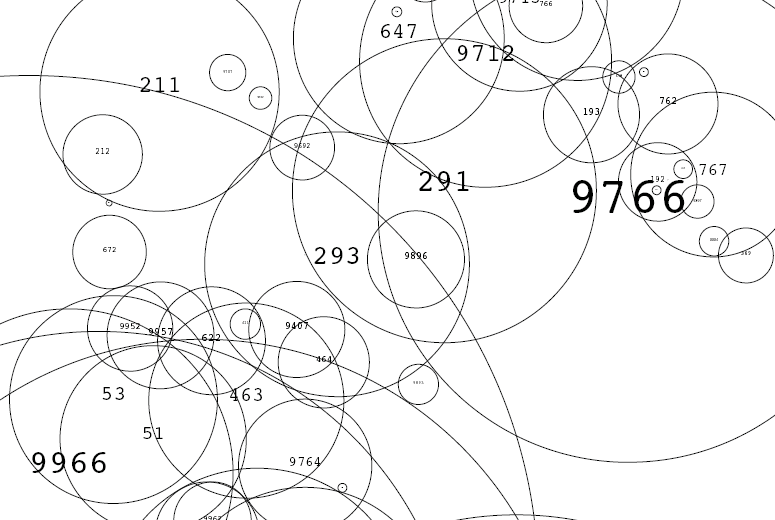
Now that we've gathered all this data, we might want to submit it to a repository, to make it useful for other applications or to visualize it. Figure 5-37 shows part of a simple map we made with the support of RIXC, a Latvian cultural organization (http://rixc.lv), showing cellular reception in central Riga. The map, made in SVG, depicts a circle representing each centroid, with a label for each cell ID. An obvious next step for this "bubble diagram" would be to plot it over a base map of the area to provide context.
Figure 5-37. Part of an SVG bubble diagram of Riga's cellular network
Envision the possibilities that can blossom when individuals go out, collect cell ID samples, and compile them together in a collaborative database. Suddenly, applications can be written for smart phones, like those running the Symbian OS, which can look up a user's location in a database simply by examining the current cell ID, with no need for a GPS on the phone. You can explore this idea further at http://mappinghacks.com/cell/, where we provide a demo of a small web service that allows people to upload files full of points or post individual points in real time. The full sources of the various scripts described herefor calculating centroids, generating SVG bubble diagrams, and so onare available on the site as well.
5.17.4. See Also:
- Intel Research's free placelab product has GSM spotting capacitiessee http://placelab.org/
- Cellspotting is another collaborative cellstumbling resourcesee http://cellspotting.org/
Mapping Your Life
- Hacks 1-13
- Hack 1. Put a Map on It: Mapping Arbitrary Locations with Online Services
- Hack 2. Route Planning Online
- Hack 3. Map the Places Youve Visited
- Hack 4. Find Your House on an Aerial Photograph
- Hack 5. The Road Less Traveled by in MapQuest
- Hack 6. Make Route Maps Easier to Read
- Hack 7. Will the Kids Barf?
- Hack 8. Publish Maps of Your Photos on the Web
- Hack 9. Track the Friendly Skies with Sherlock
- Hack 10. Georeference Digital Photos
- Hack 11. How Far? How Fast? Geo-Enabling Your Spreadsheet
- Hack 12. Create a Distance Grid in Excel
- Hack 13. Add Maps to Excel Spreadsheets with MapPoint
Mapping Your Neighborhood
- Hacks 14-21
- Hack 14. Make Free Maps of the United States Online
- Hack 15. Zoom Right In on Your Neighborhood
- Hack 16. Who Are the Neighbors Voting For?
- Hack 17. Map Nearby Wi-Fi Hotspots
- Hack 18. Why You Cant Watch Broadcast TV
- Hack 19. Analyze Elevation Profiles for Wireless Community Networks
- Hack 20. Make 3-D Raytraced Terrain Models
- Hack 21. Map Health Code Violations with RDFMapper
Mapping Your World
- Hacks 22-34
- Hack 22. Digging to China
- Hack 23. Explore David Rumseys Historical Maps
- Hack 24. Explore a 3-D Model of the Entire World
- Hack 25. Work with Multiple Lat/Long Formats
- Hack 26. Work with Different Coordinate Systems
- Hack 27. Calculate the Distance Between Points on the Earths Surface
- Hack 28. Experiment with Different Cartographic Projections
- Hack 29. Plot Arbitrary Points on a World Map
- Hack 30. Plot a Great Circle on a Flat Map
- Hack 31. Plot Dymaxion Maps in Perl
- Hack 32. Hack on Base Maps in Your Favorite Image Editor
- Hack 33. Georeference an Arbitrary Tourist Map
- Hack 34. Map Other Planets
Mapping (on) the Web
- Hacks 35-46
- Hack 35. Search Local, Find Global
- Hack 36. Shorten Online Map URLs
- Hack 37. Tweak the Look and Feel of Web Maps
- Hack 38. Add Location to Weblogs and RSS Feeds
- Hack 39. View Your Photo Thumbnails on a Flash Map
- Hack 40. Plot Points on a Spinning Globe Applet
- Hack 41. Plot Points on an Interactive Map Using DHTML
- Hack 42. Map Your Tracklogs on the Web
- Hack 43. Map Earthquakes in (Nearly) Real Time
- Hack 44. Plot Statistics Against Shapes
- Hack 45. Extract a Spatial Model from Wikipedia
- Hack 46. Map Global Weather Conditions
Mapping with Gadgets
- Hacks 47-63
- How GPS Works
- Hack 47. Get Maps on Your Mobile Phone
- Hack 48. Accessorize Your GPS
- Hack 49. Get Your Tracklogs in Windows or Linux
- Hack 50. The Serial Port to USB Conundrum
- Hack 51. Speak in Geotongues: GPSBabel to the Rescue
- Hack 52. Show Your Waypoints on Aerial Photos with Terrabrowser
- Hack 53. Visualize Your Tracks in Three Dimensions
- Hack 54. Create Your Own Maps for a Garmin GPS
- Hack 55. Use Your Track Memory as a GPS Base Map
- Hack 56. Animate Your Tracklogs
- Hack 57. Connect to Your GPS from Multiple Applications
- Hack 58. Dont Lose Your Tracklogs!
- Hack 59. Geocode Your Voice Recordings and Other Media
- Hack 60. Improve the Accuracy of Your GPS with Differential GPS
- Hack 61. Build a Map of Local GSM Cells
- Hack 62. Build a Car Computer
- Hack 63. Build Your Own Car Navigation System with GpsDrive
Mapping on Your Desktop
- Hacks 64-77
- Hack 64. Mapping Local Areas of Interest with Quantum GIS
- Hack 65. Extract Data from Maps with Manifold
- Hack 66. Java-Based Desktop Mapping with Openmap
- Hack 67. Seamless Data Download from the USGS
- Hack 68. Convert Geospatial Data Between Different Formats
- Hack 69. Find Your Way Around GRASS
- Hack 70. Import Your GPS Waypoints and Tracklogs into GRASS
- Hack 71. Turn Your Tracklogs into ESRI Shapefiles
- Hack 72. Add Relief to Your Topographic Maps
- Hack 73. Make Your Own Contour Maps
- Hack 74. Plot Wireless Network Viewsheds with GRASS
- Hack 75. Share Your GRASS Maps with the World
- Hack 76. Explore the Effects of Global Warming
- Conclusion
- Hack 77. Become a GRASS Ninja
Names and Places
- Hacks 78-86
- Hack 78. What to Do if Your Government Is Hoarding Geographic Data
- Hack 79. Geocode a U.S. Street Address
- Hack 80. Automatically Geocode U.S. Addresses
- Hack 81. Clean Up U.S. Addresses
- Hack 82. Find Nearby Things Using U.S. ZIP Codes
- Hack 83. Map Numerical Data the Easy Way
- Hack 84. Build a Free World Gazetteer
- Hack 85. Geocode U.S. Locations with the GNIS
- Hack 86. Track a Package Across the U.S.
Building the Geospatial Web
- Hacks 87-92
- Hack 87. Build a Spatially Indexed Data Store
- Hack 88. Load Your Waypoints into a Spatial Database
- Hack 89. Publish Your Geodata to the Web with GeoServer
- Hack 90. Crawl the Geospatial Web with RedSpider
- Hack 91. Build Interactive Web-Based Map Applications
- Hack 92. Map Wardriving (and other!) Data with MapServer
Mapping with Other People
- Hacks 93-100
- Hack 93. Node Runner
- Hack 94. Geo-Warchalking with 2-D Barcodes
- Hack 95. Model Interactive Spaces
- Hack 96. Share Geo-Photos on the Web
- Hack 97. Set Up an OpenGuide for Your Hometown
- Hack 98. Give Your Great-Great-Grandfather a GPS
- Hack 99. Map Your Friend-of-a-Friend Network
- Hack 100. Map Imaginary Places
EAN: 2147483647
Pages: 172
