Hack 96. Share Geo-Photos on the Web


Share your geo-referenced images with the web-wide world in various forms.
Once, with some help from [Hack #10], you've gotten the hang of producing georeferenced photos, you'll want to take the next step by publishing them to your web site or to other collaborative photo services. As the geo-photo community has grown, so has the list of ways to publish your photos for others to see.
GeoSnapper (http://geosnapper.com/) and WWMX (http://wwmx.org/) are both services that try to ease the GPS-linking problem by providing tools to process your raw tracklog and photos. WWMX is a Microsoft product and works really well, but is based on the .NET framework, so it will only run on modern Windows operating systems. GeoSnapper works as a web service, and it will work for you as long as you have your tracklogs downloaded to your computer as Garmin MapSource or MacGPS Pro formats. [Hack #51] discusses GPSBabel, an excellent free cross-platform program that will simplify downloading tracks from your GPS and converting them between different common formats. It comes highly recommended!
http://locative.us/photomap/ holds the two Perl scripts that we wrote to produce photo maps and publish spatial metadata about photographs on the Web. The process happens in two parts. First, we create an RDF feed of metadata that describes the images and tags them with place and timestamps. Second, we use the RDF feed to plot the photographs over a base-map layer. Visit http://locative.us/photomap/ to download the two scripts, one named geoloc_media.pl and the other plot_rdf.pl. To run them, you need to have several Perl modules installed from the CPAN code archive: Geo::Track::Log, SVG, Image::EXIF, XML::Simple and RDF::Simple. [Hack #97] offers detailed instructions on the easy process of downloading and installing Perl code from CPAN. If you've been working through the hacks in this book, you'll have most of these modules installed already.
9.5.1. Create an RDF Feed of Photo Metadata
The first Perl script, geoloc_media.pl, takes a set of images and a GPS track in GPX format and spits out an RDF description of the images, annotated with time and place stamps and the creator's details.
This script assumes that you have a directory full of images that were taken while recording a tracklog with your GPS. You need to provide an address where that directory is available on the Web; this helps to uniquely identify different pictures and allows others to make descriptions of them.
The script needs to be run with several parameters:
perl geoloc_media.pl
  ...
- An offset: the difference between the time on the camera and the time on the GPS. Ideally, you'll have synchronized them first; otherwise you can figure out the offset by looking at what they both claim the current time is.
|

- The name of the directory on the Web in which the photos can be found.
- The name of your GPS tracklog file in GPX format. This is a simple XML format for GPS traces. GPSBabel will convert most common formats into GPX.
- The email address of the person who took the photos.
- The names of the files. If they are in a directory, it's easy to enter these with a wildcard: my_photos/*
Here's a sample run of the geoloc_media.pl script:
perl geoloc_media.pl
2.5
http://frot.org/20041020/ 20041020.gpx zool@frot.org /www/frot.org/20041020/* > photos.rdf
The end of this sequence, > photos.rdf, sends the output of the script to a file. What the script spits out is a set of locative packets that describes the photographs: where they were taken, when they were taken, and who took them. See [Hack #95] for advice on modeling spatial information in RDF. Here's a short sample of an RDF description of photographs taken in Utrecht, September 2004:
 5.125718
 52.084616


 20040906T134632
In English, this description says, "Here is some context about a point in space at latitude 5.1257 and longitude 52.0846. There is a piece of media attached to it. The piece of media was created at this time, and the person who created it has the email address zool@frot.org."
9.5.2. Create a Dynamic SVG Map with Pop-Up Photographs
Now that we have all that nice photo metadata, what can we do with it other than share it? One quick way to see your photos in relation to a map is to plot them on it using the Scalable Vector Graphics (SVG) format.
The second script, plot_rdf.pl takes the RDF/XML file output by the first script and another file describing a base map with its orientation, and overlays the photos on the map.
This is a slightly more complex task, as first we have to acquire a base map and know how it is georeferenced. That is, we need to know the coordinates of the top left corner, what the extents of the image represent in terms of geographical space, and how the map is skewed or rotated with respect to True North. What a mouthful!
Luckily, we've already thought of this, and [Hack #33] demonstrates the appropriate technique. The JavaScript-based client provided for the hack, available at http://mappinghacks.com/georeference/, allows you to figure out the spatial extent of an image, provided that you have three known points that you can identify on it. The client spits out a series of six numbers known as an affine transformation, which shows how your map is projected in relation to geographical space.
Use the six numbers to create an XML file that looks like the following example, providing a simple description of your map image: its name, its size, and the transformation that the map went through in relation to geographical space. This is the XML file that was used to create a photo map for the GPS/photo info mentioned earlier:
utreg.gif
890
684
10000

 0.549457004709508 -0.0298986308382459 0.0250666506000045 -0.52601105571061
-2699.47952280242 2028.02835472852
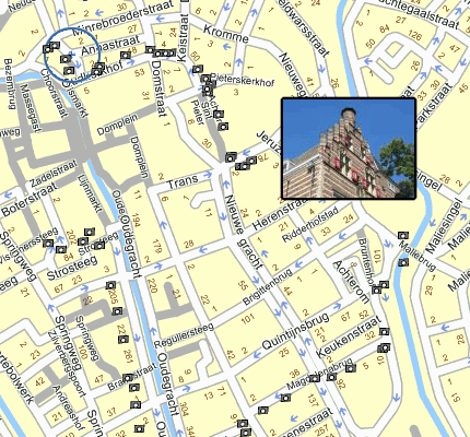
Finally, you're ready to create a SVG photo-overlaid map. Take the second script, plot_rdf.pl, and run it with the XML image file as the first parameter, and the RDF description of your photographs as the second. It will spit out an SVG file that uses your map as a base layer and has an icon for each photograph, which expands to show a photo thumbnail when you move your mouse over it, as shown in Figure 9-8:
perl plot_rdf.pl utreg.xml utreg.rdf > map.svg
Figure 9-8. A dynamic map with photos appearing as tooltips
|
9.5.3. See Also
http://www.akuaku.org/archives/2004/10/bluetooth_gps_m.shtml
Dav Coleman's write-up of taking geo-annotated photos in real time using a camera phone and a Bluetooth GPS
http://flickr.org/
Flickr, a photo-sharing site
http://geolicious.com/
Geolicious, a spatial-media-annotating site.
http://www.akuaku.org/archives/2003/05/gps_tagged_jpeg.shtml
GPS EXIF metadata
http://mappr.com
Mappr, a tool for georeferencing Flickr photos by looking up tags in a gazetteer of world place names
Mapping Your Life
- Hacks 1-13
- Hack 1. Put a Map on It: Mapping Arbitrary Locations with Online Services
- Hack 2. Route Planning Online
- Hack 3. Map the Places Youve Visited
- Hack 4. Find Your House on an Aerial Photograph
- Hack 5. The Road Less Traveled by in MapQuest
- Hack 6. Make Route Maps Easier to Read
- Hack 7. Will the Kids Barf?
- Hack 8. Publish Maps of Your Photos on the Web
- Hack 9. Track the Friendly Skies with Sherlock
- Hack 10. Georeference Digital Photos
- Hack 11. How Far? How Fast? Geo-Enabling Your Spreadsheet
- Hack 12. Create a Distance Grid in Excel
- Hack 13. Add Maps to Excel Spreadsheets with MapPoint
Mapping Your Neighborhood
- Hacks 14-21
- Hack 14. Make Free Maps of the United States Online
- Hack 15. Zoom Right In on Your Neighborhood
- Hack 16. Who Are the Neighbors Voting For?
- Hack 17. Map Nearby Wi-Fi Hotspots
- Hack 18. Why You Cant Watch Broadcast TV
- Hack 19. Analyze Elevation Profiles for Wireless Community Networks
- Hack 20. Make 3-D Raytraced Terrain Models
- Hack 21. Map Health Code Violations with RDFMapper
Mapping Your World
- Hacks 22-34
- Hack 22. Digging to China
- Hack 23. Explore David Rumseys Historical Maps
- Hack 24. Explore a 3-D Model of the Entire World
- Hack 25. Work with Multiple Lat/Long Formats
- Hack 26. Work with Different Coordinate Systems
- Hack 27. Calculate the Distance Between Points on the Earths Surface
- Hack 28. Experiment with Different Cartographic Projections
- Hack 29. Plot Arbitrary Points on a World Map
- Hack 30. Plot a Great Circle on a Flat Map
- Hack 31. Plot Dymaxion Maps in Perl
- Hack 32. Hack on Base Maps in Your Favorite Image Editor
- Hack 33. Georeference an Arbitrary Tourist Map
- Hack 34. Map Other Planets
Mapping (on) the Web
- Hacks 35-46
- Hack 35. Search Local, Find Global
- Hack 36. Shorten Online Map URLs
- Hack 37. Tweak the Look and Feel of Web Maps
- Hack 38. Add Location to Weblogs and RSS Feeds
- Hack 39. View Your Photo Thumbnails on a Flash Map
- Hack 40. Plot Points on a Spinning Globe Applet
- Hack 41. Plot Points on an Interactive Map Using DHTML
- Hack 42. Map Your Tracklogs on the Web
- Hack 43. Map Earthquakes in (Nearly) Real Time
- Hack 44. Plot Statistics Against Shapes
- Hack 45. Extract a Spatial Model from Wikipedia
- Hack 46. Map Global Weather Conditions
Mapping with Gadgets
- Hacks 47-63
- How GPS Works
- Hack 47. Get Maps on Your Mobile Phone
- Hack 48. Accessorize Your GPS
- Hack 49. Get Your Tracklogs in Windows or Linux
- Hack 50. The Serial Port to USB Conundrum
- Hack 51. Speak in Geotongues: GPSBabel to the Rescue
- Hack 52. Show Your Waypoints on Aerial Photos with Terrabrowser
- Hack 53. Visualize Your Tracks in Three Dimensions
- Hack 54. Create Your Own Maps for a Garmin GPS
- Hack 55. Use Your Track Memory as a GPS Base Map
- Hack 56. Animate Your Tracklogs
- Hack 57. Connect to Your GPS from Multiple Applications
- Hack 58. Dont Lose Your Tracklogs!
- Hack 59. Geocode Your Voice Recordings and Other Media
- Hack 60. Improve the Accuracy of Your GPS with Differential GPS
- Hack 61. Build a Map of Local GSM Cells
- Hack 62. Build a Car Computer
- Hack 63. Build Your Own Car Navigation System with GpsDrive
Mapping on Your Desktop
- Hacks 64-77
- Hack 64. Mapping Local Areas of Interest with Quantum GIS
- Hack 65. Extract Data from Maps with Manifold
- Hack 66. Java-Based Desktop Mapping with Openmap
- Hack 67. Seamless Data Download from the USGS
- Hack 68. Convert Geospatial Data Between Different Formats
- Hack 69. Find Your Way Around GRASS
- Hack 70. Import Your GPS Waypoints and Tracklogs into GRASS
- Hack 71. Turn Your Tracklogs into ESRI Shapefiles
- Hack 72. Add Relief to Your Topographic Maps
- Hack 73. Make Your Own Contour Maps
- Hack 74. Plot Wireless Network Viewsheds with GRASS
- Hack 75. Share Your GRASS Maps with the World
- Hack 76. Explore the Effects of Global Warming
- Conclusion
- Hack 77. Become a GRASS Ninja
Names and Places
- Hacks 78-86
- Hack 78. What to Do if Your Government Is Hoarding Geographic Data
- Hack 79. Geocode a U.S. Street Address
- Hack 80. Automatically Geocode U.S. Addresses
- Hack 81. Clean Up U.S. Addresses
- Hack 82. Find Nearby Things Using U.S. ZIP Codes
- Hack 83. Map Numerical Data the Easy Way
- Hack 84. Build a Free World Gazetteer
- Hack 85. Geocode U.S. Locations with the GNIS
- Hack 86. Track a Package Across the U.S.
Building the Geospatial Web
- Hacks 87-92
- Hack 87. Build a Spatially Indexed Data Store
- Hack 88. Load Your Waypoints into a Spatial Database
- Hack 89. Publish Your Geodata to the Web with GeoServer
- Hack 90. Crawl the Geospatial Web with RedSpider
- Hack 91. Build Interactive Web-Based Map Applications
- Hack 92. Map Wardriving (and other!) Data with MapServer
Mapping with Other People
- Hacks 93-100
- Hack 93. Node Runner
- Hack 94. Geo-Warchalking with 2-D Barcodes
- Hack 95. Model Interactive Spaces
- Hack 96. Share Geo-Photos on the Web
- Hack 97. Set Up an OpenGuide for Your Hometown
- Hack 98. Give Your Great-Great-Grandfather a GPS
- Hack 99. Map Your Friend-of-a-Friend Network
- Hack 100. Map Imaginary Places
EAN: 2147483647
Pages: 172
