Hack 65. Extract Data from Maps with Manifold


Just getting map data isn't enough to give you all the information the map might contain. If you're working with complex data, a GUI interface that lets you select the areas you consider relevant and then calculate the results can be extremely convenientif you can do it cheaply!
Manifold (http://manifold.net), a Windows-based GIS application, costs $245 but offers much of the same functionality as its "traditional" but much more expensive GIS counterparts. It can read a wide variety of map formats and provides a user interface that's deliberately familiar to people who work in Windows. You can open a map, select the bits in which you're interested, and do quick calculations on the data associated with your selected areas. Manifold also lets you create maps and perform sophisticated analysis, though this hack doesn't have the space to go into that.
For a recent project, I needed to know the population and number of houses in a specific area. While I've usually been able to get that kind of information from the American Fact Finder web site (http://factfinder.census.gov/home/saff/main.html?_lang=en), making effective use of that prepackaged data means that the areas you're interested in have to match up with the places defined by the Census Bureau. In my case, since I was trying to calculate the population of the hamlet of Varna, New York, a place with no municipal government, the prepackaged data wasn't much help. Instead, I turned to census block data available through maps at the Cornell University Geospatial Repository (CUGIR, at http://cugir.mannlib.cornell.edu/) and created a cluster of blocks that roughly corresponded to the boundaries of the hamlet.
The first step was getting the information I needed. In my case, that meant visiting http://new-gis.mannlib.cornell.edu/CUGIR_Data/cens2000/109blk00s.zip (a file that contains census block maps and data for Tompkins County, where Varna is) and extracting its contents. There are several files in there, but the primary ones I needed to work with were tgr109blk00s.shp (the shapefile) and tgr109blk00s.dbf (the underlying datafile).
To try this project yourself, download and extract the census block maps and open Manifold. Create a new project (through File images/ent/U2192.GIF border=0> New) and go to File
images/ent/U2192.GIF border=0> Import
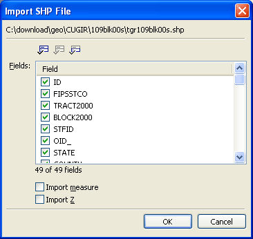
images/ent/U2192.GIF border=0> Drawing to open the shapefile. When you choose the shapefile, Manifold also imports the data from the database file. It asks which pieces you want, as shown in Figure 6-8.
Figure 6-8. Importing data with a shapefile in Manifold
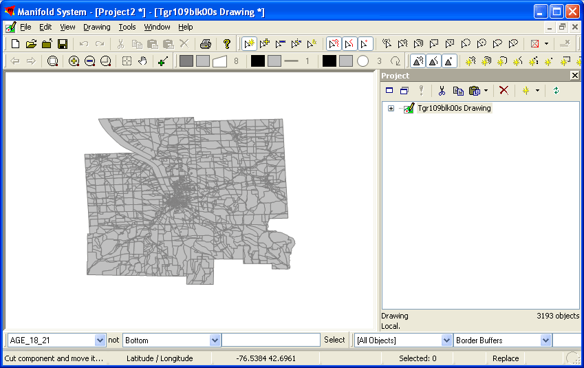
You can then open the drawing and double-click on "Tgr109blks00s Drawing" in the Project pane at right, displaying the census blocks of Tompkins County, as shown in Figure 6-9.
Figure 6-9. A county worth of census blocks
To zoom in, click the magnifying glass with the plus sign in it and then click on the map where you'd like to see more detail. Figure 6-10 shows a closer view of Varna, which is centered roughly on -76.4363, 42.4561.
Figure 6-10. Zooming in on Varna

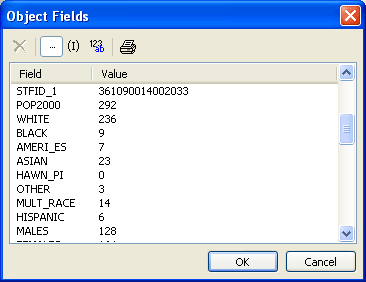
After turning off the magnification cursor (by clicking on the magnifying glass with the plus sign in it again), you can select a parcel and then examine its field. Click on a parcel to select it (it will turn red) and then right-click it and select "Fields..." If you scroll down the dialog box that appears, you'll see the data for that particular census block, as shown in Figure 6-11.
Figure 6-11. Data for one census block in Varna
|

The next step was to select census blocks that correspond to Varna. In the Comprehensive Plan I was working with, the "hamlet area" of Varna was defined as the set of parcels shown in Figure 6-12.
Figure 6-12. Varna, defined as tax parcels
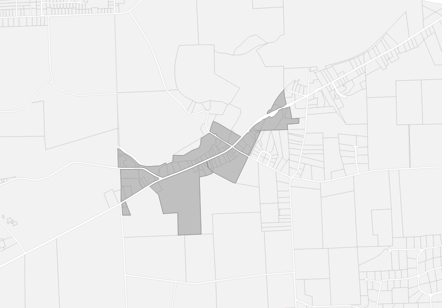
Those parcels don't precisely map to census blocks, unfortunately, but the problem is manageable because the parts of the blocks that extend beyond the parcels are largely uninhabited. (It's much easier to do reliable map processing when you can check out the area physically on occasion.) Selecting all the parcels that contain the Varna hamlet area by Control-clicking produces the selection shown in Figure 6-13.
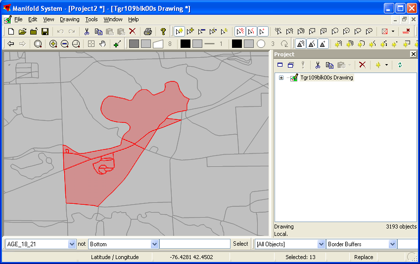
Figure 6-13. Varna, defined as a collection of census blocks
The easiest way to calculate the total population for this area is combine all of these blocks into a single selection. Rather than making the change to the original map, copy the blocks. Then, go to File images/ent/U2192.GIF border=0> Create
images/ent/U2192.GIF border=0> Drawing and create a drawing named VarnaCoreBlocks or something similar. You'll need to double-click it in the Project pane at right to open it, and then paste in your blocks. Manifold will show you that it's adding data to the table with a dialog box like that shown in Figure 6-14, and the result will look like Figure 6-15.
Figure 6-14. Data being pasted
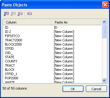
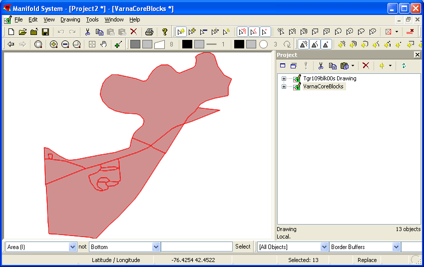
Figure 6-15. Varna's census blocks, isolated
The easiest way to get totals for the information in these blocks is to dissolve them into a single large piece. The Drawing menu's "Dissolve..." option does just this. When you select it, you'll see a dialog box like that shown in Figure 6-16.
Figure 6-16. Choosing a field for dissolving boundaries
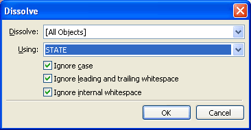
In this case, the point is simply to dissolve all of the boundaries, but Manifold expects that people will be somewhat more selective. You can choose between [All Objects] and [Selected Objects], letting you dissolve across an entire drawing or just selected parts. You can also choose a field to match on for combining objects. To dissolve all the boundaries, choose a field in which all the values for the field are identical. In this case, STATE will work fine, since all of the pieces are in New York State. Clicking OK produces the result shown in Figure 6-17, and showing the fields for that one area produces the result shown in Figure 6-18.
Figure 6-17. Varna census blocks dissolved into a single object
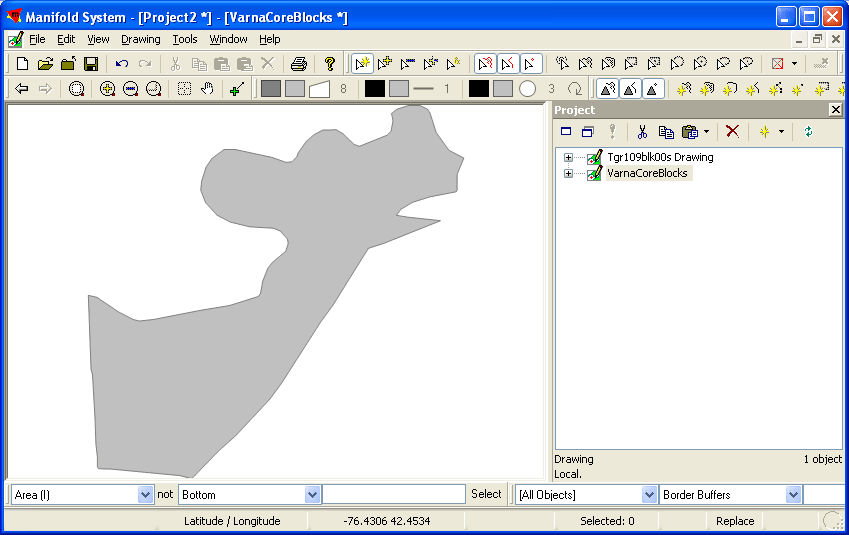
Figure 6-18. The totaled fields for that single object's census data
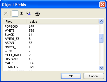
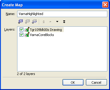
The population of Varna, as defined by the plan noted earlier, is 679 people, according to the 2000 census. (Because Manifold adds all the values, the averages included in the data don't come out so well and need to be recalculated.) One final nice touch is that you can combine the new drawing with the old one to create a map that highlights the area chosen for calculation. In Manifold, go to File images/ent/U2192.GIF border=0> Create
images/ent/U2192.GIF border=0> Map..., and select the two drawings, as shown in Figure 6-19.
Figure 6-19. Creating a map with two layers of drawings
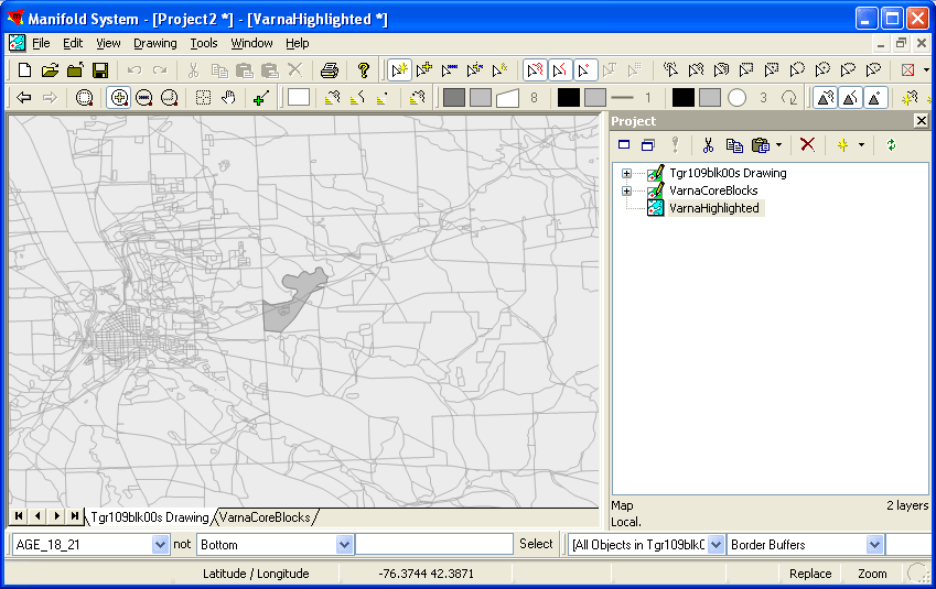
Open the map you've created and then right-click on the tab for "Tgr109blk00s Drawing." Choose "Opacity..." from the menu that appears, and set it to 30%. If you then zoom in a little, you'll see the darker Varna area standing out against the surrounding blocks, and the divisions for the blocks it contains are still visible, as shown in Figure 6-20.
Figure 6-20. Two related maps at different levels of opacity, highlighting the area on which calculations were made
This is barely scratching the surface of the kinds of things you can do with Manifold, which lets you create, edit, and analyze maps in ways this hack can't begin to explain.
Simon St.Laurent
Mapping Your Life
- Hacks 1-13
- Hack 1. Put a Map on It: Mapping Arbitrary Locations with Online Services
- Hack 2. Route Planning Online
- Hack 3. Map the Places Youve Visited
- Hack 4. Find Your House on an Aerial Photograph
- Hack 5. The Road Less Traveled by in MapQuest
- Hack 6. Make Route Maps Easier to Read
- Hack 7. Will the Kids Barf?
- Hack 8. Publish Maps of Your Photos on the Web
- Hack 9. Track the Friendly Skies with Sherlock
- Hack 10. Georeference Digital Photos
- Hack 11. How Far? How Fast? Geo-Enabling Your Spreadsheet
- Hack 12. Create a Distance Grid in Excel
- Hack 13. Add Maps to Excel Spreadsheets with MapPoint
Mapping Your Neighborhood
- Hacks 14-21
- Hack 14. Make Free Maps of the United States Online
- Hack 15. Zoom Right In on Your Neighborhood
- Hack 16. Who Are the Neighbors Voting For?
- Hack 17. Map Nearby Wi-Fi Hotspots
- Hack 18. Why You Cant Watch Broadcast TV
- Hack 19. Analyze Elevation Profiles for Wireless Community Networks
- Hack 20. Make 3-D Raytraced Terrain Models
- Hack 21. Map Health Code Violations with RDFMapper
Mapping Your World
- Hacks 22-34
- Hack 22. Digging to China
- Hack 23. Explore David Rumseys Historical Maps
- Hack 24. Explore a 3-D Model of the Entire World
- Hack 25. Work with Multiple Lat/Long Formats
- Hack 26. Work with Different Coordinate Systems
- Hack 27. Calculate the Distance Between Points on the Earths Surface
- Hack 28. Experiment with Different Cartographic Projections
- Hack 29. Plot Arbitrary Points on a World Map
- Hack 30. Plot a Great Circle on a Flat Map
- Hack 31. Plot Dymaxion Maps in Perl
- Hack 32. Hack on Base Maps in Your Favorite Image Editor
- Hack 33. Georeference an Arbitrary Tourist Map
- Hack 34. Map Other Planets
Mapping (on) the Web
- Hacks 35-46
- Hack 35. Search Local, Find Global
- Hack 36. Shorten Online Map URLs
- Hack 37. Tweak the Look and Feel of Web Maps
- Hack 38. Add Location to Weblogs and RSS Feeds
- Hack 39. View Your Photo Thumbnails on a Flash Map
- Hack 40. Plot Points on a Spinning Globe Applet
- Hack 41. Plot Points on an Interactive Map Using DHTML
- Hack 42. Map Your Tracklogs on the Web
- Hack 43. Map Earthquakes in (Nearly) Real Time
- Hack 44. Plot Statistics Against Shapes
- Hack 45. Extract a Spatial Model from Wikipedia
- Hack 46. Map Global Weather Conditions
Mapping with Gadgets
- Hacks 47-63
- How GPS Works
- Hack 47. Get Maps on Your Mobile Phone
- Hack 48. Accessorize Your GPS
- Hack 49. Get Your Tracklogs in Windows or Linux
- Hack 50. The Serial Port to USB Conundrum
- Hack 51. Speak in Geotongues: GPSBabel to the Rescue
- Hack 52. Show Your Waypoints on Aerial Photos with Terrabrowser
- Hack 53. Visualize Your Tracks in Three Dimensions
- Hack 54. Create Your Own Maps for a Garmin GPS
- Hack 55. Use Your Track Memory as a GPS Base Map
- Hack 56. Animate Your Tracklogs
- Hack 57. Connect to Your GPS from Multiple Applications
- Hack 58. Dont Lose Your Tracklogs!
- Hack 59. Geocode Your Voice Recordings and Other Media
- Hack 60. Improve the Accuracy of Your GPS with Differential GPS
- Hack 61. Build a Map of Local GSM Cells
- Hack 62. Build a Car Computer
- Hack 63. Build Your Own Car Navigation System with GpsDrive
Mapping on Your Desktop
- Hacks 64-77
- Hack 64. Mapping Local Areas of Interest with Quantum GIS
- Hack 65. Extract Data from Maps with Manifold
- Hack 66. Java-Based Desktop Mapping with Openmap
- Hack 67. Seamless Data Download from the USGS
- Hack 68. Convert Geospatial Data Between Different Formats
- Hack 69. Find Your Way Around GRASS
- Hack 70. Import Your GPS Waypoints and Tracklogs into GRASS
- Hack 71. Turn Your Tracklogs into ESRI Shapefiles
- Hack 72. Add Relief to Your Topographic Maps
- Hack 73. Make Your Own Contour Maps
- Hack 74. Plot Wireless Network Viewsheds with GRASS
- Hack 75. Share Your GRASS Maps with the World
- Hack 76. Explore the Effects of Global Warming
- Conclusion
- Hack 77. Become a GRASS Ninja
Names and Places
- Hacks 78-86
- Hack 78. What to Do if Your Government Is Hoarding Geographic Data
- Hack 79. Geocode a U.S. Street Address
- Hack 80. Automatically Geocode U.S. Addresses
- Hack 81. Clean Up U.S. Addresses
- Hack 82. Find Nearby Things Using U.S. ZIP Codes
- Hack 83. Map Numerical Data the Easy Way
- Hack 84. Build a Free World Gazetteer
- Hack 85. Geocode U.S. Locations with the GNIS
- Hack 86. Track a Package Across the U.S.
Building the Geospatial Web
- Hacks 87-92
- Hack 87. Build a Spatially Indexed Data Store
- Hack 88. Load Your Waypoints into a Spatial Database
- Hack 89. Publish Your Geodata to the Web with GeoServer
- Hack 90. Crawl the Geospatial Web with RedSpider
- Hack 91. Build Interactive Web-Based Map Applications
- Hack 92. Map Wardriving (and other!) Data with MapServer
Mapping with Other People
- Hacks 93-100
- Hack 93. Node Runner
- Hack 94. Geo-Warchalking with 2-D Barcodes
- Hack 95. Model Interactive Spaces
- Hack 96. Share Geo-Photos on the Web
- Hack 97. Set Up an OpenGuide for Your Hometown
- Hack 98. Give Your Great-Great-Grandfather a GPS
- Hack 99. Map Your Friend-of-a-Friend Network
- Hack 100. Map Imaginary Places
EAN: 2147483647
Pages: 172
