Hack 58. Dont Lose Your Tracklogs!
Hack 58 Don t Lose Your Tracklogs!


Tracklogs are the stuff of your stories. Here are simple ways to preserve them for future use, and a harder but more satisfying way to annotate your tracks.
GPS tracklog memories are great, until you run out of space. On one trip, I had to decide whether I'd prefer to have some data for the whole trip, but lose date and timestamps, or just lose the data for the end of the trip. That choice continues to haunt me. Once you get started collecting tracklogs and you explore their possibilities, you may become fanatically obsessed about preserving these stories from your travels!
There are two risks associated with saving your tracklogs. The obvious risk is running out of space. A typical GPS unit may store approximately 1,500 track points, or 25 minutes of points if you store points at the admittedly extreme rate of one point per second. Higher-end units, like the Garmin Legend and Vista hold 10,000 points, or almost three hours at one point a second. It would be more common to store points less frequently, so those 1,500 points are quite useful, and 10,000 is almost an acceptable number for those tracklog freaks. (Some recent GPS devices are offering 50,000 and more, though 10,000 is still common.)
Sometimes a shortage of track memory leads to odd predicaments. On several trips, I've brought an old laptop solely to download tracklogs because I didn't have a USB cable to connect my serial-only GPS to my USB-only iBook. I also didn't have a way to get my tracklogs off my old laptop and onto the iBook. I didn't have a way, that is, until I remembered that I had a PCMCIA-to-Compact Flash adapter that worked great on the old laptop. I copied the tracklogs to the CF card and then put the card into my digital camera, which I connected to the iBook with a USB cable. The camera happily reported itself to the iBook as a mass storage device, allowing me to copy off the tracklogs.
The more insidious risk of tracklog preservation is thinking that you have space that you actually don't. Garmin GPS units have an active tracklog, plus a number of "saved" tracklogs. It would be reasonable to think you could save your active log in one of the saved logs. Sadly, this doesn't work. When you save a tracklog, the software compresses the points, getting rid of duplicates and discarding the date and timestamps. This makes sense if you are using the saved tracks for your own base maps [Hack #55], or as the data for the Track Back feature, where the GPS will guide you to retrace your steps to take you home. But if you care about the temporality of your track points, you don't want to save your tracklogs in your GPS.
5.14.1. GPS Data Loggers
What if 10,000 track points aren't enough for you? You need a Tracklog Logger. These devices connect to your GPS and continually log the GPS output. They understand the National Marine Electronics Association (NMEA) standard and will thus work with almost any GPS that has a serial port.
Prairie Geomatics (http://www.prairie.mb.ca/) sells a line of GPS data loggers. The "basic" DGPS-XM4 can store position, date, and time for 393,000 points. At one sample per second, that is about four and a half days of tracklogs. The SRVY-XM4-ALT costs the same amount, also tracks altitude, and stores 308,800 points. Prairie Geomatics also offers the DGPS-XM4-ME, shown in Figure 5-31.
Figure 5-31. Prairie Geomatics DGPS-XM4-ME
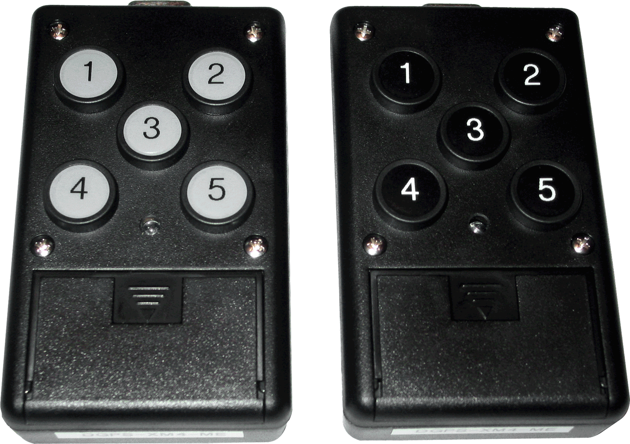
This device will store position, date, and time, plus it has five "event" buttons on the front. Each time a button is pushed, it stores a timestamped position with a label identifying which button you pushed. This allows you to quickly mark positions. For example, you could do population surveys while in a moving vehicle, or you could use it to mark noteworthy items while traveling.
5.14.2. Hacking the Hack: Build Your Own Data Logger
Being a geek, you probably read that section and thought "Ah, I could make one of those." Well of course you can! You can get the same effect by connecting your GPS unit to a laptop and logging everything that comes through. If you have a budget and an assigned project that requires a solid "solution," then the GPS data loggers are smaller, consume less power, and are less complicated. But it is more fun to make your own!
You could write a small program to directly open the serial port and log the GPS output, but that means that only one program at a time can get position information. The answer? Run gpsd [Hack #57] and then run a program to catch and log the position information that it reports.
Here is a program called gpslogger.pl that connects to the gpsd process and logs position, and a little bit more:
#!/usr/bin/perl

use 5.6.1;
use IO::Socket;
use Term::ReadKey;
use strict;

BEGIN { $|++ }; # autoflush STDOUT.

# Set parameters based on command line options, with defaults.
my $Rate = 1;
my $extended = shift( @ARGV ) || 0;
warn "extended: $extended
";
my $GPSD = shift( @ARGV ) || "localhost:2947";
# Connect to gpsd.
my $gps = IO::Socket::INET->new($GPSD)
 or die "Can't connect to gpsd at $GPSD: $!
";

while (1) {
 my $key;
 if ($extended) {
 warn "Enter an annotation, followed by
";
 $key = <>;
 chomp $key;
 } else {
 ReadMode 'cbreak';
 $key = ReadKey(-1);
 }
 # Tell gpsd we want position, altitude, date, and status.
 $gps->print("pads
");

 # Parse out the response. If the date is blank, gpsd needs
 # a second to catch up.
 my $location = <$gps>;
 my ($lat, $long, $alt, $date, $status) =
 ($location =~ /P=(.+?) (.+?),A=(.+?),D=(.+?),S=(.+?)/gos);

 next unless $status or $key;

 # Print a line of data to both STDOUT and STDERR, and wait.
 print $_ join("|", $lat, $long, $alt, $date, $key || "" ), "
"
 for ( *STDOUT, *STDERR );

 sleep( $Rate );
}
Start the program:
$ ./gpslogger.pl > annotation.txt

38.414367|-122.790083|87.100000|2004-10-23T23:25:33Z|A
38.414467|-122.789900|87.100000|2004-10-23T23:25:34Z|
38.414617|-122.789650|87.100000|2004-10-23T23:25:35Z|D
The output is pretty obvious: lat, long, elevation, and a timestamp, all delimited with the pipe symbol (|). But what is that character at the end of the line? That is the homebrew answer to the DGPS-XM4-ME's "event" buttons. When log_position.pl is running in the foreground and you press a key, it logs that key, the date and time, and your current location. Later, you can map the points with color codes for the different keys.
We can use the shapelib utilities [Hack #92] to create a script to convert this output to a shapefile that contains the tracklog, timestamp, and the buttons that you pushed:
#!/bin/sh
shpcreate events point
dbfcreate events -n elevation 5 0, -s timestamp 19, -s event 5
grep -v "^#" $1 |
awk -F| '{print "shpadd events " $1 " " $2 "; dbfadd events "" $3 "" "" $4 ""
"" $5 """}' |
sh
To run the script, use this command:
$ ./evt2shp.sh data.txt
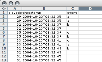
This will create a shapefile named events. This really refers to three files: events.shp, events.shx, and events.dbf. The file events.dbf is a dBase-format file that can be read in many different programs. The elevation, timestamp, and event fields are shown in Excel in Figure 5-32.
Figure 5-32. The dbf file from a shapefile
To see the contents of the dbf file from the command line, use the dbfdump utility from the shapelib utilities: dbfdump events.dbf. The latitude and longitude are stored in the shp and shx files and can be viewed by running the shpdump utility from shapelib: shpdump events.shp.
Our program logs "key presses," but if we salvage the keyboard encoder from a surplus keyboard, we can push the meaning of a "keyboard" well past the breaking point. There is a whole culture of people creating arcade game emulators using the Multiple Arcade Machine Emulator (MAME) software. These folks have created a full literature on using the electronics from old keyboards in new and entertaining ways as general data-input devices. Do a Google search on "hacking keyboard encoders" for more information.
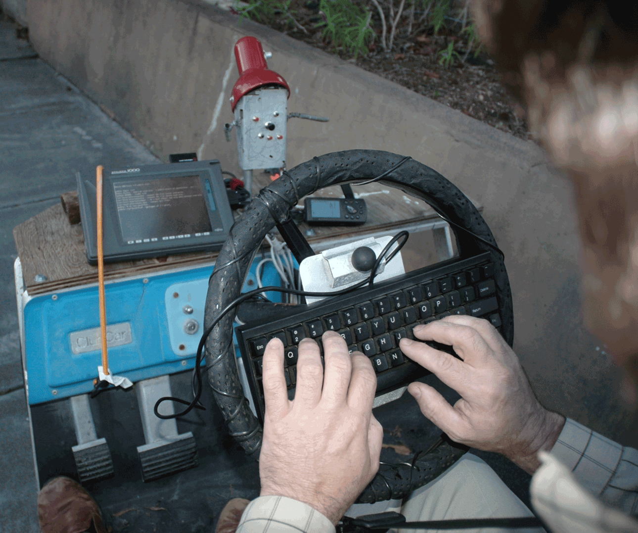
We can put this all together to create a compact and efficient portable tracklog-logging and event-logging system. In Figure 5-33, we see one such system. The computer is a Fujitsu Stylistic obtained at a surplus price. This is a 486-based tablet machine running the Pebble distribution of Linux. (Note: Pebble defaults to running getty on the serial port, so in order to get gpsd to work, you must comment out all lines in your /etc/inittab that refer to your serial port: /dev/ttyS0 on the Stylistic.) A Garmin GPS is connected via a serial cable. The Stylistic has an external keyboard connector, so we are using the "little man" keyboard. Pressing the buttons that make up his face generates keystrokes. (We could also use the Happy Hacker keyboard on the steering wheel if we wanted to be a tad less photogenic.)
Figure 5-33. A homebrewed geo-annotation device with custom "little man" keyboard
Using this setup, we can input GPS data and then map our results in terms of button pushes of the "left eye," "right eye," "nose," and "mouth parts 1 to 4." These work the same as the Track log Logger event buttons.
The gpslogger.pl program has one other trick: it can do extended annotations. If you start it with a command-line parameter, it will pause and wait for you to create an annotation that ends with the key:
$./gpslogger.pl yes > extended.txt

Enter an annotation, followed by
Fireman with dog
38.403367|-122.829733|55.100000|2004-10-26T01:13:24Z|Fireman with dog
The extended annotations can be converted to shapefiles with (almost) the same script as the previous one. The one change is to increase the size of the event field. In the line:
dbfcreate events -n elevation 5 0, -s timestamp 19, -s event 5
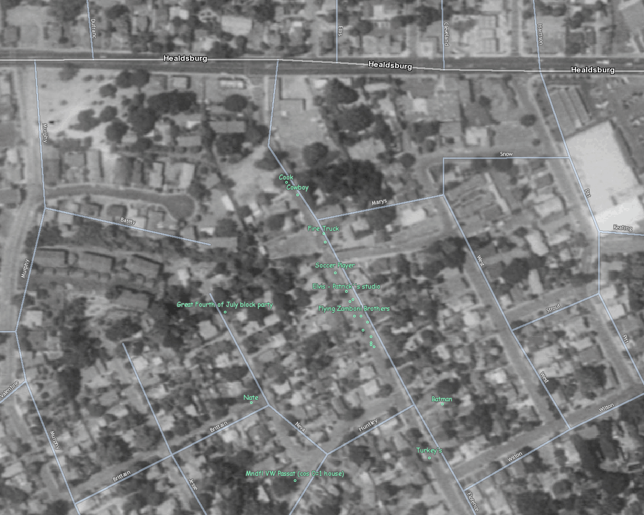
change -s event 5 to -s event 1024. This number (1024) needs to be larger than your longest annotation. In Figure 5-34, we see part of the results of extended geo-annotation. Note how the dots that mark annotations are slightly offset from the street.
Figure 5-34. Florence Avenue in downtown Sebastopol
This package, along with the saw blade at the base of the "keyboard," makes a perfect data-logging and geo-annotating solution, except for the possible difficulty in getting through airport security and the always possible risk of personal injury. What if we could use an ultra small computer? The Gumstix Waysmall computers (http://gumstix.com/) are tiny!
They are full Linux computers running on the Intel XScale PXA255 processor. They have two serial ports, one that you normally reserve to connect to the console in order to control the unit, and the second free and waiting to connect to your GPS unit. Add a 128 MB SDRAM card, and you should be able to store tracklogs at one-second intervals for over two weeks.
I have my Waysmall Computer and a GPS waiting in my workshop, ready to sacrifice all in support of my dreams of a capture device to support "Quantitative Psychogeography" as well as "Geospatially-aware narrative." As the unofficial motto of the Locative Media Lab runs, "Location: It's everywhere!"
Mapping Your Life
- Hacks 1-13
- Hack 1. Put a Map on It: Mapping Arbitrary Locations with Online Services
- Hack 2. Route Planning Online
- Hack 3. Map the Places Youve Visited
- Hack 4. Find Your House on an Aerial Photograph
- Hack 5. The Road Less Traveled by in MapQuest
- Hack 6. Make Route Maps Easier to Read
- Hack 7. Will the Kids Barf?
- Hack 8. Publish Maps of Your Photos on the Web
- Hack 9. Track the Friendly Skies with Sherlock
- Hack 10. Georeference Digital Photos
- Hack 11. How Far? How Fast? Geo-Enabling Your Spreadsheet
- Hack 12. Create a Distance Grid in Excel
- Hack 13. Add Maps to Excel Spreadsheets with MapPoint
Mapping Your Neighborhood
- Hacks 14-21
- Hack 14. Make Free Maps of the United States Online
- Hack 15. Zoom Right In on Your Neighborhood
- Hack 16. Who Are the Neighbors Voting For?
- Hack 17. Map Nearby Wi-Fi Hotspots
- Hack 18. Why You Cant Watch Broadcast TV
- Hack 19. Analyze Elevation Profiles for Wireless Community Networks
- Hack 20. Make 3-D Raytraced Terrain Models
- Hack 21. Map Health Code Violations with RDFMapper
Mapping Your World
- Hacks 22-34
- Hack 22. Digging to China
- Hack 23. Explore David Rumseys Historical Maps
- Hack 24. Explore a 3-D Model of the Entire World
- Hack 25. Work with Multiple Lat/Long Formats
- Hack 26. Work with Different Coordinate Systems
- Hack 27. Calculate the Distance Between Points on the Earths Surface
- Hack 28. Experiment with Different Cartographic Projections
- Hack 29. Plot Arbitrary Points on a World Map
- Hack 30. Plot a Great Circle on a Flat Map
- Hack 31. Plot Dymaxion Maps in Perl
- Hack 32. Hack on Base Maps in Your Favorite Image Editor
- Hack 33. Georeference an Arbitrary Tourist Map
- Hack 34. Map Other Planets
Mapping (on) the Web
- Hacks 35-46
- Hack 35. Search Local, Find Global
- Hack 36. Shorten Online Map URLs
- Hack 37. Tweak the Look and Feel of Web Maps
- Hack 38. Add Location to Weblogs and RSS Feeds
- Hack 39. View Your Photo Thumbnails on a Flash Map
- Hack 40. Plot Points on a Spinning Globe Applet
- Hack 41. Plot Points on an Interactive Map Using DHTML
- Hack 42. Map Your Tracklogs on the Web
- Hack 43. Map Earthquakes in (Nearly) Real Time
- Hack 44. Plot Statistics Against Shapes
- Hack 45. Extract a Spatial Model from Wikipedia
- Hack 46. Map Global Weather Conditions
Mapping with Gadgets
- Hacks 47-63
- How GPS Works
- Hack 47. Get Maps on Your Mobile Phone
- Hack 48. Accessorize Your GPS
- Hack 49. Get Your Tracklogs in Windows or Linux
- Hack 50. The Serial Port to USB Conundrum
- Hack 51. Speak in Geotongues: GPSBabel to the Rescue
- Hack 52. Show Your Waypoints on Aerial Photos with Terrabrowser
- Hack 53. Visualize Your Tracks in Three Dimensions
- Hack 54. Create Your Own Maps for a Garmin GPS
- Hack 55. Use Your Track Memory as a GPS Base Map
- Hack 56. Animate Your Tracklogs
- Hack 57. Connect to Your GPS from Multiple Applications
- Hack 58. Dont Lose Your Tracklogs!
- Hack 59. Geocode Your Voice Recordings and Other Media
- Hack 60. Improve the Accuracy of Your GPS with Differential GPS
- Hack 61. Build a Map of Local GSM Cells
- Hack 62. Build a Car Computer
- Hack 63. Build Your Own Car Navigation System with GpsDrive
Mapping on Your Desktop
- Hacks 64-77
- Hack 64. Mapping Local Areas of Interest with Quantum GIS
- Hack 65. Extract Data from Maps with Manifold
- Hack 66. Java-Based Desktop Mapping with Openmap
- Hack 67. Seamless Data Download from the USGS
- Hack 68. Convert Geospatial Data Between Different Formats
- Hack 69. Find Your Way Around GRASS
- Hack 70. Import Your GPS Waypoints and Tracklogs into GRASS
- Hack 71. Turn Your Tracklogs into ESRI Shapefiles
- Hack 72. Add Relief to Your Topographic Maps
- Hack 73. Make Your Own Contour Maps
- Hack 74. Plot Wireless Network Viewsheds with GRASS
- Hack 75. Share Your GRASS Maps with the World
- Hack 76. Explore the Effects of Global Warming
- Conclusion
- Hack 77. Become a GRASS Ninja
Names and Places
- Hacks 78-86
- Hack 78. What to Do if Your Government Is Hoarding Geographic Data
- Hack 79. Geocode a U.S. Street Address
- Hack 80. Automatically Geocode U.S. Addresses
- Hack 81. Clean Up U.S. Addresses
- Hack 82. Find Nearby Things Using U.S. ZIP Codes
- Hack 83. Map Numerical Data the Easy Way
- Hack 84. Build a Free World Gazetteer
- Hack 85. Geocode U.S. Locations with the GNIS
- Hack 86. Track a Package Across the U.S.
Building the Geospatial Web
- Hacks 87-92
- Hack 87. Build a Spatially Indexed Data Store
- Hack 88. Load Your Waypoints into a Spatial Database
- Hack 89. Publish Your Geodata to the Web with GeoServer
- Hack 90. Crawl the Geospatial Web with RedSpider
- Hack 91. Build Interactive Web-Based Map Applications
- Hack 92. Map Wardriving (and other!) Data with MapServer
Mapping with Other People
- Hacks 93-100
- Hack 93. Node Runner
- Hack 94. Geo-Warchalking with 2-D Barcodes
- Hack 95. Model Interactive Spaces
- Hack 96. Share Geo-Photos on the Web
- Hack 97. Set Up an OpenGuide for Your Hometown
- Hack 98. Give Your Great-Great-Grandfather a GPS
- Hack 99. Map Your Friend-of-a-Friend Network
- Hack 100. Map Imaginary Places
EAN: 2147483647
Pages: 172
- Creating Indexes for Fast Data Retrieval
- Performing Multiple-table Queries and Creating SQL Data Views
- Working with SQL JOIN Statements and Other Multiple-table Queries
- Understanding Transaction Isolation Levels and Concurrent Processing
- Writing External Applications to Query and Manipulate Database Data
