How GPS Works
The Global Positioning System, or GPS for short, is a marvel of modern technology. The 24 NAVSTAR satellites that make up the orbital component of the Global Positioning System were launched by the U.S. Air Force, starting in 1978. The satellites orbit Earth about 650 kilometers above its surface and are staggered in such a way that three or four should be overhead, anywhere on Earth, at any time. Each satellite carries an atomic clock on board, which it uses to transmit the precise time over a microwave signal back to receivers on Earth, along with a set of 3-D position data, called an ephemeris, which describes the satellite's location in the sky.
According to Einstein's Special Theory of Relativity, a radio signal should travel at a constant speed in a vacuum. Therefore, in principle, if you know what time a radio signal was transmitted and where it was transmitted from, then you can deduce how far away the transmitter is from how long it took the signal to arrive. However, just because you know how far a radio signal traveled doesn't mean you know which direction it came from. This means that, given a signal from a single satellite, we can only estimate our position to be within the radius of a circle of that distance around the satellite in question.
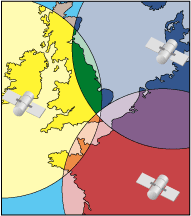
If we attempt to listen to more than one satellite at a time, we can build up a series of overlapping circles, as shown in Figure 5-1. Each circle progressively narrows the portion of Earth's surface that we can be in, based on the radio signals we're receiving. In principle, three circles are sufficient to establish a two-dimensional fix on our own position, and four are enough to establish a three-dimensional fix. Ultimately, with enough satellite signals, we can narrow down the estimate of our position on Earth's surface to within as little as five meterswhich is one-eightieth of one percent of the planet's circumference! Not bad at all.
Figure 5-1. Triangulation via GPS satellite signals
In practice, though, GPS reception varies widely with the time of day, the state of Earth's ionosphere, and particularly with nearby terrain. Hills, buildings, and trees can all cut GPS reception to nothing, so your results may vary. GPS reception doesn't work at all indoors (except sometimes near windows) or underwater.
Other global positioning systems are in use as well. The U.S. maintains a ground-based maritime navigation system called LORAN-C, which operates along similar principles. Russia still maintains its own satellite-based GPS, known as GLONASS. More recently, other nations, including the European Union and China, are working together to field their own satellite-based global positioning system, called Galileo, which they hope to have online by 2007.
|

5.2.1. Leave your own breadcrumbs: tracklogs and waypoints
Most handheld GPS units provide an easy way to save a marker to your current position. These are called waypoints, and they are great at allowing you to capture your own experiences. If you press and hold the "mark" button, the GPS will display a screen allowing you to name the waypoint. A tracklog is a series of position points that shows where you were. A tracklog may also contain the time and the elevation at that point. In contrast to waypoints, which must be set manually, GPS receivers will typically record tracklogs automatically as you move about.
You can read waypoints and tracklogs into your computer with Garnix [Hack #49] , GPSBabel [Hack #51], or many other programs. There are too many formats for storing waypoint and tracklog data! Fortunately GPSBabel can convert just about any of them to any other. We strongly recommend the use of GPX for storing tracklogs and waypoints. GPX is an XML format that is designed to facilitate the exchange of GPS data between applications and on the Web. It's supported by lots of applications, including many of those described in this book. You can find out more about GPX at http://topografix.com/gpx.
Since a tracklog is just a list of points, you can create or re-create a tracklog from a paper map or other record of a trip. See [Hack #98] for an example of creating a tracklog from the diary of an Oregon Trail emigrant.
Once you have a tracklog, you can display it over an aerial photo with Wissenbach 3D, 3Dem, or Terra Browser. You can also create an animation of your journey [Hack #56] . These are tools that treat the tracklog as a line.
The tool provided at http://www.mappinghacks.com/projects/linkmedia/ [Hack #59] will take a tracklog and a list of timestamps, perhaps representing the times at which you took pictures, and tell you where you were at those times. It will also tell you how fast you were going, and what direction you were going (your heading) based on that tracklog.
5.2.1.1 Understanding tracklog options
Different GPS units store different numbers of track points. The basic Garmin Etrex stores 1,536 points, while the Etrex legend can hold 10,000. The Earthmate BlueLogger has "over 50,000." How many points is enough? When I bought my Garmin IIIplus, I was sure that its 1.44 MB of RAM and 1,900 track points would be enough for me!
I was wrong. See [Hack #58] for a discussion of tracklog loggers that can effectively allow you to store an unlimited number of track points.
Tracklogs are like electronic breadcrumbs. You can usually select how often you want to drop a crumb. Because the bag is a fixed size, you will run out of crumbs more quickly if you drop crumbs more frequently. If you have a basic GPS with 1,500 or so track points, then saving a track point every second will fill your memory in less then 30 minutes. And even 10,000 points would last less than three hours! The default GPS settings are a reasonable compromise, but if you are planning to do interesting things with your tracklogs, you should experiment before you set out on a trip. As the owner of a camera store once told me, "You `going on a trip' guys scare me."
5.2.1.2 What about precision?
You often see coordinates displayed with more precision than is strictly relevant, and GPS units can display position with more precision than their accuracy. Precision measures how many digits your GPS receiver can approximate its results to, and accuracy measures how close this approximation comes to the true results. Thus, a value of 38.432212 is more precise than 38.43. But that doesn't mean it is more accurate.
O'Reilly Media's headquarters is located at latitude = 38.411269, longitude = -122.841256. What does that mean? If we go back to our knowledge of the meter, we can develop a rule of thumb about digits of precision in terms of geographical position. The original definition of a meter was 1/10,000,000th (one ten-millionth) of the distance from the equator to the North Pole by way of Paris. So 1 meter is equal to 90 degrees divided by 10,000,000or 0.000009 degrees. A one-digit difference in the 6th decimal place is the distance from 0.000000 to 0.000001 degrees, which is equal to 1/9th of a meter. This is equal to about 11 centimeters, or 4.4 inches. Your GPS receiver is not accurate to 4 inches!
Specifying coordinates to four decimal places gives you approximately 10-meter precision. That is close enough for normal automobile navigation, and your GPS receiver isn't really that accurate either. I like to store six digits, because those last digits obscure any rounding errors that might creep in. Here is a table of approximate distances by decimal place:
|
Degrees north or south |
Equivalent metric/English distances |
|---|---|
|
1 degree |
111 km (69 mi) |
|
1/10 of a degree |
11.1 km (6.9 mi) |
|
1/100 of a degree |
1.11 km (0.69 mi) |
|
1/1,000 of a degree |
111 m (364 ft) |
|
1/10,000 of a degree |
11.1 m (36.4 ft) |
|
1/100,000 of a degree |
1.11 m (3.64 ft) |
|
1/1,000,000 of a degree |
11 cm (4.4 in) |
The normal practice is to match your precision and your accuracy, but you can play games with that convention. The U.S. Census Bureau publishes their TIGER/Line data with six degrees of precision. When you get out in the field, the data is often several hundred feet off, implying that at best it is accurate to about four decimal places. But the TIGER data uses that false precision to indicate the relative positions of things.
For example, when you give road directions based on your odometer, you are limited to a precision of 1/10th of a mile, which is the limit of your measuring tool. But if you see three houses within the same tenth of a mile, say 2.1 miles from a landmark, you could indicate their relative positions by adding a false decimal of accuracy and say that the first house was at 2.1 miles, the second at 2.13, and the third at 2.16.
You want to find a balance among precision, accuracy, and usefulness!
Mapping Your Life
- Hacks 1-13
- Hack 1. Put a Map on It: Mapping Arbitrary Locations with Online Services
- Hack 2. Route Planning Online
- Hack 3. Map the Places Youve Visited
- Hack 4. Find Your House on an Aerial Photograph
- Hack 5. The Road Less Traveled by in MapQuest
- Hack 6. Make Route Maps Easier to Read
- Hack 7. Will the Kids Barf?
- Hack 8. Publish Maps of Your Photos on the Web
- Hack 9. Track the Friendly Skies with Sherlock
- Hack 10. Georeference Digital Photos
- Hack 11. How Far? How Fast? Geo-Enabling Your Spreadsheet
- Hack 12. Create a Distance Grid in Excel
- Hack 13. Add Maps to Excel Spreadsheets with MapPoint
Mapping Your Neighborhood
- Hacks 14-21
- Hack 14. Make Free Maps of the United States Online
- Hack 15. Zoom Right In on Your Neighborhood
- Hack 16. Who Are the Neighbors Voting For?
- Hack 17. Map Nearby Wi-Fi Hotspots
- Hack 18. Why You Cant Watch Broadcast TV
- Hack 19. Analyze Elevation Profiles for Wireless Community Networks
- Hack 20. Make 3-D Raytraced Terrain Models
- Hack 21. Map Health Code Violations with RDFMapper
Mapping Your World
- Hacks 22-34
- Hack 22. Digging to China
- Hack 23. Explore David Rumseys Historical Maps
- Hack 24. Explore a 3-D Model of the Entire World
- Hack 25. Work with Multiple Lat/Long Formats
- Hack 26. Work with Different Coordinate Systems
- Hack 27. Calculate the Distance Between Points on the Earths Surface
- Hack 28. Experiment with Different Cartographic Projections
- Hack 29. Plot Arbitrary Points on a World Map
- Hack 30. Plot a Great Circle on a Flat Map
- Hack 31. Plot Dymaxion Maps in Perl
- Hack 32. Hack on Base Maps in Your Favorite Image Editor
- Hack 33. Georeference an Arbitrary Tourist Map
- Hack 34. Map Other Planets
Mapping (on) the Web
- Hacks 35-46
- Hack 35. Search Local, Find Global
- Hack 36. Shorten Online Map URLs
- Hack 37. Tweak the Look and Feel of Web Maps
- Hack 38. Add Location to Weblogs and RSS Feeds
- Hack 39. View Your Photo Thumbnails on a Flash Map
- Hack 40. Plot Points on a Spinning Globe Applet
- Hack 41. Plot Points on an Interactive Map Using DHTML
- Hack 42. Map Your Tracklogs on the Web
- Hack 43. Map Earthquakes in (Nearly) Real Time
- Hack 44. Plot Statistics Against Shapes
- Hack 45. Extract a Spatial Model from Wikipedia
- Hack 46. Map Global Weather Conditions
Mapping with Gadgets
- Hacks 47-63
- How GPS Works
- Hack 47. Get Maps on Your Mobile Phone
- Hack 48. Accessorize Your GPS
- Hack 49. Get Your Tracklogs in Windows or Linux
- Hack 50. The Serial Port to USB Conundrum
- Hack 51. Speak in Geotongues: GPSBabel to the Rescue
- Hack 52. Show Your Waypoints on Aerial Photos with Terrabrowser
- Hack 53. Visualize Your Tracks in Three Dimensions
- Hack 54. Create Your Own Maps for a Garmin GPS
- Hack 55. Use Your Track Memory as a GPS Base Map
- Hack 56. Animate Your Tracklogs
- Hack 57. Connect to Your GPS from Multiple Applications
- Hack 58. Dont Lose Your Tracklogs!
- Hack 59. Geocode Your Voice Recordings and Other Media
- Hack 60. Improve the Accuracy of Your GPS with Differential GPS
- Hack 61. Build a Map of Local GSM Cells
- Hack 62. Build a Car Computer
- Hack 63. Build Your Own Car Navigation System with GpsDrive
Mapping on Your Desktop
- Hacks 64-77
- Hack 64. Mapping Local Areas of Interest with Quantum GIS
- Hack 65. Extract Data from Maps with Manifold
- Hack 66. Java-Based Desktop Mapping with Openmap
- Hack 67. Seamless Data Download from the USGS
- Hack 68. Convert Geospatial Data Between Different Formats
- Hack 69. Find Your Way Around GRASS
- Hack 70. Import Your GPS Waypoints and Tracklogs into GRASS
- Hack 71. Turn Your Tracklogs into ESRI Shapefiles
- Hack 72. Add Relief to Your Topographic Maps
- Hack 73. Make Your Own Contour Maps
- Hack 74. Plot Wireless Network Viewsheds with GRASS
- Hack 75. Share Your GRASS Maps with the World
- Hack 76. Explore the Effects of Global Warming
- Conclusion
- Hack 77. Become a GRASS Ninja
Names and Places
- Hacks 78-86
- Hack 78. What to Do if Your Government Is Hoarding Geographic Data
- Hack 79. Geocode a U.S. Street Address
- Hack 80. Automatically Geocode U.S. Addresses
- Hack 81. Clean Up U.S. Addresses
- Hack 82. Find Nearby Things Using U.S. ZIP Codes
- Hack 83. Map Numerical Data the Easy Way
- Hack 84. Build a Free World Gazetteer
- Hack 85. Geocode U.S. Locations with the GNIS
- Hack 86. Track a Package Across the U.S.
Building the Geospatial Web
- Hacks 87-92
- Hack 87. Build a Spatially Indexed Data Store
- Hack 88. Load Your Waypoints into a Spatial Database
- Hack 89. Publish Your Geodata to the Web with GeoServer
- Hack 90. Crawl the Geospatial Web with RedSpider
- Hack 91. Build Interactive Web-Based Map Applications
- Hack 92. Map Wardriving (and other!) Data with MapServer
Mapping with Other People
- Hacks 93-100
- Hack 93. Node Runner
- Hack 94. Geo-Warchalking with 2-D Barcodes
- Hack 95. Model Interactive Spaces
- Hack 96. Share Geo-Photos on the Web
- Hack 97. Set Up an OpenGuide for Your Hometown
- Hack 98. Give Your Great-Great-Grandfather a GPS
- Hack 99. Map Your Friend-of-a-Friend Network
- Hack 100. Map Imaginary Places
EAN: 2147483647
Pages: 172
