Hack 5. The Road Less Traveled by in MapQuest


The specified route may get you where you want to be, but what about that other road?
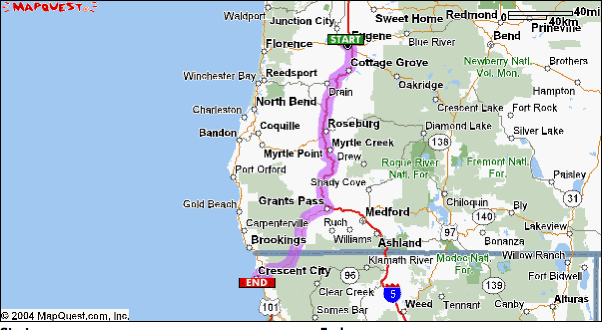
The interstates are fast and clean, but the Blue Highways are more than a routing choice. The motto of the Blue Line fan is "There is more than one way to get there." One morning I happened to stagger into life at 9:00 A.M., fretting about the coming day. I was in Portland, Oregon, at the O'Reilly Open Source Convention and wanted to get home to Sebastopol, California. The obvious and "simple" route is 656 miles down I-5, past Sebastopol, then a swoop up and around the San Francisco Bay and up 101.
Frankly, it is one of the prettier interstate drives around, but it is still an interstate drive. My car mates were lobbying hard for the purely scenic route along Highway 101. To make things a tad more complicated, we had to pick up yet another passenger in Eugene, Oregon. How much pain and time was that Blue Highway scenery going to cost me? I needed a way to quantify the tedium of the longer journey.
Everyone uses MapQuest to prepare monolithic routes, a single routing that describes the whole trip. I wanted to split that into segments and compare the time and distance of each segment. If you have connectivity, you can create multiple views of the same journey in MapQuest, or use the same techniques in any mapping service that provides directions. As an aside, the connectivity in Lithia Park in Ashland, Oregon, is stellar. The drive from Portland to Ashland is easy, so it is convenient to stop in Ashland to download a bunch of code to play with on the rest of the trip.
1.6.1. Get the Right Scale
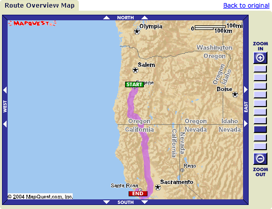
Picking alternative routes requires that we can see them! Since this trip is so long, we can't get enough detail to compare the I-5 and coastal alternatives on one map. The map in Figure 1-7 is useless for alternate route determination! In order to compare alternatives, we need to split our journey into at least two more detailed parts.
Figure 1-7. The scale is wrong, and no alternatives appear in the overview map
Here we can use the "Open in New Window" trick of most browsers. Navigate through MapQuest to a map that shows your complete trip and then right-click (Ctrl-click on the Mac) on the "+" sign of the Zoom tool that is along the right side of the map. In most browsers, this will open a right-click context menu that includes the option to open the link in a new window.
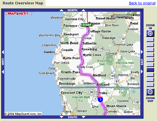
That's more like it! In Figure 1-8, we can see the coastal route, and we have enough context to know what questions we want to ask next. One key to effective use of electronic maps is to zoom in close enough to see the important details, yet far enough out so as not to get lost in the detail. It is a balancing act for each exploration.
Figure 1-8. Oregon from Eugene down
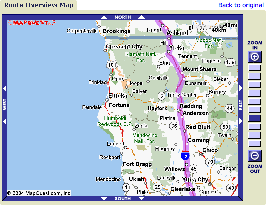
Now zoom in so that you have two identical views of the same map. Next scroll the original, less detailed map down by clicking on the arrows on the bottom (south) side of the map. The idea is to have windows of each segment of the trip with enough overlap so you can mentally stitch the maps together (see Figure 1-9).
Figure 1-9. Northern California, showing the route down I-5
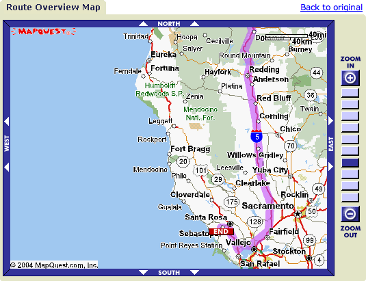
In this case, I need a third map to capture that important area south of Mendocino! So I repeat the process of opening a new window to get three browser windows that, between them, cover the whole trip. In this case, I right-click on the arrows pointing south to open a new window that includes Sebastopol (Figure 1-10).
Figure 1-10. The rest of the California leg of the trip
1.6.2. There's More Than One Way to Get There!
We want to explore the maps to get ideas about what we want to experience. This is the fun part of the process! First consider your constraintsin our case, we need to pick up Gene in Eugeneand then look at what is possible. Eugene is on I-5, so how would we get to 101? Looking at the Oregon portion of the trip, there are two seemingly reasonable ways to get to Highway 101 on the coast. We can go directly to Florence, or head down Highway 5 to Grant's Pass and then take the little red road to Crescent City in the extreme northwest corner of California.
So let's compare these two segments. Open yet another MapQuest window by right-clicking on "New Directions," and let's see what MapQuest has to offer about a trip from Eugene, Oregon, to Crescent City, California (Figure 1-11).
Figure 1-11. Directions from Eugene, OR, to Crescent City, CA
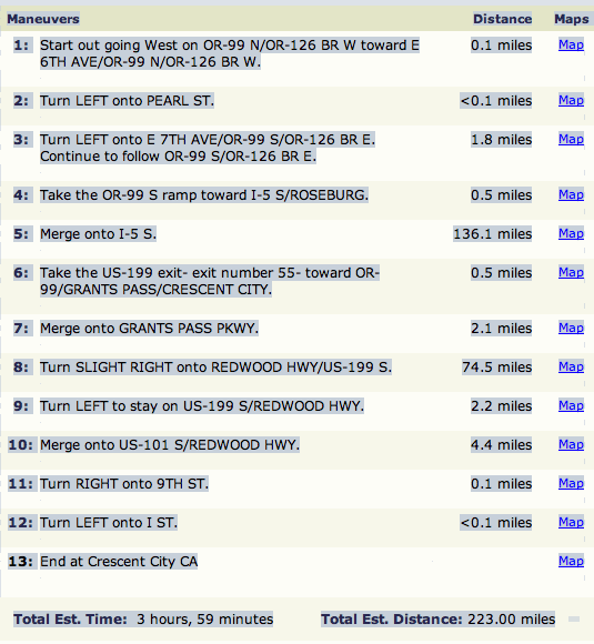
Interesting! MapQuest picks the interstate for the majority of the trip. The alternative from Eugene images/ent/U2192.GIF border=0> Florence
images/ent/U2192.GIF border=0> Crescent City is ignored.
1.6.3. Using Estimated Time
A note on Estimated Time and using trip segments to get an idea of the heinousness of a route: everyone has a different idea of how long a trip will take, and none of the estimates are "correct." In this case, MapQuest is suggesting an average speed of about 56 mph for the whole leg (223 miles divided by 239 minutes times 60 minutes per hour = 56 miles per hour). Breaking that down, it is 58 mph for the I-5 portion.
I know that I can drive faster on the interstate, but does that mean I'll get there sooner? Who knows! I have a new camera and I'm snap-happy. Maybe we'll stop every 10 miles on either route. Perhaps there is an interesting museum right off the interstate. MapQuest can't tell us what we'll do, but using their idea of travel time and average speed will help us out. See [Hack #7] to get another trick to use with MapQuest.
1.6.4. Tricking MapQuest with Multiple Routes
MapQuest always gives us the "best" route, where "best" is set by their programmers. If we want to compare different routes, we need to break up our original trip into sections so that MapQuest is forced to give us our preferred route, and then we need to add up the segments.
For example, when we asked for the route from Eugene to Crescent City, MapQuest routed us through Grants Pass. The service won't give us a route from Eugene to Florence, on the coast, and then down to Crescent City. But MapQuest will give us the route from Eugene to Florence, if we ask nicely, and then the route from Florence to Crescent City.
So how do the different options compare? The times and distances for these two options are shown in Figure 1-12.
Figure 1-12. Comparing I-5 with the coastal route
The bottom line? The coast route is only 22 miles longer. No problem. It is also nearly an hour and a half longer, and the average speed is 11 mph lower. Ultimately, we elected to go straight down I-5, and we didn't get home until 4:30 A.M., so I'm just as happy that we managed to avoid driving until 6:00 A.M. both going up and coming home.
Mapping Your Life
- Hacks 1-13
- Hack 1. Put a Map on It: Mapping Arbitrary Locations with Online Services
- Hack 2. Route Planning Online
- Hack 3. Map the Places Youve Visited
- Hack 4. Find Your House on an Aerial Photograph
- Hack 5. The Road Less Traveled by in MapQuest
- Hack 6. Make Route Maps Easier to Read
- Hack 7. Will the Kids Barf?
- Hack 8. Publish Maps of Your Photos on the Web
- Hack 9. Track the Friendly Skies with Sherlock
- Hack 10. Georeference Digital Photos
- Hack 11. How Far? How Fast? Geo-Enabling Your Spreadsheet
- Hack 12. Create a Distance Grid in Excel
- Hack 13. Add Maps to Excel Spreadsheets with MapPoint
Mapping Your Neighborhood
- Hacks 14-21
- Hack 14. Make Free Maps of the United States Online
- Hack 15. Zoom Right In on Your Neighborhood
- Hack 16. Who Are the Neighbors Voting For?
- Hack 17. Map Nearby Wi-Fi Hotspots
- Hack 18. Why You Cant Watch Broadcast TV
- Hack 19. Analyze Elevation Profiles for Wireless Community Networks
- Hack 20. Make 3-D Raytraced Terrain Models
- Hack 21. Map Health Code Violations with RDFMapper
Mapping Your World
- Hacks 22-34
- Hack 22. Digging to China
- Hack 23. Explore David Rumseys Historical Maps
- Hack 24. Explore a 3-D Model of the Entire World
- Hack 25. Work with Multiple Lat/Long Formats
- Hack 26. Work with Different Coordinate Systems
- Hack 27. Calculate the Distance Between Points on the Earths Surface
- Hack 28. Experiment with Different Cartographic Projections
- Hack 29. Plot Arbitrary Points on a World Map
- Hack 30. Plot a Great Circle on a Flat Map
- Hack 31. Plot Dymaxion Maps in Perl
- Hack 32. Hack on Base Maps in Your Favorite Image Editor
- Hack 33. Georeference an Arbitrary Tourist Map
- Hack 34. Map Other Planets
Mapping (on) the Web
- Hacks 35-46
- Hack 35. Search Local, Find Global
- Hack 36. Shorten Online Map URLs
- Hack 37. Tweak the Look and Feel of Web Maps
- Hack 38. Add Location to Weblogs and RSS Feeds
- Hack 39. View Your Photo Thumbnails on a Flash Map
- Hack 40. Plot Points on a Spinning Globe Applet
- Hack 41. Plot Points on an Interactive Map Using DHTML
- Hack 42. Map Your Tracklogs on the Web
- Hack 43. Map Earthquakes in (Nearly) Real Time
- Hack 44. Plot Statistics Against Shapes
- Hack 45. Extract a Spatial Model from Wikipedia
- Hack 46. Map Global Weather Conditions
Mapping with Gadgets
- Hacks 47-63
- How GPS Works
- Hack 47. Get Maps on Your Mobile Phone
- Hack 48. Accessorize Your GPS
- Hack 49. Get Your Tracklogs in Windows or Linux
- Hack 50. The Serial Port to USB Conundrum
- Hack 51. Speak in Geotongues: GPSBabel to the Rescue
- Hack 52. Show Your Waypoints on Aerial Photos with Terrabrowser
- Hack 53. Visualize Your Tracks in Three Dimensions
- Hack 54. Create Your Own Maps for a Garmin GPS
- Hack 55. Use Your Track Memory as a GPS Base Map
- Hack 56. Animate Your Tracklogs
- Hack 57. Connect to Your GPS from Multiple Applications
- Hack 58. Dont Lose Your Tracklogs!
- Hack 59. Geocode Your Voice Recordings and Other Media
- Hack 60. Improve the Accuracy of Your GPS with Differential GPS
- Hack 61. Build a Map of Local GSM Cells
- Hack 62. Build a Car Computer
- Hack 63. Build Your Own Car Navigation System with GpsDrive
Mapping on Your Desktop
- Hacks 64-77
- Hack 64. Mapping Local Areas of Interest with Quantum GIS
- Hack 65. Extract Data from Maps with Manifold
- Hack 66. Java-Based Desktop Mapping with Openmap
- Hack 67. Seamless Data Download from the USGS
- Hack 68. Convert Geospatial Data Between Different Formats
- Hack 69. Find Your Way Around GRASS
- Hack 70. Import Your GPS Waypoints and Tracklogs into GRASS
- Hack 71. Turn Your Tracklogs into ESRI Shapefiles
- Hack 72. Add Relief to Your Topographic Maps
- Hack 73. Make Your Own Contour Maps
- Hack 74. Plot Wireless Network Viewsheds with GRASS
- Hack 75. Share Your GRASS Maps with the World
- Hack 76. Explore the Effects of Global Warming
- Conclusion
- Hack 77. Become a GRASS Ninja
Names and Places
- Hacks 78-86
- Hack 78. What to Do if Your Government Is Hoarding Geographic Data
- Hack 79. Geocode a U.S. Street Address
- Hack 80. Automatically Geocode U.S. Addresses
- Hack 81. Clean Up U.S. Addresses
- Hack 82. Find Nearby Things Using U.S. ZIP Codes
- Hack 83. Map Numerical Data the Easy Way
- Hack 84. Build a Free World Gazetteer
- Hack 85. Geocode U.S. Locations with the GNIS
- Hack 86. Track a Package Across the U.S.
Building the Geospatial Web
- Hacks 87-92
- Hack 87. Build a Spatially Indexed Data Store
- Hack 88. Load Your Waypoints into a Spatial Database
- Hack 89. Publish Your Geodata to the Web with GeoServer
- Hack 90. Crawl the Geospatial Web with RedSpider
- Hack 91. Build Interactive Web-Based Map Applications
- Hack 92. Map Wardriving (and other!) Data with MapServer
Mapping with Other People
- Hacks 93-100
- Hack 93. Node Runner
- Hack 94. Geo-Warchalking with 2-D Barcodes
- Hack 95. Model Interactive Spaces
- Hack 96. Share Geo-Photos on the Web
- Hack 97. Set Up an OpenGuide for Your Hometown
- Hack 98. Give Your Great-Great-Grandfather a GPS
- Hack 99. Map Your Friend-of-a-Friend Network
- Hack 100. Map Imaginary Places
EAN: 2147483647
Pages: 172
