Hack 94. Geo-Warchalking with 2-D Barcodes


Tagging physical spaces with readable messages for humans has many physical and digital manifestations. What about geotagging for machines?
Geo-warchalking was originally a simple idea of people marking postcodes and latitude/longitude pairs around the urban environment in chalk, similar to the Wi-Fi markings based on symbols chalked by traveling hobos, making the invisible visible.
Written symbols in the world are still hard to get in and out of an electronic location system. You don't really want to be typing in numbers to eight decimal places, or triple-tapping postcodes. Human-understandable is not necessarily machine-readable.
So how can we make reading and writing spatial annotations from handheld devices easy and automatic? Until RFID tags become available in spray cans, anyone can sticker the city...with barcodes.
9.3.1. Big in Japan
Especially in Japan, many modern mobile phones read 2-D barcodes, in a standard format, using the on-phone camera. These barcodes include a phone number and a URL or email address. These barcodes have infiltrated the business world. People print them on their paper business cards, and advertisements often have a barcode link.
But we want to store other data. We want latitude and longitude. We want places. We want lots of things: we want to barcode tables, chairs, everything! How can we create all these specifications to describe all these things?
Many of them exist already, in the form of RDF schemas. [Hack #95] outlines some of the basic options for describing spaces, and things that relate to them, in RDF. There are schemas, or ontologies, to describe positioning (geo), places (spacenamespace, locative) and even people and homepages (FOAF). If you want to describe something else, it's not that hard to make and publish your own special-purpose schema.
Geo-warchalkers propose to use the same standard for barcode encoding as used in Japan: QR Code. It's scalable (up to about 4 KB), it's in the public domain, it handles odd characters (such as Japanese scripts), and it copes pretty well with being readable when the barcode is damaged.
9.3.2. Making 2-D Geobarcodes
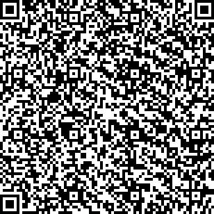
There's a selection of software for generating QR barcodes online, most of it Windows payware. The free web service at http://nfg.2y.net/system/qrcodegen.php allows you to type into a text area, and then generates a barcode from your input. Figure 9-2 shows a chunk of geospatial RDF (the example from the geo workspace at http://www.w3.org/2003/01/geo/) encoded as a QR code:
Figure 9-2. An RDF geo-annotation rendered as a 2-D barcode.

 55.701
 12.552
Now, it might be worth being a bit pragmatic and not including the RDF blurb at the beginning (i.e., just encoding the actual geo packet). This is the most compressed representation of a WGS84 latitude and longitude in RDF, and its barcode is shown in Figure 9-3:
Figure 9-3. A minimal geobarcode

The other thing to add is a human-readable indication of what you're encodingi.e., the namespace: geo, locative, or FOAF. This makes it possible for you to work out what kind of thing you're scanning or looking for.
And just to prove how crazy this can get, Figure 9-4 shows the description section of my FOAF file.
Figure 9-4. A FOAF file encoded with a geobarcode
If you include all my email aliases, it gets to a point where I don't think camera phones can cope.
So, let's annotate the planet! What do we need next?
- A simple standard proposal
- Free open reader and writer software, both for PCs and phones
- Crazy geo-pirate graffiti gangs
9.3.3. Why-Not Questions
9.3.3.1 Why not use RFID?
It's too expensive, and not generally available. All you need with barcodes is a printer.
9.3.3.2 Why not just use a pointer or a URI?
This isn't just for connected devices such as camera phones. Your digital camera might use a geobarcode to geoposition your photo. Your GPS could learn more about places and things via barcodes. Encoding the information within the barcode makes the system more open-ended and hackable.
9.3.3.3 Why not use n3 triples?
I thought more software and hardware would understand some form of XML, rather than n3. (I have never seen an n3-reading app outside of RDF testbeds.)
9.3.3.4 Why not zip/gzip the data first?
This is a pretty good point, which should be investigated. I'm worried that this causes more complexity, and things to go wrong. I want to see if doing this makes the barcodes less fault-tolerant.
9.3.4. See Also
- [Hack #99]
- [Hack #95]
- [Hack #97]
Chris Heathcote
Mapping Your Life
- Hacks 1-13
- Hack 1. Put a Map on It: Mapping Arbitrary Locations with Online Services
- Hack 2. Route Planning Online
- Hack 3. Map the Places Youve Visited
- Hack 4. Find Your House on an Aerial Photograph
- Hack 5. The Road Less Traveled by in MapQuest
- Hack 6. Make Route Maps Easier to Read
- Hack 7. Will the Kids Barf?
- Hack 8. Publish Maps of Your Photos on the Web
- Hack 9. Track the Friendly Skies with Sherlock
- Hack 10. Georeference Digital Photos
- Hack 11. How Far? How Fast? Geo-Enabling Your Spreadsheet
- Hack 12. Create a Distance Grid in Excel
- Hack 13. Add Maps to Excel Spreadsheets with MapPoint
Mapping Your Neighborhood
- Hacks 14-21
- Hack 14. Make Free Maps of the United States Online
- Hack 15. Zoom Right In on Your Neighborhood
- Hack 16. Who Are the Neighbors Voting For?
- Hack 17. Map Nearby Wi-Fi Hotspots
- Hack 18. Why You Cant Watch Broadcast TV
- Hack 19. Analyze Elevation Profiles for Wireless Community Networks
- Hack 20. Make 3-D Raytraced Terrain Models
- Hack 21. Map Health Code Violations with RDFMapper
Mapping Your World
- Hacks 22-34
- Hack 22. Digging to China
- Hack 23. Explore David Rumseys Historical Maps
- Hack 24. Explore a 3-D Model of the Entire World
- Hack 25. Work with Multiple Lat/Long Formats
- Hack 26. Work with Different Coordinate Systems
- Hack 27. Calculate the Distance Between Points on the Earths Surface
- Hack 28. Experiment with Different Cartographic Projections
- Hack 29. Plot Arbitrary Points on a World Map
- Hack 30. Plot a Great Circle on a Flat Map
- Hack 31. Plot Dymaxion Maps in Perl
- Hack 32. Hack on Base Maps in Your Favorite Image Editor
- Hack 33. Georeference an Arbitrary Tourist Map
- Hack 34. Map Other Planets
Mapping (on) the Web
- Hacks 35-46
- Hack 35. Search Local, Find Global
- Hack 36. Shorten Online Map URLs
- Hack 37. Tweak the Look and Feel of Web Maps
- Hack 38. Add Location to Weblogs and RSS Feeds
- Hack 39. View Your Photo Thumbnails on a Flash Map
- Hack 40. Plot Points on a Spinning Globe Applet
- Hack 41. Plot Points on an Interactive Map Using DHTML
- Hack 42. Map Your Tracklogs on the Web
- Hack 43. Map Earthquakes in (Nearly) Real Time
- Hack 44. Plot Statistics Against Shapes
- Hack 45. Extract a Spatial Model from Wikipedia
- Hack 46. Map Global Weather Conditions
Mapping with Gadgets
- Hacks 47-63
- How GPS Works
- Hack 47. Get Maps on Your Mobile Phone
- Hack 48. Accessorize Your GPS
- Hack 49. Get Your Tracklogs in Windows or Linux
- Hack 50. The Serial Port to USB Conundrum
- Hack 51. Speak in Geotongues: GPSBabel to the Rescue
- Hack 52. Show Your Waypoints on Aerial Photos with Terrabrowser
- Hack 53. Visualize Your Tracks in Three Dimensions
- Hack 54. Create Your Own Maps for a Garmin GPS
- Hack 55. Use Your Track Memory as a GPS Base Map
- Hack 56. Animate Your Tracklogs
- Hack 57. Connect to Your GPS from Multiple Applications
- Hack 58. Dont Lose Your Tracklogs!
- Hack 59. Geocode Your Voice Recordings and Other Media
- Hack 60. Improve the Accuracy of Your GPS with Differential GPS
- Hack 61. Build a Map of Local GSM Cells
- Hack 62. Build a Car Computer
- Hack 63. Build Your Own Car Navigation System with GpsDrive
Mapping on Your Desktop
- Hacks 64-77
- Hack 64. Mapping Local Areas of Interest with Quantum GIS
- Hack 65. Extract Data from Maps with Manifold
- Hack 66. Java-Based Desktop Mapping with Openmap
- Hack 67. Seamless Data Download from the USGS
- Hack 68. Convert Geospatial Data Between Different Formats
- Hack 69. Find Your Way Around GRASS
- Hack 70. Import Your GPS Waypoints and Tracklogs into GRASS
- Hack 71. Turn Your Tracklogs into ESRI Shapefiles
- Hack 72. Add Relief to Your Topographic Maps
- Hack 73. Make Your Own Contour Maps
- Hack 74. Plot Wireless Network Viewsheds with GRASS
- Hack 75. Share Your GRASS Maps with the World
- Hack 76. Explore the Effects of Global Warming
- Conclusion
- Hack 77. Become a GRASS Ninja
Names and Places
- Hacks 78-86
- Hack 78. What to Do if Your Government Is Hoarding Geographic Data
- Hack 79. Geocode a U.S. Street Address
- Hack 80. Automatically Geocode U.S. Addresses
- Hack 81. Clean Up U.S. Addresses
- Hack 82. Find Nearby Things Using U.S. ZIP Codes
- Hack 83. Map Numerical Data the Easy Way
- Hack 84. Build a Free World Gazetteer
- Hack 85. Geocode U.S. Locations with the GNIS
- Hack 86. Track a Package Across the U.S.
Building the Geospatial Web
- Hacks 87-92
- Hack 87. Build a Spatially Indexed Data Store
- Hack 88. Load Your Waypoints into a Spatial Database
- Hack 89. Publish Your Geodata to the Web with GeoServer
- Hack 90. Crawl the Geospatial Web with RedSpider
- Hack 91. Build Interactive Web-Based Map Applications
- Hack 92. Map Wardriving (and other!) Data with MapServer
Mapping with Other People
- Hacks 93-100
- Hack 93. Node Runner
- Hack 94. Geo-Warchalking with 2-D Barcodes
- Hack 95. Model Interactive Spaces
- Hack 96. Share Geo-Photos on the Web
- Hack 97. Set Up an OpenGuide for Your Hometown
- Hack 98. Give Your Great-Great-Grandfather a GPS
- Hack 99. Map Your Friend-of-a-Friend Network
- Hack 100. Map Imaginary Places
EAN: 2147483647
Pages: 172
