Hack 73. Make Your Own Contour Maps


Why buy expensive contour maps when you can make your own, using free elevation data?
Anyone who's done a bit of hiking or other outdoor activity is probably familiar with the idea of a contour map. Contour lines offer a convenient way of visualizing the lay of the land on a flat map by showing successive increments of ground elevation as nested lines or figures. When the lines are spaced far apart, elevation change is gradual, and when they are closer together, steeper terrain is indicated. A good contour map can cost a pretty chunk of change, but it's easy to use GRASS to make one of your own.
All you need to get started is a working version of GRASS and some elevation data for the area you're interested in mapping. Any elevation data will do, from the kilometer-resolution GTOPO30 data available from NASA for the whole world, all the way down to the really nice 10-meter resolution digital elevation models available for parts of the U.S. from the U.S. Geological Survey. For simplicity's sake, we'll make a contour map of San Francisco, using the data we imported in [Hack #72] .
Start GRASS in the San_Francisco location used earlier [Hack #72] . Start a new monitor with d.mon and use g.region to center the display on San Francisco with the region we saved previously, without actually displaying anything in particular yet:
GRASS:~/contour > d.mon start=x0
GRASS:~/contour > g.region San_Francisco
Next, we'll use the r.contour tool that ships with GRASS to create a vector layer containing our contour lines. This program just samples the elevation model, noting where the terrain crosses a particular threshold and generating an outline of the contour at each of these points. We'll start our contour lines at sea level and show a new line for every 50-meter rise in elevation. You will be prompted with the minimum and maximum contour values foundgo ahead and accept them. Finally, use d.vect to display the new vector layer on the monitor:
GRASS:~/contour > r.contour in=sf_elevation out=sf_contour min=0 step=50
GRASS:~/contour > d.vect sf_contour color=blue
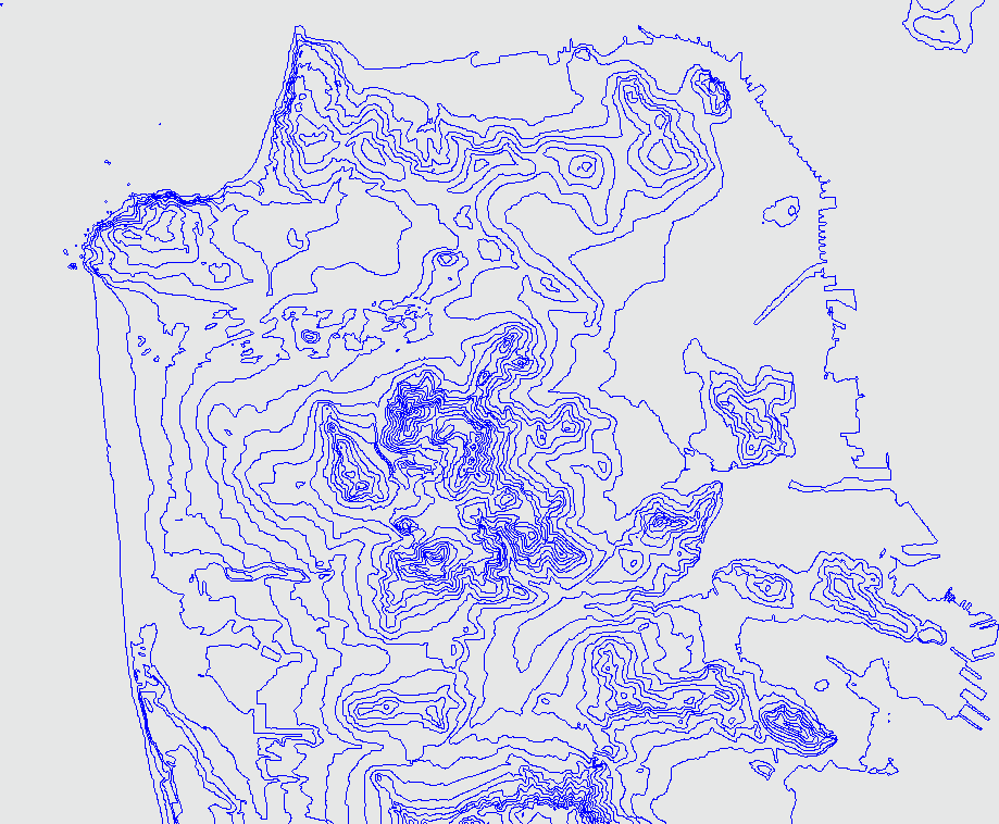
Figure 6-38 shows the contours of San Francisco, shown in blue, with 50-meter steps between contour lines. The result looks pretty good, but the map is a bit busy.
Figure 6-38. A contour map of San Francisco, with 50 m steps between contour lines
We can use the cut parameter for r.contour to clean up the more spurious bits, by discarding contour lines with fewer than a certain number of points. We'll use a value of 200 to demonstrate the effect:
GRASS:~/contour > r.contour in=sf_elevation out=sf_contour
min=0 step=50 cut=200
GRASS:~/contour > d.redraw
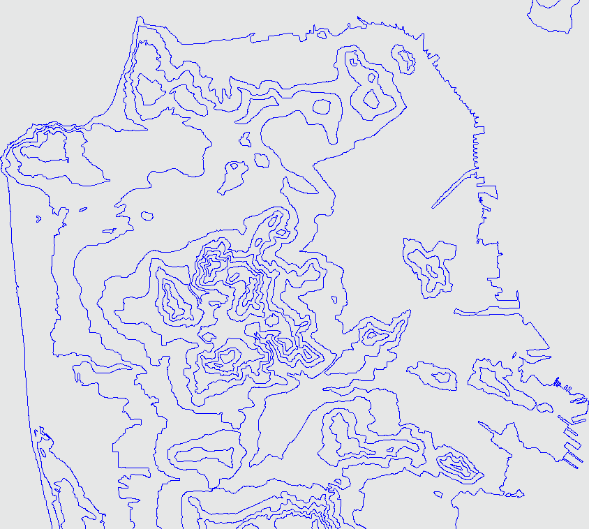
If we place the two maps side by side (perhaps by writing to a different layer and starting another X11 monitor), we can see that our new map sacrifices detail for the sake of clarity. Such is always the prime trade-off inherent in the art of cartography! Another approach we can take, if the contour map still looks too busy, is to raise the step parameter to a higher increment, say, 100 meters:
GRASS:~/contour > r.contour in=sf_elevation out=sf_contour min=0 step=100 cut=50
GRASS:~/contour > d.redraw
Figure 6-39 shows the resulting map, which is enormously simpler, but with the basic information still conveyed. Obviously, you should play with the options for r.contour when mapping your own data and see which set of trade-offs looks best to you.
Figure 6-39. A contour map of San Francisco, with 100 m steps between contour lines.
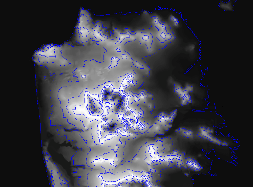
Finally, just to prove to ourselves that this is indeed the elevation data we think we're looking at, let's plot our 100-meter contour map on top of the original elevation data:
GRASS:~/contour > r.colors sf_elevation color=aspect
GRASS:~/contour > d.erase
GRASS:~/contour > d.rast sf_elevation
GRASS:~/contour > d.vect sf_contour color=blue
Sure enough, all the terrain features are still shown in Figure 6-40, now outlined in blue by our contour layer. That's all there is to it!
Figure 6-40. The same contour map, draped over the original elevation model
Now you can use this layer to make new maps or augment other maps in GRASS. You can generate a PostScript rendition of your new contour map for printing to hardcopy [Hack #75] . You can even work with your new contour layer in other mapping applications by exporting it to an ESRI Shapefile:
GRASS:~/contour > v.out.ogr in=sf_contour dsn=. layer=sf_contour type=line
GRASS:~/contour > ls sf_contour*
sf_contour.dbf sf_contour.shp sf_contour.shx
|

Mapping Your Life
- Hacks 1-13
- Hack 1. Put a Map on It: Mapping Arbitrary Locations with Online Services
- Hack 2. Route Planning Online
- Hack 3. Map the Places Youve Visited
- Hack 4. Find Your House on an Aerial Photograph
- Hack 5. The Road Less Traveled by in MapQuest
- Hack 6. Make Route Maps Easier to Read
- Hack 7. Will the Kids Barf?
- Hack 8. Publish Maps of Your Photos on the Web
- Hack 9. Track the Friendly Skies with Sherlock
- Hack 10. Georeference Digital Photos
- Hack 11. How Far? How Fast? Geo-Enabling Your Spreadsheet
- Hack 12. Create a Distance Grid in Excel
- Hack 13. Add Maps to Excel Spreadsheets with MapPoint
Mapping Your Neighborhood
- Hacks 14-21
- Hack 14. Make Free Maps of the United States Online
- Hack 15. Zoom Right In on Your Neighborhood
- Hack 16. Who Are the Neighbors Voting For?
- Hack 17. Map Nearby Wi-Fi Hotspots
- Hack 18. Why You Cant Watch Broadcast TV
- Hack 19. Analyze Elevation Profiles for Wireless Community Networks
- Hack 20. Make 3-D Raytraced Terrain Models
- Hack 21. Map Health Code Violations with RDFMapper
Mapping Your World
- Hacks 22-34
- Hack 22. Digging to China
- Hack 23. Explore David Rumseys Historical Maps
- Hack 24. Explore a 3-D Model of the Entire World
- Hack 25. Work with Multiple Lat/Long Formats
- Hack 26. Work with Different Coordinate Systems
- Hack 27. Calculate the Distance Between Points on the Earths Surface
- Hack 28. Experiment with Different Cartographic Projections
- Hack 29. Plot Arbitrary Points on a World Map
- Hack 30. Plot a Great Circle on a Flat Map
- Hack 31. Plot Dymaxion Maps in Perl
- Hack 32. Hack on Base Maps in Your Favorite Image Editor
- Hack 33. Georeference an Arbitrary Tourist Map
- Hack 34. Map Other Planets
Mapping (on) the Web
- Hacks 35-46
- Hack 35. Search Local, Find Global
- Hack 36. Shorten Online Map URLs
- Hack 37. Tweak the Look and Feel of Web Maps
- Hack 38. Add Location to Weblogs and RSS Feeds
- Hack 39. View Your Photo Thumbnails on a Flash Map
- Hack 40. Plot Points on a Spinning Globe Applet
- Hack 41. Plot Points on an Interactive Map Using DHTML
- Hack 42. Map Your Tracklogs on the Web
- Hack 43. Map Earthquakes in (Nearly) Real Time
- Hack 44. Plot Statistics Against Shapes
- Hack 45. Extract a Spatial Model from Wikipedia
- Hack 46. Map Global Weather Conditions
Mapping with Gadgets
- Hacks 47-63
- How GPS Works
- Hack 47. Get Maps on Your Mobile Phone
- Hack 48. Accessorize Your GPS
- Hack 49. Get Your Tracklogs in Windows or Linux
- Hack 50. The Serial Port to USB Conundrum
- Hack 51. Speak in Geotongues: GPSBabel to the Rescue
- Hack 52. Show Your Waypoints on Aerial Photos with Terrabrowser
- Hack 53. Visualize Your Tracks in Three Dimensions
- Hack 54. Create Your Own Maps for a Garmin GPS
- Hack 55. Use Your Track Memory as a GPS Base Map
- Hack 56. Animate Your Tracklogs
- Hack 57. Connect to Your GPS from Multiple Applications
- Hack 58. Dont Lose Your Tracklogs!
- Hack 59. Geocode Your Voice Recordings and Other Media
- Hack 60. Improve the Accuracy of Your GPS with Differential GPS
- Hack 61. Build a Map of Local GSM Cells
- Hack 62. Build a Car Computer
- Hack 63. Build Your Own Car Navigation System with GpsDrive
Mapping on Your Desktop
- Hacks 64-77
- Hack 64. Mapping Local Areas of Interest with Quantum GIS
- Hack 65. Extract Data from Maps with Manifold
- Hack 66. Java-Based Desktop Mapping with Openmap
- Hack 67. Seamless Data Download from the USGS
- Hack 68. Convert Geospatial Data Between Different Formats
- Hack 69. Find Your Way Around GRASS
- Hack 70. Import Your GPS Waypoints and Tracklogs into GRASS
- Hack 71. Turn Your Tracklogs into ESRI Shapefiles
- Hack 72. Add Relief to Your Topographic Maps
- Hack 73. Make Your Own Contour Maps
- Hack 74. Plot Wireless Network Viewsheds with GRASS
- Hack 75. Share Your GRASS Maps with the World
- Hack 76. Explore the Effects of Global Warming
- Conclusion
- Hack 77. Become a GRASS Ninja
Names and Places
- Hacks 78-86
- Hack 78. What to Do if Your Government Is Hoarding Geographic Data
- Hack 79. Geocode a U.S. Street Address
- Hack 80. Automatically Geocode U.S. Addresses
- Hack 81. Clean Up U.S. Addresses
- Hack 82. Find Nearby Things Using U.S. ZIP Codes
- Hack 83. Map Numerical Data the Easy Way
- Hack 84. Build a Free World Gazetteer
- Hack 85. Geocode U.S. Locations with the GNIS
- Hack 86. Track a Package Across the U.S.
Building the Geospatial Web
- Hacks 87-92
- Hack 87. Build a Spatially Indexed Data Store
- Hack 88. Load Your Waypoints into a Spatial Database
- Hack 89. Publish Your Geodata to the Web with GeoServer
- Hack 90. Crawl the Geospatial Web with RedSpider
- Hack 91. Build Interactive Web-Based Map Applications
- Hack 92. Map Wardriving (and other!) Data with MapServer
Mapping with Other People
- Hacks 93-100
- Hack 93. Node Runner
- Hack 94. Geo-Warchalking with 2-D Barcodes
- Hack 95. Model Interactive Spaces
- Hack 96. Share Geo-Photos on the Web
- Hack 97. Set Up an OpenGuide for Your Hometown
- Hack 98. Give Your Great-Great-Grandfather a GPS
- Hack 99. Map Your Friend-of-a-Friend Network
- Hack 100. Map Imaginary Places
EAN: 2147483647
Pages: 172
