Hack 7. Will the Kids Barf?


Compare road distance with straight-line distance to create an index of nausea.
As I'm blessed with a sweet but stomach-challenged boy, I'm often looking for routes that are less likely to trigger his "I need to throw up; where's your hat, Daddy?" reflex. The quickest way to trigger that impulse is to go too fast on a curvy road.
I originally developed my own little index of road curviness that I called the "quasi-fractal dimension" of a route. As it turns out, the professionals already have their own measure for this property, and our technical reviewer Edward Mac Gillavry set me straight.
In spatial analysis, the network deviousness is the discrepancy between the lengths of the actual routes in a network and the straight-line distance between the places linked up. For any pair of places on the network it can be measured by the detour index. The detour index is a measure of how directly movement may be made on a network. It is calculated as the ratio of the shortest actual route distance between a given pair of nodes and the direct, straight-line or geodesic distance between the same two points.
Detour index = shortest distance on a network between two
points / direct distance * 100.
The minimum value of the index is 100, representing a direct route with no detour. High ratios suggest a weakly connected network but may also reflect the indirectness or deviousness of the individual routes connecting the nodes. The detour index is also referred to as the index of circuity or as the route factor.
So if the straight-line distance between two points is 20 miles, but the road distance is 25 miles, we get a detour index of 25/20 * 100 = 125. The road isn't curvy, honey; it's just devious.
|

1.8.1. Getting the Data
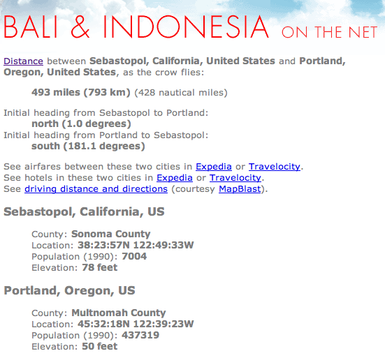
If you know the street address of your starting and ending points, you can use Geocoder.us to get the latitude and longitude, as explained in [Hack #79] Otherwise, try the "How Far Is It" service at http://www.indo.com/distance. You can enter two cities, and "How Far Is It" will return the great-circle distance, as shown in Figure 1-15 (the great-circle distance is the spherical trigonometry version of straight-line distance).
Figure 1-15. How far is it?
If you know the latitude and longitude for each end of your trip, this can be plugged into the "How Far Is It" site. [Hack #11] shows you how to calculate straight-line, "as the crow flies" distance with a "geoenabled" Excel spreadsheet.
Once we have a good direct distance, we can use the techniques described in [Hack #5] to get the estimated time for each segment of the journey, and the "what if the crow has to ride in the back of the van with a hat in his lap" distance. Putting it all together, we get the summary table shown in Figure 1-16.
Figure 1-16. Quantifying physical discomfort
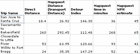
Figure 1-16 shows some trips that are common in my life. The direct distance is the straight-line distance between the two points. Mapquest Distance is the distance reported by MapQuest. Detour Index is calculated as shown earlier. The table also shows the estimated time and the average speed for this trip.
Here we can compare the straight-line distance with the routed distance. Highway 17 over the Santa Cruz Mountains is notoriously curvy. The other numbers yield few surprises. Sacramento to Bakersfield was a ringer! That trip is almost straight down Interstate 5. It has the lowest Detour Index of any of the sample routes.
An awful example of curvy driving is the route from Willits, on highway 101, to Fort Bragg. That section has a 147% distance premium, compared with the straight-line distance.
Assuming these relationships hold true, I can assert that a Detour Index greater than 120 is almost guaranteed to make you sick! I wish to avoid the curvy routes, but some folks like curves, so another use of this technique is to find the curviest possible roads for motorcycle fun. Just remember: for some people, motion sickness is no laughing matter. For the rest of us, it is.
1.8.2. More Information
"How Far Is It" is the creation of Darrell Kindred. It uses the geod program from the PROJ system discussed in much more detail in [Hack #27] . Darrell also has a Perl program to calculate great-circle distances on the earth. His use of geod and his sample code are available at http://www.indo.com/distance/distance-details.html. Another useful page is his discussion of using xearth to create views of the earth, at http://www.indo.com/distance/earth-image-info.html.
Mapping Your Life
- Hacks 1-13
- Hack 1. Put a Map on It: Mapping Arbitrary Locations with Online Services
- Hack 2. Route Planning Online
- Hack 3. Map the Places Youve Visited
- Hack 4. Find Your House on an Aerial Photograph
- Hack 5. The Road Less Traveled by in MapQuest
- Hack 6. Make Route Maps Easier to Read
- Hack 7. Will the Kids Barf?
- Hack 8. Publish Maps of Your Photos on the Web
- Hack 9. Track the Friendly Skies with Sherlock
- Hack 10. Georeference Digital Photos
- Hack 11. How Far? How Fast? Geo-Enabling Your Spreadsheet
- Hack 12. Create a Distance Grid in Excel
- Hack 13. Add Maps to Excel Spreadsheets with MapPoint
Mapping Your Neighborhood
- Hacks 14-21
- Hack 14. Make Free Maps of the United States Online
- Hack 15. Zoom Right In on Your Neighborhood
- Hack 16. Who Are the Neighbors Voting For?
- Hack 17. Map Nearby Wi-Fi Hotspots
- Hack 18. Why You Cant Watch Broadcast TV
- Hack 19. Analyze Elevation Profiles for Wireless Community Networks
- Hack 20. Make 3-D Raytraced Terrain Models
- Hack 21. Map Health Code Violations with RDFMapper
Mapping Your World
- Hacks 22-34
- Hack 22. Digging to China
- Hack 23. Explore David Rumseys Historical Maps
- Hack 24. Explore a 3-D Model of the Entire World
- Hack 25. Work with Multiple Lat/Long Formats
- Hack 26. Work with Different Coordinate Systems
- Hack 27. Calculate the Distance Between Points on the Earths Surface
- Hack 28. Experiment with Different Cartographic Projections
- Hack 29. Plot Arbitrary Points on a World Map
- Hack 30. Plot a Great Circle on a Flat Map
- Hack 31. Plot Dymaxion Maps in Perl
- Hack 32. Hack on Base Maps in Your Favorite Image Editor
- Hack 33. Georeference an Arbitrary Tourist Map
- Hack 34. Map Other Planets
Mapping (on) the Web
- Hacks 35-46
- Hack 35. Search Local, Find Global
- Hack 36. Shorten Online Map URLs
- Hack 37. Tweak the Look and Feel of Web Maps
- Hack 38. Add Location to Weblogs and RSS Feeds
- Hack 39. View Your Photo Thumbnails on a Flash Map
- Hack 40. Plot Points on a Spinning Globe Applet
- Hack 41. Plot Points on an Interactive Map Using DHTML
- Hack 42. Map Your Tracklogs on the Web
- Hack 43. Map Earthquakes in (Nearly) Real Time
- Hack 44. Plot Statistics Against Shapes
- Hack 45. Extract a Spatial Model from Wikipedia
- Hack 46. Map Global Weather Conditions
Mapping with Gadgets
- Hacks 47-63
- How GPS Works
- Hack 47. Get Maps on Your Mobile Phone
- Hack 48. Accessorize Your GPS
- Hack 49. Get Your Tracklogs in Windows or Linux
- Hack 50. The Serial Port to USB Conundrum
- Hack 51. Speak in Geotongues: GPSBabel to the Rescue
- Hack 52. Show Your Waypoints on Aerial Photos with Terrabrowser
- Hack 53. Visualize Your Tracks in Three Dimensions
- Hack 54. Create Your Own Maps for a Garmin GPS
- Hack 55. Use Your Track Memory as a GPS Base Map
- Hack 56. Animate Your Tracklogs
- Hack 57. Connect to Your GPS from Multiple Applications
- Hack 58. Dont Lose Your Tracklogs!
- Hack 59. Geocode Your Voice Recordings and Other Media
- Hack 60. Improve the Accuracy of Your GPS with Differential GPS
- Hack 61. Build a Map of Local GSM Cells
- Hack 62. Build a Car Computer
- Hack 63. Build Your Own Car Navigation System with GpsDrive
Mapping on Your Desktop
- Hacks 64-77
- Hack 64. Mapping Local Areas of Interest with Quantum GIS
- Hack 65. Extract Data from Maps with Manifold
- Hack 66. Java-Based Desktop Mapping with Openmap
- Hack 67. Seamless Data Download from the USGS
- Hack 68. Convert Geospatial Data Between Different Formats
- Hack 69. Find Your Way Around GRASS
- Hack 70. Import Your GPS Waypoints and Tracklogs into GRASS
- Hack 71. Turn Your Tracklogs into ESRI Shapefiles
- Hack 72. Add Relief to Your Topographic Maps
- Hack 73. Make Your Own Contour Maps
- Hack 74. Plot Wireless Network Viewsheds with GRASS
- Hack 75. Share Your GRASS Maps with the World
- Hack 76. Explore the Effects of Global Warming
- Conclusion
- Hack 77. Become a GRASS Ninja
Names and Places
- Hacks 78-86
- Hack 78. What to Do if Your Government Is Hoarding Geographic Data
- Hack 79. Geocode a U.S. Street Address
- Hack 80. Automatically Geocode U.S. Addresses
- Hack 81. Clean Up U.S. Addresses
- Hack 82. Find Nearby Things Using U.S. ZIP Codes
- Hack 83. Map Numerical Data the Easy Way
- Hack 84. Build a Free World Gazetteer
- Hack 85. Geocode U.S. Locations with the GNIS
- Hack 86. Track a Package Across the U.S.
Building the Geospatial Web
- Hacks 87-92
- Hack 87. Build a Spatially Indexed Data Store
- Hack 88. Load Your Waypoints into a Spatial Database
- Hack 89. Publish Your Geodata to the Web with GeoServer
- Hack 90. Crawl the Geospatial Web with RedSpider
- Hack 91. Build Interactive Web-Based Map Applications
- Hack 92. Map Wardriving (and other!) Data with MapServer
Mapping with Other People
- Hacks 93-100
- Hack 93. Node Runner
- Hack 94. Geo-Warchalking with 2-D Barcodes
- Hack 95. Model Interactive Spaces
- Hack 96. Share Geo-Photos on the Web
- Hack 97. Set Up an OpenGuide for Your Hometown
- Hack 98. Give Your Great-Great-Grandfather a GPS
- Hack 99. Map Your Friend-of-a-Friend Network
- Hack 100. Map Imaginary Places
EAN: 2147483647
Pages: 172
