Hacks 87-92
Many of the hacks we've looked at create maps of new, previously unmapped data, such as Wi-Fi usage, your GPS tracklogs, or the news. Most of these hacks are built on top of other maps that give them context. Usually they have a step like "Go to http://example.com/data/download to fetch a certain file." The web sites with the map data are all over the place, and the maps are often in different formats. GIS professionals are used to spending a large amount of time simply finding the data they need to do their actual work.
The notion of a geospatial web seeks to address this problem. Already we have seen the shift the Internet has brought toward textual information, with unheard of quantities of documents a search engine away. The vision for geospatial information has been referred to as a "digital Earth," where you could simply input a point on the globe and have instant access to all mapping data available at that pointnot just what the U.S. census gathered five years ago as TIGER street data, but also the city's zoning information, the current weather map, Rich's favorite bike routes, Jo's corrections on the TIGER street data, public Wi-Fi nodes, and Anselm's social network. Every map created with the help of this book could be available to users online, searchable by coordinates and/or information about the map, and instantly available.
The most immediate effect of this would be more customizable maps; users would be able to select which layers they wanted to display. A map of Wi-Fi nodes could be overlaid on street data, along with the coastline and a common route to work. But the geospatial web could go much further. The Internet has the potential to serve as the transport mechanism for the next leap in mapmaking. GIS as a discipline has essentially passed by most of the potential of computers in favor of traditional mapmaking. The maps currently available on the Internet are essentially paper maps with a nice zoom button. Much more can be done, but only if it is much easier to find and actually use the vast quantities of real spatial information.
The problem with current Internet maps is that you can't really do anything exciting with them because they do not let you have the data behind the maps they provide. You cannot plot your own information on top, combine one map with others, or do any analysis on it. This is because it is a mere picture of the geospatial data. All of the major Internet mapping sites pay large companies like NavTeq for their data. If they gave you real information about the location, then that data would be available to all, since you could systematically step through the U.S. and download a map database. And NavTeq would no longer be able to make money. The geospatial web seeks to make the real data about our world available, which would provide a base for the next leap in mapmaking. It is the canvas upon which new ways of mapping and seeing the world can be painted.
With the advent of the geospatial web, users could customize their display, showing only Wi-Fi nodes that are public or on a particular provider's network. They could get a map layer with all the restaurants in the city and customize that layer to only display the ones that serve Mexican food that someone in their social network has given a five-star rating to, which are within walking distance of their current location. With advances in mobile devices, users could simply ask their PDA for the walking directions to the restaurant selected.
Mapmaking has traditionally been used as a measure of control. Philip II of Spain thought his maps sufficiently subversive to keep them under lock and key as a state secret. To this day, many governments hoard their geospatial data, treating it not as a public utility but as a source of profit. And even in countries like the U.S. that have a general policy of opening their data, it is not always easy to find all the information. A geospatial web would render the commons of information about our world truly useful, making the power of that information accessible in seconds to anyone with an Internet connection. "If a picture or map is a worth a thousand words, then power in the realms of representation may end up being as important as power over the materiality of spatial organization itself." (David Harvey, The Condition of Postmodernity) The geospatial web would put that power in the hands of everyone.
Making all mapping data available to anyone with an Internet connection sounds great, but wouldn't it be a lot of work to actually make that happen? Thankfully a number of smart people have been thinking very hard about this problem for a number of years and have been working together to evolve standards to enable a spatial web. The Internet was around for 20 years before the explosion of the World Wide Web, and arguably the key that allowed that to happen was standards. The disparate programs that operated on the network agreed to operate in a standard way. HTML, HTTP, and TCP/IP are all openly specified for anyone to implement. In the geo world, the OpenGIS Consortium (now the Open Geospatial Consortium, or OGC) has emerged to write specifications for the geospatial web.
The OGC is "a non-profit, international, voluntary consensus standards organization that is leading the development of standards for geospatial and location based services" (from http://opengis.org/). It was founded in 1994, with its roots in the Open GRASS Foundation (OGF), which was created by the GRASS user community to drive a process for the management of GRASS affairs. The OGC emerged to define standards to allow geoprocessing systems to communicate on the Internet through a set of open interfaces. Since 1994, the OGC has grown from 20 member organizations to over 250 from all over the world in commercial, academic, nonprofit, and government sectors.
All standards that the OGC adopts are freely available and directly downloadable from their web site. The process of creation, revision, and adoption is open to any participating company, agency, or organization. Unfortunately membership does cost money, and thus the process is a bit more closed than some other standards organizations, but the OGC is the best hope the geospatial world has, and it does a good job of being as open and inclusive as possible, encouraging participation from varied organizations.
The two most useful OGC specifications, from an end user's perspective, are the Web Map Service (WMS) and Web Feature Service (WFS). Both are web services; instead of returning a web page, they directly return the information the user requests. Both operate over HTTP, so all web browsers, and indeed all clients that use HTTP, can issue requests. Web Map Service is the more established specification; a large number of vendors offer WMS interfaces to their products. The interfaces for WMS and WFS are similar; the main difference is what they return. A WMS returns an image, as a JPEG, a GeoTIFF file, a bitmap, SVG, and so on. It operates like most mapping sites on the Internet, but the key is that it is an interoperable interface, meaning a single client can request maps from all sorts of different servers on the Internet.
The WFS spec does not return images, but raw data in GML (Geographic Markup Language), an XML data format. This allows clients to do far more, as they have the real geographic data, not just a picture of it. A WFS also supports complex filtering operationse.g., "Give me all street names that start with S and are more than two miles long." There are extensions to WMS that allow it to do similar things, but in WFS, you can just request the information directly. The WFS specification also supports Transactions, which facilitate user-supplied changes to GML data, making WFS a generic interface for keeping data up to date. Transactions also allow users to update the maps themselves. Figure 8-1 shows a world map of users of GeoServer, the popular free WFS server. It's viewable online at http://www.moximedia.com:8080/imf-ows/imf.jsp?site=gs_users.
Figure 8-1. GeoServer users shown via a Web Map Service
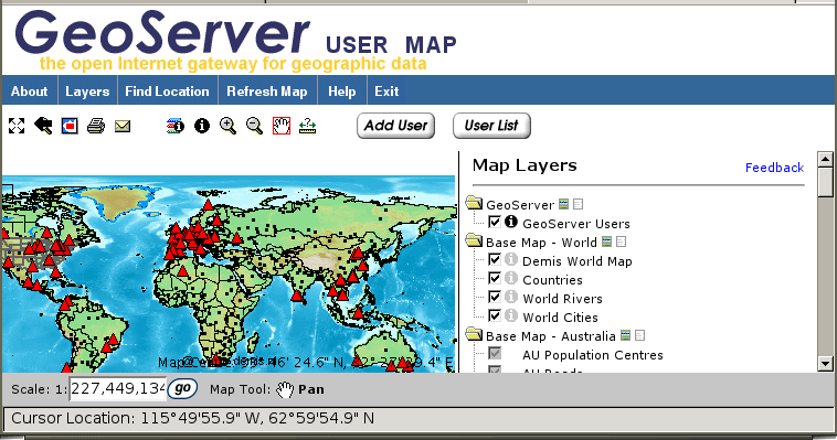
The display is done with a MapServer WMS; when you query it by clicking the "i" button, a WFS command is issued, which gives more detailed information than a WMS can provide. The site also allows you to add yourself to the user map, which issues a WFS Insert request, putting your record in the backend database that the WMS also makes use of. Unfortunately the IMF client site used in this example is not open source, but the backend servers all are.
AskTheSpider (http://www.askthespider.com/) is a geospatial data-discovery service that allows you to search through a registry of different services, using the WFS and WMS protocols to publish on the Web and find different catalogs of geodata.
Right now, WMS and WFS are for early adopters. Why not join them?
Chris Holmes
Mapping Your Life
- Hacks 1-13
- Hack 1. Put a Map on It: Mapping Arbitrary Locations with Online Services
- Hack 2. Route Planning Online
- Hack 3. Map the Places Youve Visited
- Hack 4. Find Your House on an Aerial Photograph
- Hack 5. The Road Less Traveled by in MapQuest
- Hack 6. Make Route Maps Easier to Read
- Hack 7. Will the Kids Barf?
- Hack 8. Publish Maps of Your Photos on the Web
- Hack 9. Track the Friendly Skies with Sherlock
- Hack 10. Georeference Digital Photos
- Hack 11. How Far? How Fast? Geo-Enabling Your Spreadsheet
- Hack 12. Create a Distance Grid in Excel
- Hack 13. Add Maps to Excel Spreadsheets with MapPoint
Mapping Your Neighborhood
- Hacks 14-21
- Hack 14. Make Free Maps of the United States Online
- Hack 15. Zoom Right In on Your Neighborhood
- Hack 16. Who Are the Neighbors Voting For?
- Hack 17. Map Nearby Wi-Fi Hotspots
- Hack 18. Why You Cant Watch Broadcast TV
- Hack 19. Analyze Elevation Profiles for Wireless Community Networks
- Hack 20. Make 3-D Raytraced Terrain Models
- Hack 21. Map Health Code Violations with RDFMapper
Mapping Your World
- Hacks 22-34
- Hack 22. Digging to China
- Hack 23. Explore David Rumseys Historical Maps
- Hack 24. Explore a 3-D Model of the Entire World
- Hack 25. Work with Multiple Lat/Long Formats
- Hack 26. Work with Different Coordinate Systems
- Hack 27. Calculate the Distance Between Points on the Earths Surface
- Hack 28. Experiment with Different Cartographic Projections
- Hack 29. Plot Arbitrary Points on a World Map
- Hack 30. Plot a Great Circle on a Flat Map
- Hack 31. Plot Dymaxion Maps in Perl
- Hack 32. Hack on Base Maps in Your Favorite Image Editor
- Hack 33. Georeference an Arbitrary Tourist Map
- Hack 34. Map Other Planets
Mapping (on) the Web
- Hacks 35-46
- Hack 35. Search Local, Find Global
- Hack 36. Shorten Online Map URLs
- Hack 37. Tweak the Look and Feel of Web Maps
- Hack 38. Add Location to Weblogs and RSS Feeds
- Hack 39. View Your Photo Thumbnails on a Flash Map
- Hack 40. Plot Points on a Spinning Globe Applet
- Hack 41. Plot Points on an Interactive Map Using DHTML
- Hack 42. Map Your Tracklogs on the Web
- Hack 43. Map Earthquakes in (Nearly) Real Time
- Hack 44. Plot Statistics Against Shapes
- Hack 45. Extract a Spatial Model from Wikipedia
- Hack 46. Map Global Weather Conditions
Mapping with Gadgets
- Hacks 47-63
- How GPS Works
- Hack 47. Get Maps on Your Mobile Phone
- Hack 48. Accessorize Your GPS
- Hack 49. Get Your Tracklogs in Windows or Linux
- Hack 50. The Serial Port to USB Conundrum
- Hack 51. Speak in Geotongues: GPSBabel to the Rescue
- Hack 52. Show Your Waypoints on Aerial Photos with Terrabrowser
- Hack 53. Visualize Your Tracks in Three Dimensions
- Hack 54. Create Your Own Maps for a Garmin GPS
- Hack 55. Use Your Track Memory as a GPS Base Map
- Hack 56. Animate Your Tracklogs
- Hack 57. Connect to Your GPS from Multiple Applications
- Hack 58. Dont Lose Your Tracklogs!
- Hack 59. Geocode Your Voice Recordings and Other Media
- Hack 60. Improve the Accuracy of Your GPS with Differential GPS
- Hack 61. Build a Map of Local GSM Cells
- Hack 62. Build a Car Computer
- Hack 63. Build Your Own Car Navigation System with GpsDrive
Mapping on Your Desktop
- Hacks 64-77
- Hack 64. Mapping Local Areas of Interest with Quantum GIS
- Hack 65. Extract Data from Maps with Manifold
- Hack 66. Java-Based Desktop Mapping with Openmap
- Hack 67. Seamless Data Download from the USGS
- Hack 68. Convert Geospatial Data Between Different Formats
- Hack 69. Find Your Way Around GRASS
- Hack 70. Import Your GPS Waypoints and Tracklogs into GRASS
- Hack 71. Turn Your Tracklogs into ESRI Shapefiles
- Hack 72. Add Relief to Your Topographic Maps
- Hack 73. Make Your Own Contour Maps
- Hack 74. Plot Wireless Network Viewsheds with GRASS
- Hack 75. Share Your GRASS Maps with the World
- Hack 76. Explore the Effects of Global Warming
- Conclusion
- Hack 77. Become a GRASS Ninja
Names and Places
- Hacks 78-86
- Hack 78. What to Do if Your Government Is Hoarding Geographic Data
- Hack 79. Geocode a U.S. Street Address
- Hack 80. Automatically Geocode U.S. Addresses
- Hack 81. Clean Up U.S. Addresses
- Hack 82. Find Nearby Things Using U.S. ZIP Codes
- Hack 83. Map Numerical Data the Easy Way
- Hack 84. Build a Free World Gazetteer
- Hack 85. Geocode U.S. Locations with the GNIS
- Hack 86. Track a Package Across the U.S.
Building the Geospatial Web
- Hacks 87-92
- Hack 87. Build a Spatially Indexed Data Store
- Hack 88. Load Your Waypoints into a Spatial Database
- Hack 89. Publish Your Geodata to the Web with GeoServer
- Hack 90. Crawl the Geospatial Web with RedSpider
- Hack 91. Build Interactive Web-Based Map Applications
- Hack 92. Map Wardriving (and other!) Data with MapServer
Mapping with Other People
- Hacks 93-100
- Hack 93. Node Runner
- Hack 94. Geo-Warchalking with 2-D Barcodes
- Hack 95. Model Interactive Spaces
- Hack 96. Share Geo-Photos on the Web
- Hack 97. Set Up an OpenGuide for Your Hometown
- Hack 98. Give Your Great-Great-Grandfather a GPS
- Hack 99. Map Your Friend-of-a-Friend Network
- Hack 100. Map Imaginary Places
EAN: 2147483647
Pages: 172
- ERP Systems Impact on Organizations
- Enterprise Application Integration: New Solutions for a Solved Problem or a Challenging Research Field?
- The Effects of an Enterprise Resource Planning System (ERP) Implementation on Job Characteristics – A Study using the Hackman and Oldham Job Characteristics Model
- Context Management of ERP Processes in Virtual Communities
- Intrinsic and Contextual Data Quality: The Effect of Media and Personal Involvement
