Hack 36. Calculate the Distance Between GPS Locations


If you have GPS coordinates you can calculate the distance between two points.
GPS coordinates are latitude, longitude, and altitude values. With a little trigonometry you can calculate the "crow flies" distance between two pairs of ordinates.
When the two points are close together (no more than a few hundred miles) you can approximate by treating the Earth's surface as flat rather than curved. A single degree of latitude translates to about 111 km (69 miles) everywhere on the planet. That is 6378p / 180° km. The radius of the Earth is 6378 km or 3,963 miles.
A degree of longitude varies. At the equator one degree of longitude is worth the same as one degree of latitude, but at higher latitudes the lines get closer together: in Edinburgh Scotland, at a latitude of 56°, a single degree of longitude is only 62 km. That is (6378km)p(cos(56°)) / 180°.
Suppose you have some GPS coordinates in a table, as shown in Table 5-17.
| name | North (latitude) | East (longitude) |
|---|---|---|
| home | 55.954742 | 3.207630 |
| napier | 55.932809 | 3.214617 |
| zzuli | 34.749660 | 113.670094 |
You need to turn these values into radians before you can apply the trig functions. You are also going to need the radius of the Earth so that you can put that in as a constant:
CREATE VIEW gpsRad AS
 SELECT name, 3.14159265359*e/180 AS lon
 , 3.14159265359*n/180 AS lat
 , 6378 AS R
 FROM gps
Work (napier) is dx kilometers east of Home and dy kilometers to the north in this query:
mysql> SELECT p1.R*(p2.lon-p1.lon)*COS(p1.lat) AS dx,
 -> p1.R*(p2.lat-p1.lat) AS dy
 -> FROM gpsRad p1 JOIN gpsRad p2
 -> ON (p1.name='home' AND p2.name='napier');
+-------------------+------------------+
| dx | dy |
+-------------------+------------------+
| -0.43544683467495 | -2.4417242388667 |
+-------------------+------------------+
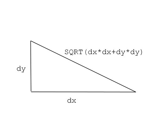
To get the actual distance in kilometers you need to apply the Pythagorean theorem, as shown in the following code snippet and illustrated in Figure 5-3:
mysql> SELECT SQRT(dx*dx+dy*dy) FROM
 -> (SELECT p1.R*(p2.lon-p1.lon)*COS(p1.lat) AS dx,
 -> p1.R*(p2.lat-p1.lat) AS dy
 -> FROM gpsRad p1 JOIN gpsRad p2
 -> ON (p1.name='home' AND p2.name='napier')) t;
+-------------------+
| SQRT(dx*dx+dy*dy) |
+-------------------+
| 2.4802482142918 |
+-------------------+
Figure 5-3. Calculating the distance from dx and dy
5.13.1. Hacking the Hack
If you want to measure bigger distances you need to do the 3D geometry properly. Using the preceding method to measure the distance between the ZhengZhou University of Light Industry in China and Napier University in the UK gives:
mysql> SELECT SQRT(dx*dx+dy*dy) FROM
 -> (SELECT p1.R*(p2.lon-p1.lon)*COS(p1.lat) AS dx,
 -> p1.R*(p2.lat-p1.lat) AS dy
 -> FROM gpsRad p1 JOIN gpsRad p2
 -> ON (p1.name='zzuli' AND p2.name='napier')) t;
+-------------------+
| SQRT(dx*dx+dy*dy) |
+-------------------+
| 10947.852030902 |
+-------------------+
You know that there is a problem because if you estimate the distance from the UK to China by swapping the start and end points, it comes out as:
mysql> SELECT SQRT(dx*dx+dy*dy) FROM
 -> (SELECT p1.R*(p2.lon-p1.lon)*COS(p1.lat) AS dx,
 -> p1.R*(p2.lat-p1.lat) AS dy
 -> FROM gpsRad p1 JOIN gpsRad p2
 -> ON (p1.name='napier' AND p2.name='zzuli')) t;
+-------------------+
| SQRT(dx*dx+dy*dy) |
+-------------------+
| 7660.533655487 |
+-------------------+
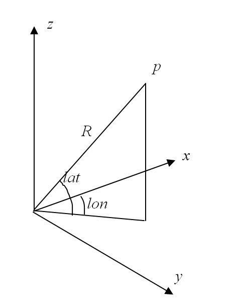
The GPS ordinates are the lon and lat angles in Figure 5-4. You can work out the (x,y,z) coordinates, relative to the center of the Earth. With two triples of x, y, z you can apply the Pythagorean theorem, which will give you the straight line distance:
x = R cos(lat) cos(lon)
y = R cos(lat) sin(lon)
z = R sin(lat)
Figure 5-4. (x,y z) coordinates from latitude and longitude
The gpsTrig view does the trigonometry calculations based on the gpsRad view from before:
CREATE VIEW gpsTrig AS
 SELECT name, R, COS(lat) AS cos_lat, SIN(lat) AS sin_lat,
 COS(lon) AS cos_lon, SIN(lon) AS sin_lon
 FROM gpsRad;
Now you can calculate the x, y, and z coordinates relative to the center of the Earth:
CREATE VIEW gpsGlb AS
 SELECT name, R*cos_lat*cos_lon AS x,
 R*cos_lat*sin_lon AS y,
 R*sin_lat AS z
 FROM gpsTrig;
You also can find the vector between two points in three dimensions:
mysql> SELECT p1.x-p2.x AS dx, p1.y-p2.y AS dy, p1.z-p2.z AS dz
 -> FROM gpsGlb p1 JOIN gpsGlb p2
 -> ON (p1.name='zzuli' AND p2.name='napier');
+------------------+-----------------+------------------+
| dx | dy | dz |
+------------------+-----------------+------------------+
| -5671.0949161728 | 5000.0390465225 | -1648.0329880006 |
+------------------+-----------------+------------------+
To find the distance in kilometers you must apply the Pythagorean theorem:
mysql> SELECT SQRT(dx*dx+dy*dy+dz*dz) FROM
 -> (SELECT p1.x-p2.x AS dx, p1.y-p2.y AS dy, p1.z-p2.z AS dz
 -> FROM gpsGlb p1 JOIN gpsGlb p2
 -> ON (p1.name='zzuli' AND p2.name='napier')) t;
+-------------------------+
| SQRT(dx*dx+dy*dy+dz*dz) |
+-------------------------+
| 7738.0695748054 |
+-------------------------+
Of course, this is the straight line distancein the worst case, this route will take you right through Earth's molten core. It's probably better to go around the outside, and you can make that adjustment with just a little more circle geometry, as shown in Figure 5-5.
Figure 5-5. Calculating the length of an arc
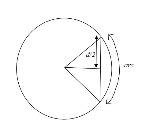
To get the length of the arc where the straight line distance is d you can use 2*R*asin(d/2/R), where R is the radius of the circle:
mysql> SELECT 2*R*ASIN(d/2/R) AS arc FROM
 -> (SELECT 6378 AS R) t0,
 -> (SELECT SQRT(dx*dx+dy*dy+dz*dz) AS d FROM
 -> (SELECT p1.x-p2.x AS dx, p1.y-p2.y AS dy, p1.z-p2.z AS dz
 -> FROM gpsGlb p1 JOIN gpsGlb p2
 -> ON (p1.name='zzuli' AND p2.name='napier')
 -> ) t1) t2;
+-----------------+
| arc |
+-----------------+
| 8314.4181316969 |
+-----------------+
SQL Fundamentals
- SQL Fundamentals
- Hack 1. Run SQL from the Command Line
- Hack 2. Connect to SQL from a Program
- Hack 3. Perform Conditional INSERTs
- Hack 4. UPDATE the Database
- Hack 5. Solve a Crossword Puzzle Using SQL
- Hack 6. Dont Perform the Same Calculation Over and Over
Joins, Unions, and Views
- Joins, Unions, and Views
- Hack 7. Modify a Schema Without Breaking Existing Queries
- Hack 8. Filter Rows and Columns
- Hack 9. Filter on Indexed Columns
- Hack 10. Convert Subqueries to JOINs
- Hack 11. Convert Aggregate Subqueries to JOINs
- Hack 12. Simplify Complicated Updates
- Hack 13. Choose the Right Join Style for Your Relationships
- Hack 14. Generate Combinations
Text Handling
- Text Handling
- Hack 15. Search for Keywords Without LIKE
- Hack 16. Search for a String Across Columns
- Hack 17. Solve Anagrams
- Hack 18. Sort Your Email
Date Handling
- Date Handling
- Hack 19. Convert Strings to Dates
- Hack 20. Uncover Trends in Your Data
- Hack 21. Report on Any Date Criteria
- Hack 22. Generate Quarterly Reports
- Hack 23. Second Tuesday of the Month
Number Crunching
- Number Crunching
- Hack 24. Multiply Across a Result Set
- Hack 25. Keep a Running Total
- Hack 26. Include the Rows Your JOIN Forgot
- Hack 27. Identify Overlapping Ranges
- Hack 28. Avoid Dividing by Zero
- Hack 29. Other Ways to COUNT
- Hack 30. Calculate the Maximum of Two Fields
- Hack 31. Disaggregate a COUNT
- Hack 32. Cope with Rounding Errors
- Hack 33. Get Values and Subtotals in One Shot
- Hack 34. Calculate the Median
- Hack 35. Tally Results into a Chart
- Hack 36. Calculate the Distance Between GPS Locations
- Hack 37. Reconcile Invoices and Remittances
- Hack 38. Find Transposition Errors
- Hack 39. Apply a Progressive Tax
- Hack 40. Calculate Rank
Online Applications
- Online Applications
- Hack 41. Copy Web Pages into a Table
- Hack 42. Present Data Graphically Using SVG
- Hack 43. Add Navigation Features to Web Applications
- Hack 44. Tunnel into MySQL from Microsoft Access
- Hack 45. Process Web Server Logs
- Hack 46. Store Images in a Database
- Hack 47. Exploit an SQL Injection Vulnerability
- Hack 48. Prevent an SQL Injection Attack
Organizing Data
- Organizing Data
- Hack 49. Keep Track of Infrequently Changing Values
- Hack 50. Combine Tables Containing Different Data
- Hack 51. Display Rows As Columns
- Hack 52. Display Columns As Rows
- Hack 53. Clean Inconsistent Records
- Hack 54. Denormalize Your Tables
- Hack 55. Import Someone Elses Data
- Hack 56. Play Matchmaker
- Hack 57. Generate Unique Sequential Numbers
Storing Small Amounts of Data
- Storing Small Amounts of Data
- Hack 58. Store Parameters in the Database
- Hack 59. Define Personalized Parameters
- Hack 60. Create a List of Personalized Parameters
- Hack 61. Set Security Based on Rows
- Hack 62. Issue Queries Without Using a Table
- Hack 63. Generate Rows Without Tables
Locking and Performance
- Locking and Performance
- Hack 64. Determine Your Isolation Level
- Hack 65. Use Pessimistic Locking
- Hack 66. Use Optimistic Locking
- Hack 67. Lock Implicitly Within Transactions
- Hack 68. Cope with Unexpected Redo
- Hack 69. Execute Functions in the Database
- Hack 70. Combine Your Queries
- Hack 71. Extract Lots of Rows
- Hack 72. Extract a Subset of the Results
- Hack 73. Mix File and Database Storage
- Hack 74. Compare and Synchronize Tables
- Hack 75. Minimize Bandwidth in One-to-Many Joins
- Hack 76. Compress to Avoid LOBs
Reporting
- Reporting
- Hack 77. Fill in Missing Values in a Pivot Table
- Hack 78. Break It Down by Range
- Hack 79. Identify Updates Uniquely
- Hack 80. Play Six Degrees of Kevin Bacon
- Hack 81. Build Decision Tables
- Hack 82. Generate Sequential or Missing Data
- Hack 83. Find the Top n in Each Group
- Hack 84. Store Comma-Delimited Lists in a Column
- Hack 85. Traverse a Simple Tree
- Hack 86. Set Up Queuing in the Database
- Hack 87. Generate a Calendar
- Hack 88. Test Two Values from a Subquery
- Hack 89. Choose Any Three of Five
Users and Administration
- Users and Administration
- Hack 90. Implement Application-Level Accounts
- Hack 91. Export and Import Table Definitions
- Hack 92. Deploy Applications
- Hack 93. Auto-Create Database Users
- Hack 94. Create Users and Administrators
- Hack 95. Issue Automatic Updates
- Hack 96. Create an Audit Trail
Wider Access
- Wider Access
- Sharing Data Across the Internet
- Hack 97. Allow an Anonymous Account
- Hack 98. Find and Stop Long-Running Queries
- Hack 99. Dont Run Out of Disk Space
- Hack 100. Run SQL from a Web Page
Index
EAN: 2147483647
Pages: 147
