Hack 54. Add a Nicer Info Window to Your Map with TLabel


Callouts, info windowsanything that can fit on a web pagecan fit on a map.
The early Google Maps hacks share a similar affliction: they suffer from red pushpin syndrome. Sometimes the pushpins are green. You can create custom icons, but they are a bit of a challenge, and then you just get a different little symbol.
What you (might) want is the ability to customize the map with unique info windows, images, callouts, and anything else that strikes your fancy. Tom Mangan created the TLabel extension to allow you to embed any DOM object (anything that can appear on a web page) on a Google Map. Figure 6-8 shows Tom's canonical example from the TLabel page at http://gmaps.tommangan.us/tlabel.html, with a Google satellite image of two U.S.
Air Force SR-71 Blackbirds and a U-2 spy plane at the Blackbird Air Park, in Palmdale, CA. (For the curious, this is at 34.602975 N, 118.085926 W.)
Figure 6-8. SR-71s at the Blackbird Air Park, with TLabel annotations
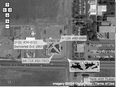
Callouts identify each plane. The numbers are links to sites that have more information on each plane. There is also a thumbnail image that was taken from ground level. The image has a tool tip that reads "Click for larger." Surprisingly, clicking on that link leads to a larger image of that thumbnail.
6.5.1. Using TLabel
The TLabel page is at http://gmaps.tommangan.us/tlabel.html. There is a link to a JavaScript file, currently http://gmaps.tommangan.us/tlabel.19.js, but check for the current version. Copy that file onto your own server and include it after you include the Google Maps API.
Now, create some objects! You control the TLabel object by creating a new object and then setting the properties. There is a demo of some TLabel tricks at http://mappinghacks.com/projects/gmaps/brc_tlabel.html. Here is code to create a label, as shown in Figure 6-9:
	var label = new TLabel();
	label.id = 'mail_box';
	label.anchorLatLng = new GPoint (-119.226396, 40.768080);
	label.anchorPoint = 'bottomLeft';
	label.content = 'Mail Box';
	label.percentOpacity = 85;
	map.addTLabel(label);
Figure 6-9. Black Rock City, annotated with TLabels
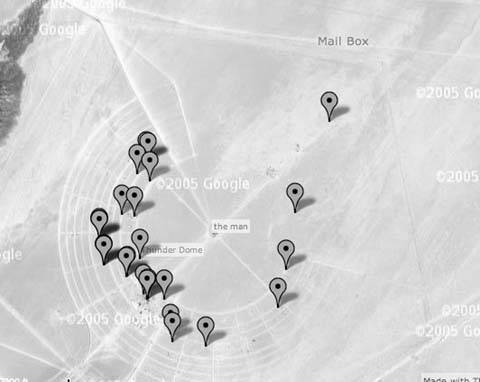
First, the code declares the variable named label to hold the newly created TLabel object. Next, we set the id of the TLabel. The id is vital! It must be unique. It is easy, and catastrophic, to end up with a duplicate label (where catastrophic means it doesn't work). The anchorLatLng is a GPoint object, i.e., the location where this object is anchored to the earth. The anchorPoint defines which part of the content will touch the anchor lat and long.
In this case, bottomLeft means that the bottom-left corner of our marker hits the point in the anchorLatLng. The choices are topLeft, topCenter, topRight, midRight, bottomRight, bottomCenter, bottomLeft, midLeft, or center. The default is topLeft. The content can be anything that can fit on a web page! In this case, we use the words "Mail Box." Table 6-1 summarizes these properties.
Once you have created the TLabel object and set the properties, there are four useful methods: add the object to your map with map.addTLabel(label), remove it with map.removeTLabel(label), move it around with label.setPosition(GPoint), or change its opacity (100% means you can't see through it at all) with label.setOpacity(percentage).
|
Property |
Description |
|---|---|
|
id |
Specifies an ID for the label object. This ID is required and must be unique for each label you embed. The ID is exposed to the DOM, so you can dynamically adjust the label's style if you choose. |
|
anchorLatLng |
The longitude and latitude where the anchorPoint will be pinned to the map. Takes a GPoint object. |
|
anchorPoint |
The point on your embedded object that will be pinned to anchorLatLng. anchorPoint accepts the following values: topLeft, topCenter, topRight, midRight, bottomRight, bottomCenter, bottomLeft, midLeft, and center. The default is topLeft. |
|
content |
The XHTML code defining the element you wish to embed. |
|
percentOpacity |
A number between 0 and 100 inclusive, determining the opacity of the image. Default is 100, i.e., completely opaque. |
You can replace the content with something more elaborate. This implements an onMouseOver event; so moving the mouse over the image pops up more information (i.e., a tool tip).
label.content = '';
It is all a question of controlling what is in the content variable. You can put the whole thing into one string or split it across lines. If you split it, you need to remember to terminate each line of a multiline section with a quote or you'll get an "unterminated string literal" message.
Check out Tom's site at http://gmaps.tommangan.us/ for more nifty hacks.
written with assistance from Tom Mangan
You Are Here: Introducing Google Maps
- Hacks 19: Introduction
- Hack 1. Get Around http://maps.google.com
- Hack 2. Find Yourself (and Others) on Google Maps
- Hack 3. Navigate the World in Your Web Browser
- Hack 4. Get the Birds-Eye View
- Hack 5. Driven to a Better User Interface
- Hack 6. Share Google Maps
- Hack 7. Inside Google Maps URLs
- Hack 8. Generate Links to Google Maps in a Spreadsheet
- Hack 9. Use del.icio.us to Keep Up with Google Maps
Introducing the Google Maps API
- Hacks 1016: Introduction
- Hack 10. Add a Google Map to Your Web Site
- Hack 11. Where Did the User Click?
- Hack 12. How Far Is That? Go Beyond Driving Directions
- Hack 13. Create a Route with a Click (or Two)
- Hack 14. Create Custom Map Markers
- Hack 15. Map a Slideshow of Your Travels
- Hack 16. How Big Is the World?
Mashing Up Google Maps
- Hacks 1728: Introduction
- Hack 17. Map the News
- Hack 18. Examine Patterns of Criminal Activity
- Hack 19. Map Local Weather Conditions
- Hack 20. Track Official Storm Reporting
- Hack 21. Track the International Space Station
- Hack 22. Witness the Effects of a Nuclear Explosion
- Hack 23. Find a Place to Live
- Hack 24. Search for Events by Location
- Hack 25. Track Your UPS Packages
- Hack 26. Follow Your Packets Across the Internet
- Hack 27. Add Google Maps to Any Web Site
- Hack 28. How Big Is That, Exactly?
On the Road with Google Maps
- Hacks 2941: Introduction
- Hack 29. Find the Best Gasoline Prices
- Hack 30. Stay Out of Traffic Jams
- Hack 31. Navigate Public Transportation
- Hack 32. Locate a Phone Number
- Hack 33. Why Your Cell Phone Doesnt Work There
- Hack 34. Publish Your Own Hiking Trail Maps
- Hack 35. Load Driving Directions into Your GPS
- Hack 36. Get Driving Directions for More Than Two Locations
- Hack 37. View Your GPS Tracklogs in Google Maps
- Hack 38. Map Your Wardriving Expeditions
- Hack 39. Track Your Every Move with Google Earth
- Hack 40. The Ghost in Google Ride Finder
- Hack 41. How Google Maps Got Me Out of a Traffic Ticket
Google Maps in Words and Pictures
- Hacks 4250: Introduction
- Hack 42. Get More out of What You Read
- Hack 43. Dont Believe Everything You Read on a Map
- Hack 44. You Got Your A9 Local in My Google Maps!
- Hack 45. Share Pictures with Your Community
- Hack 46. Browse Photography by Shooting Location
- Hack 47. Geotag Your Own Photos on Flickr
- Hack 48. Tell Your Communitys Story
- Hack 49. Generate Geocoded RSS from Any Google Map
- Hack 50. Geoblog with Google Maps in Thingster
API Tips and Tricks
- Hacks 5161: Introduction
- Hack 51. Make a Fullscreen Map the Right Way
- Hack 52. Put a Map and HTML into Your Info Windows
- Hack 53. Add Flash Applets to Your Google Maps
- Hack 54. Add a Nicer Info Window to Your Map with TLabel
- Hack 55. Put Photographs on Your Google Maps
- Hack 56. Pin Your Own Maps to Google Maps with TPhoto
- Hack 57. Do a Local Zoom with GxMagnifier
- Hack 58. Find the Right Zoom Level
- Hack 59. Show Lots of StuffQuickly
- Hack 60. Make Things Happen When the Map Moves
- Hack 61. Use the Right Developers Key Automatically
Extreme Google Maps Hacks
- Hacks 6270: Introduction
- Hack 62. Find the Latitude and Longitude of a Street Address
- Hack 63. Read and Write Markers from a MySQL Database
- Hack 64. Build Custom Icons on the Fly
- Hack 65. Add More Imagery with a WMS Interface
- Hack 66. Add Your Own Custom Map
- Hack 67. Serve Custom Map Imagery
- Hack 68. Automatically Cut and Name Custom Map Tiles
- Hack 69. Cluster Markers at High Zoom Levels
- Hack 70. Will the Kids Barf? (and Other Cool Ways to Use Google Maps)
EAN: 2147483647
Pages: 131
