Hack 56. Pin Your Own Maps to Google Maps with TPhoto


Georeference your own maps and then pin them anywhere.
The first time I visited New York City from the Bay Area, I was excited to see everything, all at once. I figured that Manhatten is small, about 10 1/2 miles from tip to tip, and the boroughs are just a bit larger. How long could it take to go 10 miles?
A temporary New Yorker friend told me, "You can think of Manhattan as being the whole Bay Area. Sure you can drive from Palo Alto to San Francisco, across to Oakland and down the East Bay to San Jose, but would you? Manhattan is physically smaller, but in terms of travel times it is similar."
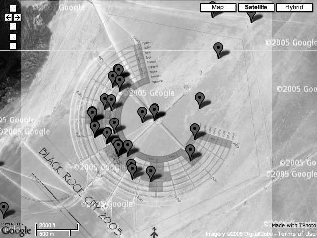
We can use TPhoto [Hack #55] to take an image of one place and center it in another. At http://www.mappinghacks.com/projects/gmaps/brc_ref.html you see the Google aerial photo of the site of the Burning Man festival in the Black Rock desert of Nevada. If you click "show plan," you'll get the 2005 Burning Man city plan overlaid on the Google Map as shown in Figure 6-14.
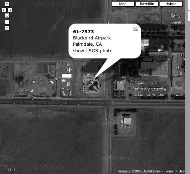
Figure 6-13. Blackbirds at 100% opacity
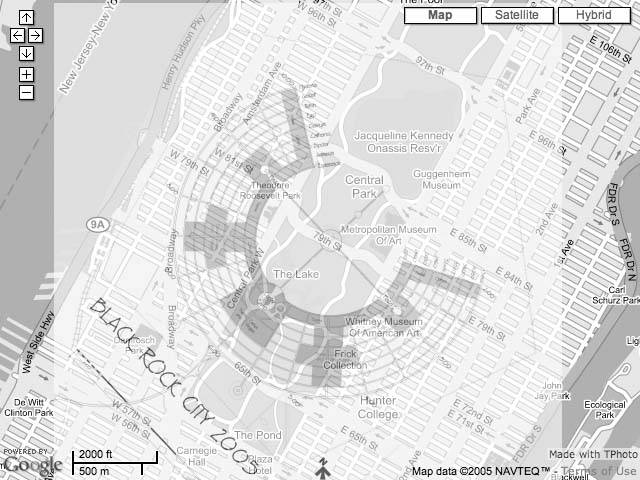
But you don't have to overlay the city plan on the Google Map in the proper place! You can scroll the map to another area and then click on a point to overlay the city map on that point. Figure 6-15 shows a hypothetical Burning Apple festival centered on 79th Street in the middle of Central Park.
It is interesting that Manhattan is oriented nearly the same way as the Playa, from southwest to northeast, and the Festival covers about two-thirds of the width of Manhattan. The Metropolitan Museum of Art ends up more or less by the Large Scale Sound installations.
The distance from Center Camp to the perimeter fence is about 27 city blocksfrom 72nd Street to 99th Street. And moving out a few zoom levels leaves us in awe at how tremendously big and dense an experience it is to be in New York.
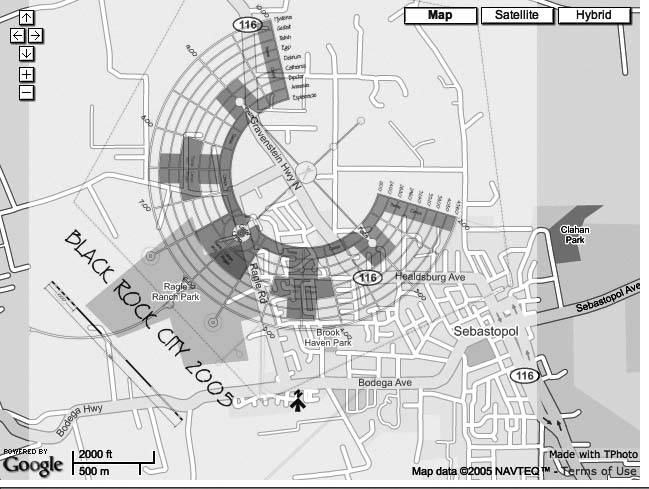
Taking it home, way home to Sebastopol, and centering on O'Reilly, gives us the results in Figure 6-16.
This was produced with the single-point method of TPhoto [Hack #55]. This makes TPhoto work as a simple georeferencing tool. Georeferencing is the act of mapping the pixel space of an image to a coordinate system that is pegged to the earth's surface.
Figure 6-14. Black Rock City in its proper place
You need to provide the image size, zoom level, and a single point. But we can change the properties of a TImage object dynamically. As an example, let's georeference the Black Rock City 2005 Plan. You can download the 65KB PDF image from http://www.burningman.com/preparation/maps/05_maps/. First convert the PDF to a JPEG. You can do this in any image-processing tool. If you have ImageMagick installed, this command works:
convert brc_2005.pdf brc_2005.jpg
Next, you need to find the pixel coordinates of a recognizable point. I used the GIMP to edit the image. Photoshop would also work. Open the image, then zoom in and place the cursor right over the Man. I get x=917, y=963. Also note the height and width of the image: 1833 x 2274.
Finally, you need to rotate the image so that North is up. I used the rotate tool to align the grids with the North arrow. It was a -37 degree rotation.
This is the core code that overlays the image:
	var brc = new TPhoto();
	brc.id = 'brc';
	brc.src='images/brc_2005_rotate.jpg';
	brc.size = new GSize(2032, 2432);
	brc.baseZoom = 1;
	brc.percentOpacity = 40;
	brc.anchorPx = new GPoint(1110, 948);
	brc.anchorLatLng = new GPoint(-119.23616409301758,40.754279292683094);
Figure 6-15. Black Rock City centered on Central Park
This loads the image images/brc_2005_rotate.jpg and centers it so that the x,y pixel coordinate maps to the passed lat/long. You can adjust the Gsize (specified in pixels) and baseZoom so that the displayed image takes up the right amount of space. This happens automatically with the two-point use of TPhoto.
You can change the opacity of the overlaid image [Hack #55]. This HTML defines two buttons that increase and decrease the photo opacity when they are clicked:
When the buttons are clicked, either +10 or 10 is passed to the changeOpacity method:
Figure 6-16. Black Rock City centered on O'Reilly Media
	function changeOpacity (z) {
	 var temp = brc.percentOpacity;
	 temp += z;
	 if (temp > 100) {
	 temp = 100;
	 }
	 if (temp < 0) {
	 temp = 0;
	 }
	 map.removeTPhoto(brc);
	 brc.percentOpacity = temp;
	 map.addTPhoto(brc);
	 document.getElementById('opacity').value = brc.percentOpacity;
	}
This routine attempts to increase or decrease the opacity by the passed +10 or -10 and then checks that the opacity is not greater than 100 or less than 0. Assuming it is within range, it removes the photo from the active map, sets the opacity to the new value, and then redisplays the image and updates the displayed opacity.
The showImage method is called when the user clicks "show plan," and is even more simple:
	function showImage() {

	 show = 1-show;
	 if (show == 1) {
	 map.addTPhoto(brc);
	 document.getElementById('showplan').value = 'hide Plan';
	 } else {
	 map.removeTPhoto(brc);
	 document.getElementById('showplan').value = 'show Plan';
	 }
	}
The variable show serves as a toggle. It is initially set to 0, and then the line show=1-show toggles it between 1 and 0. When it is 1 the photo is displayed and when it is 0 the photo is hidden.
You Are Here: Introducing Google Maps
- Hacks 19: Introduction
- Hack 1. Get Around http://maps.google.com
- Hack 2. Find Yourself (and Others) on Google Maps
- Hack 3. Navigate the World in Your Web Browser
- Hack 4. Get the Birds-Eye View
- Hack 5. Driven to a Better User Interface
- Hack 6. Share Google Maps
- Hack 7. Inside Google Maps URLs
- Hack 8. Generate Links to Google Maps in a Spreadsheet
- Hack 9. Use del.icio.us to Keep Up with Google Maps
Introducing the Google Maps API
- Hacks 1016: Introduction
- Hack 10. Add a Google Map to Your Web Site
- Hack 11. Where Did the User Click?
- Hack 12. How Far Is That? Go Beyond Driving Directions
- Hack 13. Create a Route with a Click (or Two)
- Hack 14. Create Custom Map Markers
- Hack 15. Map a Slideshow of Your Travels
- Hack 16. How Big Is the World?
Mashing Up Google Maps
- Hacks 1728: Introduction
- Hack 17. Map the News
- Hack 18. Examine Patterns of Criminal Activity
- Hack 19. Map Local Weather Conditions
- Hack 20. Track Official Storm Reporting
- Hack 21. Track the International Space Station
- Hack 22. Witness the Effects of a Nuclear Explosion
- Hack 23. Find a Place to Live
- Hack 24. Search for Events by Location
- Hack 25. Track Your UPS Packages
- Hack 26. Follow Your Packets Across the Internet
- Hack 27. Add Google Maps to Any Web Site
- Hack 28. How Big Is That, Exactly?
On the Road with Google Maps
- Hacks 2941: Introduction
- Hack 29. Find the Best Gasoline Prices
- Hack 30. Stay Out of Traffic Jams
- Hack 31. Navigate Public Transportation
- Hack 32. Locate a Phone Number
- Hack 33. Why Your Cell Phone Doesnt Work There
- Hack 34. Publish Your Own Hiking Trail Maps
- Hack 35. Load Driving Directions into Your GPS
- Hack 36. Get Driving Directions for More Than Two Locations
- Hack 37. View Your GPS Tracklogs in Google Maps
- Hack 38. Map Your Wardriving Expeditions
- Hack 39. Track Your Every Move with Google Earth
- Hack 40. The Ghost in Google Ride Finder
- Hack 41. How Google Maps Got Me Out of a Traffic Ticket
Google Maps in Words and Pictures
- Hacks 4250: Introduction
- Hack 42. Get More out of What You Read
- Hack 43. Dont Believe Everything You Read on a Map
- Hack 44. You Got Your A9 Local in My Google Maps!
- Hack 45. Share Pictures with Your Community
- Hack 46. Browse Photography by Shooting Location
- Hack 47. Geotag Your Own Photos on Flickr
- Hack 48. Tell Your Communitys Story
- Hack 49. Generate Geocoded RSS from Any Google Map
- Hack 50. Geoblog with Google Maps in Thingster
API Tips and Tricks
- Hacks 5161: Introduction
- Hack 51. Make a Fullscreen Map the Right Way
- Hack 52. Put a Map and HTML into Your Info Windows
- Hack 53. Add Flash Applets to Your Google Maps
- Hack 54. Add a Nicer Info Window to Your Map with TLabel
- Hack 55. Put Photographs on Your Google Maps
- Hack 56. Pin Your Own Maps to Google Maps with TPhoto
- Hack 57. Do a Local Zoom with GxMagnifier
- Hack 58. Find the Right Zoom Level
- Hack 59. Show Lots of StuffQuickly
- Hack 60. Make Things Happen When the Map Moves
- Hack 61. Use the Right Developers Key Automatically
Extreme Google Maps Hacks
- Hacks 6270: Introduction
- Hack 62. Find the Latitude and Longitude of a Street Address
- Hack 63. Read and Write Markers from a MySQL Database
- Hack 64. Build Custom Icons on the Fly
- Hack 65. Add More Imagery with a WMS Interface
- Hack 66. Add Your Own Custom Map
- Hack 67. Serve Custom Map Imagery
- Hack 68. Automatically Cut and Name Custom Map Tiles
- Hack 69. Cluster Markers at High Zoom Levels
- Hack 70. Will the Kids Barf? (and Other Cool Ways to Use Google Maps)
EAN: 2147483647
Pages: 131
- Challenging the Unpredictable: Changeable Order Management Systems
- ERP System Acquisition: A Process Model and Results From an Austrian Survey
- Context Management of ERP Processes in Virtual Communities
- Distributed Data Warehouse for Geo-spatial Services
- Relevance and Micro-Relevance for the Professional as Determinants of IT-Diffusion and IT-Use in Healthcare
