Hack 43. Dont Believe Everything You Read on a Map
Hack 43 Don t Believe Everything You Read on a Map


Learn how the selection of imagery can be extremely subjective.
It is easy to assume that maps are somehow true and objective representations of a place. After all, most of our interactions with maps have to do with practical affairs such as navigating the complex layout of a city. The truth, however, is that maps both reflect and create reality. This is most clear in the choices of what is, and is not, put on a map.
For example, chamber of commerce maps typically show lots of green for parks and greenbelts, but somehow neglect to point out the less desirable aspects of a community. Okay, you might say, the maps are subjective, but I can count on the aerial imagery, right? It is just a record of how things were. Alas, even there we have issues. There is a huge possibility for bias in the choices of images that will be displayed.
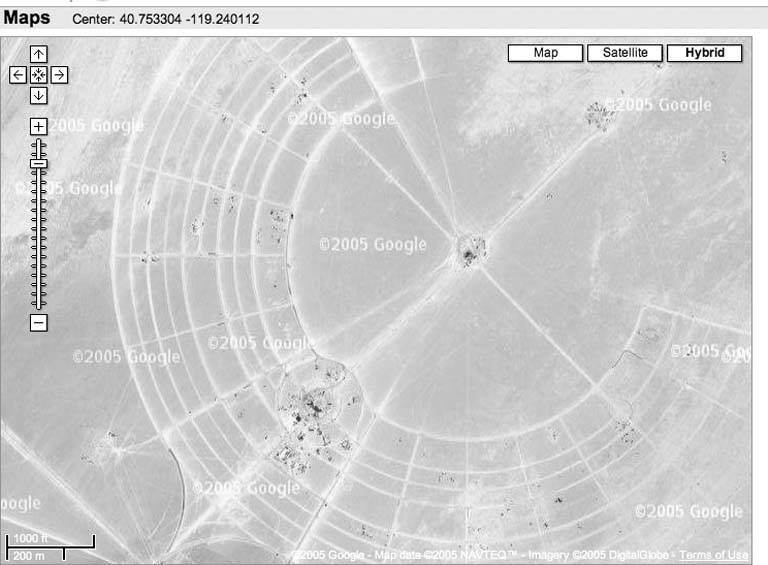
Figure 5-4 shows part of the Black Rock desert in Nevada, near the town of Gerlach. For most of the year this is an empty expanse where you can either hear yourself think or hear the people cruising about trying to set land-speed records in the armed-and-inebriated SUV-driving category. However, for a week, plus time before and after for set up and clean up, this is Black Rock City, home to the Burning Man festival. This particular image was taken during the setup period for the 2003 event.
Figure 5-4. A bit of desert in Nevada, late summer
How did that happen to become the canonical Google representation of an area around 40.7549 N, 119.23608 W? I suspect that it wasn't pure chance! Was it an accident that the aerial photo in Figure 5-5 centered around 37. 713532 N, 122.386075 W shows the San Francisco 49ers' football stadium near Candlestick Point State Park in the middle of a game?
On the other hand, the aerial photo in Figure 5-6 centered on 37.751367 N, -122.201239 W shows the nearby home of the Oakland Raiders, another football team, to be empty and configured for a baseball game??
The simplest explanation is that maps tell stories, and so these particular mapmakers configured reality through selection of imagery in order to tell a more entertaining story. After all, according to Muriel Rukeyser, "the universe is made up of stories, not atoms."
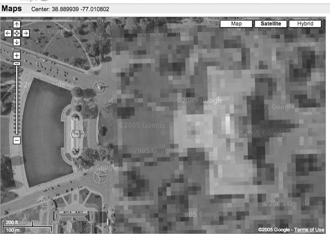
Some of the stories have a chilling message. Take a look at the imagery around 1600 Pennsylvania Avenue, Washington, D.C. You can count the trees on the White House grounds, but roofs are all obscured, as seen in Figure 5-7.
The White House suffers little in comparison to the Capitol. Clearly there is a large blobby thing at that end of the National Mall, but it isn't clear what it is. Congress is apparently more protective of its foliage than is the Executive Branch, as we can see in Figure 5-8.
Figure 5-5. Near Candlestick Point State Park
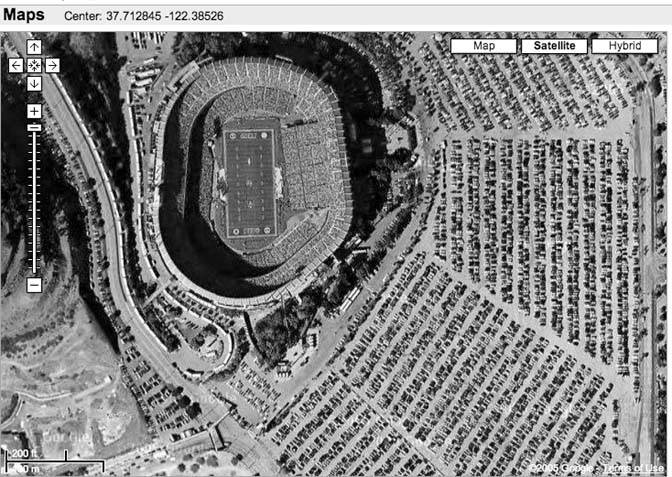
Figure 5-6. The home of the Raider Nation in Oakland
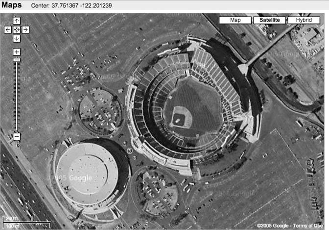
Figure 5-7. You can plan an Easter egg hunt, but don't plan to find any on the roof
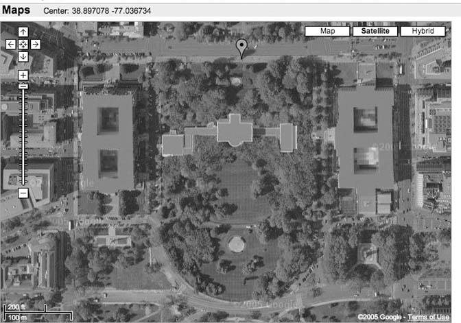
Figure 5-8. Congress shall make no law, assuming you can find it
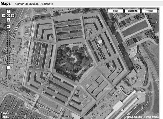
The Pentagon, as shown in Figure 5-9, appears to be the least protective of rooftop assets.
Figure 5-9. For once, the Pentagon appears to have nothing to hide
In some parts of the country, cornfield artists have expressed their support for the military. There are no obscured roofs in Figure 5-10, and I bet folks in uniform feel welcome in Bellevue, Nebraska. (At least, the ones who fly do!)
I'm tempted to make a comment about real national security versus "security theater," but there are so many strange things happening in the world that I don't understand that I'd best remain silent. At a recent conference, I was introduced to the phrase kill chain, as in "you can ignore him, he's not in the kill chain." Since I can't even figure out which Linux desktop is best, I have no chance at an intelligent opinion about national security or the kill chain.
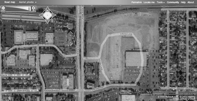
Perhaps I'm better equipped for an appreciation of the two images of 1 Infinite Loop, Cupertino, CA 95014. The first, Figure 5-11, is taken from Google's satellite imagery, and the second, Figure 5-12, from Microsoft's Virtual Earth.
Was Apple bombed to rubble recently? Obviously, as of this writing, Microsoft's Digital Earth is using very old imagery of a small slice of Cupertino. This appears odd, since the imagery for other parts of the Bay Area seems much more current. It's almost as if…Microsoft…wants us to believe…that Apple…simply isn't there….No, in the end, fretting over conspiracy theories about how places are portrayed is unsatisfying.
Figure 5-10. "We honor those who serve America"
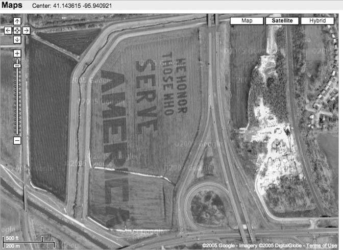
Figure 5-11. What Google thinks of this particular Infinite Loop
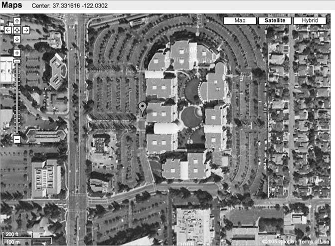
Figure 5-12. Apple appears to have disappeared
That doesn't make it necessarily wrong, however. After all, we live in a world where a telephone company with broadband business will intentionally block traffic to telecomm workers' union web sites during a strike. Perhaps it is enough to recognize the lesson that reality is a commodity, like any other, and that access to reality is sometimes mediated through more steps than might always be totally healthy for a free and democratic society.
You Are Here: Introducing Google Maps
- Hacks 19: Introduction
- Hack 1. Get Around http://maps.google.com
- Hack 2. Find Yourself (and Others) on Google Maps
- Hack 3. Navigate the World in Your Web Browser
- Hack 4. Get the Birds-Eye View
- Hack 5. Driven to a Better User Interface
- Hack 6. Share Google Maps
- Hack 7. Inside Google Maps URLs
- Hack 8. Generate Links to Google Maps in a Spreadsheet
- Hack 9. Use del.icio.us to Keep Up with Google Maps
Introducing the Google Maps API
- Hacks 1016: Introduction
- Hack 10. Add a Google Map to Your Web Site
- Hack 11. Where Did the User Click?
- Hack 12. How Far Is That? Go Beyond Driving Directions
- Hack 13. Create a Route with a Click (or Two)
- Hack 14. Create Custom Map Markers
- Hack 15. Map a Slideshow of Your Travels
- Hack 16. How Big Is the World?
Mashing Up Google Maps
- Hacks 1728: Introduction
- Hack 17. Map the News
- Hack 18. Examine Patterns of Criminal Activity
- Hack 19. Map Local Weather Conditions
- Hack 20. Track Official Storm Reporting
- Hack 21. Track the International Space Station
- Hack 22. Witness the Effects of a Nuclear Explosion
- Hack 23. Find a Place to Live
- Hack 24. Search for Events by Location
- Hack 25. Track Your UPS Packages
- Hack 26. Follow Your Packets Across the Internet
- Hack 27. Add Google Maps to Any Web Site
- Hack 28. How Big Is That, Exactly?
On the Road with Google Maps
- Hacks 2941: Introduction
- Hack 29. Find the Best Gasoline Prices
- Hack 30. Stay Out of Traffic Jams
- Hack 31. Navigate Public Transportation
- Hack 32. Locate a Phone Number
- Hack 33. Why Your Cell Phone Doesnt Work There
- Hack 34. Publish Your Own Hiking Trail Maps
- Hack 35. Load Driving Directions into Your GPS
- Hack 36. Get Driving Directions for More Than Two Locations
- Hack 37. View Your GPS Tracklogs in Google Maps
- Hack 38. Map Your Wardriving Expeditions
- Hack 39. Track Your Every Move with Google Earth
- Hack 40. The Ghost in Google Ride Finder
- Hack 41. How Google Maps Got Me Out of a Traffic Ticket
Google Maps in Words and Pictures
- Hacks 4250: Introduction
- Hack 42. Get More out of What You Read
- Hack 43. Dont Believe Everything You Read on a Map
- Hack 44. You Got Your A9 Local in My Google Maps!
- Hack 45. Share Pictures with Your Community
- Hack 46. Browse Photography by Shooting Location
- Hack 47. Geotag Your Own Photos on Flickr
- Hack 48. Tell Your Communitys Story
- Hack 49. Generate Geocoded RSS from Any Google Map
- Hack 50. Geoblog with Google Maps in Thingster
API Tips and Tricks
- Hacks 5161: Introduction
- Hack 51. Make a Fullscreen Map the Right Way
- Hack 52. Put a Map and HTML into Your Info Windows
- Hack 53. Add Flash Applets to Your Google Maps
- Hack 54. Add a Nicer Info Window to Your Map with TLabel
- Hack 55. Put Photographs on Your Google Maps
- Hack 56. Pin Your Own Maps to Google Maps with TPhoto
- Hack 57. Do a Local Zoom with GxMagnifier
- Hack 58. Find the Right Zoom Level
- Hack 59. Show Lots of StuffQuickly
- Hack 60. Make Things Happen When the Map Moves
- Hack 61. Use the Right Developers Key Automatically
Extreme Google Maps Hacks
- Hacks 6270: Introduction
- Hack 62. Find the Latitude and Longitude of a Street Address
- Hack 63. Read and Write Markers from a MySQL Database
- Hack 64. Build Custom Icons on the Fly
- Hack 65. Add More Imagery with a WMS Interface
- Hack 66. Add Your Own Custom Map
- Hack 67. Serve Custom Map Imagery
- Hack 68. Automatically Cut and Name Custom Map Tiles
- Hack 69. Cluster Markers at High Zoom Levels
- Hack 70. Will the Kids Barf? (and Other Cool Ways to Use Google Maps)
EAN: 2147483647
Pages: 131
