Hack 4. Get the Birds-Eye View
Hack 4 Get the Bird s Eye View


Maps are good, but a picture is worth…
Maps show what the mapmaker chooses to show. Google Maps, like most of the online map services, shows maps that are designed primarily for getting around in a car. In America, we pretend we've (d)evolved into homo automobilious, but despite our best efforts there is more to the world than scenery and billboards flying past the bug-smeared windshield.
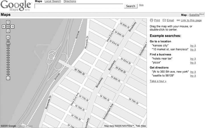
One neat feature of Google Maps is the ability to flip between viewing a map and viewing satellite imagery. In Figure 1-8 we see a map of the Upper West Side of Manhattan, with an odd little shape sticking into the Hudson River on the left side. By clicking on the Satellite link on the upper-right side of the window, you get satellite and aerial imagery.
Figure 1-8. Upper West Side Manhattan
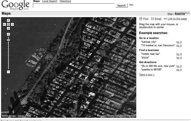
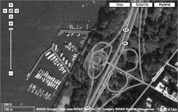
The aerial view in Figure 1-9 provides a lot more context! You can see the buildings and Riverside Drive. You can even make out individual boats at the 79th Street Boat Basin. You can use the same navigation tricks to pan around in satellite and aerial imagery as you can on the map layer [Hack #3].
Figure 1-9. Aerial view of the Upper West Side and the 79th Street Boat Basin
The satellite imagery's level of detail varies by where you're looking; some places have much more detail than others.
1.5.1. Is It Really There?
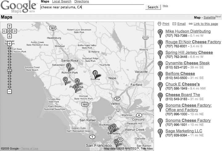
You can use the aerial imagery as a sanity check. For example, let's say you are in the North Bay area and are interested in dairy products. You could search for cheese near Petaluma, CA and get a map like Figure 1-10.
Figure 1-10. Looking for cheese in all the wrong places
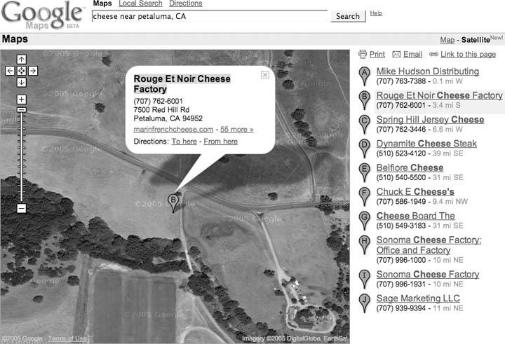
To visit Rouge et Noir Cheese Factory (http://www.marinfrenchcheese.com/), you could click on the link on the right side in the list of results, zoom in a bit, and flip to satellite view to get the view in Figure 1-11.
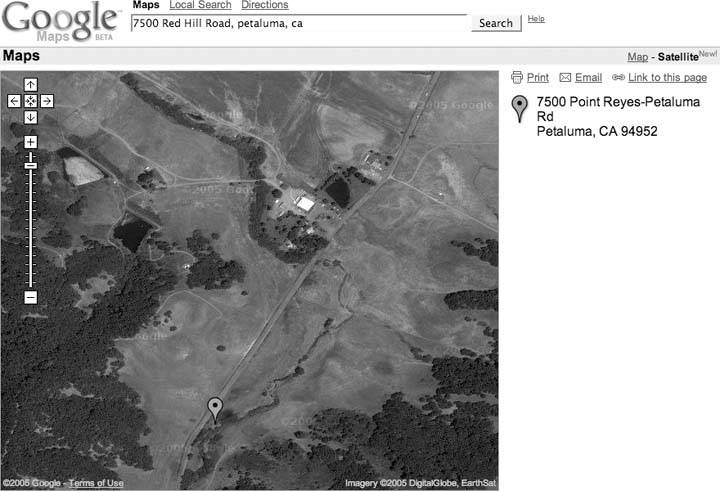
Where's the cheese? It doesn't look like it is there. Could it be in that circular compound on the right-hand side? Maybe, except I happen to know that this isn't the case. It seems that there's a disconnect between databases at Google. The business listing for Rouge et Noir puts it at 7500 Red Hill Road, Petaluma, CA 94952, but the map pointer is 4.5 miles northeast. Of course, this is beta software!
Entering the address, rather than the business name, into the search box rewrites the address as 7500 Point ReyesPetaluma Rd and comes closer to locating the Cheese Factory, as shown in Figure 1-12. The pointer is still a bit off, but that can be attributed to the difficulty in geocoding locations from street addresses on roads with long patches between intersections.
Figure 1-11. Cheeseless in Marin
|

Figure 1-12. Thar be cheese!
1.5.2. Hybrid Vigor
Now, as if that weren't enough, Google has added a Hybrid mode to Google Maps. The Hybrid mode takes a version of the original street map tiles with transparent backgrounds, and then lays them over the satellite tiles. The result is pretty fantastic, as you can see from Figure 1-13, making it much easier to identify what's being shown in the satellite image.
Figure 1-13. Manhattan's Upper West Side, in Hybrid mode
The ability to flip between maps and satellite imagery is amazingly cool, and is just a hint of what (I assume) is coming. There is plenty of room next to the Map, Satellite, and Hybrid hyperlinks for other views or, as we say in Geographic Information Systems, other data layers. One prominent example was the Katrina button that showed up in the map display of the Gulf Coast of the United States in the aftermath of Hurricane Katrina in August 2005. Clicking this button displayed up-to-date satellite imagery, allowing you to compare before-and-after views of the hurricane's tragically destructive wake.
What could Google add? How about a link to terrain or elevation data? Or a current weather overlay? Thanks, Google, may I have another?
You Are Here: Introducing Google Maps
- Hacks 19: Introduction
- Hack 1. Get Around http://maps.google.com
- Hack 2. Find Yourself (and Others) on Google Maps
- Hack 3. Navigate the World in Your Web Browser
- Hack 4. Get the Birds-Eye View
- Hack 5. Driven to a Better User Interface
- Hack 6. Share Google Maps
- Hack 7. Inside Google Maps URLs
- Hack 8. Generate Links to Google Maps in a Spreadsheet
- Hack 9. Use del.icio.us to Keep Up with Google Maps
Introducing the Google Maps API
- Hacks 1016: Introduction
- Hack 10. Add a Google Map to Your Web Site
- Hack 11. Where Did the User Click?
- Hack 12. How Far Is That? Go Beyond Driving Directions
- Hack 13. Create a Route with a Click (or Two)
- Hack 14. Create Custom Map Markers
- Hack 15. Map a Slideshow of Your Travels
- Hack 16. How Big Is the World?
Mashing Up Google Maps
- Hacks 1728: Introduction
- Hack 17. Map the News
- Hack 18. Examine Patterns of Criminal Activity
- Hack 19. Map Local Weather Conditions
- Hack 20. Track Official Storm Reporting
- Hack 21. Track the International Space Station
- Hack 22. Witness the Effects of a Nuclear Explosion
- Hack 23. Find a Place to Live
- Hack 24. Search for Events by Location
- Hack 25. Track Your UPS Packages
- Hack 26. Follow Your Packets Across the Internet
- Hack 27. Add Google Maps to Any Web Site
- Hack 28. How Big Is That, Exactly?
On the Road with Google Maps
- Hacks 2941: Introduction
- Hack 29. Find the Best Gasoline Prices
- Hack 30. Stay Out of Traffic Jams
- Hack 31. Navigate Public Transportation
- Hack 32. Locate a Phone Number
- Hack 33. Why Your Cell Phone Doesnt Work There
- Hack 34. Publish Your Own Hiking Trail Maps
- Hack 35. Load Driving Directions into Your GPS
- Hack 36. Get Driving Directions for More Than Two Locations
- Hack 37. View Your GPS Tracklogs in Google Maps
- Hack 38. Map Your Wardriving Expeditions
- Hack 39. Track Your Every Move with Google Earth
- Hack 40. The Ghost in Google Ride Finder
- Hack 41. How Google Maps Got Me Out of a Traffic Ticket
Google Maps in Words and Pictures
- Hacks 4250: Introduction
- Hack 42. Get More out of What You Read
- Hack 43. Dont Believe Everything You Read on a Map
- Hack 44. You Got Your A9 Local in My Google Maps!
- Hack 45. Share Pictures with Your Community
- Hack 46. Browse Photography by Shooting Location
- Hack 47. Geotag Your Own Photos on Flickr
- Hack 48. Tell Your Communitys Story
- Hack 49. Generate Geocoded RSS from Any Google Map
- Hack 50. Geoblog with Google Maps in Thingster
API Tips and Tricks
- Hacks 5161: Introduction
- Hack 51. Make a Fullscreen Map the Right Way
- Hack 52. Put a Map and HTML into Your Info Windows
- Hack 53. Add Flash Applets to Your Google Maps
- Hack 54. Add a Nicer Info Window to Your Map with TLabel
- Hack 55. Put Photographs on Your Google Maps
- Hack 56. Pin Your Own Maps to Google Maps with TPhoto
- Hack 57. Do a Local Zoom with GxMagnifier
- Hack 58. Find the Right Zoom Level
- Hack 59. Show Lots of StuffQuickly
- Hack 60. Make Things Happen When the Map Moves
- Hack 61. Use the Right Developers Key Automatically
Extreme Google Maps Hacks
- Hacks 6270: Introduction
- Hack 62. Find the Latitude and Longitude of a Street Address
- Hack 63. Read and Write Markers from a MySQL Database
- Hack 64. Build Custom Icons on the Fly
- Hack 65. Add More Imagery with a WMS Interface
- Hack 66. Add Your Own Custom Map
- Hack 67. Serve Custom Map Imagery
- Hack 68. Automatically Cut and Name Custom Map Tiles
- Hack 69. Cluster Markers at High Zoom Levels
- Hack 70. Will the Kids Barf? (and Other Cool Ways to Use Google Maps)
EAN: 2147483647
Pages: 131
