Hack 50. Geoblog with Google Maps in Thingster


Share your favorite places with friends.
In this hack, I discuss our Thingster Geoblogging service and some of the details of how I integrated Google Maps. We provide Thingster free of charge at http://www.thingster.org/, and it is open source and open data licensed as well. You're welcome to log in, create an account, and play with it; you're also welcome to run your own copy or just take any ideas you like and build your own equivalent.
My own interest in place-tagging came from a very simple desire: I wanted to be able to share information about my favorite places with my friends. The fact that there are not 10,000 companies already doing this has always completely mystified me. It seemed like a perfectly logical business plan if you were so mindedcertainly better than, say, "pets.com."
It is pretty obvious that the blogging paradigm is the right way to hang Post-It notes in space. People already use blogs in almost exactly this way: you own your own blog, you publish in a formal publishing framework, and blogs export this wonderful RSS format that is machine-readable. Blogs have already been extended to blog pictures, songs, and even video: blogging by location is the next logical step.
The challenge in blogging about places is that our blogging tools or content management systems need to support some kind of satisfying, fast, and compelling map interface. These tools need to be as easy to use as ordinary blogging tools. A clever novice should be able to walk up to a mapping service, create an account, and post her first geotagged post in under a minute.
5.10.1. Enter Thingster
In 2004, Ben Russell and I first conceived Thingster as an "anything tool," where one could blog about any kind of thing. Maps were the first clear interest and my good friends Tom Longson and Brad Degraf quickly jumped on board to help play with the idea. We thought that if community driven maps existed, then we could start to share information about our communities more intelligently, and that this might even change the way we engage and interact as citizens. This is the sort of big if that always seems to be a warning of several months of sleepless nights hacking.
Let me point out that those of you who haven't had to suffer in the dark ages before Google Maps simply have no appreciation of how hard it was to build a compelling web mapping service. It was uphill with snowstorms both ways and we had to arrive before we left. We had tried several other mapping solutions that were available in the open source community and I even personally did try to build my own mapserver (which is available at http://maps.civicactions.net). The labour, time, and ultimate performance of rolling our own is completely humbling. We recognized just how high the bar is set in what users expect from a web mapping service.
Today Google Maps provides us with that last missing piece, and not only is Thingster finally able to articulate its vision, but several other exciting projects, such as http://ning.com, http://platial.com, and http://tagzania.com are also rapidly beginning to explore the possibilities of easy access to a compelling web mapping service.
5.10.2. Adding Maps to Blogs
In the development of my own approach it became obvious that there are several key things that map-based content management systems should do:
- They should use tags in a way similar to the notable http://del.icio.us project. Organizing place information seems to be so difficult otherwise.
- "Post to Map" is crucial. People want to interact with a map when they make a post, not try to enter a street address or a longitude/latitude pair by hand.
- There should be an opportunity to post a comment with regards to a previously placed post. Rather than ending up with a cloud of posts around a restaurant or a swimming hole, it is important to let people use discovery first to prevent clutter.
- There must be extensive pivots. One should be able to examine a location and see all the comments about that place. Or to then look at an author of a particular comment and see other posts that author might have made about other locations. Mapping seems to often imply relationships to the other people who have that same interest; it makes sense to find ways to create synergy.
- The mapping service has to be fast and lightweight overall. Google Maps more than delivers on this.
5.10.3. Practice
Connecting Google Maps to a blogging tool requires connecting both an input side and an output side. You want to both capture Google Maps position information for new posts, and you want to plot posts to Google Maps when you are viewing the blog.
On the input side, I connected the Google Maps navigation to the form input box. As you drag Google Maps around, it instantly updates the user input form box so that when the user finally submits the post, the post has the map location that they have suggested. This code was quite a small bit of JavaScript, and it looked something like this:
	var map = null;
	map = new GMap(mapdiv);
	map.addControl(new GSmallMapControl());
	map.centerAndZoom(new GPoint(-123,45), 6);

	// REGISTER CHANGES INTO FORM IF FORM EXISTS

	GEvent.addListener(map, "moveend", function() {
	 var center = map.getCenterLatLng();
	 var latLngStr = center.y + ' ' + center.x;
	 if( parent.document.form && parent.document.form.locationinput ) {
	 parent.document.form.locationinput.value = latLngStr;
	 }
	});
On the output side, when I want to plot the points in my content management system to Google Maps, I request an RSS feed of the particular channel that the user wants to plot and simply plot those points. That code is slightly larger because it has to fetch an XML document from the server (the RSS feed), walk through it, and post those posts into Google Maps. You can use the GXmlHttp class from the Google Maps API as a means of fetching this data on the fly, without having to worry about browser compatibility issues.
Once I have one of my RSS feeds with some geo-data in it, I instruct Google Maps to plot each of the points:
	// ITERATE ITEMS - BUILD MAP WHEN NEEDED

	var latmin = 0;
	var latmax = 0;
	var lonmin = 0;
	var lonmax = 0;
	var visited = 0;

	for(var content = data.firstChild; content != null; content =
	 content.nextSibling ) {

	 if( content.nodeName != 'item' ) {
	 continue;
	 }

	 // get some stuff
	 var title = getfield(content,"dc:title");
	 var link = getfield(content,"dc:link");
	 var description = getfield(content,"dc:description");
	 var location = getfield(content,"th:location");
	 if(!location || location.length < 2) {
	 continue;
	 }

	 var strs = location.split(" ");
	 var a = strs[0];
	 var b = strs[1];
	 if( a.indexOf('(')>=0) {
	 continue;
	 }

	 var lat = 0;
	 var lon = 0;
	 try {
	 lat = parseFloat( a );
	 lon = parseFloat( b );
	 } catch(e) {
	 continue;
	 }
	 a = "" + lat;
	 b = "" + lon;
	 if( a == 'undefined' || a == "NaN" ) continue;
	 if( b == 'undefined' || b == "NaN" ) continue;
	 if( lon == 0 && lat == 0 ) {
	 continue;
	 }
	 a = 1234;

	 // bounds builder
	 if( visited == 0 ) {
	 latmin = latmax = lat;
	 lonmin = lonmax = lon;
	 } else {
	 if( latmin > lat ) latmin = lat;
	 if( latmax < lat ) latmax = lat;
	 if( lonmin > lon ) lonmin = lon;
	 if( lonmax < lon ) lonmax = lon;
	 }
	 var point = new GPoint(lon,lat);
	 var marker = new GMarker(point);
	 var html = title;
	 GEvent.addListener(marker,"click",function() {
	 marker.openInfoWindowHtml(html);
	 } );
	 map.addOverlay(marker);
	 visited++;
	 }
	 var latc = latmin + (latmax - latmin) / 2;
	 var lonc = lonmin + (lonmax - lonmin) / 2;
	 // should pick zoom better some year
	 map.centerAndZoom(new GPoint(lonc,latc), 13);
	}
5.10.4. How Do You Actually Use Thingster?
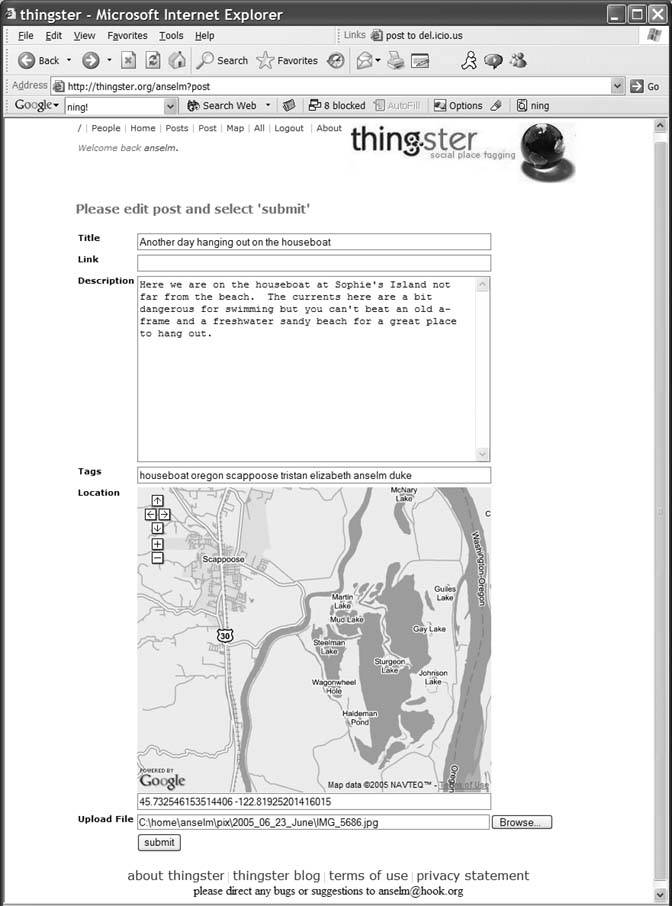
In Thingster, you first create an account and log in using the register page at http://thingster.org/register. Once you are in your home page, you can select "post" to create a new post. The post form allows image upload and has an integrated map, as shown in Figure 5-28.
Figure 5-28. Thingster image upload with integrated map
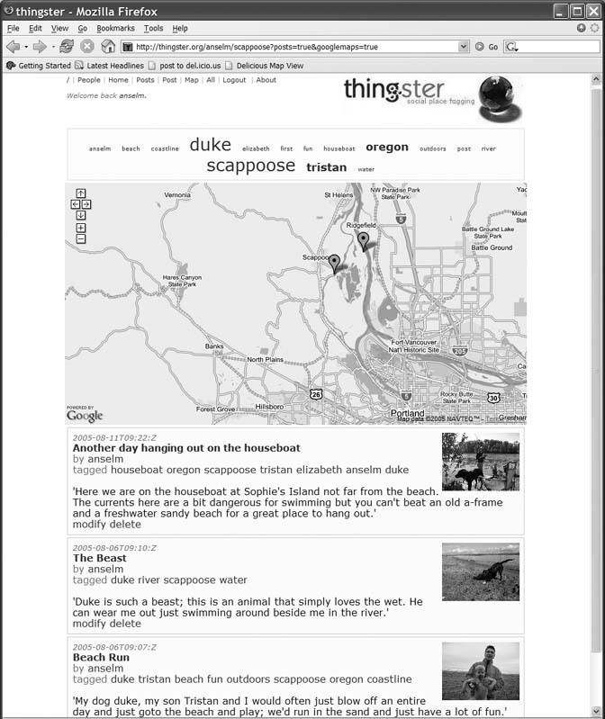
When you are done posting, return to your home page, where you can see a compilation of your posts and pictures on a map, as depicted in Figure 5-29.
Figure 5-29. Thingster's compilation of your posts and pictures on a map
Having Google Maps in Thingster lets us explore a number of tasty implications we originally thought might exist. Better maps affect what we see, the choices we make, the repercussions of those decisions, and perhaps even the shape of our societies. Our goal in providing this service is to explore such ideas.
Anselm Hook
You Are Here: Introducing Google Maps
- Hacks 19: Introduction
- Hack 1. Get Around http://maps.google.com
- Hack 2. Find Yourself (and Others) on Google Maps
- Hack 3. Navigate the World in Your Web Browser
- Hack 4. Get the Birds-Eye View
- Hack 5. Driven to a Better User Interface
- Hack 6. Share Google Maps
- Hack 7. Inside Google Maps URLs
- Hack 8. Generate Links to Google Maps in a Spreadsheet
- Hack 9. Use del.icio.us to Keep Up with Google Maps
Introducing the Google Maps API
- Hacks 1016: Introduction
- Hack 10. Add a Google Map to Your Web Site
- Hack 11. Where Did the User Click?
- Hack 12. How Far Is That? Go Beyond Driving Directions
- Hack 13. Create a Route with a Click (or Two)
- Hack 14. Create Custom Map Markers
- Hack 15. Map a Slideshow of Your Travels
- Hack 16. How Big Is the World?
Mashing Up Google Maps
- Hacks 1728: Introduction
- Hack 17. Map the News
- Hack 18. Examine Patterns of Criminal Activity
- Hack 19. Map Local Weather Conditions
- Hack 20. Track Official Storm Reporting
- Hack 21. Track the International Space Station
- Hack 22. Witness the Effects of a Nuclear Explosion
- Hack 23. Find a Place to Live
- Hack 24. Search for Events by Location
- Hack 25. Track Your UPS Packages
- Hack 26. Follow Your Packets Across the Internet
- Hack 27. Add Google Maps to Any Web Site
- Hack 28. How Big Is That, Exactly?
On the Road with Google Maps
- Hacks 2941: Introduction
- Hack 29. Find the Best Gasoline Prices
- Hack 30. Stay Out of Traffic Jams
- Hack 31. Navigate Public Transportation
- Hack 32. Locate a Phone Number
- Hack 33. Why Your Cell Phone Doesnt Work There
- Hack 34. Publish Your Own Hiking Trail Maps
- Hack 35. Load Driving Directions into Your GPS
- Hack 36. Get Driving Directions for More Than Two Locations
- Hack 37. View Your GPS Tracklogs in Google Maps
- Hack 38. Map Your Wardriving Expeditions
- Hack 39. Track Your Every Move with Google Earth
- Hack 40. The Ghost in Google Ride Finder
- Hack 41. How Google Maps Got Me Out of a Traffic Ticket
Google Maps in Words and Pictures
- Hacks 4250: Introduction
- Hack 42. Get More out of What You Read
- Hack 43. Dont Believe Everything You Read on a Map
- Hack 44. You Got Your A9 Local in My Google Maps!
- Hack 45. Share Pictures with Your Community
- Hack 46. Browse Photography by Shooting Location
- Hack 47. Geotag Your Own Photos on Flickr
- Hack 48. Tell Your Communitys Story
- Hack 49. Generate Geocoded RSS from Any Google Map
- Hack 50. Geoblog with Google Maps in Thingster
API Tips and Tricks
- Hacks 5161: Introduction
- Hack 51. Make a Fullscreen Map the Right Way
- Hack 52. Put a Map and HTML into Your Info Windows
- Hack 53. Add Flash Applets to Your Google Maps
- Hack 54. Add a Nicer Info Window to Your Map with TLabel
- Hack 55. Put Photographs on Your Google Maps
- Hack 56. Pin Your Own Maps to Google Maps with TPhoto
- Hack 57. Do a Local Zoom with GxMagnifier
- Hack 58. Find the Right Zoom Level
- Hack 59. Show Lots of StuffQuickly
- Hack 60. Make Things Happen When the Map Moves
- Hack 61. Use the Right Developers Key Automatically
Extreme Google Maps Hacks
- Hacks 6270: Introduction
- Hack 62. Find the Latitude and Longitude of a Street Address
- Hack 63. Read and Write Markers from a MySQL Database
- Hack 64. Build Custom Icons on the Fly
- Hack 65. Add More Imagery with a WMS Interface
- Hack 66. Add Your Own Custom Map
- Hack 67. Serve Custom Map Imagery
- Hack 68. Automatically Cut and Name Custom Map Tiles
- Hack 69. Cluster Markers at High Zoom Levels
- Hack 70. Will the Kids Barf? (and Other Cool Ways to Use Google Maps)
EAN: 2147483647
Pages: 131
- Article 220 Branch-Circuit, Feeder, and Service Calculations
- Article 384 Strut-Type Channel Raceway
- Article 402: Fixture Wires
- Article 426: Fixed Outdoor Electric De-Icing and Snow-Melting Equipment
- Example No. D2(b) Optional Calculation for One-Family Dwelling, Air Conditioning Larger than Heating [See 220.82(A) and 220.82(C)]
