Hack 45. Share Pictures with Your Community


Use Flickrcity to set up a collaborative photo map.
Putting geolocated photos on a map is something geo-hackers have worked on for a long time. Now, using Flickr, Google Maps, and a little piece of glue called Flickrcity (http://anti-mega.com/flickrcity/), anyone can do this easily.
I started work on Flickrcity because I wanted to create a restaurant review site for Helsinki that anyone could contribute to. Flickr was the natural place to store photos and information; sites such as Geobloggers (http://www.geobloggers.com/) were using Flickr as a data source and had already created a standard for geotagging photos.
Flickrcity automatically filters on a tag of the name of the city and the tag geotagged. Using additional tags, or specifying a particular user, you can use Flickrcity for a variety of purposes.
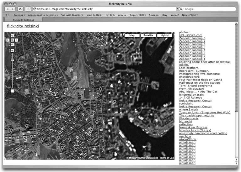
To see all geotagged photos in a city, you can just go to the URL of the Flickrcity installatione.g., for Helsinki, http://anti-mega.com/flickrcity/helsinki.city, as shown in Figure 5-15.
Figure 5-15. Photos geotagged in Helsinki
If you wanted to set up a collaborative restaurant review site for Helsinki, you would need to tag photos in Flickr with, say, "helsinki," "food," "geotagged," and the two location geotags [Hack #46]. Then you would construct a URL that would return these images with this tag query, such as http://anti-mega.com/flickrcity/helsinki.city?tags=food. Figure 5-16 shows what this looks like.
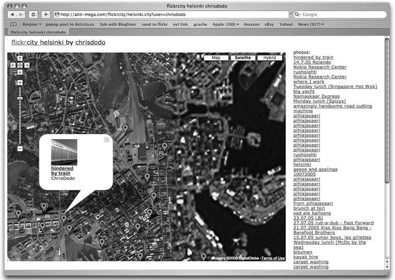
If you just wanted to see all of my Helsinki photos, you would use a user query such as http://anti-mega.com/flickrcity/helsinki.city?user=chrisdodo, as Figure 5-17 demonstrates.
Of course, you can combine the two, to show just my food photos, as in http://anti-mega.com/flickrcity/helsinki.city?tags=food&user=chrisdodo.
If you're using the map for yourself, use a different tag for each project you want to create. If you want to set up a collaborative map, pick a tag name that isn't being used in Flickr and tell all your photographers to add that tag. Of course, others may see it and start using the tag tooFlickrcity gets even better with more geotagged photos.
I've set up Flickrcity installations for a few cities, and others have set up even more, but you can also download the code and set up Flickrcity for wherever you want. To do this, you will need a web server with Perl, some Perl modules (see the installation instructions on the web page for the list), and a little bit of webmaster knowledge.
Figure 5-16. Photos tagged with food in Helsinki
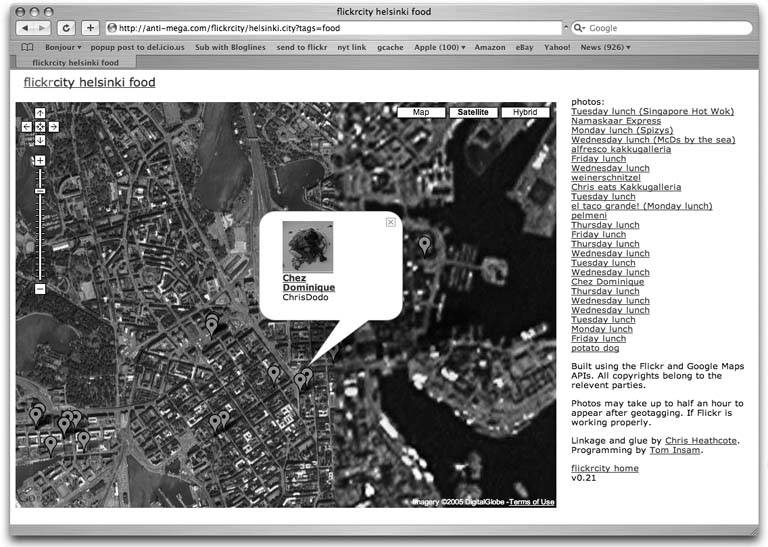
Figure 5-17. Photos taken by chrisdodo in Helsinki
You will need to change a few things in the script (mainly the name of the city and the default Google map coordinates and zoom level), and a directory on the server to store cache files. Then put the script in a directory on your server suitable for housing CGI scripts, make the script executable, and it should work.
The script relies on the Flickr and Google Maps APIs, and if either service is slow or down, there may be problems. The first time you run the script, it will create a cache of data from Flickr, which will be slow, but it will run more quickly after that.
Chris Heathcote
You Are Here: Introducing Google Maps
- Hacks 19: Introduction
- Hack 1. Get Around http://maps.google.com
- Hack 2. Find Yourself (and Others) on Google Maps
- Hack 3. Navigate the World in Your Web Browser
- Hack 4. Get the Birds-Eye View
- Hack 5. Driven to a Better User Interface
- Hack 6. Share Google Maps
- Hack 7. Inside Google Maps URLs
- Hack 8. Generate Links to Google Maps in a Spreadsheet
- Hack 9. Use del.icio.us to Keep Up with Google Maps
Introducing the Google Maps API
- Hacks 1016: Introduction
- Hack 10. Add a Google Map to Your Web Site
- Hack 11. Where Did the User Click?
- Hack 12. How Far Is That? Go Beyond Driving Directions
- Hack 13. Create a Route with a Click (or Two)
- Hack 14. Create Custom Map Markers
- Hack 15. Map a Slideshow of Your Travels
- Hack 16. How Big Is the World?
Mashing Up Google Maps
- Hacks 1728: Introduction
- Hack 17. Map the News
- Hack 18. Examine Patterns of Criminal Activity
- Hack 19. Map Local Weather Conditions
- Hack 20. Track Official Storm Reporting
- Hack 21. Track the International Space Station
- Hack 22. Witness the Effects of a Nuclear Explosion
- Hack 23. Find a Place to Live
- Hack 24. Search for Events by Location
- Hack 25. Track Your UPS Packages
- Hack 26. Follow Your Packets Across the Internet
- Hack 27. Add Google Maps to Any Web Site
- Hack 28. How Big Is That, Exactly?
On the Road with Google Maps
- Hacks 2941: Introduction
- Hack 29. Find the Best Gasoline Prices
- Hack 30. Stay Out of Traffic Jams
- Hack 31. Navigate Public Transportation
- Hack 32. Locate a Phone Number
- Hack 33. Why Your Cell Phone Doesnt Work There
- Hack 34. Publish Your Own Hiking Trail Maps
- Hack 35. Load Driving Directions into Your GPS
- Hack 36. Get Driving Directions for More Than Two Locations
- Hack 37. View Your GPS Tracklogs in Google Maps
- Hack 38. Map Your Wardriving Expeditions
- Hack 39. Track Your Every Move with Google Earth
- Hack 40. The Ghost in Google Ride Finder
- Hack 41. How Google Maps Got Me Out of a Traffic Ticket
Google Maps in Words and Pictures
- Hacks 4250: Introduction
- Hack 42. Get More out of What You Read
- Hack 43. Dont Believe Everything You Read on a Map
- Hack 44. You Got Your A9 Local in My Google Maps!
- Hack 45. Share Pictures with Your Community
- Hack 46. Browse Photography by Shooting Location
- Hack 47. Geotag Your Own Photos on Flickr
- Hack 48. Tell Your Communitys Story
- Hack 49. Generate Geocoded RSS from Any Google Map
- Hack 50. Geoblog with Google Maps in Thingster
API Tips and Tricks
- Hacks 5161: Introduction
- Hack 51. Make a Fullscreen Map the Right Way
- Hack 52. Put a Map and HTML into Your Info Windows
- Hack 53. Add Flash Applets to Your Google Maps
- Hack 54. Add a Nicer Info Window to Your Map with TLabel
- Hack 55. Put Photographs on Your Google Maps
- Hack 56. Pin Your Own Maps to Google Maps with TPhoto
- Hack 57. Do a Local Zoom with GxMagnifier
- Hack 58. Find the Right Zoom Level
- Hack 59. Show Lots of StuffQuickly
- Hack 60. Make Things Happen When the Map Moves
- Hack 61. Use the Right Developers Key Automatically
Extreme Google Maps Hacks
- Hacks 6270: Introduction
- Hack 62. Find the Latitude and Longitude of a Street Address
- Hack 63. Read and Write Markers from a MySQL Database
- Hack 64. Build Custom Icons on the Fly
- Hack 65. Add More Imagery with a WMS Interface
- Hack 66. Add Your Own Custom Map
- Hack 67. Serve Custom Map Imagery
- Hack 68. Automatically Cut and Name Custom Map Tiles
- Hack 69. Cluster Markers at High Zoom Levels
- Hack 70. Will the Kids Barf? (and Other Cool Ways to Use Google Maps)
EAN: 2147483647
Pages: 131
