So, Whats a Mapplet, Anyway?
So, What’s a Mapplet, Anyway?
The mapplet project is a mapping application—a hotel-finder street map that is hosted on our favorite travel website (okay, it’s Doug’s site). As a reader, you’ll have the opportunity to read through the use cases, look at the sequence and class diagrams, and interact with the application.
As you’ve probably gathered from the title of this chapter, our nickname for the example project is “mapplet,” even though it’s not really a Java applet. We apologize most profusely for confusing our readership, but the name just sort of stuck and now we’re used to it …
This being a book about agile development, we didn’t write a 500-page requirements document before coding, but instead “grew” the mapplet a few use cases at a time as a series of small releases. Over the various chapters of this book, you’ll learn how the design evolved across these releases. You’ll see some design errors that we corrected before coding, you’ll see how (and if) the code matches the design, and you’ll see how the actual running program matches the use cases we started with (aka use case–driven acceptance testing).
Just for fun (and to enhance the real-world flavor of the example), the mapplet was built with a brand-new (still in beta as this paragraph is being written) version of the GIS server software,[3.] and it was thus the first experience the development team had with this new server product. So, you’ll see some exploratory coding to figure out how the beta software fits into the process as well.
The core technology being used by the mapplet is a map server product called ArcGIS Server, from ESRI.ArcGIS[5.] is a platform for building enterprise GIS applications.
At its core, a GIS is a system for the management, analysis, and display of geographic information. Geographic information is represented by a series of geographic datasets that model geographic information using generic data structures. A GIS includes a set of comprehensive tools for maintaining geographic data, visualizing geographic data, and analyzing relationships between geographic features on the earth’s surface. Various map views of the underlying geographic information can be constructed and used as windows into the database to support queries, analysis, and editing of the information.
ArcGIS is used by thousands of different organizations and hundreds of thousands of individuals to access and manage a massive variety of geographic information.There are a number of books available that cover the ArcGIS suite of products, most notably Getting to Know ArcGIS Desktop,[6.] Mastering ArcGIS,[7.] and Getting to Know ArcObjects.[8.] Also, a particularly nice book on GIS science in general (not specifically about ArcGIS) is Geographic Information Systems and Science.[9.]
ArcGIS solves a particularly difficult challenge: representing in digital form a model of geographic information such as the earth’s surface; breaking these aspects down into a database of specific searchable features, such as cities, landmarks, or (in our case) hotels; and mapping addresses and zip codes to geospatial coordinates (and vice versa).
ArcGIS Server is the enterprise server of the ArcGIS platform, which includes a shared library of GIS software objects to build server-side GIS applications in an enterprise and web computing framework. ArcGIS Server provides the ability to publish GIS web services. It’s a platform for building enterprise GIS applications that are centrally managed, support multiple users, and include advanced GIS functionality. ArcGIS Server manages geographic resources, such as maps, locators, and GIS software objects, for use by applications.
Developers can use ArcGIS Server to build focused web applications, web services, and other enterprise applications, including those based on J2EE or .NET. Developers can use ArcGIS Server to build desktop applications that interact with the server in client/server mode.ArcGIS Server also supports out-of-the-box use by ArcGIS desktop applications for server administration, simple mapping, and geocoding over a local area network (LAN) or the Internet.
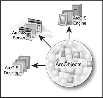
ArcGIS Server, like the entire ArcGIS system, is built and extended using software components called ArcObjects, as shown here:

The ArcGIS Server ArcObjects are the same ArcObjects that are at the core of all the ArcGIS products: ArcGIS Desktop, ArcGIS Engine, and ArcGIS Server.
ArcGIS Server consists of two primary components: a GIS server and an Application Development Framework (ADF) for .NET and Java. The GIS server hosts ArcObjects for use by web, enterprise, and desktop applications. It includes the core ArcObjects libraries and provides a scalable environment for running ArcObjects on a server.ADF allows you to build and deploy .NET or Java desktop and web applications that use ArcObjects running within the GIS server.
ADF includes a software developer kit (SDK) with software objects, web controls, web application templates, developer help, and code samples. It also includes a web application runtime, which allows you to deploy web applications without having to install ArcObjects on your web server.
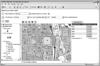
The following image is an example screenshot of an ArcGIS Server–based web application:

[3.]ArcGIS Server is now a fully released product. The first release of ArcGIS Server came with the release of the ArcGIS 9.0 software suite in May 2004. The mapplet development occurred on a beta release for the software; however, the final installation was released using ArcGIS 9.0.
[4.]Thanks to the ESRI marketing department and to Dave Lewis of ESRI for providing us with material for this section.
[5.]See www.esri.com/software/arcgis.
[6.]Tim Ormsby, Eileen Napoleon, Robert Burke, Carolyn Groessl, and Laura Feaster, Getting to Know ArcGIS Desktop: The Basics of ArcView, ArcEditor, and ArcInfo Updated for ArcGIS 9 (Redlands, CA: ESRI Press, June 2004).
[7.]Maribeth Price, Mastering ArcGIS (New York: McGraw-Hill, September 2003).
[8.]Robert Burke, Getting to Know ArcObjects (Redlands, CA: ESRI Press, October 2003).
[9.]Paul A. Longley, Michael F. Goodchild, David J. Maguire, and David W. Rhind, Geographic Information Systems and Science (West Sussex, England: John Wiley & Sons, August 2001).
EAN: 2147483647
Pages: 97