A.3. Map Projection Examples
| < Day Day Up > |
| The examples in the following section are based on some global map data that is stored in the Geographic Coordinate System. Each example is one projection at a suitable scale. This section is intended to introduce a few of the more common types of map projections and provide a picture of what they look like. Some brief description is provided, but other books and documents are recommended for learning more about these projections. The specific MapServer projection settings are included for reference. As long as all your layers have a valid projection set for them, these example projection settings can be used to change the output map projection.
A.3.1. Simple Cylindrical ProjectionFigure A-6 shows the most basic world map. The global coordinates, latitudes, and longitudes are displayed on a rectangular grid. Each rectangle is the same size on both x and y planes. This is the default projection used with MapServer when you specify the latlong projection. It is commonly known as a Simple Cylindrical projection, more technically known as Plate Carré. It is from the family of Equidistant Cylindrical projections. See the other references listed at the end of this chapter for more information about these types of projections. This projection is most useful near the equator because the features are distorted as you move away from the equator. The features of Antarctica in Figure A-6 are a good example of how distorted it can be. Figure A-6. Global map using a Simple Cylindrical projection A.3.1.1 MapServer syntaxSpecifying this projection is easy. All you need to set is the projection name and ellipsoid: PROJECTION "proj=latlong" "ellps=WGS84" END or: "init=epsg:4326" The extents of this map are set to: EXTENT -180 -90 180 90 A.3.2. Orthographic ProjectionFigure A-7 shows an example of the orthographic projection mentioned earlier. This projection has some popular appeal because it makes the map look like a globe. Figure A-7. Map of the Eastern Hemisphere using orthographic projection A.3.2.1 MapServer syntaxThe projection name is shortened to ortho. Specify a lat_0 and lon_0 to center the map on a particular latitude and longitude, respectively. PROJECTION "proj=ortho" "lat_0=45" "lon_0=45" "ellps=WGS84" END The extents of this map are set in meter units: EXTENT -8710000 -2739000 8710000 4493000 The extents are set to be wider than the earth (extents are 17,420 km wide) so you can see the curvature of the sphere. They aren't set to be taller than the earth, so the north and south portions are cut off.
A.3.3. Mercator ProjectionFigure A-8 shows an example of the Mercator projection which may appear common to many. It is most useful near the equator. As you can see, the grid isn't regular looking and it isn't possible to map the northern extremes accurately. Figure A-8. Example map showing northern latitudes in Mercator projection A.3.3.1 MapServer syntaxThe projection name is shortened to merc: PROJECTION "proj=merc" "ellps=WGS84" END The extents of this map are set in meter units: EXTENT -14896048 0 16000000 11779439 A.3.4. Transverse Mercator ProjectionFigure A-9 shows an example of the Transverse Mercator projection. Like the Mercator projection, it is most useful near the latitude of origin, in this case 10° north. Figure A-9. Map of Africa and south Asia in Transverse Mercator projection A.3.4.1 MapServer syntaxThe projection name is shortened to tmerc: PROJECTION "proj=tmerc" "lat_0=10" "lon_0=80" "ellps=WGS84" END The extents of this map are set in meter units: EXTENT -500000 -3500000 500000 3500000 A.3.5. Albers Equal Area ProjectionFigure A-10 shows an example of the Albers Equal Areas projection, designed to preserve the relative areas of different parts of the globe. Figure A-10. Map of Europe in Albers Equal Area projection A.3.5.1 MapServer syntaxThe projection name is shortened to aea. A first and second parallel is specified too, which provides more accurate detail between those parallels. The central meridian, lon_0, is also set. PROJECTION "proj=aea" "lon_0=15" "lat_0=55" "lat_1=35" "ellps=WGS84" END The extents of this map are set in meter units: EXTENT -100861 -2500195 100819 1000195 A.3.6. Stereographic ProjectionFigure A-11 shows an example of the Stereographic projection. Figure A-11. Map of the North Pole in Stereographic projection A.3.6.1 MapServer syntaxThe projection name is shortened to stere. The central meridian defaults to 0°, but the first parallel is set to 80° north. PROJECTION "proj=stere" "lat_0=80" "ellps=WGS84" END The extents of this map are set in meter units: EXTENT -800861 -2000195 800819 2000195 A.3.7. Universal Transverse Mercator ProjectionThe Universal Transverse Mercator (UTM) projection may be the most popular map projection. It uses a global system of 60 predefined zones that are 6° wide and 90° high, from the equator to the poles. The zone number starts at -180° west and increments eastward. North and south designations are defined by the equator. There are zones 1N and 1S (north/south of the equator). The UTM zones are a regular grid, but there are some irregularities to the grid in northern Europe. The central meridian lies in the middle of the zone and crosses the first parallel, the equator, at the center of the zone. Rather than longitudes and latitudes, the axes are referred to as northings and eastings, being relative to the center point of the zone: 0,0. UTM projection is designed for regional or local scale maps. They can't be used globally, for large countries, or even large provinces (e.g., the provinces of western Canada). In theory, if features fall in more than one UTM zone, you should not use UTM projection. Figure A-12 shows a map of the regular UTM zone grids. This map doesn't include the Northern Europe irregularities of the actual system, but is meant to give the general idea of the UTM zone concept. Figure A-12. UTM zone map showing, roughly, the location of the zones Figure A-13 shows Cuba, using UTM Zone 18N projection. The longitudes are shown as a reference, representing the width of the UTM zone. Because Cuba crosses more than one UTM Zone, using a UTM projection is probably not the best choice. A.3.7.1 MapServer syntaxPROJECTION "proj=utm" "zone=18N" "ellps=WGS84" END Figure A-13. Cuba shown in UTM 18N projection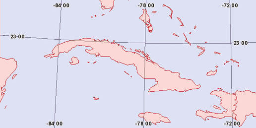 The extents of this map are set in meter units: EXTENT -848000 2225000 990000 2565000 |
| < Day Day Up > |
EAN: 2147483647
Pages: 138