Hack17.Understand Celestial Coordinate Systems
Hack 17. Understand Celestial Coordinate Systems
Orient yourself to the night sky. Celestial coordinate systems are used to specify the locations of stars and other astronomical objects. Four celestial coordinate systems exist, but only two of them are used commonly by amateur astronomers. Celestial coordinate systems are analogous to the geographic coordinate system of latitude and longitude used to specify locations on the earth's surface, but they are used instead to specify locations on the celestial sphere. The four coordinate systems differ only in what they designate the fundamental plane, called the equator, which bisects the sky into two hemispheres along a great circle. 2.8.1. Horizontal CoordinatesThe horizontal coordinate system, also called the altitude-azimuth or alt-az coordinate system, uses the local horizon as the equator, with the two poles straight up (the zenith) and straight down (the nadir). The location of an object is specified by two values called altitude and azimuth. Each of these is denominated in degrees (°), minutes ('), and seconds ("). One degree is divided into 60 minutes, and one minute is divided into 60 seconds. Accordingly, one degree contains 3,600 seconds.
Objects above the horizon have positive altitudes, and those below the horizon have negative altitudes. An object exactly on the horizon has an altitude of 0°. An object directly overhead (at zenith) has an altitude of +90°. An object that is straight down (through the earth, at nadir) has an altitude of 90°. The second component of an alt-az coordinate location is azimuth, which specifies the angular location of the object relative to north, which is designated 0°. If you face straight north and make a quarter turn (90°) to your right, you are then facing east, or 90°. Another quarter turn to the right takes you to facing south, or 180°. If you make yet another quarter turn to the right, you are facing west, or 270°. A final quarter turn to the right takes you back to north, or 0°. (Just as a 24-hour clock turns from 23:59:59 to 0:00:00, never reaching 24:00:00, azimuth turns from 359°59'59" to 0°0'0", never reaching 360°.) Because they describe the location of an object relative to the observer's position, alt-az coordinates have the advantage of being intuitive. Everyone understands the concepts of up, down, right, and left. But the inevitable consequence of using the observer's position as the fixed point of reference is that celestial objects move relative to that point of reference as Earth rotates on its axis. Accordingly, alt-az coordinates are insufficient by themselves to specify the location of a celestial object. You must also specify the location of the observer and the time of the observation. For example, to say that Sirius is located at altitude 32°41' and azimuth 206°59' is as meaningless as saying that a stopped clock reads correctly twice a day. The question is when and, in the case of a celestial object, from what location? But it is correct to say, for example, that for an observer located at latitude 36°09'N and longitude 80°16'W (that's us, folks) at 2130 EST on 9 March 2006 Sirius is located at altitude 32°41' and azimuth 206°59'. Figure 2-7 shows the location of Sirius from that site at that time, with an alt-az coordinate grid superimposed. But from the same observing site five minutes later, Sirius has moved relative to the observer, as shown in Figure 2-8. It is now located at altitude 32°13' and azimuth 208°17', which is to say 28 arcminutes (about half a degree) lower and 78 arcminutes (just over a degree) farther to the right. In the past, alt-az coordinates were seldom used because observers had only printed charts, which inherently lack observing location and time references. Nowadays, with goto scopes, digital setting circles, and planetarium programs that chart object positions in real time, alt-az coordinates are used very commonly. In particular, the overwhelming popularity of Dobsonian telescopes, which use alt-az mounts, has led to the odd situation that many experienced amateur astronomers now understand only the alt-az coordinate system. Figure 2-7. The alt-az location of Sirius from 36°09'N and 80°16'W at 2130 EST on 9 March 2006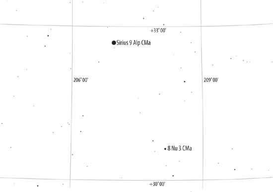 Figure 2-8. The alt-az location of Sirius from 36°09'N and 80°16'W at 2135 EST on 9 March 2006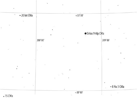 2.8.2. Equatorial CoordinatesThe equatorial coordinate system, also called the EQ coordinate system, uses the same fundamental plane and the same poles as the geographic coordinate system. The projection of Earth's equator onto the celestial sphere is called the celestial equator. The projections of Earth's north and south poles onto the celestial sphere mark the north celestial pole and the south celestial pole, respectively.
The difference between the equatorial and geographic coordinate systems is the point of reference used. The geographic coordinate system uses Earth as a fixed point of reference. As Earth rotates, the coordinate grid rotates with it, fixed to the planet's surface. Equatorial coordinates are fixed instead to the stars, so as Earth rotates the coordinate grid appears to move relative to earth's constantly changing position. Equatorial coordinates specify the location of an object with two values called Declination (abbreviated Dec, DE,or d) and Right Ascension (abbreviated R.A., RA, or a).
Right ascension is usually specified in clock time rather than by angle because the RA of an object determines what time that object rises on any specified date. Two objects at the same declination that are separated by one hour of RA rise one hour apart, regardless of what their declination is. For example, an object with RA 14h0m0s rises one hour before an object with RA 15h0m0s, if those objects are at the same declination. (But two objects with the same RA but different declinations do not rise at the same time.) Just as the actual distance on the earth's surface represented by one degree of longitude varies with the latitude, the distance represented by one hour of right ascension on the celestial sphere varies with the declination.
A given point on the celestial sphere appears to move as Earth rotates on its axis. Figure 2-9 shows the same area of the sky in alt-az terms that is shown in Figure 2-7, but this time with equatorial coordinates superimposed rather than alt-az coordinates. Figure 2-9. The equatorial location of Sirius from 36°09'N and 80°16'W at 2130 EST on 9 March 2006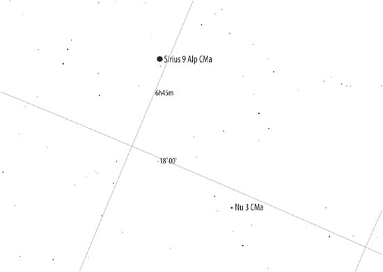 Figure 2-10 shows the same area of the sky in alt-az terms five minutes later. Again, Sirius has "moved," but this time the coordinate grid has moved along with it. So, although Sirius is now in a different place in the sky, it is in exactly the same place relative to the equatorial coordinate grid. Figure 2-10. The equatorial location of Sirius from 36°09'N and 80°16'W at 2135 EST on 9 March 2006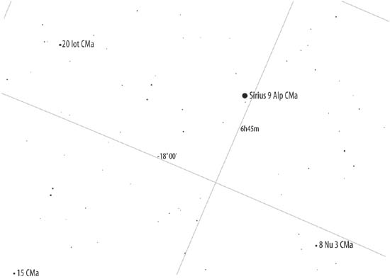
Back to the J2000.0 issue we mentioned earlier. The right ascension and declination of a star change gradually over time because Earth's axis of rotation wobbles rather than pointing directly at the celestial poles. Think of a child's top. When it first begins to spin, it does so smoothly about its axis. But as the top spins down, it begins to wobble, so that the axis begins to describe a circle rather than a point. Earth wobbles in its rotation in identical fashion, which is called precession. As a result of precession, Earth's axis draws a circle in the sky. The precession rate is about 1° every 72 years, which means it takes about 26,000 years for Earth's axis to trace the complete circle. Right now, Polaris is very close to the north celestial pole, but that wasn't the case until recently, and won't be the case in the future. Five thousand years ago, for example, when the Egyptians were building the first pyramids, the pole star was Thuban in the constellation Draco. One thousand years ago, when Robert's Viking ancestors were pillaging Europewhat is "Pillaging," anyway?the pole star was Kochab in Ursa Minor. Twelve thousand years from now, the pole star will be Vega in Lyra. Precession means that the right ascension and declination of stars changes according to the current position of Earth's axis, so the RA and DE of a star must be specified as of a particular date, which is called the epoch. For printed charts, that date has conventionally been set at 50 year milestones, using Julian (J) dates. For example, charts printed early in the 20th century used epoch J1900.0, which is to say the location of objects as of midnight on 1 January 1900. Charts printed during the middle part of that century used J1950.0 positions. Charts printed in the late 20th and early 21st centuries use J2000.0. Computerized scopes and planetarium software take the concept of epoch a step farther. They use the date epoch, which is to say the epoch as of the moment you are using them. For example, Table 2-5 shows the epoch J2000.0 and date epoch as of 9 March 2006 coordinates for Polaris, which is located close to the north celestial pole, and for Mintaka, which is located in Orion's belt, near the celestial equator
In a little more than six years, the RA of Polaris changes by 7m10.26s, or, in angular terms, nearly 1.8°, while the RA of Mintaka changes by only 18.98s (about 0.079°). But Polaris is located near the north celestial pole, so a 1.8° angular change in RA represents a very small change in terms of distance in the sky, while Mintaka is near the celestial equator, where a small angular change represents a much larger actual distance. (Just as a 0.079° change in longitude at Earth's equator represents about 5.5 miles on the ground, while a 1.8° change in longitude very near Earth's north pole may represent only a few feet on the ground.)
Solar system objectsthe Sun, Moon, planets, comets, asteroids, and so onare next-door neighbors in celestial terms, and so they show very large proper motions in both right ascension and declination. That means their coordinates vary noticeably from day to day and, for objects such as the Sun and the Moon that have very large proper motions, even from minute to minute. Every amateur astronomer needs to be familiar with equatorial coordinates. If you use an equatorial mount, you can locate dim objects by using your setting circles to "dial in" the proper coordinates. Conversely, if you happen to find an object while panning around the sky, you can read the coordinates of that object from your setting circles and use those coordinates to determine which object you were looking at.
But even astronomers who use alt-az mounts, such as Dobsonian scopes, need to understand equatorial coordinates, for a couple of reasons:
2.8.3. Other Coordinate SystemsIn addition to the horizontal coordinate system and the equatorial coordinate system, two other coordinate systems are used in astronomy:
Although neither of these coordinate systems is commonly used by amateur astronomers, there are times when the location of an object you may wish to observe is specified using one of these systems, so it's as well to understand them. |

EAN: 2147483647
Pages: 112