One of the things that makes Google Earth so useful is its capability to overlay other data on top of its maps. This data is added in the form of layers; available layers can be enabled via the Layers pane.
You've already seen several different types of layers in use. When you enabled the 3D buildings and terrain features, you added these layers to the underlying map. Disable the feature, and the layer is taken away.
In the Layers pane, layers are organized in folders. Double-click a folder to see and activate specific layers within the major layer category.
There are many other kinds of layers you can add to most Google Earth maps. Table 20.4 details some of what's available:
Table 20.4. Google Earth Layers
Layer | Description |
|---|
3D buildings | Displays three-dimensional buildings in major metropolitan areas |
Airports/transportation | Displays airports, heliports, and airport maps |
Alternative place names | Displays locations in different languagesEnglish, French, Italian, German, Spanish, Dutch, and Portuguese |
Banks/ATMs | Displays nearby bank and ATM locations |
Bars/clubs | Displays the locations of nearby nightclubs and bars |
Borders | Displays border information, including countries, states, counties, coastlines, and the like |
Census | Overlays various census data, where available |
Churches/cemeteries | Displays the location of nearby churches and cemeteries |
City boundaries | Displays city limit borders |
Coffee shops | Displays the location of nearby coffee shops |
Community showcase | The best of user-created layers |
Crime stats | Displays local crime statistics, where available |
DG coverage | Displays cloud cover information |
Dining | Displays the locations of nearby restaurants |
Earthquakes | Displays the location of recent earthquakes |
Fire/hospitals | Displays the locations of nearby fire stations and hospitals |
Gas stations | Displays the locations of nearby gas stations |
Geographic features | Displays bodies of water, mountains, and other features |
Golf | Displays the locations of nearby golf courses |
Google Earth community | Displays placemarks created by Google Earth users |
Grocery stores | Displays the locations of nearby grocery stores |
Lodging | Displays the locations of nearby hotels and motels |
Major retail | Displays the locations of nearby major retailers |
Movie/DVD rentals | Displays the locations of nearby movie rental stores |
National Geographic Magazine | Displays a variety of special layers created by the editors of National Geographic magazine |
Parks/recreation areas | Displays nearby parks and recreation areas |
Pharmacy | Displays the locations of nearby pharmacies |
Populated places | Displays cities, towns, villages, capitals, and so on |
Postal code boundaries | Displays boundaries of U.S. postal codes |
Railroads | Displays railroad tracks |
Roads | Displays the names/numbers of major highways, county roads, and streets |
School districts | Displays boundaries for elementary, secondary, and unified school districts |
Schools | Displays the locations for nearby schools |
Shopping malls | Displays the locations for nearby shopping malls |
Sports venues | Displays nearby sports stadiums, ballparks, and the like |
Terrain | Displays 3D elevation for the viewing region; this layer is limited to natural geographic features, like mountains and canyons, and is not available for cities and buildings |
Transit | Displays local and commuter rail lines |
U.S. Congressional districts | Displays boundaries for U.S. Congressional districts |
Volcanoes | Displays known volcanoes |
Water | Displays bodies of water |
Not all layers contain information for all locales. For example, you won't find 3D building data for the middle of the Nevada desert.
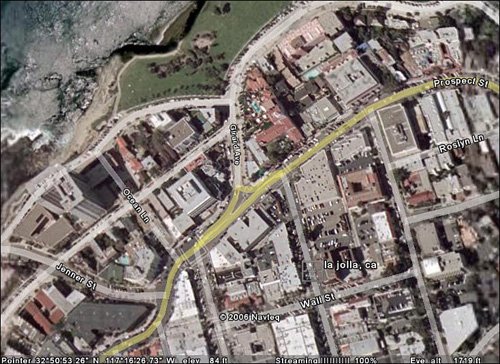
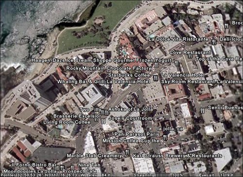
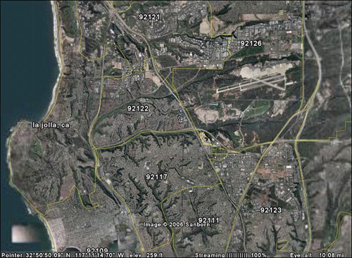
For example, Figure 20.24 shows a view of La Jolla, California with the Roads layer enabled; Figure 20.25 shows the same area with the Lodging layer enabled. At a longer view, Figure 20.26 shows the San Diego area with the Postal Codes layer enabled. You get the point.