Configuring View Options


That last bit of our tour draws our attention to the various view options available in Google Earth. There are a lot of options, more than we can cover here, but we'll try to address some of the most popular and useful ones.

Setting View Preferences

Most of Google Earth's view options are set from within the Options dialog box, shown in Figure 20.17. You open this dialog box by selecting Tools, Options.

Figure 20.17. The Options dialog box.


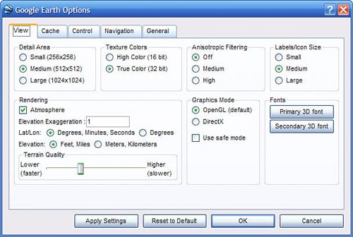
Within the Options dialog box, you want to select the View tab. From here you can adjust the settings detailed in Table 20.2:

Table 20.2. Google Earth View Settings

Setting

Description

Detail Area

Determines how much area within the viewer has high-resolution focus, calculated in pixels. Medium is the default setting; you should select Large only if your PC's graphics card has at least 32MB memory.

Texture Colors

Sets the color depth of the display; True Color (32 bit) displays a more realistic view.

Anistropic Filtering

This is a texture mapping technology that produces a smoother looking image, especially around the horizon (when viewing a tilted angle). You should turn this on only if your graphics card has at least 32MB memory.

Labels/Icon Size

Determines the default size for labels and icons in the viewer.

Rendering

Checking Atmosphere shows the atmosphere around the globe when viewed at full horizon or from space.

Elevation Exaggeration

Choosing a higher number exaggerates the height of tall objects (terrain and buildings) in the viewer.

Lat/Lon

Displays latitude and longitude in either degrees, minutes, and seconds or just degrees.

Elevation

Displays elevations in either feet and miles or meters and kilometers.

Terrain Quality

Adjust to display more or fewer terrain details.

Graphics Mode

Google Earth is a graphics-intensive application. If your PC has a high-powered graphics card, it can run in the better-looking Direct X mode. If, however, your PC has a less powerful graphics card (as do most notebook PCs), then you can run Google Earth in the less-demanding OpenGL mode. (Safe mode is used only when you're experiencing display problems.)

Fonts

Determines which fonts are used to display labels in the viewer.


Using Full-Screen Mode

By default, the Google Earth viewer appears in a window within the Google Earth window. To display the viewer full-screen, press the F11 key (or select View, Full Screen). To return to the standard mode, press F11 again.

Displaying a Latitude/Longitude Grid

To overlay a latitude/longitude grid on any Google Earth view, press Ctrl+L (or select View, Lat/Lon Grid). This grid tilts along with the overall view tilt; Figure 20.18 shows what this grid looks like.

Figure 20.18. Google Earth with a latitude/longitude grid overlaid on the standard view.
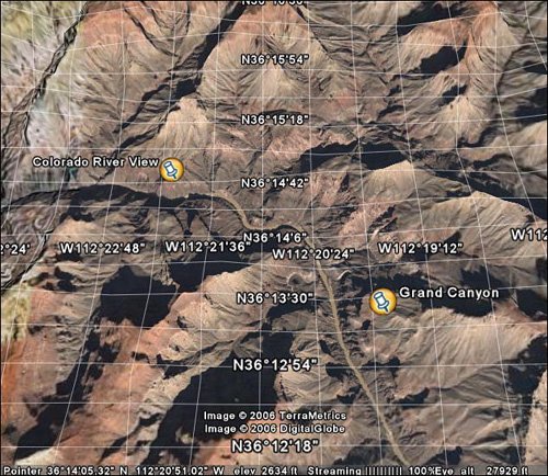

Displaying the Overview Map

There's one more view setting that can help you navigate Google Earth. This is the Overview map, which you switch on by pressing Ctrl+M (or by selecting View, Overview Map). As you can see in Figure 20.19, this is a similar map overview as you see in Google Maps.

Figure 20.19. The Overview map displayed in the Google Earth viewer.


The Overview map shows you where you are in the viewer in relation to the rest of the world. You can double-click anywhere in the Overview map to navigate to that location.


Googlepedia. The Ultimate Google Resource
Googlepedia: The Ultimate Google Resource
ISBN: 078973639X
EAN: 2147483647
Year: 2004
Pages: 370

flylib.com © 2008-2017.
If you may any questions please contact us: flylib@qtcs.net