Warchalking
During the great depression, American hobos developed a language of pictographs that they used to leave messages for one another, as shown in Figure 6-4. Using these symbols, a hobo could inform other hobos passing through a rail yard or town about dangers or where they could go to find food and shelter.
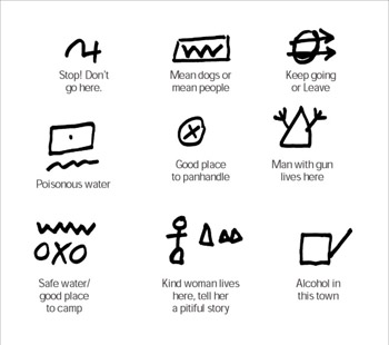
Figure 6-4: Hobo symbols
Hobo pictographs inspired an activity called warchalking, which is related to wardriving. Warchalking is when a wardriver uses chalk to mark symbols on walls or pavement that indicate the presence of a wireless access point (see Figure 6-5). From what I can gather, few people actually engage in warchalking. At WUGs that I’ve visited, I have yet to find a single person that actually does this, and a recent poll on netstumbler.com had zero respondents who indicated that they have warchalked.

Figure 6-5: Warchalking symbols
Wardrivers can use Global Positioning System (GPS) devices and mapping software to create computer maps showing the locations of hundreds of discovered access points. They can upload these maps and share them on Web sites, so getting out of a car to warchalk is pointless.
| On The Web | For more information on warchalking, visit www.warchalking.org. |
EAN: 2147483647
Pages: 145
- An Emerging Strategy for E-Business IT Governance
- Measuring and Managing E-Business Initiatives Through the Balanced Scorecard
- A View on Knowledge Management: Utilizing a Balanced Scorecard Methodology for Analyzing Knowledge Metrics
- Measuring ROI in E-Commerce Applications: Analysis to Action
- Technical Issues Related to IT Governance Tactics: Product Metrics, Measurements and Process Control