Geographical Data Types
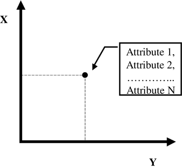
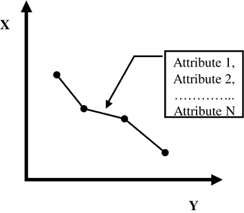
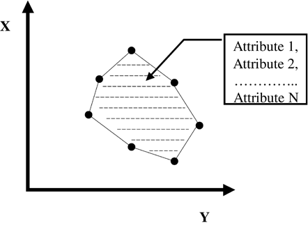
| To understand how map databases store information, it is important to understand the basic geographic data types used to represent real-world geographic phenomena. In the vector data model, geographic data is stored in discrete points, lines, and polygons. Points, lines, and polygons are respectively zero-, one-, and two-dimensional static representations of real-world phenomena in terms of simple x, y coordinates. PointsPoints refer to objects that have location and attribute information, but are not large enough to be represented as areas (see Figure 4.6). Whether an object is represented as a point or a polygon depends on the level of abstraction and scale of the map. Cities that would be represented as points in a country-level map might be represented as polygons in a regional map. Other examples of points include points of interest (POIs) and parcel centroids, such as postal codes or addresses. Points have no dimensions. Figure 4.6. Point Primitive. NodesNodes are a special type of point that represent a junction or the endpoint of a line. Nodes are the same as points in all other respects. Nodes provide information that includes connectivity between lines and information about adjacent polygons and enclosed islands. Lines and ArcsLines are one-dimensional objects that have length but no area (see Figure 4.7). Lines must begin and end with a node. In the case of a road, a line will represent the street center line. The actual width of a road will be an attribute of the line. Other attributes of a road might include street name , address range, speed, and direction of travel. At the country level, a line is an adequate representation of a road. At the regional level, a line might not be adequate and a road would be represented using a polygon area of paving. Lines might also be used to represent rivers and railways. An arc is a multisegment line. Figure 4.7. Line Primitive. PolygonsThe simplest definition of a polygon is a set of connected lines that form a closed mathematical figure (see Figure 4.8). Polygons can have any number of points and can be any shape or size. Other ways to represent a polygon include the set of x, y coordinates that form its boundary or the area contained by the boundary. Polygons can have holes, contain other polygons, and be directly adjacent to other polygons. Figure 4.8. Polygon Primitive. Linked AttributesEach geographic primitive has attached information that describes it. In mobile location services, the most important attributes relate to the road network, such as speed, street names , turn restrictions, and connectivity. Computer Storage of Geographic Data StructuresNow that we have developed a conceptual notion of our map using points, lines, and polygons, we must consider how this data is stored in a computer. The method used to store this data has a large impact on how large the map database is and how quickly data can be retrieved and used in a mobile location services application. Simple spatial entities have the following characteristics: points will have an (x, y) coordinate, a simple line with only two nodes will have two (x, y) coordinates, an arc will have n number of (x, y) coordinates, and a polygon could have either n number of lines or n number of points. To achieve sufficient precision, it is necessary to use a 32-bit or 64-bit real data type for each value in the coordinate pair. Thus, because there are 8 bits in a byte, a point would require 8 or 16 bytes of storage, a line requires a minimum of 16 bytes of storage, and a polygon requires a minimum of 24 bytes. Because map databases can contain many millions of spatial entities and each can have linked attributes, it is easy to see how a map database can become very large. |
EAN: 2147483647
Pages: 150