Hack67.Use GPS on Your Car PC
Hack 67. Use GPS on Your Car PC
With GPS, your car PC can always know where on Earth it is, and with wireless Internet, it can also tell the world. The Global Positioning System (GPS) provides fairly accurate (to within a few meters) location coordinates for anyone who has a GPS receiver. GPS receivers come in a variety of shapes and sizes, from standalone units with LCD screens showing your location in latitude and longitude, to units with a little map and an "X" marking where you are. The GPS hardware and antenna can be made smaller than a matchbox, and you can purchase tiny CompactFlash-sized GPS receivers for PDAs, or small USB dongle receivers for PCs (see Figure 6-10). Figure 6-10. A USB GPS receiver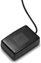 Knowing exactly where you are can be useful for many different applications, and recording everywhere you've been can be even more useful. Maybe you run a business with a fleet of automobiles, and you want to be able to store your routes on a daily basis and improve efficiency by examining exactly where you went. Or maybe you're going on a cross-country trip and you want to keep a journal of your travels. Why not include the coordinates of the path you take? Even better, you can upload your coordinates to a web page as you travel, so others can keep track of your vehicle in real time. This feature can be used for people to monitor your progress while you're making a trip, so you can keep track of someone who borrows your car, to monitor the positions of company vehicles in real time, or even for stolen vehicle recovery (assuming your car PC always runs when the car is driven). GPS is standard, well documented, and easy to program for, and while you can simply purchase navigation software [Hack #71], none of the navigation programs on the market are designed with all the features I've mentioned. In this hack, I'll briefly explain how to understand the language GPS units speak and then provide several example programs (available for download at http://www.oreilly.com/catalog/carpchks) that illustrate the features I've mentioned.
6.7.1. How GPS WorksThe basic way that GPS works is that satellites in known locations in space transmit radio signals with embedded timestamps to Earth. Your GPS receiver measures the time that it takes for four or more of these different satellite signals to reach your location, and compares that information to the current time. If you've ever heard of "triangulating your position," it's like that, but with GPS you're "quadrangling" or "sextangling" your positionthe more GPS satellites your receiver can get a signal from, the more points of reference it has to calculate a more accurate position. When you first power up a GPS receiver, it has to spend a while getting a "lock" on the satellites, and it has to find at least four signals that it can use to calculate a position. If your GPS receiver has been powered on recently (a "warm start"), it will remember at least which hemisphere it is in, and perhaps the general latitude and longitude, and so will be able to get its bearings in a matter of seconds. However, when you turn on a GPS receiver for the first time (or when you turn it on after its batteries have been removed and it has "forgotten" everything), it has to literally figure out where on Earth it is, which can take a few minutes. The GPS represents coordinates in the same way that the Greeks originally used coordinates. The sky is divided into 12 regions, which are further split into 30 one-degree segments (12 * 30 = 360). Locations in GPS are represented using the standard trigonometric system of Degrees, Minutes, and Seconds, such as: 47 Degrees 38 Minutes 12.372 Seconds North Latitude 122 Degrees 7 Minutes 58.8 Seconds West Longitude On a computer, Minutes and Seconds are often mathematically combined to one decimal fraction. For example: 47.63677 Latitude -122.13300 Longitude
Most GPS receivers communicate their current location coordinates to the computer using the NMEA 0183 protocol. (Make sure the GPS receiver you purchase conforms to this format.)You can find out more information about this standard from the National Marine Electronics Association (NMEA) web site, at http://www.nmea.org/pub/0183. Most GPS devices for the computer run at a nice, mellow speed of 4,800 baud (for comparison, modems run at 56,000 baud) and speak in ASCII characters over a serial port or USB port. If you plug a GPS unit into your serial port, run a terminal program (e.g., Hyperterminal on Windows), and set the baud rate correctly, you'll see what the GPS device is saying. The NMEA protocol is fairly simple. Once connected, the GPS device will output a string every second or so containing its latitudinal and longitudinal data. While the GPS unit is still figuring out where it is, it will not output location coordinates, but it may report which satellites it sees and what it is currently doing. Writing a program to process GPS information is as straightforward as reading data sent to the serial port and processing some text. This is easily done in any programming or scripting language. 6.7.2. Reading and Understanding GPS SentencesAssuming that you have your GPS device attached and configured (though usually not much configuration is necessary, other than making sure that the port and speed settings are correct), reading information from it is very easy, since it talks in ASCII and provides data that is close to what is necessary for this hack. The device outputs comma-delimited sentences. The beginning of each sentence is a code that explains what is in the rest of the sentence. The sentences that tell you your current coordinates start with $GPGGA. These will probably be the only sentences that you are interested in, but you can check the NMEA 0183 standard if you want to know more. The most interesting parts of the sentence are listed in Table 6-2.
6.7.3. Creating a Record of Your TravelsI've written a handful of Perl scripts to illustrate how easy it is to work with GPS information. You can download the source code for each of these examples at http://www.carpchacks.com/gps/. The programs were developed on a Windows XP machine running Perl. You can get Perl for Windows from ActiveState (http://activestate.com/Products/ActivePerl/). The second two code examples require an additional script to be running on an Internet-based web server running Perl. These scripts require IIS or Apache, Perl, and write access to a file so they can store GPS locations. Each of the Perl scripts running on the car PC will be storing locations to a file. Like any log file, this can get very large over time. Whatever method you use to get the data off your car PC, you should have some mechanism for moving and storing it all. These scripts are examples, so if you want a more secure solution that isn't viewable by the whole world, you may want to password-protect the script on your web server. Making a robust, secure version of a GPS tracking web service is left as an exercise to the reader.
6.7.4. Displaying GPS Data on a MapAll of this tracking information is great, but without pretty graphical maps at the end, there's little payoff for all the hard work. Unfortunately, high-quality, high-resolution mapping software costs money, and the terms of service of most online mapping sites do not necessarily permit you to generate free, real-time illustrations of your car PC's travels (i.e., they'll want you to pay for that functionality). A great site that does allow this (and which I've included in my sample code) is Acme Labs (http://mapper.acme.com). Another useful site with few restrictions on its use is http://terraserver.microsoft.com. Figure 6-11. A real-time position map using http://mapper.acme.com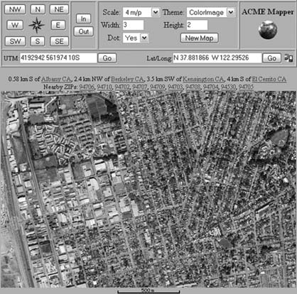 MSN Maps, Yahoo! Maps, MapQuest, and Google Maps can all display graphical maps of your location information if you learn how to generate the right URLs, and depending on the license agreements of these sites, you may be able to link to them with your location (but always check the site's acceptable use policy before doing so).
Figure 6-12. A map generated with MapPoint 2004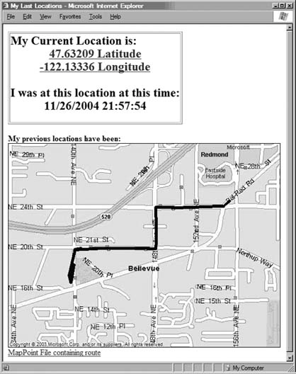 As mentioned in the description of Example #3, you can also run MapPoint (or a similar mapping product with an API) to generate the maps on your car PC and then simply upload them. This uses more bandwidth, but yields potentially better-looking results than a free online mapping service can provide. Each of the major search engines is in the process of adding a local search capability, and this is causing them to revamp, enhance, and solidify their online mapping technologies. At the same time, improved mobile Internet connectivity is becoming available. It's a great time to be tinkering in this area, as the raw materials for some really innovative telematics hacks are now readily available.
Figure 6-13. A car PC location using Google Maps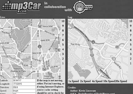 6.7.5. See Also
J.P. Stewart |
